
The Old San Antonio Road in San Augustine County
The Old San Antonio Road in San Augustine County
- Map of the Old San Antonio Road in San Augustine County
- Route Details
- Highway 21 East of San Augustine
- Mission Dolores
- San Augustine
- Highway 21 West of San Augustine
Mission Dolores on Ayish Bayou was one of the original destinations of El Camino Real in the early 1700s. The road came in from Nacogdoches in the west, passed by the mission, and went east to the Sabine River. The town of San Augustine was founded north of the old mission. Highway 21 generally follows the Old San Antonio Road from one end of the county to the other, except in and near the city of San Augustine, where much of the old route has been lost.
Northern San Augustine County is on the vast Haynesville Shale natural gas formation, so gas wells and pipes are a common sight along Highway 21. The highway is also the address of several large chicken farms.
Map of the Old San Antonio Road in San Augustine County
[-]Collapse Map [+]Expand Map
Route Details
- Route lost from the Sabine-San Augustine County line at a spot 0.25 mile north of State Highway 21 for 1.4 miles to SH 21 just west of Farm-to-Market Road 1.
- SH 21 from just west of FM 1 for 4.6 miles to County Road 127. This segment has an exact conformance to the OSR. SH 21 has two lanes, undivided, with no shoulder.
- Route lost from SH 21 at CR 127 for 1.0 miles to FM 3483.
- SH 21 from FM 3483 for 0.4 miles to SH 147/Clark Street in San Augustine. Exact conformance.
- Route lost from SH 21 at SH 147/Clark Street for 1.7 miles to SH 147 at Price Drive.
- SH 147 from Price Drive in San Augustine for 0.4 miles to Ayish Bayou, inexact conformance. SH 147 has two undivided lanes, with curbs and no shoulder.
- Route lost from SH 147 at Ayish Bayou for 1.2 miles to SH 21 at CR 280.
- SH 21 from CR 280 for 3.9 miles to CR 278, loose conformance. This segment may include part of CR 280, part of CR 220, and a clearing that exists from CR 220 to SH 21, now used as a gas pipeline. SH 21 has two undivided lanes with no shoulder.
- SH 21 from CR 278 for 2.9 miles to CR 254 at Denning, exact conformance. SH 21 has two undivided lanes with no shoulder.
- SH 21 from CR 254 at Denning for 3.9 miles to Attoyac Bayou (the San Augustine-Nacogdoches County line), inexact conformance. SH 21 has two undivided lanes with no shoulder.
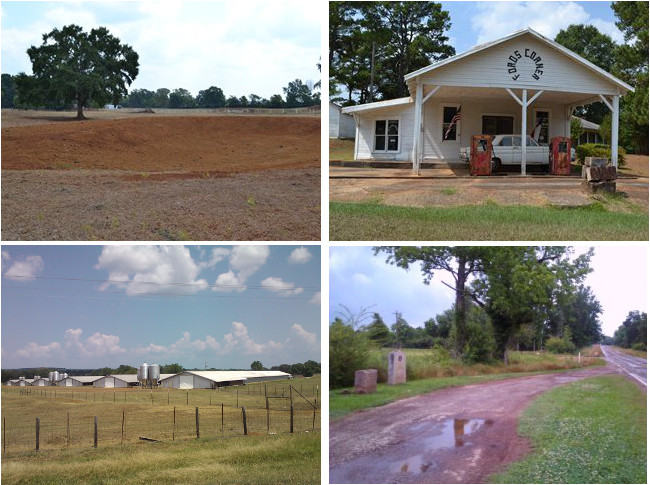
Bottom: Tyson chicken farm; Site of Elisha Roberts' home and OSR Marker #6.
Highway 21 East of San Augustine
After Highway 21 passes from Sabine County into San Augustine County, it leaves the Sabine National Forest. The heavy, uniform forest of pine trees gives way to a blend of pine and hardwood forests and cleared farmland and pastures. The rusty-colored soil seen throughout Sabine and San Augustine Counties is especially noticeable here, and toponymns like "redland", "red hill", "red ridge", etc. are common.
Zively's route of the Old San Antonio Road crossed the county line about a quarter mile north of present-day Highway 21. This route does not appear on any available maps, but it does match a land grant boundary on a 1910 San Augustine County map. The two routes converge at, or just to the west of, Texas Farm-to-Market Road 1.
The intersection of Highway 21 and FM 1 is the location of a small community called Fords Corner, which had fewer than 30 residents in 2000. Fords Corner was known mainly for its general store which, though closed since 1983,1 still sits prominently atop a hill on the highway. With its mowed yard, painted exterior, and flags on display, it looks from a distance like the owners have stepped out and may return at any minute.
West of Fords Corner is a Tyson chicken farm, one of many poultry hatcheries along Highway 21.
One of San Augustine County's first prominent residents, Elisha Roberts, moved in and built a home for himself east of Ayish Bayou in 1824. Roberts was elected the unofficial alcalde (mayor) of the Ayish Bayou district in 1831. His house served not only as the local seat of government, but was also a boarding house for travelers. Sam Houston, Stephen F. Austin, William B. Travis, David Crockett, and James Bowie were all known to have stayed there. Roberts was one of the co-founders of San Augustine in 1834. Zively placed an oak post at the site of this well-known house, which apparently was still in existence as of his 1915 survey. The house is no longer there today, but the state has erected a historical marker for it next to OSR Marker #6.
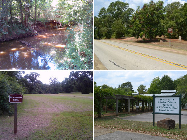
Bottom: El Camino Real at the Mission Dolores campground; Mission Dolores visitor center.
Mission Dolores
Mission Nuestra Señora de los Dolores de los Ais - or Mission Dolores for short - was established with Spain's second wave of east Texas mission building in 1716. It was closed at its original location in 1719, then reopened in 1721 at its final location on Ayish Bayou. As one of the original destinations on El Camino Real, Mission Dolores was one of the reasons the royal road was founded. It was the easternmost Spanish settlement on the road in present-day Texas for the next 52 years. Dolores was abandoned in 1773 and was destroyed by natives quickly thereafter.
Anglo settlers who came into the Ayish Bayou area in the late 1700s identified a location that they named Mission Hill, believing it to be the site of Mission Dolores. A state historical marker for the mission and OSR Marker #7 are now at Mission Hill.
The identification of Mission Hill as the site of Mission Dolores always left archeologists unsatisfied, however. In the 1970s, researchers discovered that Mission Dolores was actually located several hundred yards east of Mission Hill, directly beneath present-day State Highway 147.
The area surrounding the old mission site has been developed as a visitor center and campground. The campground offers a view of a grassy area purported to be part of El Camino Real, although it takes a trained eye and possibly a good imagination to see it. (Also see our article, "Using Lidar to Map El Camino Real in San Augustine.") Unfortunately, the visitor center is not what it could be, and offers little to no insight into either Mission Dolores or El Camino Real.
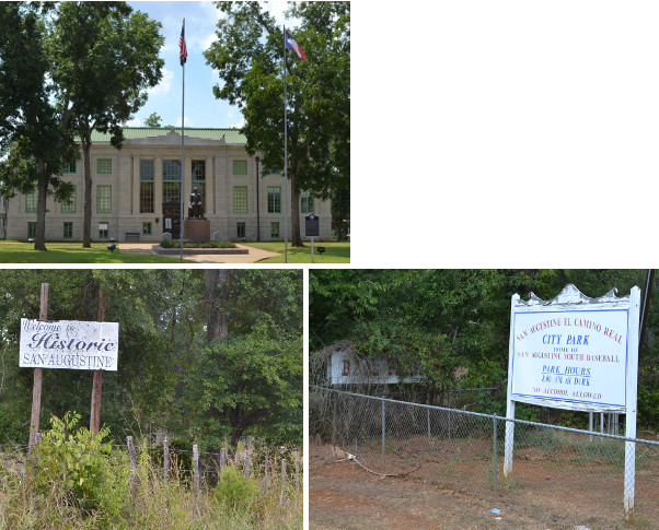
Bottom: Welcome sign; Entrance to San Augustine El Camino Real City Park.
San Augustine
Anglo settlement of present-day San Augustine began in the late 1770s. The city of San Augustine was founded in 1834, about a half mile to the north of where El Camino Real looped around Mission Dolores. In 1837, San Augustine County was organized, and the city of San Augustine was made the county seat.
During the Republic of Texas (1836-1845), San Augustine was the customs station for immigrants and imports coming from the United States. San Augustine thrived in the mid-to-late 1800s, being home to two sawmills, several cotton gins, newspapers, law offices, and churches. The first county courthouse was built in the center of the town square in 1854. The current building was completed in 1927.
Maps of the city and county of San Augustine from 1910 and earlier show the Old San Antonio Road, which curved around the south side of the city, as the main east-west highway, labeling it either Kings Highway or Nacogdoches Road. Newer crossings of Ayish Bayou at Main Street and Columbia Street, however, were more convenient for residents of San Augustine, as well as for travelers who wished to stop in town. The old Kings Highway route around town was developed over to make room for with new city streets. City and county maps from 1918 and later show no traces of the original route. State Highway 147, which was built in the 1930s, did reuse a short section of the OSR around Mission Hill. That, and short pieces of Main and Columbia Streets west of Carrizo Creek, are the only parts of El Camino Real in San Augustine that still exist. For a more detailed analysis, see our article, "Using Lidar to Map El Camino Real in San Augustine."
San Augustine's population peaked at 2,584 in 1960. Today, much of the town's public property - with peeling paint, untrimmed trees, and rust - looks neglected and forgotten.
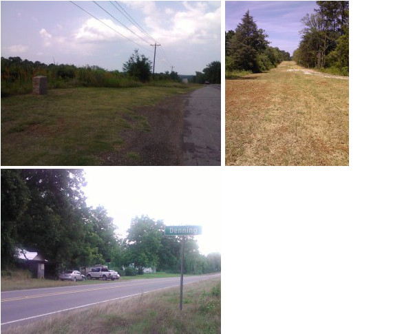
Bottom: Denning.
Highway 21 West of San Augustine
OSR Marker #8 is near a large underground gas pipeline, one of many in the county. The pipeline right-of-way corresponds closely with the Old San Antonio Road on Zively's sketch of the area. Beginning at the marker, Highway 21 follows the route of the Old San Antonio Road until Denning.
Denning was founded around 1891. The town had about 200 inhabitants when Zively made his survey in 1915. There is very little left of it today.
Zively's sketch shows that west of Denning, the Old San Antonio Road dipped south, went west for about a mile, then returned north. Present-day County Road 256 does something similar at about the same location, but neither it nor Highway 21, which simply goes straight west through this area, match the route of the Old San Antonio Road.
At about the spot where CR 256 rejoins Highway 21 is OSR Marker #9. From there, Highway 21 inexactly follows the Old San Antonio Road to the Nacogdoches County line.
Page last updated: May 31, 2019
1That is, one of the gas pumps has a sticker showing it was last inspected in May 1983.
- Zively, V.N. - "Field Notes and Detail Map of the Kings Highway", 1916
- Carson, David - field notes observed and recorded in 2013
- Texas State Historical Association - The Handbook of Texas Online
- Stephen F. Austin University East Texas Research Center