
The Old San Antonio Road in West Nacogdoches County
The Old San Antonio Road in West Nacogdoches County
- Map of the Old San Antonio Road in West Nacogdoches County
- Route Details
- Nacogdoches
- Yseleta Creek and Bayou Loco
- SH 21 / Douglass
The Old San Antonio Road runs through the northern half of Nacogdoches County. The western half of the road includes the city of Nacogdoches. After leaving Nacogdoches, the road passes through about 17 miles of countryside. The small community of Douglass is the only population center among the farms, pastures, and natural gas fields.
As is the case throughout east Texas, the Old San Antonio Road is preserved today largely State Highway 21. There are also some short sections where the OSR follows small dirt county roads, and a few places where it is no longer marked by any road.
Map of the Old San Antonio Road in West Nacogdoches County
[-]Collapse Map [+]Expand Map
Route Details
- As discussed in the article about east Nacogdoches County, Zively's surveyed route of the Old San Antonio Road east of Nacogdoches may be incorrect, because it shows a different route than the known path of El Camino Real, which is County Road 302 or "Upper Melrose Road". Regardless of whether it is right or not, Zively's route meets CR 302 at OSR Marker #14. From there, the discrepancy between his route and the known route ends. It is 0.3 miles from OSR Marker #14 along CR 302 to State Highway 7. CR 302 is a paved single-lane road.
- SH 7 from CR 302 for 1.0 miles to SH 21. Highway 7 has an exact conformance to the OSR. It has four undivided lanes, with shoulders and curbs.
- SH 21 from where SH 7 merges with it on the east side of Nacogdoches for 3.7 miles through Nacogdoches to CR 706. This segment has an exact conformance to the OSR. The highway is marked as SH 7 / SH 21 for 1.3 miles, until SH 7 splits off downtown. The highway is four lanes, undivided, with shoulders and curbs, except through the historic district downtown, where it is two lanes, undivided, with curbs, and is surfaced with brick.
- CR 706 for 0.6 miles where it crosses Yseleta Creek at a different crossing than SH 21. This road conforms exactly to the OSR. It is a one-lane paved road.
- SH 21 from where CR 706 rejoins for 4.0 miles to CR 825, inexact conformance. Highway 21 has two undivided lanes, with shoulders, plus climbing lanes where there are hills.
- CR 825 from SH 21 for 0.3 miles until it stops at the Hayter Ranch. CR 825 is a one-lane paved road. This segment has an inexact conformance to the OSR where it intersects with SH 21, but otherwise is true.
- The OSR is on private land from CR 825 for about 1.7 miles to CR 829. It is partly preserved by a private ranch road, but some of it now exists only as a clearing in the woods.
- CR 829 from where it meets the private land for 0.5 miles to SH 21, exact conformance. CR 829 is a one-lane dirt road.
- SH 21 from CR 829 for 4.9 miles from CR 829 to where it turns southwest as it approaches Douglass, exact conformance. Highway 21 has two undivided lanes, with shoulders, plus climbing lanes where there are hills.
- Route lost for approximately 1.0 mile north of Douglass.
- SH 21 from approximately CR 3 west of Douglass for 3.6 miles to the Cherokee County line. This segment has an exact conformance to the OSR until it approaches the Angelina River, where it only conforms loosely. SH 21 has two undivided lanes, plus climbing lanes for hills, and shoulders.
Nacogdoches
Present-day Nacogdoches was the site of one of the six east Texas missions founded by Domingo Ramón's expedition in 1716. The Mission Nuestra Señora de Guadalupe de los Nacogdoches, or Mission Guadalupe for short, was established for the Nacogdoche tribe, one of the many native east Texas tribes belonging to the Caddo federation. It was vacated in 1719, then re-established in 1721. After three of the six missions moved to San Antonio in 1730, Guadalupe became the westernmost of the three remaining missions on El Camino Real - the other two being Mission Dolores at present-day San Augustine and the mission at Los Adaes, outside present-day Robeline, Louisiana. Los Adaes was, at the time, the capital of Spanish Texas, and it also had a presidio (fort). A Spanish citizen born at Los Adaes would later found the city of Nacogdoches.
Throughout the approximately 80 years that Spain had missions in east Texas, a trading culture developed there that was at odds with the law of the land. Under Spanish colonial law, the missions were required to send any goods they produced back to Mexico, and they were likewise required to purchase all of their goods from Mexico. Due to the missions' remoteness, however, goods from Mexico were scare and expensive. Trading with the French at Natchitoches, a mere twelve miles from Los Adaes, was so much more practical. Spanish officials in Texas realized that trade with the French was the only way the missions could survive, and generally turned a blind eye to what the central government considered "smuggling". On occasion, however, the smuggling became so flagrant that officials felt they had to make arrests. One such instance was when Antonio Gil Ybarbo (also written as Y Barbo, Y'Barbo, YBarvo, or Ibarvo) of Los Adaes was imprisoned for seven months for buying horses stolen by Indians from other Spanish settlements for sale to the French and English. Ybarbo's fortunes changed when a new governor who had a different view of smuggling came along. Governor Baron de Ripperda released Ybarbo and put him in charge of procurement at Los Adaes.
In 1773, Spain closed all of its east Texas settlements. All missionaries, soldiers, and other Spanish citizens from Nacogdoches to Los Adaes were ordered to move to San Antonio. They did, but they did not stay there long. Many of the displaced east Texans, most of whom were from Los Adaes, had been born and raised in the Piney Woods and were unhappy with being required to live in San Antonio. Ybarbo, the spokesman for the displaced Adaeseños, received the governor's permission to settle his people on the Trinity River. Ybarbo and his group founded the town of Bucareli in present-day Madison County in 1774 and lived there for a few years, but they became doomed once the the hostile Comanche Indians found them and determined to destroy them. They also had flooding problems. Without asking permission first, Ybarbo moved the group to the old Mission Guadalupe in 1779 and began building the pueblo (town) of Nacogdoches. The governor, aware of the hardships Ybarbo's people endured at Bucareli, consented to this move after the fact and appointed Ybarbo to be the magistrate of the new community. Ybarbo laid out the town and built a stone house for himself, later known as the Old Stone Fort, on the camino real.
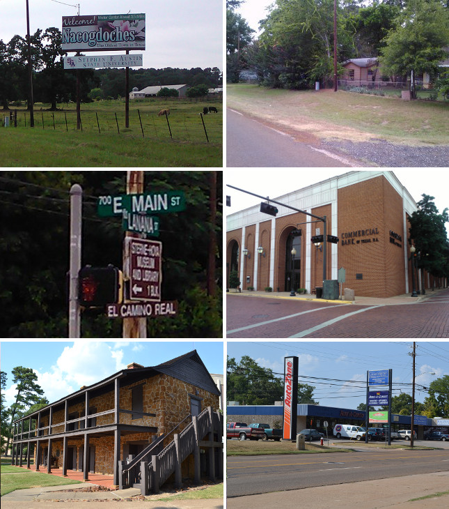
Middle (l to r): Nacogdoches street sign; OSR Marker #15 at the former site of the Old Stone Fort.
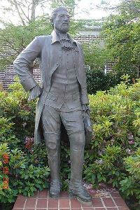
Bottom: Old Stone Fort replica at Stephen F. Austin University; Mission Guadalupe historical marker.
The culture of smuggling and operating under a different law than Spain's, which had been a way of life for Ybarbo and the other residents of Nacogdoches, shaped the character of the new town, making it a haven for schemers and separatists. For the next fifty years, every discontented Spaniard or ambitious Anglo who had dreams of liberating Texas from Spain or Mexico launched his campaign from Nacogdoches, generally using the Old Stone Fort as his headquarters. These filibusters and revolutionaries included Philip Nolan in 1794, Gutiérrez and Magee in 1812, James Long in 1819, and Haden Edwards in 1826.
Nacogdoches County was one of the Republic of Texas' original 23 counties. As Nacogdoches was one of the three largest cities in Texas at that time, it was naturally the county seat. Being on neither a railroad nor a navigable river stunted its growth after the Mexican-American War, however. It remains one of Texas' largest 100 cities, thanks in large part to Stephen F. Austin University, which was founded there in 1923.
The Old San Antonio Road surveyed by V.N. Zively in 1915 entered Nacogdoches from the east between the two existing state highways, 21 and 7. County Road 302 comes close in some places to Zively's route.1 Near OSR Marker #14, the OSR coincides with CR 302/Upper Melrose Road until it merges with SH 7, which then merges with SH 21. At that point, SH 21 or Main Street is also known as El Camino Real until exiting the west side of town at Loop 224/U.S. Highway 59.
The Old Stone Fort, at the northwest corner of Main and Fredonia streets, was dismantled in 1902 and was subsequently replaced by another commercial building. OSR Marker #15 is at the site today, along with a state historical marker. A replica of the Old Stone Fort, made using the original building's materials, was constructed at Stephen F. Austin College in 1936.
Mission Guadalupe was not preserved. Its site at North and Muller Streets, about 0.4 miles north of Main Street/SH 21, is indicated by a state historical marker.
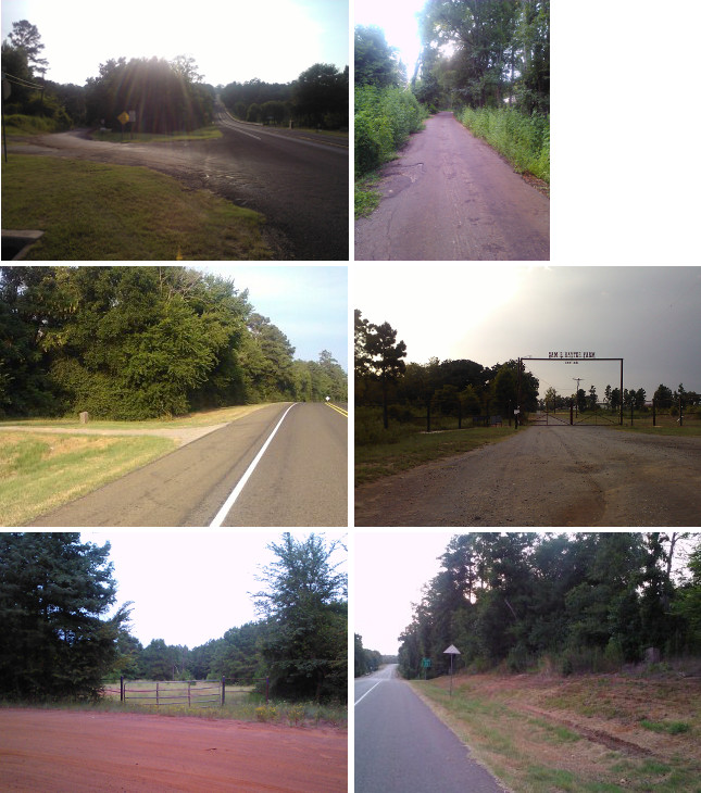
Middle (l to r): Site of OSR Marker #16; OSR transition from CR 825 to a private ranch road.
Bottom (l to r): OSR re-enters public land at CR 829; Site of OSR Marker #17.
Yseleta Creek and Bayou Loco
The countryside west of Nacogdoches features a number of creeks and bayous that affected the route of the Old San Antonio Road in the 1700s and 1800s. With its modern construction, Highway 21 was not constrained to follow the old highway's water crossings, so it takes a shorter, straighter route. The old road's crossing at Yseleta Creek was preserved, providing a rare chance to see the two routes side-by-side. County Road 706 offers a window into the past, showing what the Old San Antonio Road must have looked like all over east Texas before Highway 21 was built.
For the next few miles, Highway 21 follows the Old San Antonio Road very closely. OSR Marker #16 is at its original location on the highway in this sparsely-populated part of the county.
When Highway 21 reaches County Road 825, it begins descending into a moderate valley irrigated by Bayou Loco and several other creeks. Today, Highway 21 cuts straight across this well-watered area, passing just past the north end of Lake Nacogdoches, which was created when Bayou Loco was dammed in 1976. The Old San Antonio Road, however, swung well to the north of this area, avoiding most of the lowlands. A traveler today can take the OSR via CR 825 as far as the entrance to the historic Hayter Ranch. There, a gate blocks public access to the OSR, turning it into a private ranch road. Somewhere further in, the road diminishes to only a clearing in the woods. It then emerges on the west side, crossing another fence back onto public land. There, County Road 829 follows the route of the OSR back to Highway 21. The total distance of the Old San Antonio Road made up by these county roads, private road, and clearing is 2.5 miles, compared to the 2.0 miles it takes Highway 21 to connect the same two points.2
Just west of the where the Old San Antonio Road rejoins Highway 21 at CR 829 is OSR Marker #17, which is at its original location.
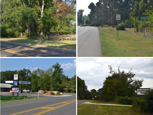
Bottom (l to r): Douglass; cattle ranch sign west of Douglass.
SH 21 / Douglass
From OSR Marker #17, Highway 21 coincides with the Old San Antonio Road for 4.5 miles towards Douglass.
The town of Douglass was founded 4 miles east of the Angelina River in 1836. It was named for Kelsey Harris Douglass, a prominent Nacogdoches merchant who became a Congressman and general in the Republic of Texas. Nacogdoches County maps from the 1800s and early 1900s show Douglass as being along the Old San Antonio Road. Apparently, it moved south around the turn of the century, however. Zively's 1915 survey shows Douglass as being south of the royal road, not on it. He placed a survey post on the Kings Highway, but when Highway 21 was built in 1917 or 1918, it departed from the Kings Highway and went instead into Douglass's new location. Consequently, OSR Marker #18 was left in a place where there was no longer a road. It has since been moved to Farm-to-Market Road 225, 0.4 miles north of Highway 21, close to its original location.
Today, Douglass has a few businesses on Highway 21, including the only gas station in the county on Highway 21 outside of Nacogdoches. There is a modern school building on FM 225, just south of Highway 21.
Past Douglass, Highway 21 rejoins the Old San Antonio Road and follows it to the Cherokee County line. This extreme western edge of Nacogdoches County is beyond the Haynesville Shale formation that makes up the subsurface of much of east Texas and northern Louisiana. The natural gas fields that are a constant sight along Highway 21 in Nacogdoches and San Augustine Counties are not seen west of Douglass. Instead, cattle ranches are more prominent. Chicken farms, common throughout the county and all of east Texas, are also seen here.
Page last updated: January 15, 2015
1As discussed in our tour of east Nacogdoches County, it is possible that Zively was mistaken in not including all of CR 302 in his route.
2Some modern maps designate this section of the OSR as "Old TX-21" or "Old Hwy 21" despite the fact that it has never been part of Highway 21, or any other state road. The idea that Highway 21 once used this route appears to be of a recent origin.
- Zively, V.N. - "Field Notes and Detail Map of the Kings Highway", 1916
- Carson, David - field notes observed and recorded in 2013
- Texas State Historical Association - The Handbook of Texas Online