
The Old San Antonio Road in South Houston County
The Old San Antonio Road in South Houston County
- Map of the Old San Antonio Road in South Houston County
- Route Details
- Southwest of Crockett
- SH 21 Northeast of the Trinity River
Houston County between Crockett and the Trinity River is mostly level country consisting of farms, ranches, and small communities. The first few miles of the Old San Antonio Road route on the outskirts of Crockett have been lost, but the rest of the route in south Houston County is on State Highway 21.
Map of the Old San Antonio Road in South Houston County
[-]Collapse Map [+]Expand Map
Route Details
- From County Road 3015 for 7 miles to Farm-to-Market Road 2967, Highway 21 and the OSR route are intertwined with and parallel to each other. County Road 3060 preserves the historic route exactly for 1.2 miles of this segment, as do small sections of Highway 21, but a great deal of the OSR along this segment is lost.
- SH 21 from FM 2967 for 13.3 miles to the Trinity River, which is the Madison County line. Highway 21 has a very close conformance to the OSR. It has two undivided lanes with shoulders.
Southwest of Crockett
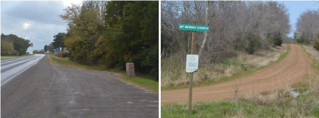
Southwest of Crockett, several ranches and farms have their entrances on Highway 21, along with a couple of cemeteries. The modern highway is roughly in the same location as the Old San Antonio Road, sometimes running parallel to it, sometimes crisscrossing it. Only at the current location of OSR Marker #30 do the two routes actually converge, and then only for a few feet. For several miles north of the marker, the original route of the Old San Antonio Road has completely disappeared.
Highway 21 follows the authentic San Antonio Road route for a few feet from Marker #30 to County Road 3060. CR 3060 then forks off and preserves the authentic road for 1.2 miles until it rejoins Highway 21 at FM 2967. CR 3060 is a one-lane dirt road bordered by walls of trees on either side. There is one clearing along the road, where a church sits on a hill.
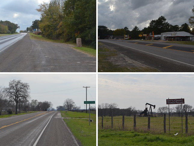
Bottom (l to r): Mapleton signpost, with OSR Marker #32 seen in background; Oil derrick at Sand Ridge.
SH 21 Northeast of the Trinity River
Highway 21 accurately preserves the route of the Old San Antonio Road all the way from Farm-to-Market Road 2967 for 13.3 miles to the Madison County line at the Trinity River. This is the longest unbroken section of the Old San Antonio Road in east Texas that is accurately preserved by a single modern public road. The countryside in this rural area consists mainly of farms and cattle ranches.
OSR Marker #31 is preserved at its original location northeast of Austonio.
The town of Austonio is at Highway 21 and Farm-to-Market Road 1280, about 14 miles southwest of Crockett. It was founded in 1900 as Pearville. Zively did not indicate its existence on his 1915 survey. The town changed its name to Austonio - a combination of Austin and San Antonio - in 1930 after a contest was held to determine the new name. Austonio's population peaked at 150 in 1940. Its population in 2000 was 37. Today, there are some businesses, a church, and a fire station at the main intersection.
Moving southwest along the Old San Antonio Road, Zively noted "Carsons Ranch." That ranch does not exist today, but it would have been on the north side of Big Creek.
The area south of Big Creek was settled by T. J. Maples and his family around 1924. It was originally called Stumpville because of the many tree stumps the Mapleses left after clearing the land. The family had the name of the area changed to Mapleton in 1950. It is a tiny rural community whose population in 2000 was 32. OSR Marker #32 is close to the Mapleton highway signpost.
Another town that existed in Zively's time, but is not noted on his survey, is Sand Ridge. Like Austonio, Sand Ridge declined after World War II, and is no longer incorporated. Located about three miles from the Trinity River, it features a store that sells pecans to tourists and the only working oil derricks in east Texas that are visible from Highway 21.
Page last updated: February 24, 2014
- Zively, V.N. - "Field Notes and Detail Map of the Kings Highway", 1916
- Carson, David - field notes observed and recorded in 2013
- Texas State Historical Association - The Handbook of Texas Online