
The Old San Antonio Road in West Brazos County
The Old San Antonio Road in West Brazos County
- Map of the Old San Antonio Road in West Brazos County
- Route Details
- State Highway OSR
- The Road Divides
The Old San Antonio Road was originally the boundary between Robertson and Washington Counties from the Navasota River all the way to the Brazos River. When Brazos County was created in 1841, however, a section of Robertson's County's southern tip was put into the new county. About 10.5 miles of the Old San Antonio Road, therefore, now lie wholly within Brazos County. It is preserved today by State Highway OSR.
This area is on the outskirts of the city of Bryan and the Bryan-College Station metropolitan area. While still mostly rural, it does have some residential developments and sees a lot of highway traffic.
Map of the Old San Antonio Road in West Brazos County
[-]Collapse Map [+]Expand Map
Route Details
- SH OSR from SH 6 for 8.1 miles to SH 21. SH OSR has two undivided lanes with no shoulders.
- SH 21 from SH OSR for about 1.9 miles. SH 21 is a little north of the actual route, so this is only an approximation. SH 21 has four divided lanes, with shoulders.
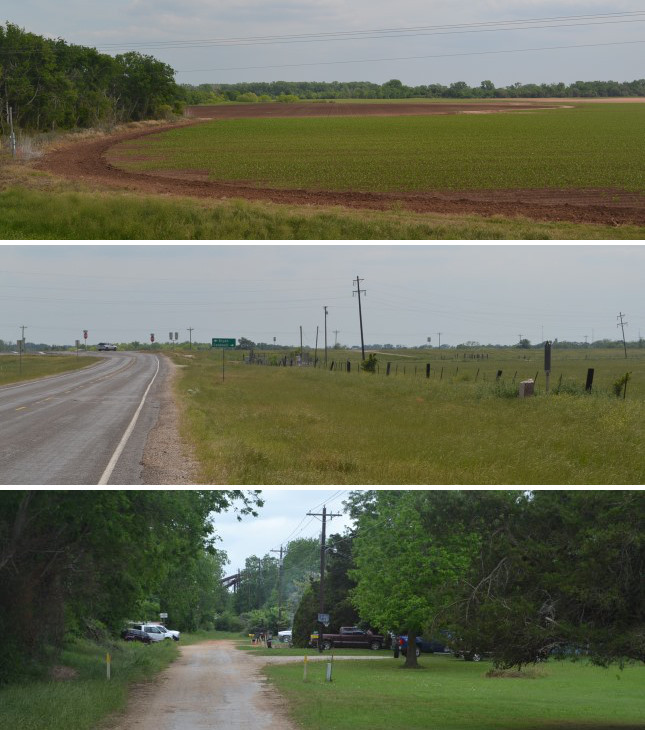
- About 0.8 miles north of the Brazos River, Zively drew a fork in the Old San Antonio Road. SH 21 approximates one fork for about 0.8 miles to the Brazos River. The other fork went west for about 1.8 miles and intersected the Brazos at a different point. That fork is now lost.
Bottom: Site of OSR Marker #46.
State Highway OSR
Highway OSR follows the Brazos-Robertson County line until 0.2 miles southwest of Highway 6. At that point, the county line breaks in a straight line toward the Brazos River. Highway OSR, following the historic Old San Antonio Road, runs south-southwest into western Brazos County.
The original Texas State Highway OSR, completed in 1936, started at Midway in Madison County and ended at Highway 6 near Benchley. The section in Brazos County between Highway 6 and Highway 21 was completed in 1942. According to a map from 1957, Highway OSR originally had a complicated route through Benchley using a road now known as 231 Spur and a part of Old Hearne Road. That section has been straightened out since then.
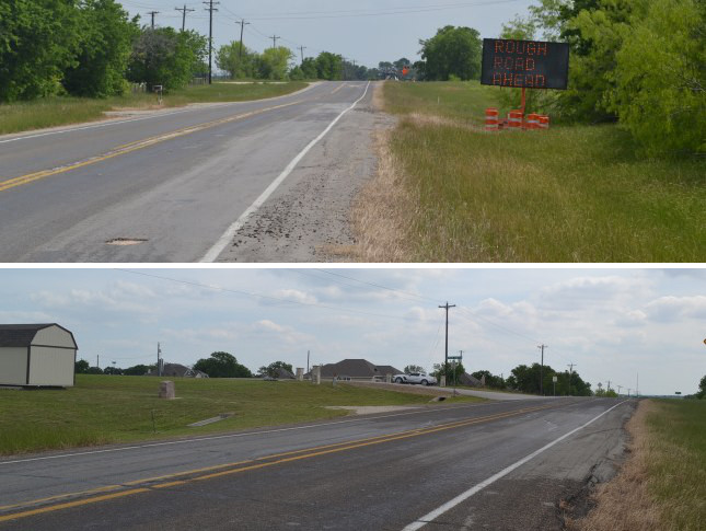
Today, this section of SH OSR is rough and worn. The road's condition is especially poor - marred with holes, abrasions, and patchwork repairs - the first few miles after Highway 6.
Zively placed his survey post for OSR Marker #46 south of present-day Sandy Point Road/FM 1687. It has since been moved about 0.6 miles closer to Highway 6.
Middle: Site of OSR Marker #47.
Bottom: The end of Varisco Lane, where Stone City once was. Note the rail bridge over the Brazos River in the background.
The Road Divides
Just before SH OSR intersects with Highway 21, it begins to turn from an almost north-south direction to more of a southwesterly one. After the intersection, Highway 21 then proceeds in an almost east-west path for about a mile and a half. The historic Old San Antonio Road as surveyed by Zively in 1915 took a similar turn from north-south to east-west, but the route Zively surveyed was somewhat to the south of today's Highway 21. Zively's route is no longer visible. He placed his survey post for OSR Marker #47 on the west bank of the Little Brazos River at a place he labeled "Old Rock Ford." It would have been south of present-day Highway 21 by perhaps 500 to 1,000 feet.
Highway 21 begins curving southward again at Cash Road. It then curves even more sharply and crosses the Brazos River in an almost north-south line. In this area, approximately where Highway 21 crosses Cash Road, Zively did something unique: he began plotting and surveying two different routes of the Old San Antonio Road. One route turned south to cross the Brazos River, like Highway 21 does, only it made a sharp turn, rather a wide curve, like the modern highway does. The other route continued nearly straight west and crossed the Brazos about 1.5 miles west of where Highway 21 does now. That route is now entirely lost. This longer, more westerly route is the one Zively labeled "The Kings Highway." The two routes stayed separated for 5 miles, not rejoining until Cooks Point in Burleson County. While there are several other places on his sketches where Zively showed a "Road Now Used" in the same area as "The Kings Highway," this is the only place where he did a complete survey of both routes.
The historical evidence for the more westerly, no-longer-extant route that Zively labeled "The Kings Highway" is abundant. Crossing the Brazos River at Shoal's Ford near Tenoxtitlan, it is the only route shown on maps or described in records up to the mid-1800s. The second route appears to have arisen after the founding of Boonville, north of present-day Bryan, in 1841. A ferry was set up at the current Highway 21 crossing in the late 1840s, and a road from Boonville to Caldwell begins to appear on maps from the early 1850's. The old route began to disappear from maps by the early 1900s. Highway 21 was built over the Boonville road between 1917 and 1919. The old route does not appear on any maps from 1919 on. These routes, their river crossings, and their history are discussed in more detail on our tour page for Burleson County.
A town named Stone City once existed on the north bank of the Brazos River at the ferry crossing where Highway 21 is now. In 1914, the year before Zively made his visit, Stone City had 32 residents, a post office, a grocery store, a general store, and a dry goods store. The town apparently declined after the bridge for Highway 21 was built. Its post office was closed in 1919. It reportedly still had a church in 1988. In 2014, all that was at the site were a few dwellings among the trees.
Page last updated: May 19, 2014
- Zively, V.N. - "Field Notes and Detail Map of the Kings Highway", 1916
- Carson, David - field notes observed and recorded in 2014
- Texas State Historical Association - The Handbook of Texas Online