
The Old San Antonio Road in Lee County
The Old San Antonio Road in Lee County
- Map of the Old San Antonio Road in Lee County
- Route Details
- SH 21 East of US 77
- Lincoln Area
- SH 21 West of US 77
The Old San Antonio Road passes through the middle of Lee County from northeast to southwest. Small communities like Old Dime Box, Lincoln, and Manheim are the only population centers in this rural area. There are numerous cattle farms along the road, plus some farms where horses or goats are raised. Oil fields are seen in the northeast, while corn fields are seen in the southwest.
Highway 21 follows Zively's route exactly in most of the county, with the largest divergence being around US Highway 77 and Lincoln.
Map of the Old San Antonio Road in Lee County
[-]Collapse Map [+]Expand Map
Route Details
- State Highway 21 from East Yegua Creek, which is the Burleson-Lee County line, for 8.8 miles to the eastern intersection of County Road 440. SH 21 has four lanes, divided by a median, and with both inside and outside shoulders as it crosses over from Burleson County. A little ways past the East Yegua Creek bridge, it reduces to four undivided lanes, with shoulders too narrow to stop on. It has these characteristics throughout Lee County, except at a few places where a center turning lane exists. The section of SH 21 from East Yegua Creek to CR 440 has an exact conformance to Zively's route.
- CR 440 from its eastern intersection with SH 21 for 1.0 miles to its western intersection with Highway 21. This is a dirt road. Exact conformance.
- SH 21 from the western intersection of CR 440 for about 0.6 miles. At about 0.2 miles northeast of CR 454, SH 21 diverges from Zively's route.
- Route lost from a point on SH 21 about 0.2 miles northeast of CR 454 for 0.8 miles to the bend in CR 327 near US Highway 77.
- CR 327 from its bend near Highway 77 for 0.2 miles to its turn. The north-south section of CR 327 between CR 327 E and CR 327 W is the section that is on Zively's route. It is a one-lane paved road in fair condition.
- Route lost from the turn at CR 327/CR 327 W for approximately 1.6 miles to a point on Highway 21 approximately 0.2 miles northeast of Farm-to-Market Road 1624.
- SH 21 from approximately 0.2 miles northeast of FM 1624 for 7.9 miles to the Bastrop-Lee County line. Exact conformance.
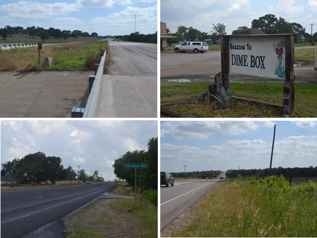
Bottom (l to r): Old Dime Box signpost; site of OSR Marker #56.
SH 21 East of US 77
The Old San Antonio Road enters Lee County on State Highway 21 at East Yegua (YEH-wa) Creek, which is the boundary between Burleson and Lee Counties. OSR Marker #55 is on the Lee County side of the creek.
A few miles inside of Lee County are two communities with peculiar names: Dime Box and Old Dime Box. The first community named Dime Box began as a sawmill built by Joseph S. Brown on the Old San Antonio Road after the Civil War. The mill attracted settlers, who named their community, appropriately, Brown's Mill. The first school opened in Brown's Mill in January 1874. Until a U.S. post office was established there in 1877, residents deposited their outgoing mail along with a dime in a small box in Brown's office for weekly delivery to Giddings. In 1884, postal authorities told Brown's Mill to change its name because its mail kept getting mixed up with Brownsville's. The town chose the name Dime Box after their old method of sending mail. Dime Box had a population of 127 in 1904.
In 1913, the Southern Pacific Railroad built a line about 3 miles south of the Old San Antonio Road and put in a station near Dime Box. Most of Dime Box's residents moved to the new station and established a new town, which they called New Dime Box. The original settlement thus became Old Dime Box. Before long, the word "New" was dropped from the new town. Dime Box had an estimated population of 500 in 1925. It has since declined to about 300, but it still has a bank, a high school, and several stores and churches. Old Dime Box is now a tiny rural community with one church and a few homes and businesses.
About 0.3 miles southwest of Old Dime Box, Zively placed the survey post for OSR Marker #56. He noted that it was at the "N.W. Corner S.F. Austin's Five League Survey." This marked a corner of a parcel of land that empresario Stephen F. Austin received as part of his contract with Spain to bring families into Texas. This parcel was bounded on the northwest by the Old San Antonio Road. Lee County Road 430 now makes up the southwestern boundary of this parcel. The northeastern boundary is now Burleson County Road 130, where Zively placed the survey post for OSR Marker #54.
Highway 21 continues to mark the Old San Antonio Road all the way to CR 440. Along the way, it crosses another branch of Yegua Creek, called Middle Yegua Creek or Second Yegua Creek. These two branches of Yegua Creek, along with a third branch further west, merge southeast of Dime Box, forming a single Yegua Creek that empties into Lake Somerville.
Maps from before 1930 indicate that Highway 21 was originally designated as running south of and parallel to the Southern Pacific railroad track that runs from Caldwell in Lee County through Dime Box to Giddings. Its current route along the Old San Antonio Road begins to appear on maps in 1930.
Lincoln Area
The current route of Highway 21 was apparently constructed in east Lee County in 1930 or 1931. It followed Zively's route of the Old San Antonio Road precisely for about the first nine miles, then it made its first diversion, in the form of a straight line that bypassed a bend in the historic road. The bypassed section still exists today as Lee County Road 440. Zively placed the survey post for OSR Marker #57 on this road. The matching granite marker stayed there for at least several decades, but it was eventually moved to Highway 21. Some homes and farms are on CR 440 today, including what may be the only goat pasture on the Old San Antonio Road. There is a small family cemetery at the west end of the road.
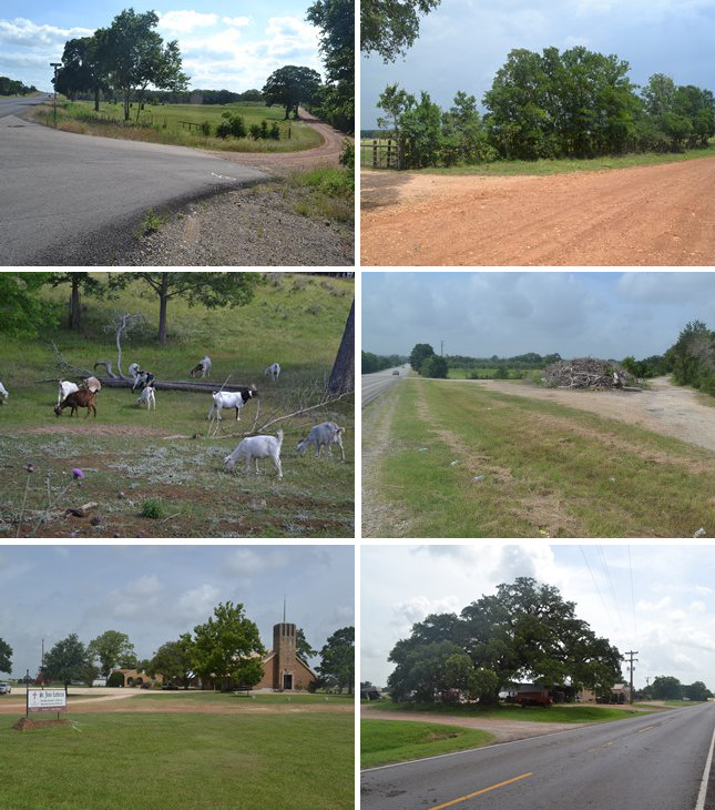
Middle (l to r): Goat pasture on CR 440; CR 327 at US Highway 77 (Zively's route is on the far right of the photo.)
Bottom (l to r): St. John Lutheran Church; the old evergreen tree.
West of CR 440, Highway 21 resumes the route of the Old San Antonio Road for less than a mile. It then makes a substantial diversion from Zively's route in the vicinity of Lincoln.
Settlers began arriving in the vicinity of West Yegua Creek before the Civil War. The town of Evergreen began as a stage stop near the Old San Antonio Road at present-day FM 1624. The townsite was surveyed in 1856. It was named Evergreen after a large, prominent live oak tree that is said to have sheltered Louis de St Denis when he traveled along El Camino Real in 1713.
Evergreen is best known as the home of notorious murderer Bill Longley, whose family helped settle Evergreen. In 1866, at the age of fourteen, Longley is said to have killed a black man who cursed his father. He victimized other people in Lee County and the surrounding area - generally blacks, and usually over some kind of verbal offense - before he was forced to flee and live the life of a vagabond outlaw. He was captured in Louisiana in 1877. He was returned to Lee County and convicted of the 1875 murder of his childhood friend, Wilson Anderson. He was hanged in Giddings in October 1878. He claimed to have killed 32 people.
A few years after Evergreen was founded, another community arose a few years later about a mile north, on the bank of West Yegua Creek. When a U.S. post office opened in that town in 1886, the townspeople chose the name Lincoln, after a popular circuit-riding preacher named John A. Lincoln, who moved to Evergreen in 1879.
German settlers came to in Lee County in the late 19th century. One group settled west of Evergreen and south of Lincoln and founded St. John Lutheran Church in 1886. The church endured the deaths of fourteen infant children due to illness in 1888; their graves were among the first ones placed in the church's cemetery.
The towns of Evergreen and Lincoln prospered side-by-side for a few years, but as has happened at other places on the Old San Antonio Road - such as at Dime Box - local events were shaped profoundly by the railroads. In 1890, the San Antonio & Aransas Pass Railroad put in a line from Yoakum to Waco that went through Lincoln. This new line connected Lincoln with Giddings to the south and Lexington to the north. Most of the residents of Evergreen moved to Lincoln within a few years. Lincoln, with two cotton gins, a corn mill, and a saw mill, became a commercial hub for the area. It was probably at this time that the route of the Old San Antonio Road shifted to the west so as to go directly through Lincoln. The historic route that Zively surveyed became largely abandoned, and parts of it began to disappear.
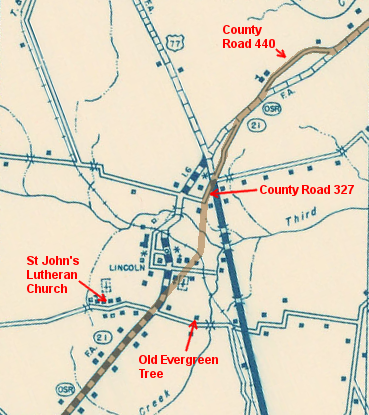
The San Antonio & Aransas Pass railroad went into bankruptcy in 1890, the same year it opened through Lincoln. It was bought by the Southern Pacific company, and the line remained operational for several decades. Lincoln grew from a population of 148 in 1904 to 200 in 1925, and 350 in 1940. As mentioned earlier, State Highway 21 was built through in 1930 or 1931. A section of a 1940 map of Lee County presented at right shows the relationship between Lincoln, Highway 21, and the sections of Zively's route of the Old San Antonio Road that still existed at that time. The path of the railroad track, which no longer exists today, can also be seen on the map.
Lincoln began to decline after World War II. Southern Pacific's decision to downgrade the former San Antonio & Aransas Pass system may have been a factor in this decline. In 1959, the section of the railroad through Lincoln was abandoned altogether. The tracks no longer appear on a 1961 version of the same map presented at right. Lincoln's population has been under 300 since about 1970. The most modern part of Lincoln is St. John Lutheran Church, which meets in a sanctuary built in 1960 and other structures completed more recently. A state historical marker sign was erected there in 1986.
Even less of Zively's route of the Old San Antonio Road exists at Lincoln today than the 1940 map depicts. Today, a 0.2-mile-long section of CR 327 is the only part of Zively's route that still exists as a public road.
All that is left of Evergreen is a cemetery and the tree that gave the town its name. A state historical marker sign was erected under the tree in 1967.
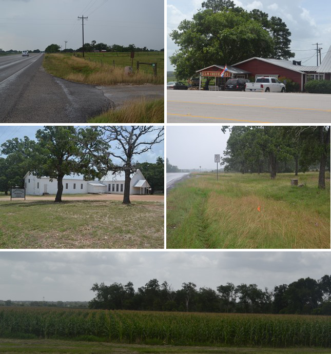
Middle (l to r): Manheim Parish Hall in Manheim; site of OSR Marker #59.
Bottom: Corn field in southwestern Lee County.
SH 21 West of US 77
At approximately FM 1624 south of Lincoln, Highway 21 resumes Zively's route of the Old San Antonio Road. Highway 21 follows Zively's route precisely for almost 8 miles to the Bastrop-Lee County Line.
OSR Marker #58 is at its original location, about a mile southwest of FM 1624.
Many towns on the Old San Antonio Road began as places for early 19th-century travelers to stop, eat, and rest. While a lot has changed about highway travel in the last two hundred years, one thing that hasn't changed is that people need places to stop and eat. The Elm Creek Cafe, on Highway 21 at Elm Creek, about 5 miles southwest of Lincoln, is the only full-service restaurant in Lee County on Highway 21. It has been serving southern favorites like catfish, chicken fried steak, and homemade pie to hungry travelers since at least the 1970s.
Zively noted the town of Manheim on his survey of the Old San Antonio Road approximately at the intersection of present-day FM 2440. This community was settled by German immigrants and was probably named after Mannheim, Germany. A post office opened there in 1900. The town started off with one store and a school. The population in 1914 was estimated at 50. It has been between 30 and 40 for most of its history since then.
Zively placed the survey post for OSR Marker #59 about a mile west of Manheim. It was subsequently moved to some land near Manheim that that was donated to the state for park purposes in 1936. The marker was displayed in a state-maintained picnic area until about 2011, when the state removed the picnic tables and litter barrels and tore out the asphalt driveway. The marker remains at the site, which has recently become overgrown with weeds.
The Old San Antonio Road apparently ceased to be a significant highway in this area before the end of the 19th century. It does not appear on Texas maps from 1900 through 1929. The first state map showing a state highway between Lincoln and Paige is dated 1930. A 1933 map produced by the Texas Highway Department designates it as State Highway OSR. Few commercially-produced maps from the 1930s show this road at all, and those that do label it as Highway 21. The 1940 Lee County map excerpted above, also produced by the state highway department, designates it as both SH 21 and SH OSR. The OSR designation appears to have been dropped completely in the early 1940s.
Page last updated: January 12, 2015
- Zively, V.N. - "Field Notes and Detail Map of the Kings Highway", 1916
- Carson, David - field notes observed and recorded in 2014
- Texas State Historical Association - The Handbook of Texas Online
- Zelade, Richard - Lone Star Travel Guide to Central Texas, Taylor Trade Publications, 2011