
The Old San Antonio Road in West Bastrop County
The Old San Antonio Road in West Bastrop County
- Map of the Old San Antonio Road in West Bastrop County
- Route Details
- West of Bastrop
- Union Chapel Road and Mt. Olive Road
- SH 21 to Caldwell County
The route of the Old San Antonio Road has been preserved fairly well in western Bastrop County. Near the city of Bastrop, where there has been more highway construction, the Kings Highway skips around between various state and local roads. In the rural western part of the county, it follows State Highway 21/71, except for a few places where the modern highway has been straightened.
Thanks to its proximity to the rapidly-growing city of Austin, western Bastrop County has seen its own share of development and growth since the late 1980s and early 1990s. The city of Bastrop now occupies both sides of the Colorado River. Further out is the community of Wyldwood, where the OSR and Highway 21 branch off of the main highway to Austin, which is Highway 71. From Wyldwood to Caldwell County, the OSR passes through countryside that is less developed than that on the Austin-Bastrop corridor, but nevertheless is still under the influence of both cities.
Map of the Old San Antonio Road in West Bastrop County
[-]Collapse Map [+]Expand Map
Route Details
- Route lost from the Colorado River near the corner of Water Street and Jasper Street for 0.9 miles to Old Austin Highway just west of Grady Tuck Lane.
- Old Austin Highway from just west of Grady Truck Lane for 1.0 miles to its intersection with Highway 21. Old Austin Highway has two main lanes plus a center turning lane. It is curbed, with no shoulders. This segment has an exact conformance to Zively's route except at each end, where it intersects with Loop 150 and State Highway 21/71.
- SH 21/71 from the west end of Old Austin Highway for 3.8 miles to the point where it curves northeastward at Union Chapel Road. Exact conformance. East of SH 20, this is a limited-access freeway with four main lanes divided by a grass median, plus frontage roads on both sides. Around SH 20, the freeway ends, the frontage road on the north side goes away, and the frontage road on the south side becomes a two-way road. The highway has narrow inside shoulders and wide outside shoulders. It continues thusly until Marker #66, where the south frontage road ends.
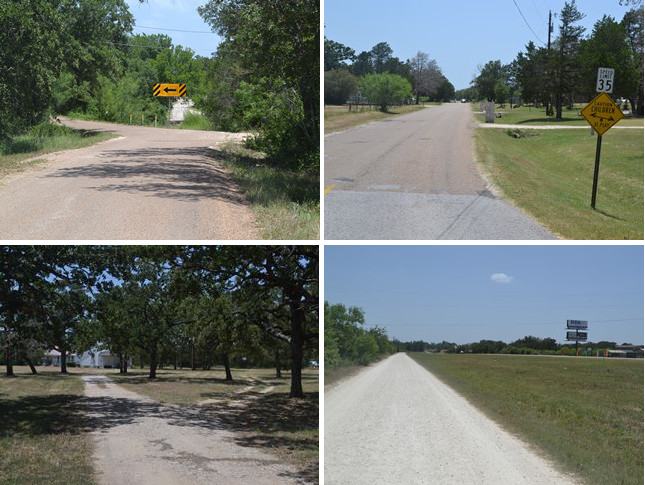
- Union Chapel Road from its east end at SH 21/71 for 0.6 miles to its west end at SH 21. This section conforms with Zively's route on the east end and in the middle, but it now goes straight through on the west end, whereas it originally curved around a hill. Union Chapel Road has one wide paved lane. The eastern half is of a poor quality and is closed to through traffic.
- Mt. Olive Road/CR 79 for its entire length of 2.6 miles. This road conforms exactly to Zively's route except at the ends, where the intersections with SH 21 have been altered. It has one wide paved lane east of Gaines Road/CR 81 and turns to a good-quality gravel surface west of Gaines Road.
- SH 21 from the west end of Mt. Olive Road/CR 79 for 11 miles to the Caldwell County line. Most of this segment conforms to Zively's route, but there are four places, totaling about 3.5 miles, where the road has been straightened and shortened. SH 21 has two undivided lanes with wide shoulders.
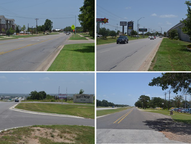
Bottom (l to r): Bastrop sign at the western city limits; site of OSR Marker #66.
West of Bastrop
The town of Bastrop was founded in 1832 on a bluff on the east bank of the Colorado River. The habitable area on the west side of the river was separated from the city by a flood plain about a quarter of a mile wide, so it remained lightly settled and undeveloped for the 19th and most of the 20th centuries. Thanks largely to the rapid growth of Austin about 30 miles away, however, Bastrop's population began to surge in the early 1990s, and the city limits were extended across the river. The west side of the river is now bustling with commercial development including hotels, automobile dealerships, banks, shopping centers, home improvement stores, auto repair shops, gyms, professional offices, and fast food restaurants. There are some residential developments near town on the west side of the river, plus some more further out into the western part of the county.
The route of the Old San Antonio Road that Zively surveyed showed the Kings Highway crossing the Colorado River at a ford near the mouth of Gills Branch creek south of Bastrop. The road then meandered up the west bank of the Colorado River to approximately where Old Austin Highway and Loop 150 intersect today. In about 1839, ferry service opened upriver of the Gills Branch ford. The first bridge at Chestnut Street opened in 1889. These improvements made the old ford obsolete, and Zively's route to it is now lost.
Zively's route resumes on the road now known as Old Austin Highway. This mile-long stretch of road has known many names - originally El Camino Real or the Old San Antonio Road, then State Highway 3‑A (from 1919 to 1926), State Highway 71 (1926-1959), and US Highway 290 (1935-1951). In 1959, a new freeway and bridge were on the south side of Bastrop, and Highway 71 was routed to it. This segment was retired as a state highway, but it remains in use as a well-maintained and highly-traveled city street.
At the west end of Old Austin Highway, present-day Highway 21/71 follows Zively's route - a straight, almost perfect east-west line - for 3.8 miles. This area, still mostly rural and undeveloped at this writing, will undoubtedly become either part of Bastrop or an incorporated town of its own in due time.
OSR Marker #66 is near an automobile dealership on the highway about 5 miles west of the river.
Bottom (l to r): Mt Olive Missionary Baptist Church; the west end of Mt Olive Road, paralleling Highway 21.
Union Chapel Road and Mt Olive Road
About five miles west of the Colorado River, Highway 21/71 turns to the northwest, separating from Zively's route, which continued straight west for about another half mile. This remant of Zively's route is known as Union Chapel Road. The easternmost section of this road is poorly maintained and is closed to through traffic.1 The middle section of Union Chapel Road is open and matches Zively's route.
Near the western intersection of Union Chapel Road and Highway 21, Zively noted a "Rough Hill," which the Old San Antonio Road curved around to the north of. Today there is no hill - it apparently has been leveled through generations of highway construction and land development - but it may have been significant enough to account for the humped, non-contiguous shape Highway 21 has in this location today. Today, Union Chapel Road goes straight through and intersects with Highway 21, which passes by the west side of the now non-existent hill.
No sooner does Zively's route return to Highway 21 than it departs from it again after only a few feet, taking another local road, Mt Olive Road. Also called Bastrop County Road 79, this road preserves Zively's route exactly for 2.5 miles.
Mt Olive Road was named after the Mt Olive Missionary Baptist Church, which built its first sanctuary here in 1909. The Mt Olive Evergreen Cemetery is a short distance away. The Mt Olive area is mostly residential, with a mixture of subdivisions and farm houses. It is considered to be part of the community of Cedar Creek.
At its west end, Mt Olive Road parallels Highway 21 for 0.2 miles. Mt Olive Road preserves Zively's route all the way to its intersection with Highway 21, which then takes over Zively's route.
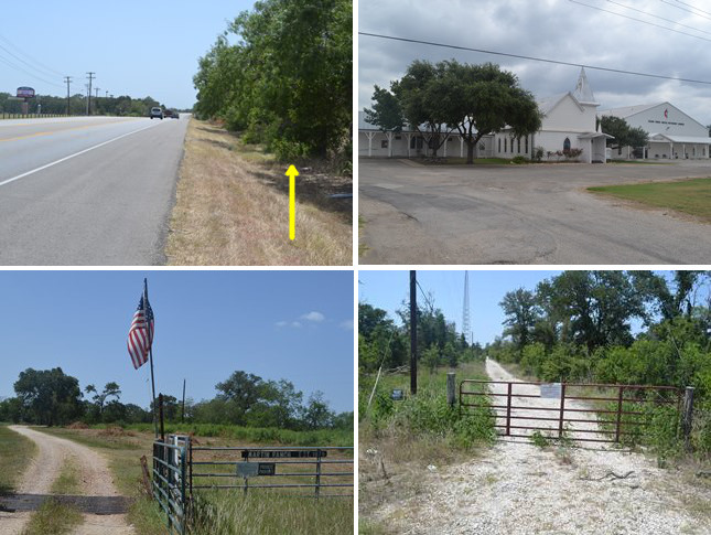
Bottom (l to r): Entrance to the Martin Ranch, established 1875; approximate location of the survey post for OSR Marker #68.
SH 21 to Caldwell County
Highway 21 follows Zively's route all the way from Mt Olive Road to the Caldwell County line. A few zig-zags in the Kings Highway have been straightened out, but otherwise, Highway 21 is faithful to Zively's route. This part of the county is not directly between Bastrop and Austin, so it has not seen the same amount of recent development that one sees along Highway 71, but there are nevertheless some recently-built subdivisions, plus others under construction.
OSR Marker #67 is between Mt Olive Road and the town of Cedar Creek. It is across the street from a football stadium belonging to the Bastrop school district.
The only organized community in western Bastrop County on Highway 21 is Cedar Creek. The first recorded community activity here is the founding of a Methodist church in 1842. Schools and other churches followed, and a post office was established in 1852. Cedar Creek's peak population was 600, in 1884. It then suffered a rapid decline, even despite the discovery of oil nearby in 1928. The population since at least the 1980s has varied between 145 and 200. Cedar Creek still has a post office. It also has four schools that are in the Bastrop Independent School District, whose boundaries extend all the way to the Travis and Caldwell County lines. The Methodist church still meets here; its campus includes a sanctuary built in 1910.
Bastrop County is sparsely populated west of Cedar Creek. Much of the land is uncleared and belongs to private family ranches and farms, such as the Martin Ranch, which was founded in 1875. There are few commercial farming, ranching, or drilling operations in this area.
OSR Marker #68 should be close to Highway 21 west of the Martin Ranch, but it has not been found.
Page last updated: August 11, 2014
1It is unclear from modern maps whether this section is still a public road at all. It was made clear during our field trip that visitors and tourists are not welcome to drive on it.
- Zively, V.N. - "Field Notes and Detail Map of the Kings Highway", 1916
- Carson, David - field notes observed and recorded in 2014
- Texas State Historical Association - The Handbook of Texas Online