
The Old San Antonio Road in Hays and Caldwell Counties
The Old San Antonio Road in Hays and Caldwell Counties
- Map of the Old San Antonio Road in Hays and Caldwell Counties
- Route Details
- SH 21 / Niederwald
- Old Spanish Trail / Uhland
- SH 21 / Rural San Marcos
- Old Bastrop Highway - County Line
- Old Bastrop Highway - Hays County
The Old San Antonio Road was set as the boundary between Caldwell and Hays Counties in 1848. Its use as a county line here goes back to 1837, when Bastrop County was on the north side, and Gonzales County was on the south side. When State Highway 21 was built through in the early 1940s,1 it followed the historic route in most places, but a few small changes were made. Wherever the route was changed, Highway 21 now lies inside one county or the other. The historic route is preserved alongside Highway 21 in some places, most notably around the town of Uhland, where Zively's route was preserved as "Old Spanish Trail."
Highway 21 does not follow the last two miles of the Hays-Caldwell County line. The Old Bastrop Highway preserves the Old San Antonio Road for this stretch.
The Caldwell-Hays County line stops at the San Marcos River. There, the Old San Antonio Road continues on as Old Bastrop Highway, but it is fully within Hays County.
This area - nestled between and weaving around the cities of Austin, San Marcos, Kyle, and Lockhart - is still mostly rural, but it is by no means remote, as no part of it is more than fifteen minutes from a large town or from busy Interstate Highway 35.
Map of the Old San Antonio Road in Hays and Caldwell Counties
[-]Collapse Map [+]Expand Map
Route Details
- State Highway 21 from the point where it becomes the county line for 2.8 miles to Farm-to-Market Road 2001 South and Hays County Road 126. SH 21 conforms exactly with the OSR in this section. It has two undivided lanes with narrow shoulders.
- Rohde Road / Hays CR 126 from Highway 21 for 0.1 miles straight west, until it turns northwest. Rohde Road is a two-lane, unstriped blacktop road.
- No road for from Rohde Road for 1.5 miles on the north side of SH 21 until the route rejoins SH 21 at Brushy Creek. The route, which is the Caldwell-Hays County line, is highly visible on aerial photos, and property fences along the old roadbed mark the route on the ground.
- SH 21 from Brushy Creek for 1.0 miles to Old Spanish Trail east of Uhland.
- Old Spanish Trail for its full length of 2.7 miles through Uhland. This road preserves Zively's route exactly. Although this 2-lane road is paved, it is very bumpy.
- SH 21 at Old Spanish Trail west of Uhland for 6.9 miles to the entrance to the Quail Creek Golf Club. The highway has two undivided lanes, which increase to four plus a center turning lane at the outskirts of San Marcos.
- Route lost from SH 21 at the entrance to the Quail Creek Golf Club for 0.2 miles to the north end of Old Bastrop Highway.
- Old Bastrop Highway from its north end at the railroad track (not including the short, east-west section that connects with SH 21) for 10.4 miles to the Comal-Hays County line. Parts of this road are also known as Hays CR 266 or Caldwell CR 101. It preserves Zively's route for its entire length, except for about a 1-mile stretch in the vicinity of SH 123 and San Marcos High School. Most of the road is two-lane, undivided, with no shoulders. From Centerpoint Road to Frances Harris Lane in southwestern Hays County, the Old Bastrop Highway has shoulders. Approximately at Frances Harris Lane, the road's surface turns to gravel and remains so until the Comal County line.
Bottom (l to r): This fence and the raised bed mark the Caldwell-Hays County line and the old OSR route in the vicinity of OSR Marker #71; site of OSR Marker #71.
SH 21 / Niederwald
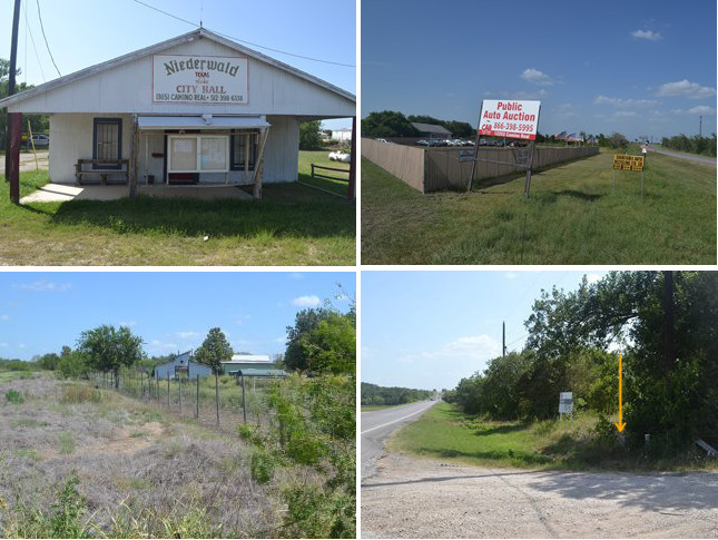
The town of Niederwald is at the northeastern end of the Caldwell-Hays County line. It was settled on the Hays County side of the Old San Antonio Road by German pioneers after the Civil War; the name means "brushwood" in German. A public school was built in 1877. A post office was established between 1902 and 1904, and a church was established in 1906. The town had a population of 100 in 1930. Afterward, there was a slow decline. The church closed some time after the 1940s. By the early 1960s, the town had no businesses. Niederwald began its second life in the 1990s, with a population of 233 in 1990 and 584 in 2000. It now includes territory in Caldwell County.
Vehicles that have been salvaged by insurance companies after theft or total loss are typically sold at auction, as are vehicles donated to charities. A number of automobile auction companies are set up on Highway 21 from western Bastrop County into northeastern Hays County. The auction pictured at right is southwest of Niederwald.
Highway 21 follows the Old San Antonio Road exactly as a straight line from the northeastern end of the county line through Niederwald. Southwest of Niederwald, the Old San Antonio Road becomes crooked. Highway 21 smooths out this section, staying slightly on the Caldwell County side of the line. The first tenth of a mile of the old road is paved as Rohde Road, or Hays County Road 126. The remainder of the old, crooked route is now gone, but parts of the old roadbed are still visible, and property fences are maintained on it. OSR Marker #71 was originally placed along this section, but it is now on Highway 21.
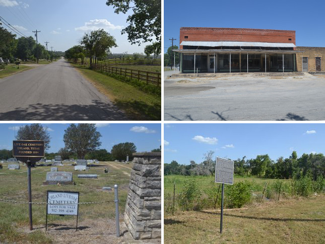
Bottom (l to r): Live Oak Cemetery; sign commemorating the Comanche Raid of 1840.
Old Spanish Trail / Uhland
German settlers arrived in the 1860s and established a village on the Old San Antonio Road at Plum Creek. The town was originally called Live Oak. The St John United Church of Christ was founded there in 1889. The Schiwitz General Store was operating by 1892. The earliest grave at the Live Oak Cemetery is dated 1895.
In 1900, a post office was opened. The community at that time decided to name itself after the late German poet Ludwig Uhland (1787-1862). By 1910, a cotton gin and a blacksmith/mechanic shop had opened. Uhland's population in 1950 was 140.
Highway 21 bypassed Uhland in the 1940s, but the historic Old San Antonio Road was left behind to serve as the city's main street, now known as Old Spanish Trail.
The Schiwitz General Store was operated by the founder's granddaughter up until her retirement in 1978. It closed a few years later. The building, now vacant, still stands on Old Spanish Trail. The old schoolhouse now serves as the city hall and community center. Uhland has two churches - the original St John Church, now in a modern sanctuary on Highway 21, and St Michael's Catholic Church, next to the Live Oak Cemetery on Old Spanish Trail. Uhland has a total of nine business, including a diner which is the only restaurant on Highway 21 between Bastrop and San Marcos. The town's population was 386 in 2000.
A metal sign at the crossing of Old Spanish Trail and Plum Creek commemorates the Great Comanche Raid of 1840. On 4 August of that year, hundreds of Comanche Indians launched a raid in Texas in retaliation for an earlier conflict in San Antonio known as the Council House Fight. The raiding party crossed the Old San Antonio Road at Plum Creek, where this sign is located. The Comanches razed the towns of Linnville and Victoria on the Gulf Coast, then began making their way back to their home in western central Texas. Weighed down by their plunder, they were defeated by a group of Texas Rangers near present-day Lockhart. Although the sign posted here is similar in appearance to the familiar metal historical marker signs placed by the Texas Historical Commission, it does not bear the commission's name or seal, and does not have any markings to indicate who placed it here, or when.
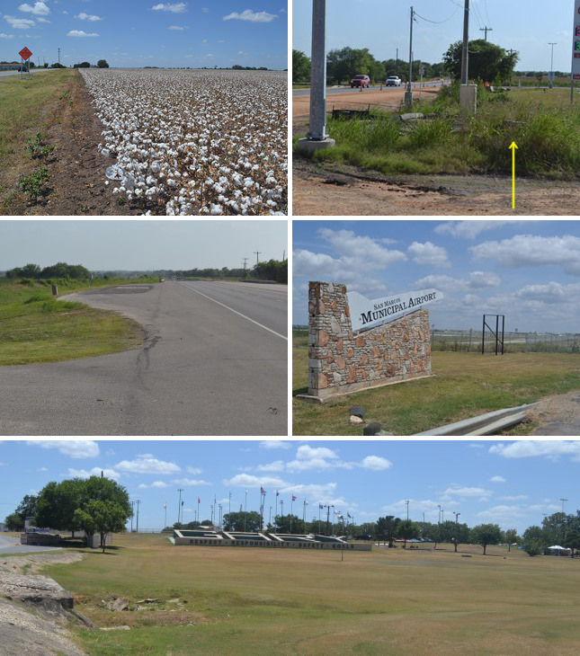
Middle (l to r): Site of OSR Marker #73; entrance to San Marcos Municipal Airport.
Bottom: Front lawn of the Gary Job Corps. The trees to the right (southwest) are in Gary Park. Further southwest is the Gary Softball Complex.
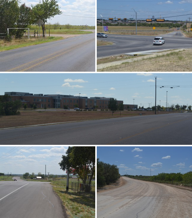
SH 21 / Rural San Marcos
Outside of Uhland, Highway 21 resumes its dual role as preserver of the route of the Old San Antonio Road and marker of the Caldwell-Hays County line. The area closest to Uhland is largely devoted to growing corn, cotton, and other crops. Highway 21 still has two undivided lanes in this agricultural area.
Hays County Road 150, about 7 miles northeast of San Marcos, provides access to Interstate Highway 35 and the city of Kyle, which is about 5 miles to the northwest. The intersection of SH 21 and CR 150 was being widened in 2014. This is the location of OSR Marker #72.
The airfield that currently serves as San Marcos Municipal Airport was built on the Caldwell County side of Highway 21 during World War II. First opened in 1943, it was named San Marcos Army Airfield and was a navigator training facility during the war. After the war, helicopter training was performed there. It was renamed San Marcos Air Force Base in 1951 and Gary Air Force Base in 1953 after Lieutenant Edward Gary, the first soldier from Hays County killed in World War II. In 1956, the field was transferred from the Air Force to the Army and was renamed Camp Gary. It was closed as a military post in 1963. The following year, a section of Camp Gary was repurposed as a Job Corps facility. A city park and softball complex were built on a section adjacent to the Job Corps facility. The remainder of Camp Gary became the San Marcos Municipal Airport, a general aviation airport that saw an average of 326 aircraft operations per day in 2008.
OSR Marker #73 is in front of an office building at the north end of the airport.
Highway 21 follows Zively's route as far as the softball complex and golf course southwest of the airport. About 0.2 miles shy of the railroad track, Zively's route turns south, while SH 21 continues on southwest and then terminates in San Marcos. Zively's route is briefly lost before it is picked up on the other side of the railroad by the Old Bastrop Highway.
For twelve counties and nearly 300 miles in east and central Texas, State Highway 21 serves as the main home of the Old San Antonio Road. Although its faithfulness to the historic route is not perfect, it nevertheless does an outstanding job of preserving the legacy of El Camino Real in one long, contiguous stretch of pavement. Here, however, on the outskirts San Marcos, Highway 21's role as the preserver of the Old San Antonio Road is handed off to other roads and highways.
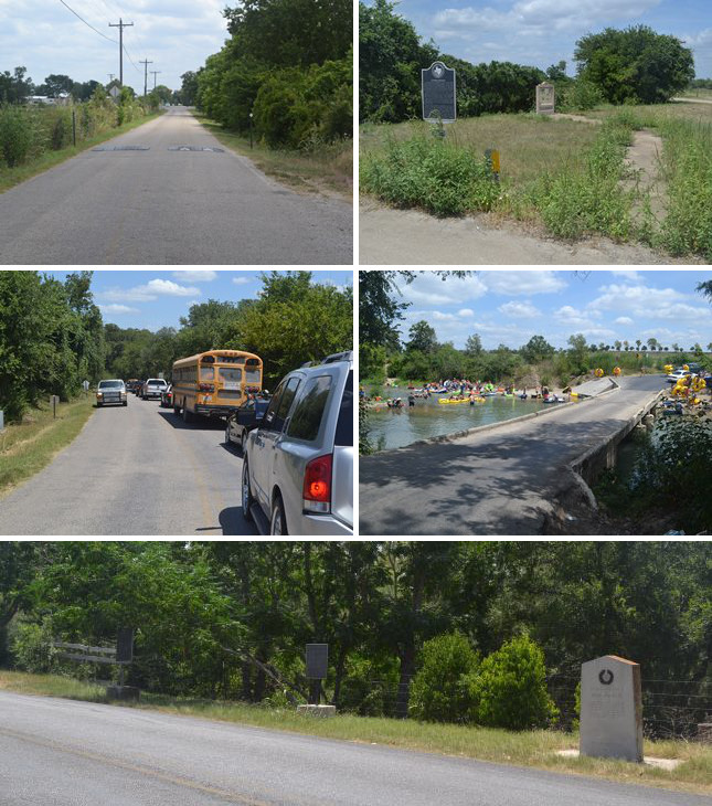
Middle: Motorists wait patiently in line for their turn to cross the one-lane bridge over the San Marcos River. River outfitters bring inner tubers in buses to put in at the river here. The shallow, calm water at the McGehee Crossing makes an ideal spot to begin a summer afternoon of floating down the river.
Bottom: Three historical markers on the south bank of the San Marcos River. OSR Marker #74 was originally placed at or near this location.
Old Bastrop Highway - County Line
The road that preserves Zively's route of the Old San Antonio Road for the last two miles of the Caldwell-Hays County line is known today as Old Bastrop Highway. Parts of it are maintained as Hays County Road 266 and/or Caldwell County Road 101.2 It is a two-lane, undivided paved road. At the time of our visits, the striping was barely visible, and the surface was rough in many places.
Disregarding the short east-west section of CR 266 that connects Old Bastrop Highway to Highway 21, the road begins at the railroad tracks on the south side of the Gary Softball Complex. After about a mile, it crosses State Highway 80. After about another mile, it crosses the San Marcos River. There, the Caldwell-Hays County line turns to follow the river. Old Bastrop Highway continues on, but south of the river, it is fully within Hays County.
The OSR crosses the San Marcos River at a natural ford. In 1807, with concerns about Americans illegally immigrating into Texas from the new U.S. territory of Louisiana, the Spanish government authorized the establishment of a colony at this crossing. A small group of settlers led by Don Felipe Roque de la Portilla arrived on 6 January 1808 and founded the village of San Marcos de Neve. After Portilla brought in a second group that autumn, their numbers were up to 73. The primary occupation of the villagers was ranching. The settlement failed due to frequent native raids and inadequate support from the government. It was abandoned in 1812.
This favorable site was not settled again during the periods of Spanish or Mexican colonization of Texas. In 1846, when Texas was part of the United States, a group of Anglo settlers arrived to claim their grants. The new town of San Marcos was founded at the river's headwaters, about five miles upriver of the Old San Antonio Road. Thomas G. McGehee settled on the east side of the river, and in 1859, his nephew, Charles L. McGehee Jr., acquired the land where the road crossed the river. This crossing became known as the McGehee Crossing.
Today, there is a one-lane, concrete, low-water bridge at the McGehee Crossing. The ford is still there also, and in the summer months, it is a popular put-in spot for people who come to enjoy a day of floating down the river on inner tubes.
A state historical marker sign commemorating the McGehee Crossing has been placed at the intersection of Old Bastrop Highway and Highway 80. An Old San Antonio Road informational poster was added to the site in 1991.
Three more historical markers have been placed near each other on the south or west bank of the river. A granite marker for San Marcos de Neve placed in 1936 and a metal historical marker sign for Don Felipe Roque de la Portilla placed in 1976 commemorate Spain's original attempt to settle this site. The third marker is for American explorer Zebulon Pike, who crossed the San Marcos River at this location on 14 June 1807 while being escorted back to the United States by Spanish authorities. V.N. Zively also placed his survey post for OSR Marker #74 at or close to this spot, but the matching pink granite marker is now almost a mile and a half from the river, inside Hays County.
Middle: San Marcos High School
Bottom (l to r): Site of OSR Marker #75; Old Bastrop Highway's change to a gravel surface near the Comal-Hays County line.
Old Bastrop Highway - Hays County
Old Bastrop Highway passes through southwest Hays County for about 8.5 miles between the San Marcos River and the Comal-Hays County line. The land along the road is mostly cleared. There aren't many crop fields or large agricultural interests here; there are mainly country homes and ranches, plus some new subdivisions and other signs of suburban development in the parts closer to San Marcos. "Old Bastrop Highway" is the preferred name of this road all the way from the San Marcos River to the Comal-Hays County line, but there are a few CR 266 signs here and there, and at least one sign that reads "Old Bastrop Road," which is the road's name in Comal County.
OSR Marker #74 is at the intersection of Old Bastrop Highway and Staples Road.
Travel on the Old Bastrop Highway is interrupted at State Highway 123. Travelers driving southwest on the highway are diverted onto McCarty Lane, while travelers driving northeast on Old Bastrop Highway reach a dead end. Either way, travelers wishing to continue along Old Bastrop Highway must make a short detour onto Highway 123.
On the west side of Highway 123, the Old Bastrop Highway departs from the OSR for about a mile. San Marcos High School now sits atop the historic route.
OSR Marker #75 is about three miles east of the Comal County line. This is at the city limits of San Marcos.
The last mile of the Old Bastrop Highway in Hays County has a gravel surface.
Page last updated: August 30, 2014
1This section of Highway 21 was originally designated as Texas State Highway OSR.
2The only CR 266 sign is at the road's intersection with Highway 21; this may refer only to the short east-west connector and not the historic road. There are CR 101 signs at various places, and an "Old Bastrop Hwy" sign at the SH 80 crossing. Contrary to the labeling on some maps, there are no signs reading SH 21 or "Old Bastrop Road" on this segment of the Old Bastrop Highway.
- Zively, V.N. - "Field Notes and Detail Map of the Kings Highway", 1916
- Carson, David - field notes observed and recorded in 2014
- Texas State Historical Association - The Handbook of Texas Online
- City of Uhland - "History of Uhland", 2012