
The Old San Antonio Road in Central Dimmit County
The Old San Antonio Road in Central Dimmit County
Also see The Old San Antonio Road Posts and Markers in Central Dimmit CountyThe Old San Antonio Road went west-southwest from Catarina through south-central Dimmit County. There are no towns between Catarina and the Rio Grande. The historic route is almost entirely on private property, and only traces of it remain evident.
Map of the Old San Antonio Road in Central Dimmit County
[-]Collapse Map [+]Expand Map
Route Details
- Route lost from the western city limits of Catarina on Cemetery Rd for 10.0 miles to the original location of OSR Marker #121 on the Briscoe Catarina Ranch.
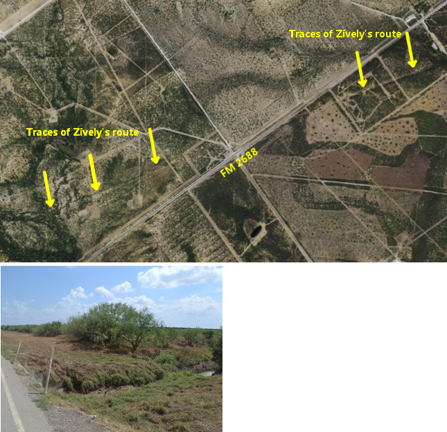
Bottom: Catarina Creek at FM 2688.
The Briscoe Catarina Ranch
The area southwest of the town of Catarina was part of the 224,000-acre Catarina Ranch that was purchased in 1881 by Ohio iron magnate David Sinton. (For more information about the Sinton ranch, see our tour page on East Dimmit County). The Sinton family sold the ranch in 1920, and the new owners began subdividing the 350-square-mile property. In 1938 or 1939, rancher Dolph Briscoe Sr. purchased 35,000 acres. Briscoe expanded the ranch through additional purchases to 100,000 acres by the time of his death in 1954. Briscoe's son, Dolph Jr. - who was Texas' governor from 1973 to 1979 - took over the Briscoe Catarina ranch upon his father's death. It is currently owned by his son, Dolph Briscoe III, who is also known as Chip Briscoe. The Briscoe Catarina Ranch raises cattle and is used for commercial deer hunting and oil operations.
The Kings Highway as surveyed by Zively in 1915 passes along the south side of Catarina, then turns west-southwest and passes through the Briscoe Catarina Ranch in mostly a straight line.
OSR Marker #119 was placed five miles from Catarina.
About 1.5 miles further on, Zively's route crosses Farm-to-Market Road 2688 at approximately a 15-degree angle. This road already existed when Zively made his survey in 1915, as he noted:
The Kings Highway has been nearly obliterated by a new Road - a very broad Right of way has been cleared of brush and Prickly pear and the road-bed is graded 60 ft wide. Just occasionally the old Road can be seen first on one side and then on the other of the recent grade.
Logically, the above note ought to have been made on the page of Zively's sketchbook showing the section between Markers #119 and #120, where the two roads crossed, but instead it is found on the page showing the section between Markers #118 and #119. Despite this discrepancy, there is no question that FM 2688 is the "new Road" Zively wrote about, for it was one of the first paved roads in Dimmit County, and there are no other possible candidates.
About 0.8 miles southwest of the road intersection described above, the Kings Highway crossed Catarina Creek. Friar Juan Morfi stopped at this stream in his 1778 journey along El Camino Real. In his diary, he referred to it as Santa Catarina, or "Saint Catherine." It was very common for the Spaniards to name creeks, springs, and other geographic discoveries after a saint when the place was discovered on that saint's feast day on the Roman Catholic calendar. This probably means that this creek was discovered on November 25, the feast day of Saint Catherine of Alexandria.1 This creek is small and often dry today where it crosses FM 2688.
OSR Marker #120 was placed 2.8 miles southwest of Catarina Creek. About 5 miles further, the Kings Highway passed through two "Lomas Bonitas," or "pretty hills." Zively placed OSR Marker #121 on the other side of the hills.
Except for where it crosses FM 2688, none of the OSR in south central Dimmit County is on public property, and none of it has been preserved. Much of the land between Markers #118 and #121 has been cleared and/or cultivated, erasing most of the historic route. Nevertheless, numerous faint traces of it can be seen on satellite images. These traces provide enough information to allow Zively's route to be identifiable to a high degree of accuracy.
Page last updated: September 21, 2015
1Several modern, more colorful origin stories of the name "Catarina" exist, but they are all inspired by imagination, not history.
- Zively, V.N. - "Field Notes and Detail Map of the Kings Highway", 1916
- Carson, David - field notes observed and recorded in 2015