
The Old San Antonio Road Posts and Markers in East Nacogdoches County
The Old San Antonio Road Posts and Markers in East Nacogdoches County
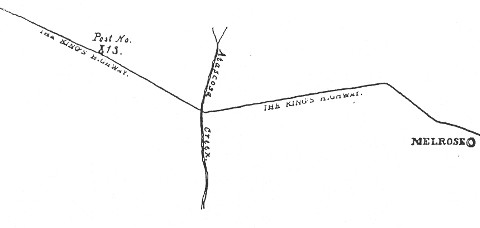
- Map of the Old San Antonio Road in East Nacogdoches County
- Marker #10
- Marker #11
- Marker #12
- Marker #13
Zively placed nine oak survey posts in Nacogdoches County. This page covers the four on the eastern half of the route through the county: one at the Attoyac River (the San Augustine County line), and three on the way to Nacogdoches. Three of the markers have been found and are publicly accessible. The marker by the river has been moved a short distance. The marker west of Chireno is at its survey post location. The other found marker, near Melrose, has been moved at least two miles.
Map of the Old San Antonio Road in East Nacogdoches County
[-]Collapse Map [+]Expand Map
|
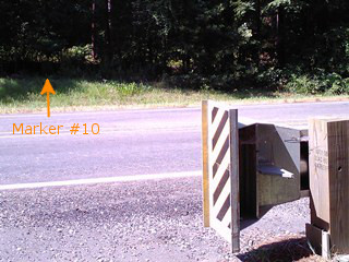
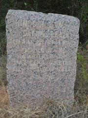
Marker #: 10
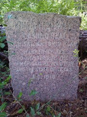
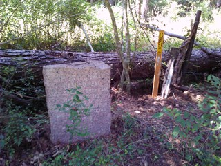
Coordinates: 31.5046023, -94.307046 Location: SH 21 on the west bank of the Attoyac River Relation to road: 70 ft from north stripe, facing road, S 180° Distance from post: 0.1 mi, on route Dimensions: 45" x 25" x 12" Setting: Dirt Other Markers/Signage: No Visibility: Very low Accessibility: Below average This marker is at the west end of the bridge over the Attoyac River, which is the Nacogdoches-San Augustine County line. It is directly across from the end of the bridge's south culvert. It is at the fence line and among some partially-cleared brush and trees. It is difficult to spot, even from a short distance away. There are some gas utility markers next to it, which are a little easier to spot than the granite marker. The site is completely unimproved. There is no pull-off. The shoulder might not be a good idea for all vehicles. You can pull over either on the dirt "road" just west of the marker or on the paved local road a little further down on the south side of the highway. The marker stands 45 inches above ground, which makes it taller than average. The fact that so much of it sticks out of the ground could mean that it has been moved recently. Its top slopes from left to right. Zively's survey shows that the road in 1915 curved to the south to cross the river. That curve has since been straightened. If the marker had never been moved, it would probably be on the south side of the bridge today. Besides being moved to the north side of the road, the marker has been moved west, away from the river, undoubtedly because the current bridge is much longer than the bridge that was there in 1915. Observed on August 10, 2013. |
|
|
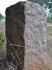
Marker #: 11
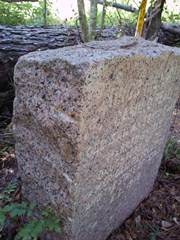
Coordinates: 31.52312, -94.36872 Location: SH 21 west of Chireno. Relation to road: 35 ft from north stripe, facing road, SW 240° Distance from post: At post Dimensions: 28" x 23" x 14" Setting: Grass/dirt Other Markers/Signage: No Visibility: Medium to low Accessibility: Good in dry weather This marker is 1.4 miles west of Farm-to-Market Road 95 in Chireno, and 0.5 mi east of County Road 355. It is exactly where Zively's survey shows it to be. The marker is set in dirt and grass at the brush line, across from the drainage ditch. The surrounding brush makes it a little difficult to spot. There is a hard, but narrow shoulder between the road and the ditch. One should have no trouble getting to the marker as long as the ditch is dry. Despite Marker #11 being exactly where it is expected, the Texas Society DAR lists it as not found on its 2001 project web site, and its coordinates on the El Camino Real de los Tejas National Historic Trail Association's interactive web map in 2013 were off by 0.3 miles. Our visit in August 2013 was the first time it was documented at this location. Observed on August 31, 2013. |
|
|
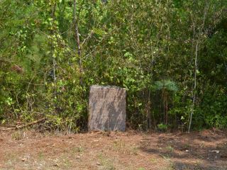
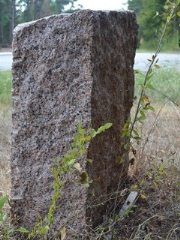
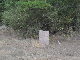
Marker #: 12
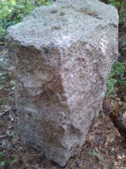
Coordinates: 31.565295, -94.48926 Location: SH 21 near Melrose. Relation to road: 35 ft from north stripe, facing road, S 170° Distance from post: 2.0 mi west, on route Dimensions: 37" x 25" x 13" Setting: Grass/dirt Other Markers/Signage: No Visibility: Medium Accessibility: Fair in dry weather Zively's sketch shows Post #12 east of Melrose. There are no notes on the sketch to provide additional information. Based on the sketch, and on Zively's measurement that this post was 26,640 feet (5.05 miles) from Marker #11, which is precisely where Zively surveyed it, Marker #12 ought to be 1.3 miles west of County Road 338. Instead, it is a full 2 miles further west, at the intersection of Highway 21 and County Road 302, which was the road to Nacogdoches before Highway 21 was built. It does mark Zively's Old San Antonio Road route at its current location. The marker is set in grass in a clearing for the intersection. The clearing is marred by numerous deep wheel ruts where vehicles have cut the corner in the mud. There is room to park safely on CR 302 just past the turn. It is unknown when this marker was moved, by whom, or why. The Texas Society DAR did not find it during their 1995-2001 OSR marker rededication project. It can be seen on a Google Street View photo from March 2008, but it was not on the El Camino Real de los Tejas National Historic Trail's interactive map in 2013. It is possible that this is actually the marker for survey post #13, whose marker is still missing. Observed on August 31, 2013. |
|
|
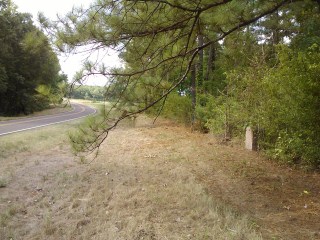
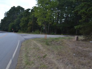
Marker #: 13
Coordinates: N/A Location: Not found Zively's sketch shows this missing marker's survey post location as west of Atascosa Creek, between Melrose and Nacogdoches. Zively noted that the marker was "in L. Dean's Field ...(illegible)... small skirt of timber." The marker's expected location is at a small dirt road east of CR 313 called Scott Lane. This happens to be the same location where State Highway 21 diverges from Zively's surveyed route. Specifically, Highway 21 turns to the west, while Zively's route continued straight northwest. If the marker is still in the area, it could be on some private property north of Highway 21. It is not on Scott Lane. There is a granite OSR marker 2.8 miles to the east on Highway 21. We have catalogued that marker as #12 on this web site. It is possible, however, that marker is actually #13, and Marker #12 is the one that is still missing. Observed on August 10, 2013. |
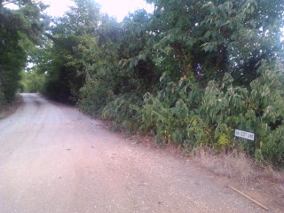
Above: Scott Lane at Highway 21.
|
- Zively, V.N. - "Field Notes and Detail Map of the Kings Highway", 1916
- Carson, David - field notes observed and recorded in 2013.
- Texas Society of the DAR - Old San Antonio Road DAR Marker Information Site
- El Camino Real de los Tejas National Historic Trail Association