
The Old San Antonio Road Posts and Markers on the Brazos-Robertson County Line
The Old San Antonio Road Posts and Markers on the Brazos-Robertson County Line
- Map of the Old San Antonio Road on the Brazos-Robertson County Line
- Marker #41
- Marker #42
- Marker #43
- Marker #44
- Marker #45
Zively placed seven oak survey posts in Brazos County and on its boundary with Robertson County. Five of them were on the Brazos-Robertson county line, as shown on this map. All five of their matching granite markers still exist at or near their original locations.
Map of the Old San Antonio Road on the Brazos-Robertson County Line
[-]Collapse Map [+]Expand Map
|
Marker #: 41
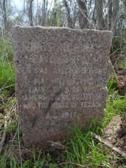
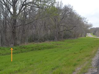
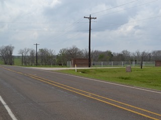
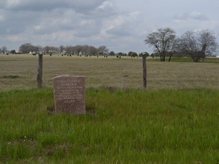
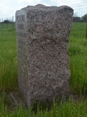
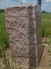
Coordinates: 30.971051, -96.248107 Location: Highway OSR, west of the Navasota River Relation to Road: 60 ft from south stripe, facing road, NW 330° Distance from post: At or near post Dimensions: 32" x 25" x 18" Setting: Mud and weeds Other Markers/Signage: No Visibility: Low Accessibility: Poor This marker is approximately 0.4 miles west of the Navasota River on State Highway OSR. It is on the south side of the highway, in front of the tree line. It is hidden from the north by a hill and separated from the highway by 60 feet of low-lying, marshy, rut-carved, mud, grass, and weeds. It is difficult to find, and even more difficult to get to once you have found it, especially after a rain. The marker is in excellent condition. It is rectangular from the front view. From the side, it has an unusual shape, being of average depth at the bottom, thicker in the middle, and thin at the top. From a certain angle, it resembles the outline of a woman's torso. Zively depicted this marker as being placed on the west bank of the river, as if it were only 100 feet or so from the water. He even noted that the marker was "On the West Bank of the Navasoto [sic] River, at the common corner of four Counties, Madison & Leon, Robertson & Brazos." In actuality, the marker is 0.4 miles from the river and the common corner. These county boundaries were established in 1853, long before Zively's visit, and have not changed. Likewise, the river is in the same place today as when Zively was there. An easy explanation for this discrepancy would be if the marker has been moved, but that does not appear to be the case: it is the correct distance from Markers #40 and #42, as well as from other identifiable points on the survey. It is, in fact, the Navasota River that is in the wrong place on Zively's survey; it is drawn over a quarter of a mile too far west. One can only speculate as to why Zively placed his survey post so far from the river, but apparently even he forgot that he had done so when he prepared his sketches. He must have assumed that he had followed his custom of placing markers on rivers and county lines. Highway OSR is now somewhat further north of Zively's survey in this location, which may be why the marker is now on the south side of the highway. The marker has been reoriented to face the highway. It may also have been moved closer to the highway - no more than three hundred feet, if that - in the process. Observed on March 22, 2014. |
|
|
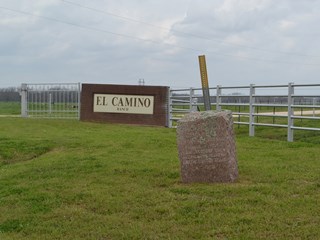
Marker #: 42
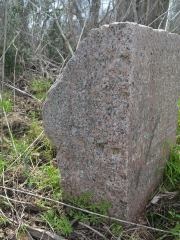
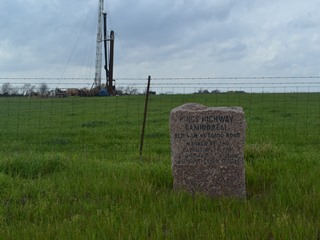
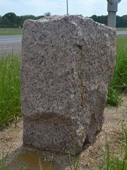
Coordinates: 30.934035, -96.315954 Location: Highway OSR at Little Cedar Creek, 5 miles west of the Navasota River. Relation to Road: 34 feet from north stripe, facing road, SE 140° Distance from post: At post Dimensions: 32" x 25" x 18" Setting: Concrete covered by grass and dirt Other Markers/Signage: No Visibility: Medium Accessibility: Good This marker is 3.6 miles west of Farm-to-Market Road 1940 and 1.0 mile east of Edge Cut Off Road. It is between Snake Branch Creek and Little Cedar Creek at the entrance of the El Camino Ranch. There is no sign for the marker itself, but the ranch entrance is very easy to spot. The marker is set in a lawn of mowed grass outside the gate. There is a metal signpost behind the marker, but there is no sign on it. There is no pulloff, but the grass shoulder is wide and solid. If there is water in the ditch, you can walk to the marker via the driveway. From the surface, the marker appears to be set in dirt and grass, but in fact there is a concrete base a few inches underground. The upper two-thirds of the marker's face are noticeably more weathered than the lower third. It is possible that at one point, the marker was dug up and raised a few inches, and the concrete was added at that time to keep it from sinking again. The marker leans noticeably to the left. It appears to be more level in a photo made between 1995 and 2000 by a researcher for the Texas Society Daughters of the American Revolution (link to photo). Also, the signpost behind the marker is not present in that photo, nor are the lichens that are seen today on the marker's face. Zively placed his survey post for the marker on the east bank of Little Cedar Creek, and State Highway OSR matches his survey of the Old San Antonio Road in this area. If the marker has been moved from its original position, it hasn't moved far. Observed on April 19, 2014. |
|
|
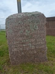
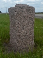
Marker #: 43
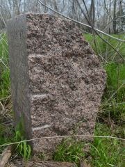
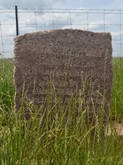
Coordinates: 30.880590, -96.370144 Location: Highway OSR near Wheelock Relation to Road: 30 feet from north stripe, facing road, SE 130° Distance from post: At post Dimensions: 37" x 28" x 12" Setting: Concrete surrounded by grass Other Markers/Signage: No Visibility: Medium Accessibility: Average This marker is on State Highway OSR approximately halfway between the Navasota River and SH 6. It is about 500 feet west of the highway's intersection with FM 46. There is a gas station/convenience store directly across the road from it. There is an asphalt pulloff in front of the marker, which is in front of a fence for a cow pasture. It is set in a concrete base and surrounded by grass. The marker tilts slightly to the left and is wider at the top than at the bottom. It is spotted with lichens. There are some brown-colored abrasions along the bottom front, which are hidden by the grass in our photos. The lower third of the marker is noticeably less weathered than the upper two thirds. This is a clue that the marker may have rested deeper in the ground for a long time, perhaps because it sank. If so, it was probably dug up and set in concrete to make it more visible and stop it from sinking further. Its nearest neighbors, Markers #42 and #44, appear to have gotten a similar treatment. This marker is at its original location. Observed on March 22, 2014. |
|
|
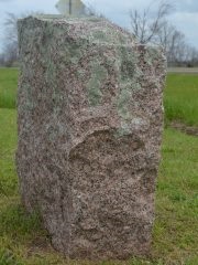
Marker #: 44
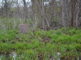
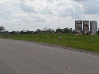
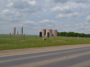
Coordinates: 30.820374, -96.412801 Location: Highway OSR, between Highway 6 and Wheelock Relation to Road: 31 feet from north stripe, facing road, SE 130° Distance from post: At post Dimensions: 35" x 27" x 16" Setting: Concrete Other Markers/Signage: No Visibility: Medium Accessibility: Good This marker is in front of an oil drilling field on Highway OSR nearly 6 miles northeast of Highway 6. It is a short distance northeast of Castenson Road, 1.6 miles southwest of Dick Elliott Road and 1.6 miles northeast of FM 2223. There are three large, old, metal storage tanks in the field behind the marker and other oilfield structures and machinery in the immediate area. The marker is set in a square patch of concrete in the grassy right-of-way between the fence and the highway. There is an asphalt pulloff in front of it. The upper half of the marker is more weathered than the lower half, suggesting that it used to rest deeper in the ground. The lettering on the face of the marker was once painted in with dark gray paint. Much of this paint has since worn off. This marker is at its original location. Observed on April 19, 2014. |
|
|
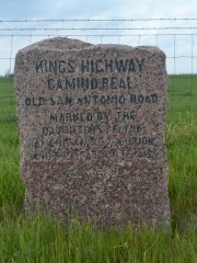
Marker #: 45
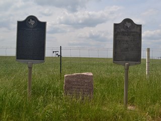
Coordinates: 30.755733, -96.451097 Location: Highway OSR, northeast of Highway 6 Relation to Road: 29 feet from north stripe, facing road, E 110° Distance from post: At post Dimensions: 35" x 27" x 16" Setting: Concrete Other Markers/Signage: Yes Visibility: Medium Accessibility: Good This marker is in front of an oil field on Highway OSR 0.7 miles northeast of Highway 6. It is set in concrete between two state historical markers. Normally, state historical marker signs are indicated with highway signs, but there is no signage for this site. The site is not hard to spot, however, and there is an asphalt pulloff for parking. One must take a short walk through some tall grass to get to the marker, but it is in a high, well-drained area, so it should be easy to walk to even after a heavy rain. This marker is at its original location. It has no unusual or notable physical characteristics. The state historical marker on the left is for Staggers Point, an Irish community that existed nearby from 1833 to 1868. The marker on the right gives a brief history of El Camino Real and the Old San Antonio Road. The markers are dated 1973 and 1968, respectively. Observed on April 19, 2014. |
|
- Carson, David - field notes observed and recorded in 2014
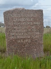
- Zively, V.N. - "Field Notes and Detail Map of the Kings Highway", 1916