
The Old San Antonio Road Posts and Markers in Lee County
The Old San Antonio Road Posts and Markers in Lee County
- Map of the Old San Antonio Road in Lee County
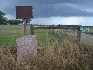
- The Lee County Signs
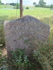
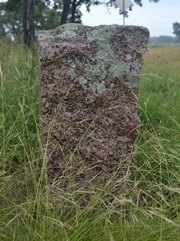
- Marker #55
- Marker #56
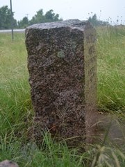
- Marker #57
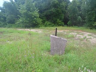
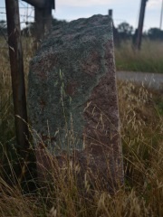
- Marker #57B
- Marker #58
- Marker #59
Zively placed five oak survey posts in Lee County, three northeast of the town of Lincoln, and two southwest of Lincoln. The matching granite markers for all five have been found. Three of them have been moved. Two of the moved markers are still on Zively's route, while the other one is slightly off of it. There is also a mysterious sixth marker in Lincoln that must have been moved in from another county.
Map of the Old San Antonio Road in Lee County
[-]Collapse Map [+]Expand Map
|
The Lee County Signs
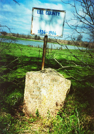
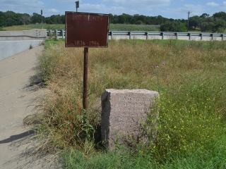
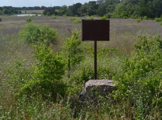
Four of the DAR granite Old San Antonio Road markers in Lee County have the same sign placed behind them. This sign was constructed of metal and plywood and affixed to a metal post. Today, the plywood is rotten, the sheet metal and post are badly rusted, and the markings on the signs are barely legible, but they can be made out to read "LEE COUNTY" along the top and "1836-1986" along the bottom. The signs are easier to make out in the photographs made by the Texas Society DAR between 1995 and 2001. In their photos, the frames and posts had already rusted, but the markings painted onto the sheet metal were still in fairly good condition. As the DAR's photos show, the large area between "LEE COUNTY" and "1836-1986" seems to have always been blank. The year 1836 does not hold any particular significance to Lee County, which was created in 1874, or to the Old San Antonio Road or the markers. The signs were presumably erected in 1986 in observance of Texas' sesquicentennial. During this author's field trips to Lee County in 2014, these signs were observed behind Markers #55, 56, 57, and 58. The latter three were mounted directly behind and up close to - almost in contact with - the granite marker. The sign for Marker #55 was slightly off to the left side. Marker #57B had a pole, but the top of the sign had been sawn off. Marker #59 did not have a sign. The author did not spot any of these signs at other historic locations in Lee County; it seems that they were made specifically for the OSR markers. |
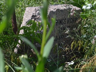
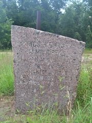
 Above: The Texas Society DAR's photograph of Marker #57 made between 1995 and 2001, showing the sign when it was newer. |
|
Marker #: 55
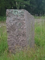
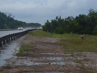
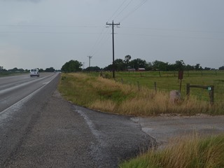
Coordinates: 30.405617, -96.818384 Location: SH 21 at East Yegua Creek (Burleson-Lee County line) Relation to Road: 24 feet from south stripe of westbound lanes, facing road, 320° Distance from post: Near post Dimensions: 35" x 31" x 14" Setting: Dirt and grass Other Markers/Signage: Yes Visibility: Medium Accessibility: Medium This marker was originally placed at the west corner of the Old San Antonio Road and East Yegua Creek - that is, northwest of the road and southwest of the creek. State Highway 21 now follows the same route as the OSR, but the modern highway is now four lanes with a median, so it is much wider. The marker has been relocated, probably as a result of construction and possibly more than once, but it is essentially in the same location as it was originally placed. It is now in the median of the divided highway, closer to the westbound lanes and facing them. The bridge has shoulders, so it is possible to park very close to the marker, but you will have to step over or walk around the guard rail. The marker is tilted to the right. A ground probe indicates that it is resting on rubble, not set in a solid concrete foundation. A "Lee County 1836-1986" sign is behind and to the left of the marker. The placement of the sign is different from the other Lee County OSR markers, where the signs are centered directly behind the granite markers. The difference in the sign placement is probably a result of this marker and sign being moved recently. The Texas Society DAR's record of Marker #55, made between 1995 and 2001, differs substantially from our observations, made in 2014. The DAR wrote, "The Marker is down a steep embankment on the Southwest side of the road." The researcher apparently meant to write "southeast", for the highway has no southwest side, and open, grassy areas such as the one in their photograph do exist down the embankment on the southeast side of Highway 21. There is no Lee County 1836-1986 sign in their photo of Marker #55. Most important of all, the granite marker shown in their photograph, although definitely a DAR granite OSR marker, does not seem to be the same marker that is now in place at the site - theirs has beveled top corners and a bread slice-shaped face, while ours has clean, square top corners and a rectangular face. This raises many questions. There are numerous other problems with photos and descriptions on the DAR's page for Lee County, including a photo mixup with Markers #59 and #60, so it is possible that their photo of Marker #55 is part of another mixup. The only certainty, established by Google Street View archives, is that the granite marker and sign in our photographs were moved to their current location between February 2008 and May 2011. Observed on May 31, 2014. |
  Below: The Texas Society DAR's photograph of Marker #55 from 1995-2001. 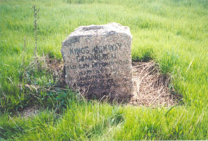 Below: This field down the bridge embankment on the southeast side of Highway 21 could be where the above photo was made.  |
|
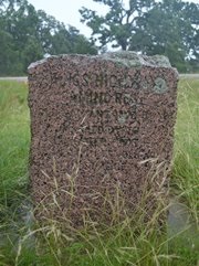
Marker #: 56
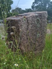
Coordinates: 30.368932, -96.873518 Location: SH 21 southwest of Old Dime Box Relation to Road: 24 feet from north stripe, facing road, SE 130° Distance from post: At post Dimensions: 27" x 31" x 15" Setting: Concrete sunk into the ground Other Markers/Signage: Yes Visibility: Low Accessibility: Medium This marker is on Highway 21 west of Old Dime Box, slightly east of the intersection with County Road 430 and across from Iselt's Concrete plant. It is in tall weeds in front of a pasture fence. It would be invisible if not for the sign behind it, which is itself barely visible. There is not an improved shoulder for parking. Visitors can pull off onto the grass or park on the side of CR 430. The marker is set in a concrete base, but the base and marker have sunk into the ground. The concrete base, now under about an inch of dirt, is level with the ground in the Texas Society DAR's photograph. A triangle has been engraved into the face of the marker, above the original engraving. Both the lettering and the added triangle have been darkened to make them more visible. Unlike other OSR markers, however, where the lettering was filled in with dark gray paint that has chipped away over the years, the darkening of Marker #56 was accomplished by discoloring the granite itself, and appears to be more permanent. This marker appears to be at its original location. Observed on May 31, 2014. |
 |
|
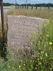
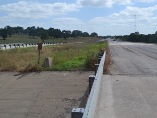
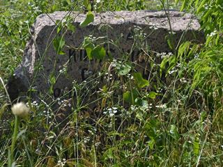
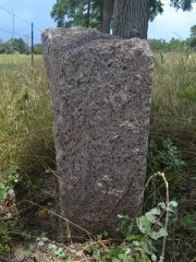
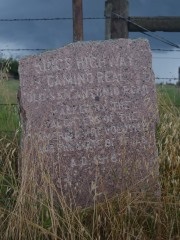
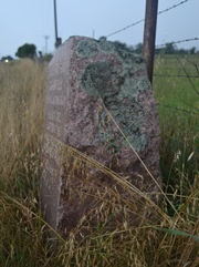
Marker #: 57
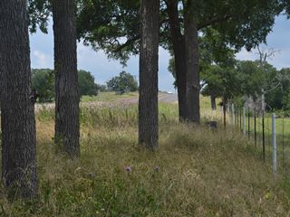
Coordinates: 30.322003, -96.926998 Location: SH 21 northeast of Lincoln Relation to Road: 35 feet from north edge, facing road, SE 130° Distance from post: 0.2 miles from post, off route Dimensions: 36" x 28" x 13" Setting: Concrete Other Markers/Signage: Yes Visibility: Medium Accessibility: Medium About 1½ to 2 miles northeast of Lincoln on Highway 21, County Road 440 preserves a section of the Old San Antonio Road that Highway 21 has bypassed. Zively placed his survey post for Marker #57 on what is now CR 440, about 0.2 miles west of that road's eastern intersection with Highway 21. The marker is now on Highway 21, 0.1 miles west of the same intersection. Therefore, it is about 0.2 miles southeast of its original position and is no longer on Zively's route. The marker can now be found under some large trees in front of the fence of a scenic pasture with a nice pond. It is difficult to spot from an angle because of the trees and the tall grass. The "Lee County 1836-1986" sign behind the marker is in better condition than the signs at the other markers. The marker is embedded in concrete, but the marker and its concrete setting have begun to sink into the ground. The owner of the home near the marker's original location said in 2014 that he remembered when the marker was at the corner of his driveway. He said it was mostly covered in shrubs and did not have a sign with it. He could not remember what year it was moved, but since the signs were probably placed in 1986, it was probably moved at that time or earlier. It was at its current location on Highway 21 when the Texas Society DAR documented it between 1995 and 2001. Observed on May 31, 2014. |
   |
|
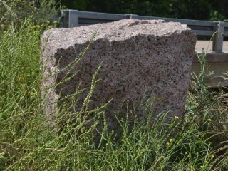
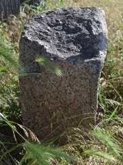
Marker #: 57B
Coordinates: 30.291272, -96.960875 Location: SH 21 at West Yegua Creek Relation to Road: 35 feet from southeast stripe, facing road, W 270° Distance from post: No post, 0.5 mi off route Dimensions: 36" x 30" x 15" Setting: Concrete Other Markers/Signage: No Visibility: Depends on approach Accessibility: Excellent This marker is on the south or west bank of West Yegua Creek. It is behind the Highway 21 bridge guard rail on the southeast side of the highway. The marker is in an open area that used to be a picnic area. The picnic area was removed sometime between February 2008 and May 2011, and the bridge guard rail was extended past the entrance. The OSR marker is still accessible via the highway shoulder, and there is plenty of room off the highway to park. The marker is highly visible when approaching from the southwest, but difficult to spot when approaching from the northeast. Visitors approaching it from the northeast will need to drive past it and turn around. The top of the marker slopes sharply from left to right. There is a black substance on the top of the marker and there are lichens on the sides. Behind the marker is a post for a sign like the "Lee County 1836-1986" signs at other markers, but the sign itself has been sawn off. V.N. Zively, who surveyed the Old San Antonio Road and placed the survey posts that were subsequently marked with these pink granite markers, did not indicate placing a survey post here on his sketch or notes. One can only guess as to how this marker got here. It is unlikely that it represents a survey post that Zively failed to note in his sketches, because it is too close to #57 and #58. Zively's survey posts were generally around five miles apart, and the distance between survey posts #57 and #57B is #58 2.9 miles, while the distance between #57B and #58 is 2.3 miles. Together, the distance between #57 and #58 is 5.2 miles, which is within the usual range. Perhaps this is simply an extra marker that the granite contractor left here, or perhaps it was moved here from somewhere else. If it was moved here, it had to have been moved at least 34 miles, for the closest missing marker is #49 in Burleson County.1 The Texas Society DAR found it at this location between 1995 and 2001. As their photo and the researcher's notes indicate, the concrete base looked new at that time. Nothing is known about this marker prior to the DAR's visit. Observed on May 31, 2014. |
   |
|
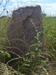
Marker #: 58
Coordinates: 30.262832, -96.974243 Location: SH 21 southwest of Lincoln Relation to Road: 28 feet from north stripe, facing road, S 160° Distance from post: At post Dimensions: 35" x 25" x 16" Setting: Grass Other Markers/Signage: Yes Visibility: Medium Accessibility: Fair This marker is at the corner of Highway 21 and the driveway for the property at the address 2278 Highway 21. It is 0.8 miles southwest of the intersection of Highway 21 and FM 1624. It is in front of a farm house and across the highway from two more houses. It is in a patch of weeds in front of a fence. A deteriorated "Lee County 1836-1986" sign is behind it. Parking is tricky due to the narrow highway shoulder, the narrow driveway, and a culvert that is easy to drive off of. The top, rear, and sides of the marker are coated with lichens. The face is clean. The Texas Society DAR reported that this marker was lying face down on the ground when they visited the site between 1995 and 2001. It was reset sometime since then and sometime before February 2008. It is set in ordinary topsoil and will probably sink over the next few decades. Observed on May 31, 2014. |
   |
|
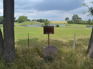
Marker #: 59
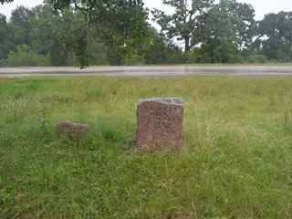
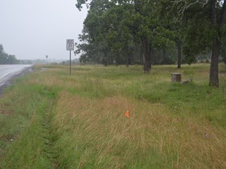
Coordinates: 30.231695, -97.025965 Location: SH 21 east of Lee-Bastrop County line Relation to Road: 38 feet from north stripe, facing away from road, N 10° Distance from post: 1.0 mile east of post, on route Dimensions: 36" x 28" x 13" Setting: Concrete Other Markers/Signage: Yes Visibility: Medium Accessibility: Medium This marker is on Highway 21 less than 0.1 miles west of the intersection with FM 2440. It is on the north side of the highway. The marker's location used to be a small rest area with a picnic table, litter barrels, and a paved driveway. The marker faces away from the highway and toward where the driveway once was. Since 1999, however, the state of Texas has been removing small, casual rest areas such as this one in favor of large rest areas on interstate highways that include restrooms, vending machines, security cameras, and nighttime illumination. This rest area was still open in February 2008, but by May 2011, it was closed, and the paved driveway was taken out, leaving a bed of dirt and gravel. In 2013, there was still a cleared dirt path where one could easily park to visit the marker, but as of May 2014, the path was becoming overgrown and difficult to use, especially in wet weather. Parking is still possible on the highway grass shoulder. The marker is set in concrete among weeds. There are tree droppings and lichens on many of the surfaces. This is the only OSR marker in Lee County that does not have a "Lee County 1836-1986" sign or signpost with it. Next to the OSR marker, a smaller granite marker, dated 1936, indicates that the site was donated to the state of Texas by an individual for park purposes. It is not seen next to the OSR Marker in a February 2008 photo, but it may have been at another location at the site at that time. Observed on May 31, 2014. |
   |
1The town of Cooks Point in Burleson County, which is about 3 miles from missing Marker #49's original location, features a church and four houses made of petrified wood. The area around Lobeau, which is about two miles from Marker #57B, is known for petrified wood. According to a Lincoln-area resident this author interviewed in 2014, the stone used to build houses at Cooks Point was excavated from Lobeau. While the fact that trucks hauled stone from West Yegua Creek to Cooks Point does not prove that they hauled this marker back, it does indicate that an opportunity and a possible motive for moving Marker #49 to this area did once exist. Only two things are certain: 1) Marker #57B came from somewhere, 2) and of the DAR markers that are missing, Marker #49 would have had the shortest distance to travel to this location.
- Carson, David - field notes observed and recorded in 2014
- Zively, V.N. - "Field Notes and Detail Map of the Kings Highway", 1916
- Texas Society Daughters of the American Revolution - Old San Antonio Road DAR Marker Information Site