
The Old San Antonio Road Posts and Markers in East Bastrop County
The Old San Antonio Road Posts and Markers in East Bastrop County
- Map of the Old San Antonio Road in East Bastrop County
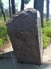
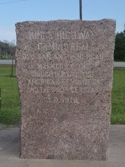
- Marker #60
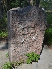
- Marker #61
- Marker #62
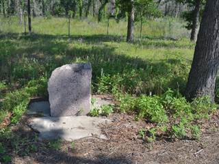
- Marker #63
- Marker #64
- Marker #65
Zively placed nine oak survey posts in Bastrop County. Six were in the eastern part of the county depicted on this map. All six have been found. Two of those are in their original locations. The other four have been moved varying distances, and only one of them is still on Zively's route.
Map of the Old San Antonio Road in East Bastrop County
[-]Collapse Map [+]Expand Map
|
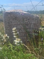
Marker #: 60
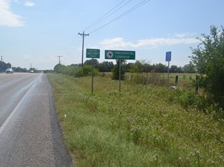
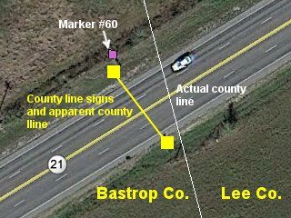
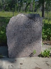
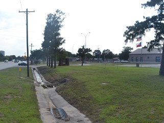
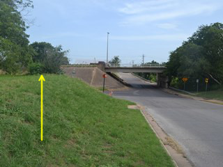
Coordinates: 30.229620, -97.073668 Location: SH 21 at the Bastrop-Lee County line east of Paige Relation to Road: 30 feet from north stripe, facing road, SE 130° Distance from post: at post Dimensions: 30" x 29" x 19" Setting: Dirt and weeds over a concrete base Other Markers/Signage: Yes Visibility: Good Accessibility: Fair This marker is on the north side of Highway 21 at the Bastrop-Lee County line, which is 4.4 miles east of US Highway 290 and 3.1 miles west of Farm-to-Market Road 2440. The county line is well-marked on both sides of the highway from both directions, and there are other signs at the site as well, making the site almost impossible to miss. The marker itself is a little difficult to see in the tall weeds. It is in front of the fence line for a pasture a few feet east of the county line signs. There is no pulloff, and using the narrow shoulder can be tricky because the site is on top of a hill and offers limited visibility in what can be a high-traffic area. Once you find a place to park, you have to walk across a ditch to get to the marker. Accessibility, therefore, is fair. The marker is set in concrete that has sunk several inches into the ground. This marker is at its original location. A visit to the site gives the impression that it is on the Lee County side of the line, which would mean it has been moved, but the posted signs depict the county line inaccurately. While a county line marker posted on the fence line on the south side is accurate, from there, the signs posted on the south shoulder and the north side of the highway treat the county line as if it crossed the highway perpendicularly, when it actually crosses the highway at an angle. Consequently, the signs on the north side of the highway are about 10 to 15 feet too far west. The aerial photo at bottom right shows the relationship between the true county line, the line depicted by the current highway signs, and Marker #60. Observed on May 31, 2014. |
    |
|
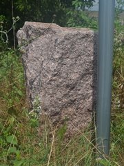
Marker #: 61
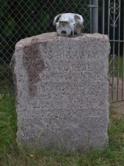
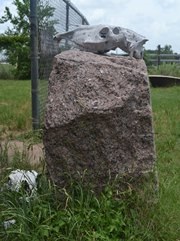
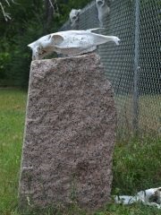
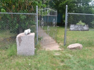
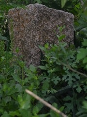
Coordinates: 30.214017, -97.117281 Location: Rural Paige Relation to Road: 0.2 miles from Gonzales St, E 90° Distance from post: 0.4 miles west of post, off route Dimensions: 33" x 29" x 20" Setting: Dirt/grass Other Markers/Signage: No Visibility: None Accessibility: Excellent This marker is at the end of a dirt road in Paige. The unmarked road, which runs parallel to the railroad track on the north side, is called Rail Road Lane on some maps and Reservation Street on others. The marker is 0.2 miles west of Gonzales Street/County Road 175. It cannot be seen from any highway, or even from Gonzales Street. Once you drive sufficiently far down the dirt road, the marker is easy to spot. It is in front of the front gate of a fence surrounding an old house. The fence and the area in front of it, including the marker, have been decorated with cow skulls. The marker is set in dirt. There are many scratches all over its face. There is a very noticeable discolored area on the face and top, which appears to have been made by a liquid dripping on it. There is a large chunk of pink granite on the ground on the other side of the gate. There is no doubt that it is the same kind of rock that the DAR granite markers are made from, so it is most likely a chunk off of this marker. It must be from a part of the marker that is below ground, for the part that is above ground is fully intact. The marker is about 0.4 miles east of its original location, which was at the intersection of the Old San Antonio Road and the Houston & Texas Central Railroad track west of Paige. Highway 21 now crosses the railroad track via an underpass that is some 250 feet to the west of Zively's surveyed route. The current highway routes and underpass are depicted on a 1961 map of Bastrop County, so they were completed some time before then. The elderly woman living at the house where the marker is found said in 2014 that it was there, in its present setting, when she moved in. She could not remember when that was, except that it was "a long time" ago. It might have been there since whenever Highway 21 was rerouted, presumably in the 1940s or 1950s. This marker was not found by the Texas Society DAR during their 1995-2001 OSR marker rededication project. The coordinates given for it on the El Camino Real National Historic Trail Association's interactive map in 2013 were correct. Observed on June 21, 2014. |
   |
|
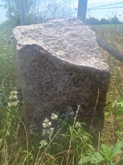
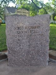
Marker #: 62
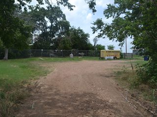
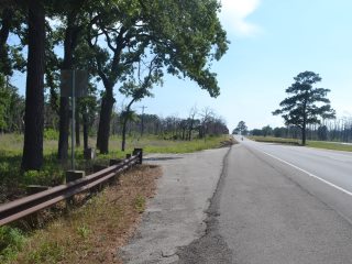
Coordinates: 30.157091, -97.216053 Location: SH 21 between US 290 and Bastrop State Park Relation to Road: 36 feet from south stripe, facing road, NW 320° Distance from post: 1.8 miles southwest of post, off route Dimensions: 34" x 31" x 22" Setting: Concrete Other Markers/Signage: No Visibility: Low Accessibility: Excellent This marker is in a heavily wooded residential area on the northeastern outskirts of the city of Bastrop. It can be found between "County Road", or Bastrop County Road 130, and Cardinal Dr/CR 133 under some trees on the south side of the highway. It is 0.7 miles east of FM 1441 and about 6 miles west of US Highway 290. It is difficult to spot when driving northeast from Bastrop and impossible to spot when driving southwest from US 290. Once you know where it is, there is a crossover in the median of the divided highway that makes the marker easy to access from either direction. There is a small pulloff for parking. The marker is set in concrete underneath some large hardwood and pine trees. This area used to be a small rest area with a picnic table, litter barrels, and a paved parking lot with ample space to park multiple vehicles, including RVs. Some time between April 2008 and May 2011, the amenities were removed, leaving only the granite marker.1 A rail was subsequently extended, reducing parking availability, but enough room was left for visitors to stop at the marker. Marker #62 has been moved and is no longer on Zively's route. It was originally placed about 1.8 miles northeast on Highway 21, a little less than a mile from Alum Creek. Highway 21 still follows Zively's route at the original location of Marker #62, and it is in a relatively undeveloped area, so there is no apparent reason why it could not be moved back there. Coordinates for Marker #62's current location were added to Wikipedia on 28 July 2005. It is not known how long prior to that it had been there. The Texas Society DAR did not find it during its 1995-2001 OSR marker rededication project. Since it is quite far from its original location and is easy to miss, the DAR researcher may have simply overlooked it. Observed on May 31, 2014. |
 |
|
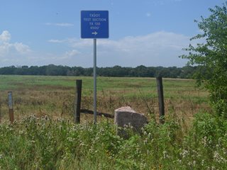
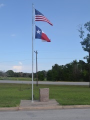
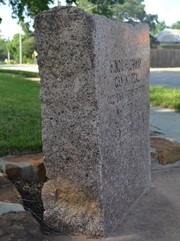
Marker #: 63
Coordinates: 30.112564, -97.290489 Location: SH 21 on the east side of Bastrop Relation to Road: 108 feet from north stripe, facing away from road, NW 300° Distance from post: 3.0 miles southwest of post, off route Dimensions: 40" x 31" x 16" Setting: Concrete Other Markers/Signage: No Visibility: High Accessibility: Excellent This marker is in front of the Texas Department of Transportation building at 174 SH 21 E in Bastrop. It is about 0.2 miles east of the entrance to Bastrop State Park, or about 0.9 miles east of State Highway 95. The marker is set in concrete next to a flagpole adjacent to the parking lot, close to the front entrance to the building. This marker is an excellent specimen. It has an even, rectangular shape with flat sides, parallel lines, and square corners. It is also clean. This marker is about 2.9 miles southwest of its original location. It is no longer on Zively's route. Marker #63's original location is not on Highway 21 and is on land now occupied by the Pine Hills subdivision. The Texas Society DAR documented Marker #63 in front of the TXDOT building in 1995 and 2001, but it was on the grass shoulder of Highway 21, not on TXDOT's property. From the DAR's photo, the marker appeared to have been set there recently. It has been at its current location by the flagpole since at least February 2008. Observed on May 31, 2014. |
 |
|
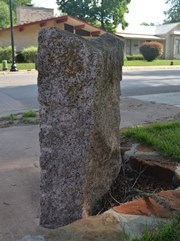
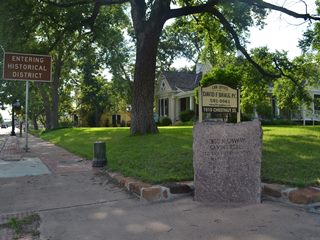
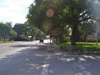
Marker #: 64
Coordinates: 30.110671, -97.315175 Location: Downtown Bastrop, Historic District Relation to Road: 10 feet from west curb of Hill St., facing into intersection, SE 120° Distance from post: At post Dimensions: 40" x 33" x 12" Setting: Concrete Other Markers/Signage: No Visibility: High Accessibility: Excellent This marker is at the corner of Chestnut and Hill Streets in downtown Bastrop. Chestnut Street is also called Loop 150. This intersection is at the edge of Bastrop's historic district. Street parking is available on Hill Street. The marker is set in concrete on the corner of the sidewalk on the northwest corner of the intersection. It is oriented to face southeast into the center of the intersection. It is under a shade tree in front of a grass lawn for a business on the corner and is separated from the lawn by a stone border. There are no other signs or markers accompanying the granite marker, but there is a sign reading "Entering Historical District" nearby. Additionally, there are bronze medallion decorations in the sidewalk along Chestnut Street in both directions. These medallions read "El Camino Real de Los Tejas Old San Antonio Road" and commemorate various events in the history of Bastrop, El Camino Real, and Texas. With a depth of only 12 inches, this marker is unusually small. It is lightly covered with tree residue. This marker is at its original location, plus or minus a few feet. When the Texas Society DAR visited the site between 1995 and 2001, it was on the grass directly behind the stop sign on Hill Street, facing southeast. The sidewalk medallions on Chestnut Street were unveiled on 17 July 2010 as part of a renovation project; the OSR marker was apparently relocated around the same time. Observed on May 31, 2014. |
   |
|
Marker #: 65
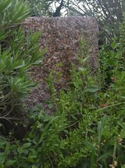
Coordinates: 30.105287, -97.318553 Location: Downtown Bastrop on the Colorado River Relation to Road: 27 feet from east curb of Water St., facing intersection, SW 210° Distance from post: 0.1 mile north of post, on route Dimensions: 31" x 28" x 13" Setting: Dirt and landscaping Other Markers/Signage: No Visibility: Very low Accessibility: Fair This marker is on a residential lot at the corner of College Street and Water Street just north of Highway 21/71 in downtown Bastrop.2 Visitors can park on the street or at a small park across Water Street, where there is an El Camino Real informational poster. The marker is set in a landscaped area among oleander shrubs, agave plants, flowers, and ground cover. The area is surrounded by white stone blocks. It is about eight to ten feet above street level and is only accessible by either climbing up a steep grassy incline or by walking along either street and coming up via a longer but gentler incline. The plants have overgrown the marker and have all but hidden it from the face and sides. The overgrowth and the placement of the marker at an elevation above eye level make it extremely difficult to spot from the street. The landscaped area is easy to spot, but one would have no idea there is a granite OSR marker underneath the plants without first climbing the hill to take a look. One also gets the feeling of invading the privacy of the residents whose lot the marker is on, especially when walking behind the marker so as to view the only side that is not yet completely enveloped by plants. According to Zively's survey, this marker was originally placed further south along the river, probably south of the corner of Water and Jasper Streets. A building for the Bastrop Water and Wastewater Department is now near this location. The marker was at its current site when the Texas Society DAR documented it between 1995 and 2001, although it was in a simpler setting and was quite a bit more visible from the street. The current site is also on Zively's route. Observed on June 21, 2014. |
   |
1Since 1999, the state of Texas has been doing away with small, casual rest stops on state highways in favor of larger facilities on interstate highways with restrooms, vending machines, security cameras, and nighttime illumination.
2Note that there are two streets named College Street, parallel to each other and one block apart. The other College Street is south of Highway 21/71.
- Carson, David - field notes observed and recorded in 2014
- Zively, V.N. - "Field Notes and Detail Map of the Kings Highway", 1916
- Texas Society Daughters of the American Revolution - Old San Antonio Road DAR Marker Information Site