
The Old San Antonio Road Posts and Markers in West Bastrop County
The Old San Antonio Road Posts and Markers in West Bastrop County
Also see The Old San Antonio Road in West Bastrop CountyZively placed nine oak survey posts in Bastrop County. Three were in the western part of the county depicted on this map. Of those three, two have been found on Zively's route, short distances away from their original locations. The third one has not been found.
Map of the Old San Antonio Road in East Bastrop County
[-]Collapse Map [+]Expand Map
|
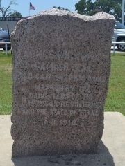
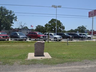
Marker #: 66
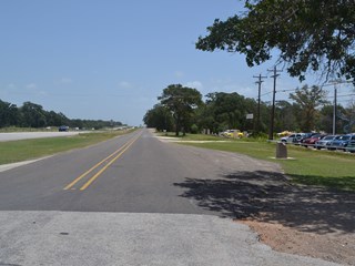
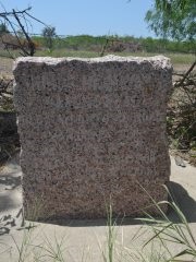
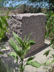
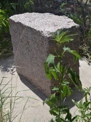
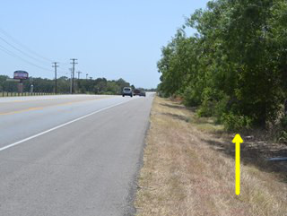
Coordinates: 30.110234, -97.403396 Location: SH 21/71 west of Bastrop Relation to Road: 20 feet from south stripe of south frontage road, facing road, N 350° Distance from post: 0.4 mi. west of post, on route Dimensions: 40" x 29" x 19" Setting: Concrete Other Markers/Signage: No Visibility: High Accessibility: Excellent This marker is on State Highway 21/71 about 0.7 miles east of where the two highways separate. It is on the frontage road on the south side of the main highway. It is in front of a used car lot next to a Ford automobile dealership. There is a wide puloff that affords plenty of space to park and excellent accessibility. The marker is set in a concrete square in a patch of mowed grass. The color and condition of the concrete setting give the impression that it is relatively new. The marker has a wavy top. Additionally, the top right rear corner is missing. It is difficult to determine whether the marker was manufactured without that corner, or whether it was damaged afterward. There are scratches on the face, near the bottom. According to Zively's sketch, the marker was originally placed about 0.4 miles east of its current location. When the Texas Society DAR documented it for their 1995-2001 Old San Antonio Road marker rededication project, it was set in earth, apparently more directly in front of the Ford dealership than it is now, possibly some two to three hundred feet west of its present location. The DAR also noted that the marker was illuminated at night, which is not the case today. A satellite photo from December 1997 shows that the used car lot and the asphalt pulloff at the current marker setting did not exist at that time. The next available satellite photo from December 2002 shows the lot and the pulloff, but the image does not have sufficient resolution to make out whether the marker was there. (Logic suggests that it was, because of the pulloff.) Coordinates for Marker #66's current location were first posted to Wikipedia on 20 May 2005. Observed on July 12, 2014. |
   |
|
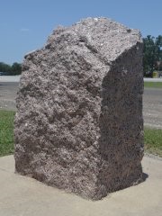
Marker #: 67
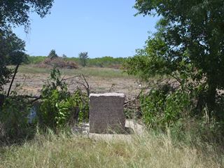
Coordinates: 30.095981, -97.465165 Location: SH 21 east of Cedar Creek Relation to Road: 25 feet from north stripe, facing road, SE 150° Distance from post: 0.1 mi. east of post, on route Dimensions: 28" x 26" x 23" Setting: Concrete Other Markers/Signage: No Visibility: Low Accessibility: Excellent in dry weather This marker is on Highway 21, 3.2 miles west of its junction with Highway 71 and 2.3 miles east of the town of Cedar Creek. It is about 0.2 miles west of McDonald Lane and is across the highway from the parking lot for the Bastrop Independent School District's Memorial Stadium. The marker is on the north side of the highway, in tall grass, weeds, and brush in a ditch in front of the fence line. The marker is difficult to spot from the highway because it is in a low position relative to the road, and because the brush obscures it from the sides. The wide highway shoulder offers excellent accessibility in dry weather, but after a rain, accessibility could be hampered by water in the ditch. The marker is set in concrete. It is clean except for some lichens on the rear. This marker is close to its original survey location. While it is possible that it is at its exact original location, a close study of Zively's sketch indicates that it has probably been moved east about 500 feet. This marker was set in earth when the Texas Society DAR documented it between 1995 and 2001. Their photograph of the marker's face shows some uneven weathering, which is characteristic of markers that sank into the ground and then were dug up and reset at a higher level. Therefore, it had probably already been reset at least once when their photograph was made. Other than this, the site in their photograph looks very similar to ours. According to their notes, the marker was 4.5 miles west of Highway 71, or about 1.3 miles west of where it is now, but this is surely a mistake, as the Bastrop County Historical Commission recorded it in 1975 as being "2 miles E Cedar Creek," which, accounting for rounding, is where it is now. Observed on July 12, 2014. |
   |
|
Marker #: 68
Coordinates: N/A Location: Not found This marker was surveyed about 3.2 miles west of Cedar Creek, or about 5.1 miles east of the Bastrop-Caldwell County line. Its survey location is on a section of Zively's route that does not quite correspond with Highway 21 and is no longer on a public road. A private road does pass through the area; the original survey post location would have been about 165 feet down this road. The corresponding pink granite marker has not been found. Observed on July 12, 2014. |
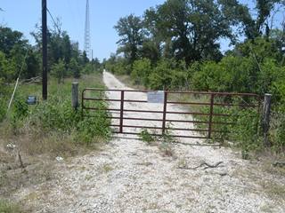
Above: Zively's survey post #68 was placed approximately 165 feet down this private road.
|
- Carson, David - field notes observed and recorded in 2014
- Zively, V.N. - "Field Notes and Detail Map of the Kings Highway", 1916