
The Old San Antonio Road Posts and Markers in Hays and Caldwell Counties
The Old San Antonio Road Posts and Markers in Hays and Caldwell Counties
- Map of the Old San Antonio Road in Hays and Caldwell Counties
- Marker #71
- Marker #72
- Marker #73
- Marker #74
- Marker #75
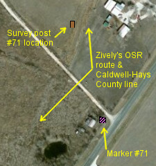
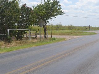
This map shows five Old San Antonio Road markers that are in Hays County or near the Caldwell-Hays County line. All five OSR survey posts were originally placed in Hays County; four on the Hays County side of the county line, and one inside Hays County. Two of the county line markers have since been moved to the Caldwell County side of the line, and another one has been moved further inside Hays County, away from the county line. The fourth county line marker has not been moved.
The fifth marker, which was placed inside Hays County, has also been moved a short distance.
All five markers are still on Zively's route.
Map of the Old San Antonio Road in Hays and Caldwell Counties
[-]Collapse Map [+]Expand Map
|
Marker #: 71
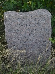
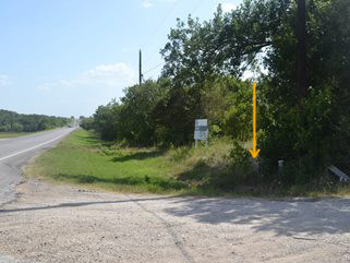
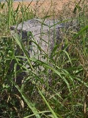
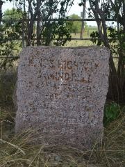
Coordinates: 29.982066, -97.763209 Location: SH 21 between Niederwald and Uhland (Caldwell County) Relation to Road: 35 feet from north stripe, facing road, SE 130° Distance from post: 400 feet south of post, on route Dimensions: 31" x 28" x 13" Setting: Concrete Other Markers/Signage: No Visibility: Low Accessibility: Fair This marker is about halfway between Niederwald and Uhland on Highway 21. It is 1.4 miles southwest of Farm-to-Market Road 2001. It is at the corner of a short gravel road that leads to some rural residences. It is in front of the fence line under a tree and is overgrown by tall weeds and shrubs. It is difficult to spot. The only parking available is on the narrow highway shoulder or the narrow gravel road. The site looks like it is prone to holding water after a rain, even further impeding accessibility. The marker is set in concrete. A black, powdery substance applied to the lettering to make the engraving easier to read has almost completely worn off. Highway 21 deviates from Zively's route by a few hundred feet in this area. Zively's route can be made out in aerial photos, and can also be seen on the ground, where there is a barbed-wire fence running along a raised bed of earth that must have been the old roadbed.1 The marker has been moved to the public highway, but it is only about 400 feet from its original location, and only about 250 feet from Zively's route. When the distance between the marker and Zively's route is that small, we classify it as being on his route. Observed on July 12, 2014. |
|
|
Marker #: 72
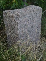
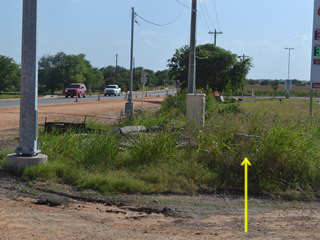
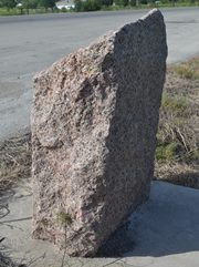
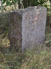
Coordinates: 29.934476, -97.818236 Location: SH 21 southwest of Uhland (Hays County) Relation to Road: 52 feet from north stripe of SH21, facing into intersection, E 110° Distance from post: At post Dimensions: 31" x 29" x 19" Setting: Concrete Other Markers/Signage: No Visibility: Low Accessibility: Poor This marker is at the east intersection of SH 21 and FM 150, halfway between the town of Uhland and the San Marcos Municipal Airport. At the time of our visit, this intersection was being widened, and the entire area was coned off, with no safe place to park except for a gas station some 50 to 100 feet away, requiring a walk through some tall grass and weeds. The marker is on a thick concrete base. It is turned to face into the intersection at a 45 degree angle. The left side of the marker is substantially thicker than the right side. Its depth is 19 inches and 11 inches, respectively. The lettering has been darkened with a black, powdery substance to make the engraving more readable. Some of this substance has eroded away, but most of it is still present. This marker is at its original location. Fortunately, it is far enough from the road that it looks like it will not need to be disturbed for the ongoing construction work. When the project is completed, the marker will be closer to the road than it is now, and its visibility and accessibility may also be improved. Observed on July 12, 2014. |
 |
|
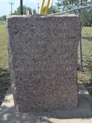
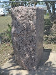
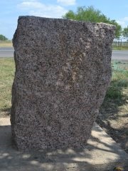
Marker #: 73
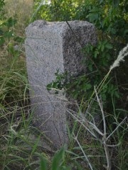
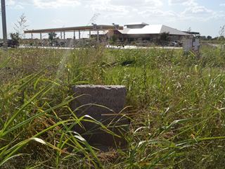
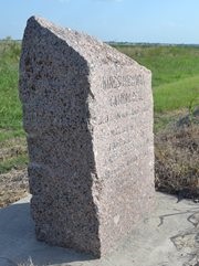
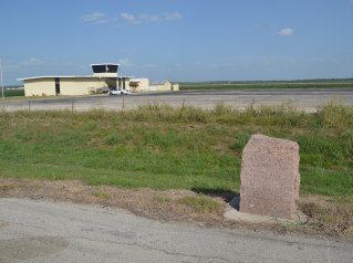
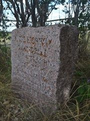
Coordinates: 29.902699, -97.867914 Location: SH 21 at the San Marcos Municipal Airport (Caldwell County) Relation to Road: 40 feet from south stripe, facing road, NW 300° Distance from post: 0.9 miles northeast of post, on route Dimensions: 32" x 28" x 15" Setting: Concrete Other Markers/Signage: No Visibility: High Accessibility: Excellent This marker is on Highway 21 at the San Marcos Municipal Airport. It is 2.9 miles northeast of Highway 80 and 2.3 miles southwest of FM 1966. It is near a one-story office building at the northern end of the airfield. The marker is easy to spot and to access thanks to a very large asphalt pulloff that takes you right up to the marker, without having to walk through the grass. The marker slopes down sharply from back to front. The rear side is 42" tall, whereas the face is 32" tall. The lettering has been darkened to make the engraving easier to read. This effect has partially worn off. The bottom of the marker's face looks dirty. According to Zively's sketch, this marker was originally placed about 0.9 miles southwest from its current location, approximately where a local road called Airport Drive intersects the highway. The reason for it being moved is not apparent. Observed on July 12, 2014. |
 |
|
Marker #: 74
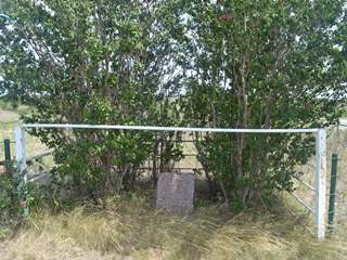
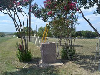
Coordinates: 29.842490, -97.913034 Location: Old Bastrop Highway south of the San Marcos River (Hays County) Relation to Road: 18 feet from southeast stripe, facing road, NW 310° Distance from post: 1.4 miles southwest of post, on route Dimensions: 29" x 27" x 14" Setting: Dirt and rocks Other Markers/Signage: No Visibility: Medium Accessibility: Good This marker is near the intersection of Old Bastrop Highway and Staples Road, which is also known as Hays County Road 621. It is just north of the intersection, on the southeast side of Old Bastrop Highway. It is inside a strange, white painted metal structure that consists of a pen on the sides and rear and a header bar across the front. Most adults who want to get close enough to the marker to touch or examine it will have to stoop under the header bar. There is no parking directly in front of the marker, except for the narrow, steep grass shoulder, but there is a wide, flat, cleared dirt area off to the side. This area appears to be on public land and makes a good parking place. Two crepe myrtle trees are inside the pen with the marker. These trees reduce the marker's visibility from the road. If one knows to be looking for a white metal pen, the marker is easy to spot. The marker is set in dirt and rocks. There does not appear to be any concrete underneath. The marker is covered in tree residue, which has collected inside some of the engraving and made it more readable. A black powdery substance added to the engraving some time ago has mostly worn off. Zively placed the survey post for this marker "on the South Bank of the beautiful San Marcos River," about a mile and a half northeast of this location. Today, there are three historical markers approximately where Zively placed his survey post, so it would seem simple enough to move this marker to be with them. Observed on August 2, 2014. |
 |
|
Marker #: 75
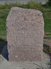
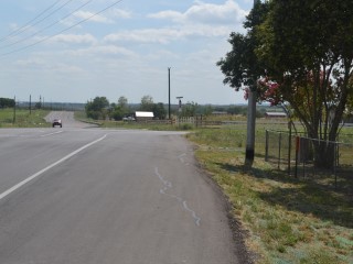
Coordinates: 29.813210, -97.967469 Location: Old Bastrop Highway southwest of San Marcos (Hays County) Relation to Road: 18 feet from northwest stripe, facing road, SE 150° Distance from post: 0.4 miles southwest of post Dimensions: 36" x 27" x 14" Setting: Concrete Other Markers/Signage: No Visibility: Medium Accessibility: Excellent This marker is at the intersection of Old Bastrop Highway (Hays CR 266) and Centerpoint Road (Hays CR 234). It is on a mowed utility easement on a residential lot, just outside the homeowner's chain-link fence. The highway shoulder widens at the intersection, allowing ample room to park. The marker is set in concrete below a utility pole. There are crepe myrtle trees on either side of the marker - one on the easement, and the other inside the homeowner's fence. The top and rear of the marker have tree residue on them, but the face is surprisingly clean. The lettering has trace amounts of a black powdery substance added to it at one time to enhance readability; the black has mostly worn off. This marker appears to be about 0.4 miles southwest of the location noted on Zively's survey. It is on his surveyed route. Observed on August 2, 2014. |
 |
1The old road is shown on a Caldwell County road map from 1940. A 1961 road map shows both roads, but with part of the earlier road missing.
- Carson, David - field notes observed and recorded in 2014
- Zively, V.N. - "Field Notes and Detail Map of the Kings Highway", 1916