
The Old San Antonio Road Posts and Markers in Comal County
The Old San Antonio Road Posts and Markers in Comal County
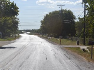
- Map of the Old San Antonio Road in Comal County
- Marker #76
- Marker #77
- Marker #78
- Marker #79
- Marker #80
Zively placed five oak survey posts in Comal County. All of their matching granite markers have been found. Four of these are at or near their original positions. The fifth one was moved in the early 21st century, but remains on Zively's route.
Map of the Old San Antonio Road in Comal County
[-]Collapse Map [+]Expand Map
|
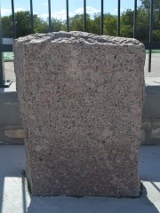
Marker #: 76
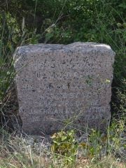
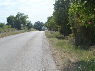
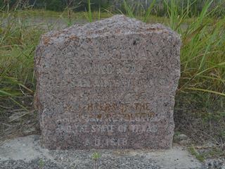
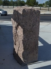
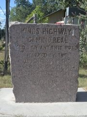
Coordinates: 29.794372, -98.013933 Location: Old Bastrop Road at the Comal-Hays County line Relation to Road: 9 feet from north stripe, facing road, S 160° Distance from post: At post Dimensions: 31" x 28" x 13" Setting: Rock Other Markers/Signage: No Visibility: Low Accessibility: Medium This marker is on Old Bastrop Road near the Comal-Hays County line. This road is maintained as County Road 266 on the Hays County side. A small, white sign reading "Comal County Maintenance Begins" and a transition in the road surface are the only indicators of a county boundary. The marker is not easy to see at all; it is on the fence line on the north side, in a ditch, surrounded by brush, about 100 feet on the Comal County side of the white road sign. There are some utility poles almost directly across the road from it. It is 0.5 miles east of York Creek Road and 1.2 miles west of Francis Harris Lane. The grassy shoulder is helpful for parking, but it isn't wide enough to allow a full-size vehicle to pull completely off the road. Fortunately, this area receives very little traffic. The marker is set in a bed of white rock that is surrounded by landscape timbers. Two crepe myrtle trees are planted on either side of the area. Some other shrubs were planted around the marker, and some miscellaneous vegetation has grown up with it, as the area has not been kept up. Traces of a black, powdery substance once applied to the lettering to make the engraving easier to read can still be seen. The marker is covered in tree residue. This marker is at or near its original location. Observed on August 2, 2014. |
|
|
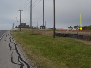
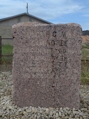
Marker #: 77
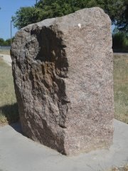
Coordinates: 29.759950, -98.049333 Location: I-35 northeast of New Braunfels Relation to Road: 109 feet from north stripe, facing road, SE 130° Distance from post: 2.1 miles northeast of post, on route Dimensions: 25" x 33" x 14" Setting: Concrete and gravel Other Markers/Signage: Yes Visibility: Low Accessibility: Medium This marker is on the north frontage road of Interstate 35 northeast of New Braunfels. It is 0.6 miles south of W Watson Lane and 1.0 miles north of Kohlenberg Road. It is on a hill on the north side of some communications towers, which are adjacent to highway mile marker 194. The frontage road is two-way, so visitors coming from New Braunfels can use the Kohlenberg Road exit. The marker is in a field in front of a pasture fence. It is set in a concrete base, which is surrounded by gravel, tall grass, and weeds. It is over 100 feet from the road. A brown "historical marker" sign points to it from the frontage road. As of October 2014, this area was under construction. A dirt driveway led past the marker to a small construction site. The marker was behind an orange plastic construction fence, which did not prevent visitors from approaching the marker, but was probably there to set it apart from the construction area and keep it safe from heavy equipment. The stone itself is set deep in the ground, buried all the way to the bottom edge of the lettering on the face. There is rusty-colored tree residue on all of its surfaces. This marker was moved to this location between 2005 and 2008. Previously, it had been further south on Interstate 35, on the northbound frontage road, about 0.7 miles north of FM 306, in front of a wire farm fence.1 Other than being on the wrong side of the highway and facing the wrong direction - all OSR markers were originally placed on the southbound side of the road - it was essentially at the same location where Zively placed his oak survey post. The Daughters of the American Revolution documented it there for their 1995-2001 OSR marker rededication project. Geographic coordinates matching the location the DAR described and photographed were posted to Wikipedia on July 9, 2005. Google Street view photos of that site show that by March 2008, the marker had been removed. It was photographed at its current location by Steve and Marion Daughtry of Round Rock, Texas on September 20, 2008. The marker's concrete setting looked new in their photograph. The site of the marker's old location has not changed much since 2005 - i.e., the road has not been widened, there hasn't been any commercial development, etc. The owner of the farm adjacent to the marker's old location said in 2014 that she remembered that the city of New Braunfels dug up the area to install a water line, but she could not remember whether that occurred during the time period that the marker was removed. So, without any further speculation about who moved the marker or why, it is worth noting that while it is now quite far from the original survey post location, it is still on Mr. Zively's route and is now on the proper side of the road, with the correct orientation. Observed on October 19, 2014. Update: As of September 5, 2015, the marker's accessibility and visibility were both poor. The marker was hidden behind piles of earth and rock, weeds had grown up around it, and wooden construction signs obscured it, but it was still there. |
 |
|
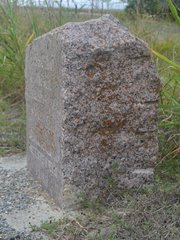
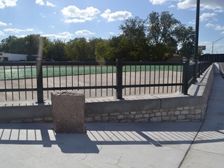
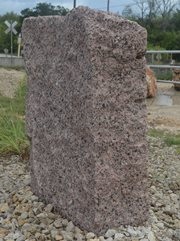
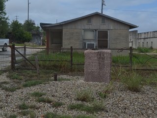
Marker #: 78
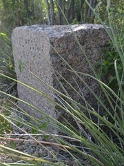
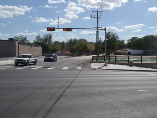
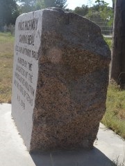
Coordinates: 29.695467, -98.113737 Location: Nacogdoches Road in downtown New Braunfels Relation to Road: 27 feet from north curb, facing into the intersection, E 100° Distance from post: At post Dimensions: 35" x 28" x 15" Setting: Concrete Other Markers/Signage: No Visibility: High Accessibility: Good This marker is at the intersection of Nacogdoches Road and Seguin Drive (also called Spur 46) in New Braunfels. It is set in a concrete sidewalk in front of a painted green metal bar fence. The marker is oriented at a 45-degree angle relative to the street, so that it faces into the center of the intersection. The concrete slopes down from left to right, but the marker is level, so the right side is taller than the left side. It is easy to spot. There is no street parking, but there is a large public parking lot for the county appraisal district across Nacogdoches Road. This marker is at its original location, but its current setting is brand new - completed during the summer of 2014. The large lot behind the fence - currently a level bed of dirt and rock - is under development. Observed on August 23, 2014. |
 |
|
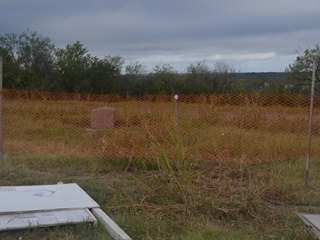
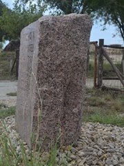
Marker #: 79
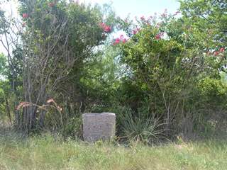
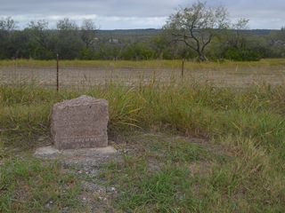
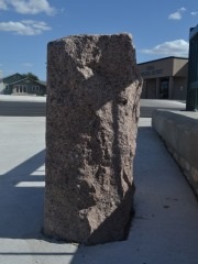
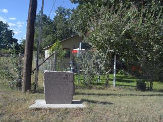
Coordinates: 29.662083, -98.186333 Location: FM 482 in southwest New Braunfels Relation to Road: 17 feet from north stripe, facing road, S 160° Distance from post: At post Dimensions: 29" x 28" x 14" Setting: Concrete Other Markers/Signage: No Visibility: Medium Accessibility: Good This marker is on Farm-to-Market Road 482 2.1 miles southwest of Loop 337 in New Braunfels. It is 1.0 miles west of Solms Road and about 300 feet east of Rusch Lane. The marker does not stand out from its surroundings, but it is easy to spot, if you are looking for it. It is on a utility easement in front of a house. It is in front of the homeowner's fence and across a ditch. There is no dedicated parking area, but finding temporary street parking nearby should not be a problem. As always, folks who visit markers this close to a residence are urged to show respect for the homeowners' space and privacy. This marker's face has a unique appearance. The lettering appears to be slightly larger and more rounded than is typical for these granite OSR markers. Additionally, while the face of most OSR markers is polished and glossy, this one looks flat and unreflective. It could have been manufactured differently from the others, or it could have been altered since it was placed; the latter explanation seems more likely. As a final observation, the square concrete base looks quite new. The marker has obviously been reset since it was originally placed, but otherwise, it appears to be at its original location. Observed on August 23, 2014. |
 |
|
Marker #: 80
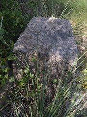
Coordinates: 29.638384, -98.260415 Location: Old Nacogdoches Road in Garden Ridge Relation to Road: 47 feet from north edge, facing road, SE 140° Distance from post: At post Dimensions: 31" x 26" x 13" Setting: Rock Other Markers/Signage: No Visibility: Medium Accessibility: Fair This marker is on the grounds of the Hansen Servtex limestone quarry on the east side of the city of Garden Ridge. It is on Old Nacogdoches Road, 0.3 miles east of that road's junction with FM 2252. It is on the west side of some private railroad tracks used by the quarry. The marker sits on a bed of rock on the north side of the road, in front of a small office building. The marker is in a location where there are many large stones and boulders on the ground, so it is easy to miss it. There is room to pull over on the side of the road. A part of the marker's face has been stained by something black. A cavity on the top of the marker, above the face stain, is similarly discolored. This would suggest that a dark liquid settled into the cavity and then overflowed it, dripping down the front. Whatever it was, it happened long ago. Photographs show that as late as March 2013, the area this marker is in was easily accessible to visitors. Sometime between March 2013 and August 2014, however, a brown painted metal pipe fence was placed between the OSR marker and the road. This fence both discourages and impairs - but does not prevent - visitors from approaching the marker. Whether or not approaching the marker would be considered trespassing is a question TexasCounties.net cannot answer.2 This marker is at or near its original location. Observed on August 23, 2014. |
 |
1The geographic coordinates of its previous location are 29.735117, -98.0703.
2From our layman's point of view, judging from the placement of the nearby utility poles, the marker appears to be on a utility easement. A "private property" sign on the fence behind the marker gives the impression that, and not the new fence in front of the marker, is where the restricted area begins. The new fence is not difficult to go through, over, or around. Nevertheless, the new fence sends an obvious message that the general public is meant to stay away. While we at TexasCounties.net fully support the rights of property owners to restrict access to their land, we also fully support the rights of citizens to access public property. Unfortunately, we do not have enough information to know which set of rights prevail in this instance.
- Carson, David - field notes observed and recorded in 2014
- Zively, V.N. - "Field Notes and Detail Map of the Kings Highway", 1916
- Texas Society Daughters of the American Revolution - Old San Antonio Road DAR Marker Information Site