
The Old San Antonio Road Posts and Markers in North Bexar County
The Old San Antonio Road Posts and Markers in North Bexar County
- Map of the Old San Antonio Road in North Bexar County
- Marker #81
- Marker #82
- Marker #83
- Marker #84
- Marker #85
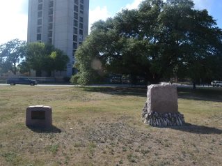
Zively placed nine Old San Antonio Road oak survey posts in Bexar County. Five were placed in the northern part of the county shown on this map. All of the matching pink granite markers have been found. All of them are close to their original locations and are still on Zively's route, although at least three of them have been moved up to 0.2 miles.
Map of the Old San Antonio Road in North Bexar County
[-]Collapse Map [+]Expand Map
|
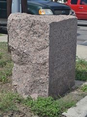
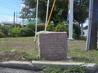
Marker #: 81
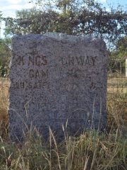
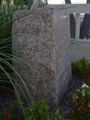
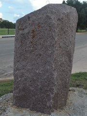
Coordinates: 29.604217, -98.328317 Location: Nacogdoches Road at Cibolo Creek Relation to Road: 26 feet from north curb, facing road, SE 150° Distance from post: At post Dimensions: 28" x 23" x 14" Setting: Dirt and grass Other Markers/Signage: No Visibility: Low to Medium Accessibility: Fair This marker is on Nacogdoches Road / FM 2252 on the west side of Cibolo Creek, which is the Bexar-Comal County line. Evans Road, which did exist when Zively made his survey in 1915, follows the west bank of the creek, and the marker is on the west side of Evans Road. Even though Zively did not note Evans Road on his sketch, it seems more likely that he placed his survey post on the west side of Evans Road, rather than between the road and the creek. In other words, the granite marker is probably extremely close to where Zively placed his survey post. The marker is on a ridge on a fence line next to a utility pole and some other equipment. Its visibility is reduced by these other objects, which partially obscure the view of the marker from the road. The highway is curbed, and there are no shoulders, so the only possible parking availability in front of the marker is a bicycle lane that isn't wide enough for four-wheel vehicles. There is a smooth, 3-foot high concrete incline to walk up if approaching the marker from the front. Another parking option, allowing more room but requiring a longer walk, is a wide patch of gravel on the opposite side of Evans Road. Either way, accessibility is fair. The marker sits in earth, and does not appear to have a concrete layer beneath the surface. There is a greenish-white mineral substance on top of the marker. It is like chalky clay, only it is hard and stuck tightly to the granite. Observed on August 23, 2014. |
|
|
Marker #: 82
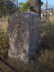
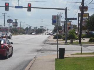
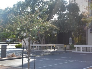
Coordinates: 29.563304, -98.391343 Location: Nacogdoches Road in northeast San Antonio Relation to Road: 9 feet from north curb, facing road, SE 130° Distance from post: 0.2 miles northeast of post, on route Dimensions: 30" x 29" x 14" Setting: Concrete Other Markers/Signage: No Visibility: High Accessibility: Excellent This marker is at the intersection of Nacogdoches Road / FM 2252 and Higgins Drive in northeast San Antonio. It is in front of a vacant lot formerly occupied by a gas station. It is in a small concrete rectangle in the grass next to a traffic signal pole and utility pole. The marker is easy to find and see, and accessibility is excellent. There is a small rust stain on top of the stone, but it is otherwise clean and free of surface defects. Some of the streets in northeast San Antonio, such as Evans Road and Judson Road, date back to the 19th century, but Higgins Road is not one of them. Based on Zively's survey, it appears that he placed his survey post about 0.2 miles southwest of its current location - perhaps halfway between Longfellow Boulevard and Wordworth Street. The marker was probably moved to its present street corner location when this part of Nacogdoches Road was being developed. The Texas Society Daughters of the American Revolution's photo of the site, made between 1995 and 2001, shows the marker at this location. It appears to be further further from the sidewalk, but it appears that the intersection has been altered since then, rather than the marker being moved. Observed on September 20, 2014. |
 |
|
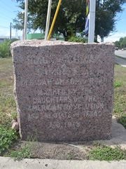
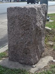
Marker #: 83
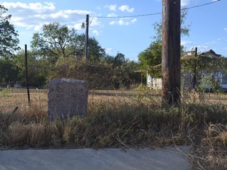
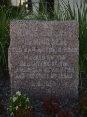
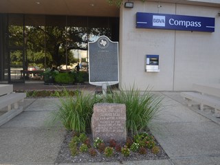
Coordinates: 29.515267, -98.453583 Location: Nacogdoches Road at I-410 in San Antonio Relation to Road: 241 feet from northwest curb of Nacogdoches Rd, facing away from the office building, E 80° Distance from post: 0.1 mile southwest of post, on route Dimensions: 28" x 24" x 14" Setting: Concrete Other Markers/Signage: Yes Visibility: Low Accessibility: Excellent This marker is on the property of the bank and office building at 1100 NE Loop 410, near Nacogdoches Road. It is in a small landscaped area in front of the bank's east lobby entrance. The marker is set in concrete, covered with a few inches of dirt and mulch. There are two grassy shrubs behind it, and a patch of begonia plants in front. There is a metal state historical marker behind the granite marker. Since this marker isn't near the street, like most OSR markers are, it can be tricky to find. It doesn't help that some nearby fences block it from being seen at an angle. Unless you know where to look, or happen to walk or drive right past it, you might never see it. Fortunately, the historical marker sign sticks up over the fences, and is easier to spot. Ample parking is close by. This marker has certainly been moved to this location, but it probably has not been moved far. Nacogdoches Road does not appear to follow exactly the same path in this area that Zively surveyed. Our best guess is that his survey post was originally placed directly underneath the middle of what is now the I-35 overpass. If so, it has been moved about a tenth of a mile from its original location, but it is close enough to Nacogdoches Road to be considered still on Zively's route. The historical marker commemorates El Camino Real. It explains the road's founding as a mission trail, its use during the 19th century, and its preservation by the Daughters of the American Revolution. The historical marker sign is dated 1979, which could be when the granite marker was moved to this location. Observed on September 20, 2014. |
 |
|
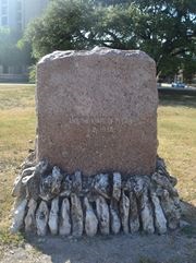
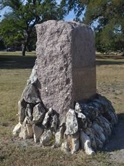
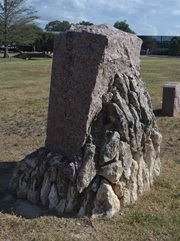
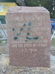
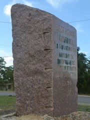
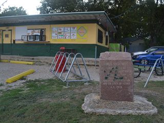
Marker #: 84
Coordinates: 29.446017, -98.503417 Location: San Pedro Park in downtown San Antonio Relation to Road: 114 feet from east curb, facing away from road, E 100° Distance from post: 0.1 mile south of post, on route Dimensions: 54" x 39" x 20" Setting: Concrete Other Markers/Signage: Yes Visibility: Medium Accessibility: Good This marker is in San Pedro Park on the north side of downtown San Antonio. It is in a flat, open, grassy area close to the intersection of North Flores Street and Hickman Street. There is room to park on Flores Street. The marker is easy to spot. There are no sidewalks or improved trails, so because of the flat expanse of grass to walk over, accessibility might be impaired after a heavy rain. Otherwise, accessibility is excellent. The area around San Pedro Springs was where San Antonio was first settled. It is the center of the Old San Antonio Road, and possibly the single most historically important spot on it. This gives Marker #84 a special status, and so it is where, on March 2, 1918, the Texas Society DAR formally presented the Old San Antonio Road to the state of Texas. Claudia Norvell, the DAR chapter chair who conceived and coordinated the OSR project, spoke at the occasion, which was also attended by state and local politicians and historians. The ceremony featured an 18-by-18-foot canvas map of Texas, with the route of the Old San Antonio Road painted in red, and the 123 granite markers painted in black. No doubt because of its unique ceremonial status, the marker itself is conspicuously different from the other 122 granite OSR markers in two respects. First is its size. It stands twice as high out of the ground and is half again as wide and deep as the other markers. Without knowing how much of Marker #84 is underground, it has to be at least six times more massive than the average OSR marker. The other difference is that it is encased in a frame consisting of rows of rocks that have been cemented in place. The engraving on the marker's face is identical to the others. The face of this marker is in poor condition. The area around the lettering has been badly abraded, removing the polish as well as some of the engraving itself. It appears to have been done deliberately, perhaps as an extreme but necessary response to an act of vandalism. This effect is just as noticeable in the DAR's photo, made in 1997, as it is now. In addition, there is a small vertical crack at the top of the face. A second, small granite marker has been placed near the OSR marker. This marker commemorating El Camino Real was placed by the American Society of Civil Engineers in 1986.1 Based on Zively's survey, it appears that the Old San Antonio Road crossed the northwest corner of San Pedro Park at approximately a 45-degree angle, intersected with Flores Street approximately at Weymouth Street, and then turned due south, following Flores. Zively placed his survey post where the route changed direction, which is approximately where Weymouth Street intersects with Flores. If that is the case, the marker is now about a tenth of a mile south of the surveyed location. It may well have been moved there some time after the original dedication ceremony, for the DAR's records note that the service took place "under the boughs of giant trees." There are several clusters of large trees all around the park, including at the original survey location, but the marker's present location is treeless. Observed on September 20, 2014. |
 |
|
Marker #: 85
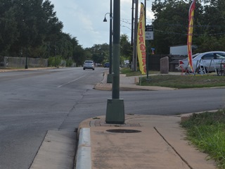
Coordinates: 29.378283, -98.489167 Location: Mission Road in downtown San Antonio Relation to Road: 47 feet from north edge, facing road, SE 140° Distance from post: At post Dimensions: 31" x 26" x 13" Setting: Concrete Other Markers/Signage: No Visibility: Medium Accessibility: Excellent This marker is on the southwest bank of the San Antonio River, at the corner of Mission Road and East Hart Avenue south of downtown San Antonio. It is in front of a neighborhood food stand. Parking is available on Hart Avenue or, if you feel like getting a snack, at the business's customer parking lot. The face of the marker has recently been vandalized with green spray paint. According to the business owner, this occurred in about July 2014. This marker is at or near its original location. Observed on September 20, 2014. |
 |
1The inscription on the plate reads "El Camino Real The Kings Highway Eastern Branch." "Eastern Branch" is the ASCE's way of distinguishing the Spanish royal road that went through Texas - El Camino Real de los Tejas - from the "Central Branch" that went through New Mexico.
- Carson, David - field notes observed and recorded in 2014
- Zively, V.N. - "Field Notes and Detail Map of the Kings Highway", 1916
- Texas Society Daughters of the American Revolution - Old San Antonio Road DAR Marker Information Site