
The Old San Antonio Road Posts and Markers in South Bexar County
The Old San Antonio Road Posts and Markers in South Bexar County
Also see The Old San Antonio Road in South Bexar CountyZively placed nine Old San Antonio Road oak survey posts in Bexar County. Four were placed in the southern part of the county shown on this map. All four markers still exist. The three in San Antonio are close to their original locations. The marker south of San Antonio has been moved over two miles, but it is still on Zively's route.
Map of the Old San Antonio Road in South Bexar County
[-]Collapse Map [+]Expand Map
|
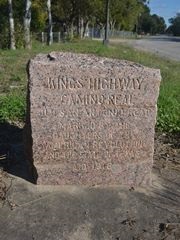
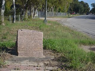
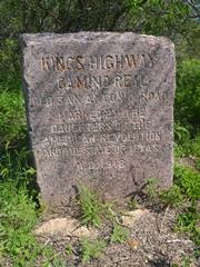
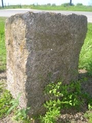
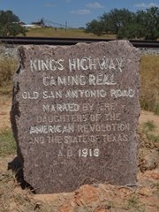
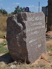
Marker #: 86
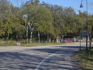
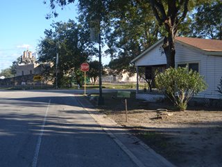
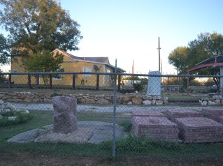
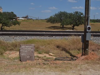
Coordinates: 29.320895, -98.455218 Location: Espada Road at IH 410 Relation to Road: 26 feet from north curb, at a right angle to the road, SE 150° Distance from post: 0.3 mi northwest of post, on route Dimensions: 28" x 23" x 14" Setting: Dirt and grass Other Markers/Signage: No Visibility: High Accessibility: Excellent This marker is at the intersection of Espada Road and "Old Espada Road," about 80 yards south of Interstate 410 South in San Antonio. It is at the end of a large paved shoulder. The marker is set in concrete and surrounded by grass. It is oriented at a right angle to Espada Road, so that it faces the direction of travel. This marker was originally placed about 0.3 miles further southwest, within a stone's throw of Mission Espada. According to Zively's survey, it would have been on the property now occupied by the white house on the street corner shown in the photo at bottom right. Observed on November 8, 2014. |
   Below: Original survey location of Marker #86. Mission Espada can be seen in the background, on the left.
|
|
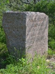
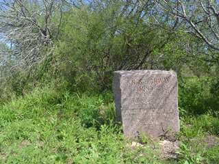
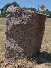
Marker #: 87
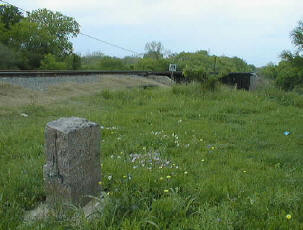
Coordinates: 29.289899, -98.502535 Location: Pleasanton Road, west of Mitchell Lake. Relation to Road: 28 feet from east edge, at right angle to road, S 180° Distance from post: Near post Dimensions: 29" x 26" x 15" Setting: Weeds and brush Other Markers/Signage: No Visibility: Low Accessibility: Medium This marker is on Pleasanton Road, west of Mitchell Lake. It is 0.4 miles north of Mauerman Road, halfway between a bridge over the edge of Mitchell Lake's bed and a road leading to a shooting range. The marker is on the east side of Pleasanton Road, at the edge of a patch of mesquite brush and weeds. It is impossible to spot from the north and can be difficult to spot from the south. There is a shoulder of level grass where one can pull off the road. When we visited the site in November 2014, the tall grass contained surprising amounts of debris, branches, and barbed wire, making the short walk from the road to the marker rather difficult. When we returned in March 2015, the area had recently been mowed and was considerably easier to cross over. The face of the marker, which is oriented at a 90-degree angle to the road, has many small scratches and some large, discolored abrasions. There is a concrete setting beneath a layer of earth. This could mean that the marker has sunk since it was last set. The marker was originally placed on the west, or southbound, side of Pleasanton road, slightly north - that is, within 100 feet - of its current location. The Texas Society Daughters of the American Revolution visited the marker between 1995 and 2001, documenting it here. In their photo, the marker is in front of a cleared, grassy pasture, showing an unobstructed view of the horizon, and with only one tree in the vicinity. A careful comparison of their photo with the marker's current location confirms that the marker has not moved; the area is simply much brushier now. Observed on March 28, 2015. |
 |
|
Marker #: 88
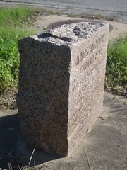
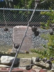
Coordinates: 29.263450, -98.491092 Location: Pleasanton Road south of the Medina River Relation to Road: 210 feet from west side of Pleasanton Rd, facing road, E 80° Distance from post: Near post Dimensions: Not measured Setting: Concrete base resting on top of the ground Other Markers/Signage: No Visibility: Low Accessibility: None This marker is on the south bank of the Medina River, on the east side of a railroad track west of Pleasanton Road. It is on the back, or far west side, of the property at 16030 Pleasanton Road, inside the property owner's chain-link fence. It can barely be seen in the distance from Pleasanton Road. It can be approached by walking to the railroad track and viewing it from the rear, through the fence. The marker is mounted in a concrete setting that has been unearthed and is resting on top of a small patch of pavement. Based on Zively's survey, the Old San Antonio Road crossed the Medina River on present-day Pleasanton Road, then turned southwest, crossing directly through the house now at 16030 Pleasanton Road, and followed Laredo Road. Zively placed the oak survey post for the marker on the west side of the railroad track, on the north side of the intersection of Laredo Road and present-day Leal Street. The granite marker is, therefore, within 150 feet of its original location. When the Texas Society DAR visited Marker #88, it was set in concrete in an open field of grass on the east side of the railroad track, apparently very close to where it is now. At that time, there was a home or business at 16030 Pleasanton Road, but it took up less area, and the yard was not enclosed by a fence. Satellite photos show that the current house and fence were constructed in 2005. The marker has obviously been unearthed since the DAR's visit, but whether it was moved to the inside of the fence, or whether the fence was built around it, is unclear.1 Observed on March 28, 2015. |

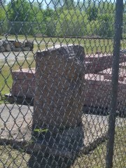 
 Below: The Texas Society DAR's photo of Marker #88.
 |
|
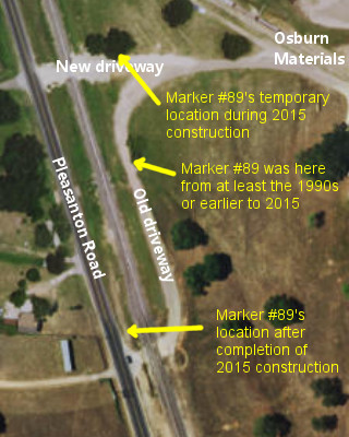
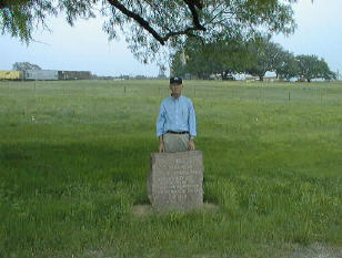
Marker #: 89
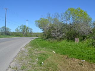
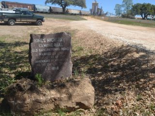
Coordinates: 29.166898, -98.500884 Location: Pleasanton Road north of the Bexar-Atascosa County line Relation to Road: 29 feet from east stripe, facing road, W 260° Distance from post: 2.1 mile south of post, on route Dimensions: 32" x 27" x 16" Setting: Concrete base in dirt Other Markers/Signage: No Visibility: Medium Accessibility: Excellent This marker is on Pleasanton Road about 3.2 miles south of FM 1604 and about 0.4 miles north of Duke Road. It is near the entrance to Osburn Materials, between the railroad and the highway. It is in a concrete base, next to a utility pole. There is a place to park a short distance from the marker. The lettering has been filled in with white paint, making it easy to read. About half of the paint inside the engraving has worn off. A small chunk of the marker's polished face has chipped off. This marker was originally placed on Pleasanton Road about 1.0 miles south of present-day FM 1604. It was moved in front of Osburn Materials sometime prior to 1995. When the Texas Society DAR documented it between 1995 and 2001 for their OSR marker rededication project, both the marker and the entrance to Osburn were in a different place than they are now, however. The small driveway remnant that is next to the marker now, and which serves as a place to park to visit the marker, was at one time part of Osburn's driveway. The driveway crossed the railroad track here, then curved north, paralleled the railroad track for about 500 feet, and then turned west again to enter the business. Marker #89 was inside the curve of this driveway, next to some culverts that carried Gallinas Creek under the driveway and the railroad track. The marker could not be seen from the highway, because of the raised railroad bed. Sometime in the early 2010's, Osburn built a new driveway that passed straight over the railroad, eliminating the S-curve of the old driveway. The marker, which was not moved, was then some 200 feet south of the new driveway. In 2015, the Union Pacific railroad installed a new culvert for Gallinas Creek. This work required that Marker #89 be moved. According to the contractor who performed the work, the marker was excavated on or about February 1, 2015. It was temporarily placed on top of the ground on the north side of Osburn's new driveway. On or around July 1, 2015, the culvert construction was completed. Marker #89 was moved at that time to the side of Pleasanton Road, near Osburn's old driveway entrance. The utility pole next to the marker was installed at the same time as the marker. Observed on August 7, 2015. |
  Below: The Texas Society DAR's photo of Marker #89, made between 1995 and 2001.
 Below: Marker #89 in its temporary setting during construction in 2015.
 |
1Our attempts to contact the current property owner, in person and in writing, were unsuccessful.
- Carson, David - field notes observed and recorded in 2014
- Carson, David - field notes observed and recorded in 2015
- Zively, V.N. - "Field Notes and Detail Map of the Kings Highway", 1916
- Texas Society Daughters of the American Revolution - Old San Antonio Road DAR Marker Information Site