
The Old San Antonio Road Posts and Markers in North Atascosa County
The Old San Antonio Road Posts and Markers in North Atascosa County
- Map of the Old San Antonio Road in North Atascosa County
- Marker #90
- Marker #91
- Marker #92
- Marker #93
Zively placed nine oak survey posts marking the Old San Antonio Road in Atascosa County. Four were placed in the northern part of the county shown on this map. The marker on the Atascosa-Bexar county line is still near its original location. Two other markers have have been moved over a mile from their original locations and are no longer on Zively's route. The fourth marker was last documented on private property in the 1990s, reportedly close to its original location.
Map of the Old San Antonio Road in North Atascosa County
[-]Collapse Map [+]Expand Map
|
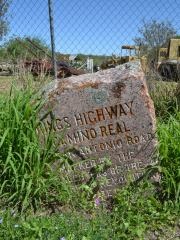
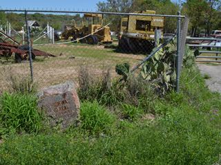
Marker #: 90
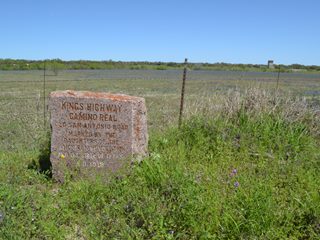
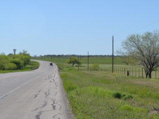
Coordinates: 29.145066, -98.497409 Location: Old Pleasanton Road at the Atascosa-Bexar County line. Relation to Road: 15 feet from east stripe, facing road, W 260° Distance from post: Near post Dimensions: 26" x 26" x 15" Setting: Dirt and weeds Other Markers/Signage: No Visibility: Below average Accessibility: Good This marker is on the Atascosa-Bexar County line on Pleasanton Road, which changes names to Old Pleasanton Road on the Atascosa County side of the line. It is across the street from the Cowboy Crossing subdivision on Spur Ridge Road. It is in front of a chain-link fence for a yard where there is an old farm house and a lot of heavy construction machinery. There is a narrow but solid shoulder for parking. The marker is heavily spotted with light green and rust-colored organic matter. It is in dirt and is partially hidden by weeds. Even though a probe indicates that there is concrete underneath the dirt, the marker has sunk and tilted about 20 degrees to the left. The 26" height measurement reported above is the height of the taller side, which is the right side. According to maps, the marker is about 75 feet south of the county line. On the site photo at right, which looks to the north, the tree on the east side of the road is approximately on the county line. A sign reading "Bexar Co Maintenance Begins" is posted about 100 feet south of the county line and some 30 feet south of the marker. This sign, or one like it, may be the reason that the Texas Society Daughters of the American Revolution considered this marker to be in Bexar County for their 1995-2001 OSR marker rededication project. The DAR researcher noted that it was "20' North of the Bexar/Atascosa County line facing West." In their photo, the marker is in front of an open field. A satellite photo from January 1995 shows that this site was less developed at that time. The marker has probably not been moved since the DAR's visit, but it is definitely more titled now. According to Zively's survey, the marker was originally placed on the west side of Old Pleasanton Road.1 It may have been placed closer to the county line than it is now. Therefore, while it appears to have been moved from its original location, it was not moved far. Observed on March 28, 2015. |
   Below: The Texas Society DAR's photo of Marker #90. 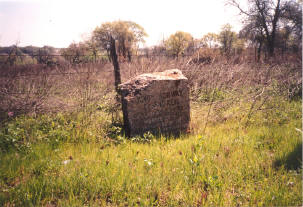 |
|
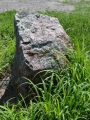
Marker #: 91
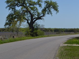
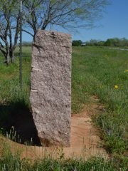
Coordinates: 29.127383, -98.495750 Location: Old Pleasanton Road, south of the Atascosa-Bexar county line. Relation to Road: 13 feet from east stripe, facing road, W 270° Distance from post: 4.2 mi northeast, off route Dimensions: 30" x 30" x 13" Setting: Dirt and weeds Other Markers/Signage: No Visibility: Medium Accessibility: Fair This marker is on Old Pleasanton Road just 1.3 miles south of the Atascosa-Bexar County line and Marker #90. It is at a bend in the road, just beyond the canopy of a large, old oak tree. It near Nottingham Drive and is 0.2 miles south of Oak Krest Road. It is in front of a barbed-wire fence and a cleared meadow. Despite there being some weeds and no signs or pulloff, it is not hard to spot. Parking is somewhat difficult due to the lack of any shoulder. The marker is set in earth, with no concrete or other solid layer underneath. It is coated with rust-colored tree residue, which has settled into the lettering, making it stand out and easy to read. It has a typical shape and is in good condition with no significant defects. Like all other OSR markers, it has a characteristic circular divot, but it is on the right side, rather than the top, which is the divot's usual location. According to Zively's survey, this marker was originally placed about 4.2 miles southwest of its current location, about 0.25 miles from the intersection of present-day Farm-to-Market Road 1470 and Red Barn Road. It was at its present location when the Texas Society DAR documented it between 1995 and 2001. Unfortunately, the marker is no longer on Zively's route. Observed on March 28, 2015. |
 |
|
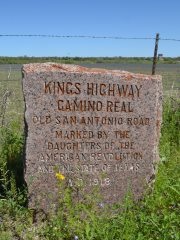
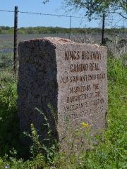
Marker #: 92
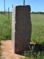
Location: Near Atascosa County Road 304, south of Poteet. Distance from post: 3.3 mi southwest, off route This marker was originally placed on the north bank of the Atascosa River, southeast of Poteet. A local road named Holley Road roughly parallels Zively's route approximately 500 feet to the west. In the past, this was a county-maintained dirt road. It turned eastward just before reaching the river and crossed the river at the same location as the Kings Highway (see the satellite photo at right). The owner of the property on the north side of the river, Mr. Pat Holley, has lived there since 1953. He told us in 2015 that the county ceded the road to him in the 1950s. He installed a gate about a mile from FM 476 and about 0.4 miles from the river in 1967. He said that before the gate was installed, people looking for buried treasure would come out and dig holes on the land. The last 700-800 feet of Holley Road have not carried traffic for 60 years, and it has almost completely disappeared, but is route is marked by a barbed-wire fence all the way down to the river. A concrete culvert, presumably installed by the county before the 1950s, still exists at the historic river crossing. Thanks to the culvert, this remains a favorite spot for deer and cattle to cross the river. Marker #92 was moved from this location long ago, apparently before 1953. It is now about 3.3 miles to the southwest, near Atascosa Couty Road 304. It is on private property. A photograph made by the DAR sometime between 1995 and 2001 shows it set horizontally in concrete under an oak tree. It was confirmed to be at the same location in 2011. According to the DAR's notes, Marker #92 is "about 150' East along the trail from the original location," but the original location, as noted above, was actually at the Atascosa River on what is now Mr. Holley's property. This note means that the marker has probably been moved at least twice. Observed on June 5, 2015. Updated on July 29, 2016 |
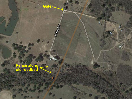 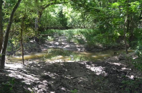 Top: Satellite photo of the original location for Marker #92. The brown line is Zively's route. Above: The historic crossing of the Atascosa River and the site of the original location of Marker #92. Below: The Texas Society DAR's photo of Marker #92, 3.3 miles southwest of its original location. 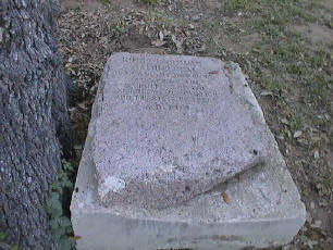
|
|
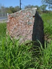
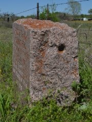
Marker #: 93
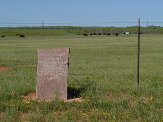
Coordinates: 28.956539, -98.601730 Location: SH 173 northwest of Jourdanton Relation to Road: 46 feet from north stripe, facing road, SW 200° Distance from post: 2.5 miles southwest of post, off route Dimensions: 38" x 25" x 12" Setting: In a concrete base surrounded by dirt and weeds Other Markers/Signage: No Visibility: Medium Accessibility: Very Good This marker is on State Highway 173 northwest of Jourdanton. It is 2.8 miles west of the intersection with SH 16 and is approximately halfway between County Roads 301 and 303/304. It is on the north side of the road at the fence line in front of a nice cow pasture. There is no pulloff, but the shoulder is wide. The fence line and the right-of-way are well-maintained, so the marker is easy to spot. The front of the marker has been shot up by a vandal with a firearm. There appear to be six bullet marks on the marker's face. This damage is apparent in the photo the Texas Society DAR took some time prior to 2001. This marker was originally placed on the north bank of Salt Branch creek, approximately 2.5 miles northeast of its current location. State Highway 16 crosses Salt Branch less than a tenth of a mile east of the marker's original location. Zively's route then west southwest and crossed present-day SH 173 approximately where CR 301 intersects with it now. Either SH 16 at Salt Branch or SH 173 at CR 301 would be more historically accurate locations for the marker. It is now about 0.9 miles west of the closest point along Zively's route. Observed on March 28, 2015. |

 |
1Zively's survey posts were always placed on the right-hand side of the road from the perspective of someone traveling from the Sabine River to the Rio Grande. The granite markers, therefore, should always be found on the north or west side of the road and oriented to face south or east. Throughout east and central Texas, a granite OSR marker found on the east side of the road facing west is a reliable sign that the marker has been moved. In south Texas, however, so few markers are on the "correct" side of the road that it is possible they were installed incorrectly.
- Carson, David - field notes observed and recorded in 2015
- Zively, V.N. - "Field Notes and Detail Map of the Kings Highway", 1916
- Texas Society Daughters of the American Revolution - Old San Antonio Road DAR Marker Information Site