
The Old San Antonio Road Posts and Markers in West La Salle County
The Old San Antonio Road Posts and Markers in West La Salle County
- Map of the Old San Antonio Road in East La Salle County
- Marker #110
- Marker #111
- Marker #112
- Marker #113
- Marker #114
Zively placed eleven oak survey posts for the Old San Antonio Road in La Salle County. Five were placed in the western part of the county shown on this map. The granite markers corresponding to four of those have been found. All four have been moved from their original locations to state highways. The fifth marker has not been found.
Map of the Old San Antonio Road in West La Salle County
[-]Collapse Map [+]Expand Map
|
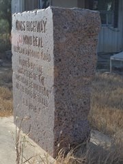
Marker #: 110
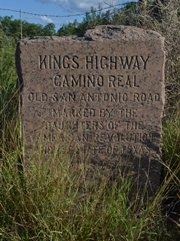
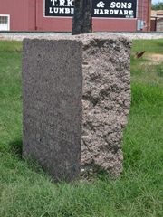
Coordinates: 28.464793, -99.110030 Location: Highway 97 between FM 469 and Cotulla Relation to Road: 32 feet from south stripe, oriented N 340° Distance from post: 4.1 mi northwest of post, off route Dimensions: 36" x 28" x 15" Setting: Broken concrete pedestal. Other Markers/Signage: No Visibility: High Accessibility: Very Good This marker is on Highway 97 about halfway between FM 469 and Cotulla. It is 6.7 miles west of FM 469 and 7.4 miles east of FM 624. It is 2.7 miles west of Brown Road. It is up on a low ridge on the south side of the highway, in front of a field that appears to be an oil lease. There is a wide shoulder for parking. The marker is easy to spot. The marker was mounted on a 12" concrete pedestal like Markers #101, #102, and possibly #108, but as with Marker #102, the earth underneath the pedestal has washed out. The front of the pedestal has broken completely away and now rests on the ground close to the marker. The marker is still attached to the pedestal at the back and sides. In addition to the damage to the pedestal, the face of the marker is also damaged. There is a piece broken off of the top left corner. There is also an asymmetrical gouge below the lettering. It is about the same size as the bullet marks seen on a few other markers, but it has a different shape, and may be from something else. The gloss is also gone from the marker's face. The Texas Society DAR reported this "badly weathered" appearance from their visit made between 1995 and 2001. Their photograph also shows the asymmetrical gouge. The damage to the top left corner had not yet occurred when their photo was made. The pedestal is cropped out of their photograph, and their notes do not mention any damage to it. This marker was originally placed on present-day Altito Road, about 1.2 miles west of Brown Road. It was moved to its current location sometime after 1926, which is when this section of Highway 97 was built. Observed on June 6, 2015. |
|
|
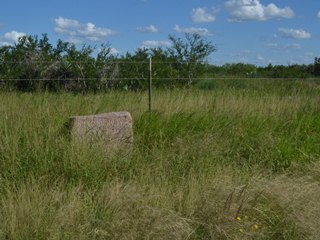
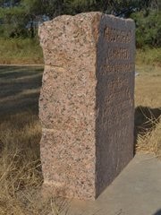
Marker #: 111
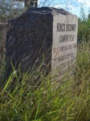
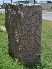
Coordinates: 28.450900, -99.171267 Location: Highway 97 east of Cotulla Relation to Road: 30 ft from south stripe, oriented NW 330° Distance from post: 2.7 mi north of post, off route Dimensions: 31" x 26" x 16" Setting: Concrete among tall weeds Other Markers/Signage: No Visibility: Low Accessibility: Medium This marker is on State Highway 97 four miles west of Cotulla. It is 3.3 miles east of Farm-to-Market Road 624 and 6.8 miles east of Brown Road. It is in the middle of a moderate curve in Highway 97, where the road changes direction from northeast-to-southwest to more closely east-to-west. It is on the right-of-way in front of a barbed-wire fence. There is no pulloff, but there is a narrow asphalt shoulder plus an additional width of gravel, so parking is not difficult, provided you are able to spot the marker in the tall weeds. The marker is in a concrete setting. The setting has separated from the front of the marker, however, similar to how it has separated with Marker #110. (Or, perhaps it was installed this way originally.) Other than the anomaly with the setting, the marker is in excellent condition. This marker was originally placed on present-day Altito Road, 2.9 miles southeast of FM 624. It was probably moved here with or shortly after the construction of this section of Highway 97 in 1926. Observed on June 6, 2015. |
|
|
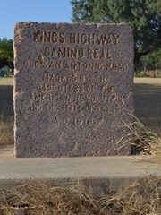
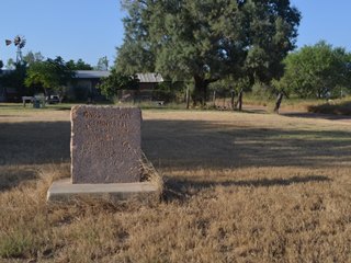
Marker #: 112
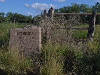
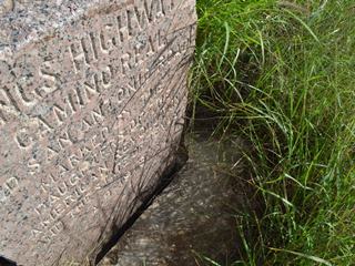
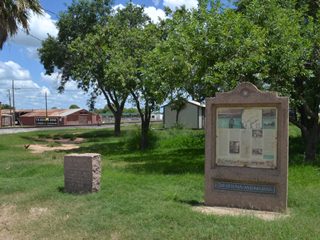
Coordinates: 28.436930, -99.233853 Location: Highway 97 in Cotulla Relation to Road: 18 feet from south edge, oriented N 340° Distance from post: At least 0.7 mi north of post, off route Dimensions: 30" x 27" x 11" Setting: Concrete in grass Other Markers/Signage: Yes Visibility: High Accessibility: Excellent This marker is on the east side of downtown Cotulla, on Highway 97 between Front Street and the railroad track. It is in a green area maintained by the city. There is an Old San Antonio informational display next to it. There is a small pulloff where one passenger vehicle can park in front of it. The marker is clean and has no defects. According to Zively's notes, this marker was originally placed on the north bank of the Nueces River and 170 feet west of the railroad. His sketch incorrectly shows the river and the railroad running nearly parallel to each other, however. In reality, they make about a 45-degree angle with each other. The only place where the railroad comes to within 170 feet of the river is significantly further south than the location marked on his sketch. Ignoring his notes and sketch of the river and focusing exclusively on his sketch of the railroad and the Kings Highway, our analysis indicates that a location near the intersection of S Front Street and Coronado Street, about 1500 feet from the Nueces River, is more likely to be where the marker was originally placed. That location is about 0.7 miles south-southeast of the marker's current location. The marker is now 1.1 miles from the Nueces River. The state of Texas celebrated the 300th anniversary of El Camino Real in 1991 and placed several informational displays along the route, including this one in Cotulla. Marker #112 was moved to its current location at that time. According to several longtime Cotulla residents, the marker was moved from Mustang Creek near Pecos Street. One old-timer stated that the marker was within the banks of the creek and had become partially buried in the mud. No one we spoke with could recall the marker being at any other place, but the location they described is a mile from the Nueces River and over 1,100 feet east of the railroad, so it could not possibly be the same location as the one on Zively's survey. Evidently, Marker #112 was moved early in the 20th century from its original location to Pecos Sreet, which was one of Cotulla's main streets in its early years. The DAR noted that the marker was moved "approximately a mile" when the display was installed, but this is either a gross approximation of the actual quarter-mile distance to Mustang Creek, or a reference to the marker's original location on the south side of Cotulla. Observed on June 6, 2015. |
|
|
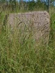
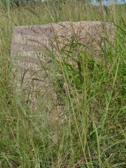
Marker #: 113
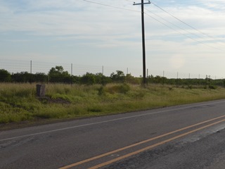
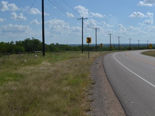
Coordinates: N/A Location: Not found Markers #113 and #114 were placed on a section of the Kings Highway that led from the Cotulla area to a destination Zively labeled as "La Cochina Hill & Ranch owned by J.G. Childers." A road named Cochina Ranch Road exists today in the same approximate location as the route of the Kings Highway drawn by Zively. Zively placed the oak survey post for Marker #113 on this road, approximately 0.3 miles west of present-day Interstate Highway 35. The matching granite marker has not been found. Observed on June 6, 2015. |
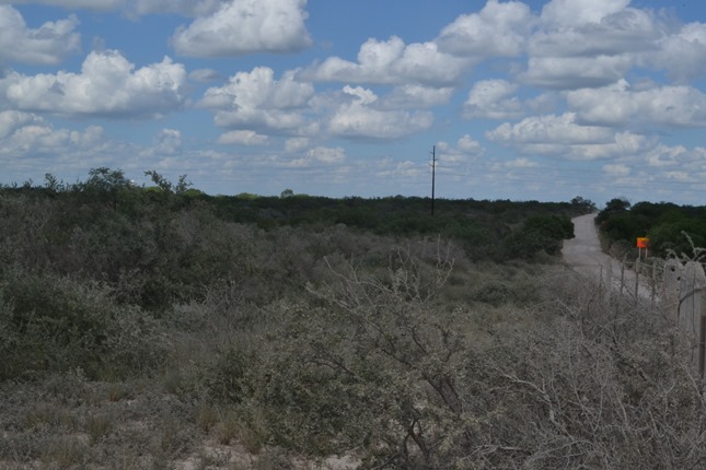 Above: Marker #113 was originally placed at or near this location on Cochina Ranch Road west of Cotulla. |
|
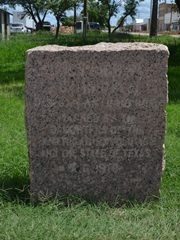
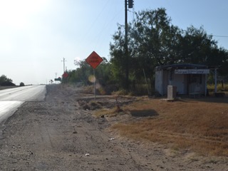
Marker #: 114
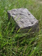
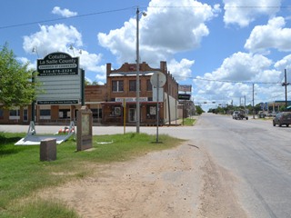
Coordinates: 28.280443, -99.285313 Location: FM 133 west of I-35 near Artesia Wells Relation to Road: 28 feet from north stripe, oriented S 180° Distance from post: 9.0 mi south of post, off route Dimensions: 28" x 25" x 11" Setting: Concrete pedestal Other Markers/Signage: No Visibility: High Accessibility: Excellent This marker is on FM 133 near its intersection with I-35 at Artesia Wells. It is approximately 300 feet west of the west service road for the freeway. It is on the north side of the road, in a grassy lawn next to a food stand that appears to have been abandoned years ago. It is mounted on a concrete pedestal. There is a dirt shoulder for parking. This marker has seen more wear than most. Not only is its gloss completely gone, but its face is worn and chipped in numerous places. This marker is one of the two that were originally placed along Cochina Ranch Road. Marker #113 was close to the eastern end of the road, near Cotulla, while Marker #114 was well along the way to Cochina Hill, about 1.8 miles east of the main ranch house on top of the hill. Neither Marker #113 or #114 had ever been documented until TexasCounties.net found this one here in August 2015. Archive photos from Google Earth and Google Street View indicate that it was installed here between October 2008 and October 2009. Its location prior to that is presently unknown. This marker is far from Cochina Ranch Road and is well off of Zively's route. Whoever moved it apparently decided to place it on FM 133 because that's where Markers #115 through #117 are, and also because FM 133 and I-35 are the only public roads in the area. We have designated this marker as #114 because it is closer to the original survey post location for Marker #114 than for Marker #113 (9.0 miles vs. 10.0 miles) and also because it is closer to Marker #115 than it is to Marker #112. Observed on August 8, 2015. |
|
- Carson, David - field notes observed and recorded in 2015
- Zively, V.N. - "Field Notes and Detail Map of the Kings Highway", 1916
- Texas Society Daughters of the American Revolution - Old San Antonio Road DAR Marker Information Site