
The Old San Antonio Road in Maverick County
The Old San Antonio Road in Maverick County
Also see The Old San Antonio Road Posts and Markers in Maverick CountyZively's route of the Old San Antonio Road passed through the southern end of Maverick County. This has been ranching country ever since it was settled. The road's route is partially preserved by private ranch roads. The only point on it that is accessible to the general public is where it crosses Eagle Pass Road/FM 1021.
Map of the Old San Antonio Road in Maverick County
[-]Collapse Map [+]Expand Map
Route Details
- Route lost from the Dimmit-Maverick County line for 12.1 miles to Paso de Francia on the Rio Grande. Two short sections of this segment are preserved by private ranch roads, but the rest of it is unpreserved.
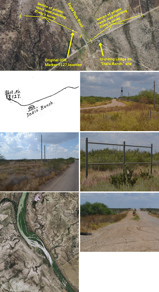
Second row (l to r): Zively's sketch of survey post #127; ranch road and water tower at Indio Ranch site.
Third row (l to r): Ranch road preserving Zively's route west of Eagle Pass Road; ladder over ranch fence near the Rio Grande.
Bottom row (l to r): Satellite view of Paso de Francia on the Rio Grande; Border Patrol drag trail beside Eagle Pass Road.
Ranching Country
The Old San Antonio Road enters Maverick County from Dimmit County north of San Pedro Creek. Zively placed the survey post for OSR Marker #125 on the east bank of San Ambrosia Creek, which runs north-to-south approximately parallel to and a half-mile west of the Dimmit-Maverick County line. The road crossed San Ambrosia Creek and passed through some hills. It then turned northwest and followed the south bank of one of San Ambrosia's branches for over 3 miles. Zively placed the survey post for OSR Marker #126 on this section, only 1.7 miles from the previous post.
About five miles inside Maverick County, the road left the creek and turned southwest. The land from approximately from this location westward to the Rio Grande was originally granted to Antonio Rivas in 1765. In 1850, Rivas' heirs sold the northern half of their vast 123,000-acre estate to General William L. Cazneau, the founder of the city of Eagle Pass.
Cazneau established a ranch on the Rivas Grant, but in 1853, he left the United States to serve out a diplomatic appointment in the Dominican Republic. By 1880, Cazneau's ranch was known as Indio Ranch. It had a post office from 1880 to 1884. The year the post office was closed, Indio Ranch had 30 residents and a general store.
In the early 1930s, a road was constructed from Eagle Pass to Laredo, through the middle of the old Rivas grant. Maverick County also began constructing a series of irrigation canals south of Eagle Pass. The community of Indio Ranch then migrated northward. The town of El Indio was established at its present site, 18 miles southeast of Eagle Pass, by 1938, the year that the irrigation canals were extended to that area. El Indio received a post office in 1939.
The road from Eagle Pass to El Indio was designated as Texas Farm-to-Market Road 1021 in 1948. The state designation now extends 14 miles south of El Indio. The rest of the Maverick County portion of the road to Laredo is an unpaved county road called Eagle Pass Road.
Zively's route of the Old San Antonio Road intersects Eagle Pass Road approximately 16 miles south of El Indio, or about 2 miles south of where it changes from state to county maintenance. This intersection is the only place in Maverick County where Zively's route is on public property. The site Zively indicated as Indio Ranch is about 900 feet east of the intersection. A hunting lodge and an old water tower now mark this site. The historic route is preserved by a private ranch road that passes north of the hunting lodge. Just past the lodge, the Kings Highway turns northwest. Another ranch road on the west side of Eagle Ranch Road preserves the historic road as it heads toward the Rio Grande (see the satellite photo at upper right). Zively placed the survey post for OSR Marker #127 on this road, about 500 feet west of Eagle Pass Road.
Hundreds of thousands of people cross the border illegally from Mexico into Texas every year. Maverick County sees more than its share. The strip of ranchland between Eagle Pass Road/FM 1021 and the Rio Grande is between 2 to 4 miles wide in most places. The first barrier most illegal immigrants who come through here face, therefore, is a ranch fence on Eagle Pass Road. Some ranchers, tired of seeing their fences get cut and having their cattle and wild game escape, have installed ladders at frequent intervals on the fence line. Once over the fence, the immigrants scurry across Eagle Pass Road, where they are highly exposed, and vanish back into the brush in the ranches on the east side of the road. While they are crossing Eagle Pass Road, however, they must cross a wide dirt path, parallel to the highway, which the U.S. Border Patrol keeps smooth by dragging tractor tires behind their trucks. The Border Patrol monitors these paths for footprints or other signs of disturbance to help them locate recent crossing activity.
The oil business has not taken over southern Maverick County to the same degree as some of its neighboring counties. The oil is there, but extracting it takes large volumes of water, and the costs of getting the water out to this area are too high to make oil production economically feasible.
About halfway between Eagle Pass Road and the Rio Grande, Zively's route merges with another major route of El Camino Real known as the Upper Road or the Upper Presidio Road. It then reaches the location of Zively's final survey post, #128, at the Rio Grande ford known as Paso de Francia, or "France Pass." Spaniards began exploring Maverick County in the 1660s, but the first documented Spanish crossing at Paso de Francia was that of Alsono de León in 1688. De León's discovery the following year of the French colony founded by Robert La Salle may well be the origin of the name, "France Pass." The ford is at a location where the river is wide, but shallow, and dotted with small islets. Despite its popularity and obvious utility as a safe place to cross the Rio Grande, it was not uncommon for large expeditions to take an entire day or longer to cross the river here.
Page last updated: September 21, 2015
- Zively, V.N. - "Field Notes and Detail Map of the Kings Highway", 1916
- Carson, David - field notes observed and recorded in 2015