
Rediscovering and Preserving El Camino Real
Rediscovering and Preserving El Camino Real
- The Origins and History of El Camino Real
- The DAR Old San Antonio Road Project, 1915-1918
- Norvell's Idea
- Zively's Survey
- The Granite Markers
- Dedication and Recognition
- Paving the Old San Antonio Road, 1917-1951
- The Texas Highway Department
- State Highway OSR
- A New Paradigm: "Los Caminos Reales", 1991-present
- The Tricentennial Report
- DAR Rededication Project
- The National Historic Trail
- TexasCounties.net Project
The Origins and History of El Camino Real
El Camino Real de los Tejas, or "The royal road of the Tejas," was a major overland route through Texas that was originally established in the late 1600s to connect the Spanish missions among the Hasinai ("Tejas") and other tribes in east Texas to the government centers in Mexico. This system of roads received widespread usage in the 1700s and early 1800s, and shaped Texas history during that period in numerous ways. In the 1800s, the various routes of the camino real declined in importance. Some are still in use, but primarily serve local traffic, while others have all but disappeared. For more information about the origins or history of El Camino Real de los Tejas, please see our previous articles in this topic.

The DAR Old San Antonio Road Project, 1911-1918
Norvell's Idea
The earliest effort to preserve and commemorate El Camino Real de los Tejas was conceived in 1911. Claudia W. Norvell (also known as Mrs. Lipscomb Norvell), a member of the Daughters of American Revolution (DAR) who lived in Beaumont, was attending the group's annual convention in Washington, D.C., where she heard a delegate from Missouri declare that the Santa Fe Trail, which began in 1791, was the oldest trail in the United States. Norvell, knowing that El Camino Real de los Tejas was a hundred years older, thought it would be good to recognize that fact. At their November 1911 meeting in Galveston, the DAR's Texas chapter developed a plan to commemorate the road and selected Norvell to oversee it.
The DAR's plan was to mark the route of the El Camino Real with granite markers placed at five-mile intervals. The DAR worked with the Texas Legislature to hire a railroad surveyor, V.N. Zively, to place oak survey posts indicating where the granite markers were to be placed. The DAR contributed $13,000 for the project, and the legislature appropriated $5,000. The railroads agreed to transport the granite markers for half of the regular rate.
Zively's Survey
The surveying portion of the project commenced in 1915. Zively started at the Sabine River, as the portion of the camino real in Louisiana was not included in this project. From there, he worked westward and southward to the Rio Grande, placing 124 oak survey posts approximately five miles apart. All of them were placed on the right hand side of the road as one travels from Louisiana to Mexico, which is, generally speaking, the north side.
Zively was by no means rigid about the five-mile specification. Many posts were placed closer; if he had a chance to put a post at a well-known landmark or county line, he did, even if it had been only two miles since his last post. A few were placed farther apart, "for instance where the measured five miles would have necessitated the placing of a post in the midst of a cultivated field, I either stopped short of the instructed distance or went a few hundred feet beyond, in order to place the marker where it would be least likely to be molested." Then again, he showed twelve of the posts as being placed exactly 26,400 feet from each other, and another dozen or so were within a hundred feet of that. In all, Zively placed 124 oak survey posts along 541.9 miles of Texas, at an average distance of 4.4 miles apart.
As explained in our article, "History of El Camino Real de los Tejas", the royal road consisted of two main routes from the Sabine River to San Antonio and two or three main routes from San Antonio to the Rio Grande. For the first section, Zively followed the southern route, or Camino Arriba. Though the newer of the two main routes, the Camino Arriba had been used as a legal boundary in land grants for almost a hundred years, and much of it was still in use as a road in Zively's day. Zively wrote that from the Sabine River to the Colorado River at Bastrop, he was able to find the route from examining land surveys from the 1800s, "so that the relocation of the road in that part of the State was only a question of time and labor." West of the Colorado River, apparently the land surveys either could not be obtained or provided no assistance, for "there was little to guide me except tradition and the remaining evidence of the road to be found on the ground."

For the section from San Antonio to the Rio Grande, Zively followed the Lower Presidio Road. This route, though old, only received widespread use for a few decades in the mid-to-late-1700s, when Apache raids along the Upper Presidio Road made that route too dangerous for most folks to travel. Zively used this route because his only guide was the diary of a Spanish friar named Morfi, who documented his journey along the road in December 1778. Zively wrote that Morfi's diary was invaluable, calling its author "the most accurate artist in words of a country traversed that I have ever met - in books." Nevertheless, after Zively placed survey post #102 in La Salle County, he got off track and followed the Laredo Road by mistake. After he realized his error, he went to the Rio Grande and began working his way northeast up the Lower Presidio Road to post 102. In the process, he overestimated the distance he had traveled and left a skip in his numbering system, so that the post following #102 was numbered 108. Another anomaly in La Salle County is that a post placed between #100 and #101 was not numbered, but given the letter designation, "Post A."
In addition to placing his survey posts, Zively made sketches of the route he had marked. The sketches, which were to the scale of 3,000 feet per inch, showed the exact course of the road as he determined it, annotated with every river, creek, town, county line, and railroad that it crossed, plus any other pertinent landmarks, such as prominent buildings or streets. Many of these landmarks are gone now or are no longer recognizable by the names in Zively's notes, while others are quite easy to make out to this day. Zively also provided a table of compass headings and distances describing the path from each post to the next in detail. It was common for him to make twenty, thirty, or even more data points for each five-mile segment. It should be noted however, that while Zively's assurance that he "measured every meander, every deflection of the old road as carefully as I ever measured a line for a proposed Railroad" appears to be sound, this commitment to accuracy pertained only to the road itself, not to the identifying landmarks. In other words, where Zively shows the road crossing a county line, his sketch of the road is probably accurate, but his sketch of the county line could be only a rough estimate.
In 1916, Zively presented his sketches and notes, plus a preface that this article has been quoting from, in a volume entitled Field Notes and Detail Map of the Kings Highway From Pendleton's Ferry on the Sabine River, to Paso de Francia on the Rio Grande. The volume also includes a three-page typewritten English translation of a portion of Friar Morfi's diary from 1778. It is unclear whether Zively used this translation or whether it was inserted into the volume by someone else. A specimen of the volume is kept in the Texas State Library at Austin. Unfortunately, it appears to be a poor-quality, low-resolution photocopy. The road sketches themselves are in satisfactory condition, but many of Zively's notes and detailed measurements are illegible.
Despite the problems with Zively's notebook, it still contains an incredible wealth of information about "The Kings Highway," as he preferred to call it. The plan to identify and preserve the road as conceived by Norvell and the DAR and executed by Zively came at the right time - when the old records were still available, when the original road was still visible on the ground, and when the landmarks in Morfi's diary still existed. Researchers attempting to find the road today based only on the information Zively had available would face an impossible task. Thanks to Zively's notes, however, present and future historians and researchers have a permanent record of this all-important 18th and 19th-century highway.
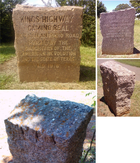
Top right: Marker with a sloping top.
Middle right: Typical rough, irregular top, sides and back.
Bottom left: Drill holes on back and divot on top front center.
The Granite Markers
Zively's 1915 survey of The Kings Highway was the first phase of the DAR's preservation project. The second phase was the setting of large pink granite markers at each of Zively's survey posts. The contract to manufacture and install 123 markers for $4,300 was awarded to A. L. Gooch, who was mentioned in the 1910 edition of the Granite Cutters' Journal as the owner of a granite plant in Houston.1 The granite blocks, weighing about a ton each, were transported to their destinations by the railroads. Gooch planted the first 118 of them, but reported that "owing to the condition of the country west of Cattarina, it was utterly impossible to set the remaining 5 markers." The last five markers on the road, therefore, were set by local craftsmen.
Most of the markers still exist today, so obtaining a good physical description of them is a simple matter of observation. The markers have many shared physical characteristics, but they also have many variations, so that no two are exactly alike. First, they vary significantly in size from 21 to 39 inches wide and from 10 to 22 inches deep. Their heights are difficult to determine, as all of the observable specimens are now set at least a few inches in concrete, dirt, or some other material to keep them in place. Some of the ones that have never been moved are now sunk quite deep into the earth. Overall, the markers stand anywhere from 22 to 54 inches above ground level, with heights of 28 to 34 inches being the most common.
Besides their dimensions, the markers vary in that while most of their corners are right angles, some of them have sloped surfaces, such as a top that slopes down from right to left or from front to back. Occasionally, one side will be thinner than the other. These differences in shape give these cold, hard blocks of stone a charming individuality that is a relic of pre-mass-production times.
All of the markers are polished smooth only on the front; the top, back, and sides are rough and irregular. On the front, they all - with one exception - bear this identical inscription:
CAMINO REAL
OLD SAN ANTONIO ROAD
MARKED BY THE
DAUGHTERS OF THE
AMERICAN REVOLUTION
AND THE STATE OF TEXAS
A.D. 1918
The one marker with a different inscription is the first one, placed at the Sabine River. It has the same inscription, with one additional line above it: TEXAS-LOUISIANA BOUNDARY.
As with Zively's oak survey posts, all of the markers were originally placed on the westbound side of the road - typically the north side - so that they were on the right-hand side to a person traveling the road from Louisiana to Mexico. They were also oriented so that the engraved side faced the road. More often than not, this meant the marker faced south or southeast. Many of the markers have been moved or reoriented since 1918, however, so there are now some exceptions to these rules.
Upon close inspection of the markers, one may notice that they have certain surface features in common. First, nearly every marker has several man-made grooves along the edges. Sometimes they are vertical, and sometimes they are horizontal. Sometimes these grooves are deep enough to make cylindrical holes, as in the photo above. This proves that they were drilled, and are most likely the means by which the individual blocks of granite were separated from each other.
The other typical surface feature on the granite markers is a circular depression or divot about an inch and a half in diameter. Though not present on every marker, this divot exists on most of them, and when it is there, it is usually in the same place - on the top, toward the front, near the center (see photo). This could be either a result of the markers' manufacturing method, or something that was imparted on them during their original transportation or installation.
As subsequent sections in this article will explain, the 123 pink granite markers placed along the royal road in 1918 have become a piece of history in their own right. Substantial attention has been given to finding and cataloging them. Some of the markers have been given landscaping treatments and their own driveways and signage on the road, while others are alone in tall weeds, undisturbed for a century. Still others have been lost.
Dedication and Recognition
After the markers were placed and the project was completed, a dedication ceremony was held at the site of Marker #84 in San Pedro Park in San Antonio on March 2, 1918. Claudia Norvell, state regent of the Texas Society Daughters of the American Revolution who conceived and directed the project, formally presented the camino real to the state of Texas.
A DAR record of the dedication ceremony published in 1929 reads, in part, "The presentation of the surveyed, marked and inspected trail Camino Real, King's Highway, or the Old San Antonio Road, was made to the State of Texas on that afternoon by the Daughters of the American Revolution." Note that the road is called by three different names, just like the engraving on the markers. This is consistent with all past and present DAR literature about the road; it is hard to find any reference to the road by Norvell or the DAR that does not use all three names, except occasionally with a variation such as "Royal Highway."
The name "Old San Antonio Road" had, up to this time, referred only to the route previously called the Camino Arriba, which went between San Antonio and Natchitoches, Louisiana. The DAR, however, used "Old San Antonio Road" synonymously with "Camino Real" and "Kings Highway" to refer to the entire road, all the way to the Rio Grande.
On the subject of routes, one finds no mention in the writings and notes of Norvell, Zively, and the DAR of the other main routes of El Camino Real de los Tejas: the Camino de los Tejas, the Upper Presidio Road, and the Camino Pita. It is unclear whether those who undertook the project were unaware of the existence of these other routes, or they simply chose to focus on two - the Camino Arriba and Lower Presidio Road - to the exclusion of the others.
A law passed by the Texas legislature in 1929 entitled, "Providing for Preservation of Old San Antonio Road", required that the recently-established state highway commission preserve and maintain the route surveyed by Zively in 1915. The writers of the law apparently believed one name was sufficient. Section 1 stated, "The Road surveyed by V.N. Zively in 1915, commonly known as the Old San Antonio Road or 'King's Highway' or 'Camino Real' shall forever be known as the Old San Antonio Road." The rest of the law, which mandated that Zively's route be preserved and maintained, was never fully enacted, but significant and lasting steps toward it were taken over the next few decades.

Paving the Old San Antonio Road, 1929-1951
The Texas Highway Department
The Daughters of the American Revolution's project to survey and mark the camino real came at the same time that the nation's approach to roads was being revolutionized. When Zively made his survey in 1915, there were no paved roads in Texas. Automobiles, still somewhat new, had great difficulty navigating the dirty, muddy trails of rural America. The U.S. government, in the interest of promoting reliable mail delivery and preparing for possible war, passed the Federal Aid Road Act in 1916. This law, the first federal highway funding law, offered matching funds for paved highway construction for states that had a highway agency. In response, Texas created the Texas Highway Department in 1917.
The new department presented a plan to build 26 highways across the state. On the map drawn by State Engineer George A Duram, Highway 21, the Gonzales-San Augustine highway, followed the Camino Arriba from the Sabine River to Bastrop. Highway 3A, a branch of the "Southern National" highway from Orange to Del Rio, continued the Camino Arriba to San Marcos. Highway 2, the "Meridian" Highway from Burkburnett to Laredo, continued the Camino Arriba to San Antonio and also took in part of the Camino de los Tejas from San Marcos to Austin, as well as part of the Upper Presidio Road west of San Antonio.
Numerous problems hindered the construction of the proposed highways. At first, the new state department's only role was to inspect and approve the counties' uncoordinated, small-scale plans. So little got done that the state was in danger of losing its federal matching funds. In 1923, the legislature raised fees and taxes and transferred construction and maintenance to the state, which, at that time, owned not one single truck, tractor, or any other piece of road construction equipment. Then, just as the state got ramped up to build roads under the celebrated state engineer Gibb Gilchrist, Governor Miriam "Ma" Ferguson took office and turned the state highway department into a mechanism to award lucrative state contracts to her political supporters, where getting a usable product in return was not a priority. As of 1927, only about 1,000 miles of the 16,000 miles of state highways in Texas had been paved.
On January 1, 1927, Dan Moody took office as governor of Texas. Moody wasted no time in hiring Ross Sterling as head of the Highway Commission. He also persuaded Gibb Gilchrist to return as state engineer. When federal matching funds were restored, the department resumed highway construction in earnest in 1928 and finally began making serious headway on constructing the 26 state highways proposed in 1917.

State Highway OSR
On March 19, 1929, Governor Moody signed Senate Bill 570, "Providing for Preservation of Old San Antonio Road". The new law recognized the Zively/DAR route of El Camino Real as "The Old San Antonio Road" and required the Highway Commission to preserve and maintain it. By that time, some of the Old San Antonio Road had already been built as State Highways 2, 3, and 21, but an unbuilt section between San Marcos and Midway was given the special designation of State Highway OSR.
According to a map produced in 1936 by the State Highway Commission for the Texas Centennial, State Highway 21 had been completed from the Sabine River to around Bryan, but it still had a gravel surface in most of Sabine, San Augustine, and Nacogdoches Counties, and about half of Houston County. It also bypassed Zively's route in numerous places. State Highway OSR was paved all the way from Midway in Madison County to Benchley in Brazos County. The OSR between Benchley and San Marcos in Hays County was still largely dirt or non-existent. State Highway 2/US Highway 81, the forerunner to Interstate Highway 35, was paved all the way from the Rio Grande to the Red River, including the portion of the Old San Antonio Road from San Marcos to New Braunfels. The only paved sections of Zively's Old San Antonio Road below San Antonio was State Highway 66 to Pleasanton. To date, no state highway has been built to preserve the route from Atascosa County to the Rio Grande.
In 1942, the OSR State Highway was extended from Benchley to Highway 21 west of Bryan. The following year, the designation "OSR State Highway" was removed from every section of road west of that point; the name was changed to Highway 21. The final section of Zively's route to be added to Highway 21 was between Paige and Bastrop. It was completed in 1951. Highway 21 continues to San Marcos and terminates there. Zively's route skips around from one road to another from San Marcos to San Antonio.
No road west of San Marcos has ever been designated as OSR State Highway.
In summary, Zively's surveyed route is easy to follow - albeit with gaps - from the Sabine River to San Marcos. From San Marcos to northern Atascosa County, it takes some expertise to find the road, if it even exists. From Atascosa County to the Rio Grande, local and county roads preserve a few miles of the historic route here and there, but for the most part, it is lost. It seems, then, that the state legislature's 1929 order for the highway department to designate and preserve Zively's route in its entirety got off to a good start, but was never fulfilled the way the law intended.
A New Paradigm - "Los Caminos Reales", 1991-present
The Tricentennial Report
El Camino Real has never been forgotten by Texans, especially in the towns that grew around it, but in the mid-to-late 1900s, it received little attention from either the state of Texas or any state or national organizations. A 1962 proposal by retired state engineer Gibb Gilchrist, who later became President of Texas A&M University, to locate and review all of the DAR Markers did not gain any traction.
The late 1900s brought a renewed interest in the road. In 1989, the Texas legislature created the Old San Antonio Road Preservation Commission to study the road and suggest ways to preserve it, encourage tourism, and raise public awareness of the road for a year-long tricentennial celebration to be held in 1991.2 The Commission's first chairman was Texas history professor and author Archie P. McDonald.
The Old San Antonio Road Preservation Commission operated until 1993. Its main contribution to El Camino Real history was its comprehensive report published in 1991 entitled A Texas Legacy: The Old San Antonio Road and the Caminos Reales, a Tricentennial History, 1691-1991. Led by archeologist Joachim McGraw, the project team, which also included Texas historian Stephen L. Hardin, reported its finding that the route that V. N. Zively surveyed in 1915 was only one of several making up "los caminos reales" - the royal roads. This report changed both scholarly and popular thinking about the road from being one path to a network of interconnected paths. The report discussed the five main routes: the Camino de los Tejas, the Camino Arriba, the Camino Pita, the Lower Presidio Road, and the Upper Presidio Road. For a detailed explanation of these routes, please read our article, "The History of El Camino Real de los Tejas".
The state of Texas placed several informational displays along El Camino Real in 1991 to educate the public about the commission's findings. Some of these are found alongside one of the DAR granite markers, while others are standalone.
The DAR Marker Rededication Project
In 1994, the Texas Society of the Daughters of the American Revolution, which was founded in 1894, kicked off a centennial project to locate, document, photograph, and rededicate the granite markers placed by the society and the state of Texas along the Old San Antonio Road in 1918. The chairman of the project was the Texas Society DAR state regent, Virginia Stegall. The DAR was assisted by the Texas Department of Transportation and various county officials. From 1995 to 2001, members of the society went out to carry out this project. Since several of the markers between San Antonio and the Rio Grande were on private property, private landowners who cooperated with the DAR were given a letter of thanks and an informational packet about the markers.
The Texas Society DAR compiled their data and photographs and published them on their project web site. At a minimum, every marker found was photographed. Directions using modern roads and landmarks were given for most of them, and geographic coordinates were given for some. In all, the DAR succeeded in finding and photographing 97 of the 123 markers.3 Nine of the markers were on private property and were photographed by, or with the permission of, the landowners.
Regrettably, dozens of the markers had been moved in the last 80 years. While some were moved out of necessity due to a widening of a road or, as in the case of Marker #1 in Sabine County, so as not to be submerged in the Toledo Bend Reservoir, others were moved - in several cases between five and ten miles - simply so that they would be more visible, such as by placing them along a public roadway or in a site with other historical markers and artifacts. No one recorded the original positions of the moved markers. Surely neither Mrs. Norvell nor Mr. Zively would approve of their work to locate and memorialize the Kings Highway being undone by people who were more interested in the markers than in the road they were intended to preserve!

The National Historic Trail
In 2004, Congress passed and President George W. Bush signed a bill proposed by Senator Kay Bailey Hutchison to designate El Camino Real de los Tejas as a National Historic Trail. In addition to the five main routes used to travel from the Rio Grande to the Sabine River via San Antonio, the national historic trial includes old Spanish roads in other parts of the state, including the Laredo Road from Laredo to San Antonio and the several roads that terminated in Goliad. It also includes the sections of the camino in Louisiana between the Sabine River and Natchitoches. In all, El Camino Real de los Tejas National Historic Trial encompasses 2,500 miles of old Spanish trails in Texas and Louisiana.
The National Historic Trail is administered by the U.S. National Park Service. The park service works with counties who are interested in commemorating the trail. The park service produces signs, which are then erected at designated locations by county personnel.
Milam County was the first county to participate in the El Camino Real National Historic Trail. On October 8, 2012 at Apache Pass in Rockdale, Senator Hutchison unveiled the first sign on the trail, and the first of 62 signs to be erected in Milam County.
According to the web site of the El Camino Real de los Tejas National Historic Trail Association as of July 2012, the next signs are planned for Victoria County.
TexasCounties.net Project
From 2013 to 2015, David Carson, the author of TexasCounties.net, conducted a project to document the Zively/DAR route of the Old San Antonio Road county-by-county and mile-by-mile. The purpose of the project was to retrace the complete road as much as possible, whether it is on a major highway, a city street, a one-lane dirt county road, or a mere clearing in the brush. Each town or historic site along the road was photographed and described, and particular attention was paid to locating, photographing, and describing the granite markers placed along the OSR in 1918. The results of this project were published on our page entitled A Tour of the Old San Antonio Road..
Page last updated: October 29, 2015
1The 1910 edition states that Gooch's plant was shut down, but he was expecting some new jobs in Houston and Austin. In the 1920 edition of the journal, he is listed as being from Austin.
2Domingo Terán's 1691 expedition is generally considered the "birth year" of the road.
3This does not include Marker #9 in San Augustine County, which is listed as found on the Texas DAR's project web site, but the accompanying photograph shows a featureless block of concrete with smooth sides and rounded corners.
- Texas Society DAR - Old San Antonio Road DAR Marker Information Site
- Zively, V.N. - "Field Notes and Detail Map of the Kings Highway", 1916
- Carson, David - field notes observed and recorded in 2013.
- Texas State Library and Archives Commission - From Pioneer Paths to Superhighways
- McGraw, Joachim and Hardin, Stephen L. - "Evolution of the Old San Antonio Road and the Caminos Reales", in A Texas Legacy: The Old San Antonio Road and the Caminos Reales, a Tricentennial History, 1691-1991
- Texas Department of Transportation