
Challenges in Route Interpretation
Challenges in Route Interpretation
Introduction
Alvar Nuñez Cabeza de Vaca was one of the first American explorers, and his La Relacíon is the earliest surviving historical record of Texas. His narrative is fascinating not only for its story of survival in an unknown land, but also for its vivid and detailed descriptions of the land he crossed and natives he met. His journey as second-in-command of the Narváez Expedition took him from the west coast of Florida around the Gulf coast to Texas, and across Texas and northern Mexico to the Pacific Ocean, covering most of this distance on foot. Readers of his story can easily identify the wooded swamps of Florida, the wetlands and bays of the Texas coast, the cactus and mesquite prairies of south Texas, and the mountains of northern Mexico. For as long as people have been reading his story, however, they have been trying to understand more specifically where it took place. Where on the long Florida peninsula did the expedition begin - The Everglades, Charlotte Harbor, Tampa Bay, or somewhere else? What was this "Island of Misfortune" where the castaways landed? What was their route from the Gulf of Mexico to the Gulf of California, and how much of it was in Texas? These questions have intrigued historians, researchers, and readers for nearly 500 years. While there is now more consensus about the correct answers than there once was, there are still many parts of Cabeza de Vaca's route that are open to interpretation and even argument.
One reason Cabeza de Vaca's route is difficult to interpret is that he was the first historian on it. Only one location - a river named Espíritu Santo - had been named before he got there, and while historians disagree on which river it was, they all agree that it was not the one Cabeza de Vaca thought it was. He found animals and plants no European had ever seen before, like the bison and the pecan, and called them by names he knew, like "cow" and "walnut." Follow-up expeditions to the lands he discovered were spotty and few, so most of the natives he met, who had never seen a European before him, never saw another one after him, either.
Despite these disadvantages, the texts authored or co-authored by Cabeza de Vaca - his own La Relacíon and the so-called "Joint Report" edited by Gonzalo de Oviedo - do contain a lot of information that we can use: distances, estimates of travel time, discussions of the topography and terrain, observations about the native flora and fauna, and so on. The challenge is in correctly interpreting each of the data points the texts give us. This article explains these challenges.

Order your copy of The Account of Cabeza de Vaca: A Literal Translation with Analysis and Commentary, translated by David Carson of TexasCounties.net, available in E-book and paperback formats.
Distance (Leagues)
The league - or "legua" in Spanish - was a unit of length in Spanish-speaking countries prior to the adoption of the metric system. It was used to measure distances that people today would measure in miles or kilometers. The Narváez Expedition chronicles use leagues to describe distances traveled as well as the dimensions of geographical bodies, such as islands and bays. They sometimes use "jornadas," which means "travel days" - i.e. a destination three jornadas away would take three days of travel to reach. The only other units of length in the texts are "brazas," or fathoms, in describing the depth of water or the length of some objects, and a few shorter units such as palms and cubits. These other units are readily understandable. Understanding the league is the key to cracking Cabeza de Vaca's distance code.
The Spanish league was meant to represent the distance that a person could walk in an hour. In the 20th century, before the metric system was adopted, a league was defined as 4,000 paces (pasos), which equaled 6,666.67 varas. In modern units, this converts to 5.5728 kilometers, or 3.46 miles. The league had many definitions over the many centuries and countries where it was used, however. Even some provinces of Spain had different definitions for it than others. One web site explaining the league presents 29 different standards for it that were used in various places and times in history. These definitions resulted in a league as long as 4.64 miles and as short as 2.5 miles. Since Cabeza de Vaca was from Spain and wrote La Relación from Spain for a Spanish king to read, it is logical to conclude that his league was the one used in Spain, which was either the same as the 3.46-mile league of the 20th century, or reasonably close to it.
Students of Texas or American history may be more familiar with a league that equals 2.6 miles. This is a standard cited and used by many authorities. One must understand, however, that the 2.6-mile league was the "statute league," or "legua legal," which was different from the longer "common league," or "legua común." The statute league of 3,000 paces or 5,000 varas was the legal standard for measuring the dimensions of parcels of land. Landowners or parties to a dispute would measure off the tract in question with a cord of known length, much as we might measure a field with a nylon tape today. The common league of 4,000 paces was the standard for measuring the travel distance from one destination to another.
The best way to interpret Cabeza de Vaca's league may be to look at some examples from the texts. While most of the distances reported in the texts are estimates that Cabeza de Vaca and his companions made in the field, a few had presumably been measured and established fairly well by the time he wrote. One of those pertains to the distance from Trinidad, Cuba, to Cienfuegos:
"He put me in charge of the ships, and of the people, to go with them to spend the winter at the port of Xagua [Cienfuegos], which is twelve leagues from there..."1
The distance from Trinidad to Cienfuegos is 39 miles as the crow flies. Going by sea from one port to the other is 40 miles. There is no reason Cabeza de Vaca would have had to estimate this distance as 12 leagues; presumably, either someone told him, or it was a well-known fact. Using the 3.46-mile common league, this converts to 41.52 miles. Twelve leagues is exactly right. A measurement of 11½ leagues would be too short, and 12½ leagues would be too long.
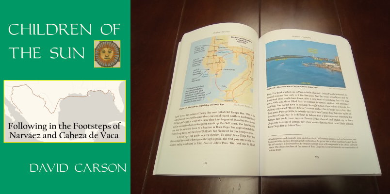
Another confirmation of the 3.46-mile league comes in Chapter 38 of La Relación, where Cabeza de Vaca describes the port to which Narváez's pilot, Miruelo, had meant to direct the fleet:
This port that we speak of is the best in the world, and enters the land seven or eight leagues, is six fathoms at the entrance, and near the land it is five ... It is a hundred leagues from Havana, which is a village of Christians in Cuba, and is at north-south with this village... They come and go from one part to another in four days, because the ships come and go on the quarter."2
The above description not only positively identifies the location as Tampa Bay, Florida, but it also confirms the length of Cabeza de Vaca's league. Once again, these were not his field estimates reported from memory, but measurements that were known and used by the people of his time. The distance from the port of Tampa to the port of Havana, going as straight a route as possible, is 340 miles, or 98.26 common leagues. The city of Tampa is at 82.46°W longitude; the city of Havana is at 82.35°W - they are "north-south" with each other. The distance from the from the easternmost point of the bay, near the Alafia River, in a straight east-west line to the Gulf shore is 27.6 miles, or 8.0 leagues. There are many other ways to interpret how far the bay "enters the land," as far as where to draw the line, but by this reasonable interpretation, Cabeza de Vaca's measurement of 7 to 8 leagues is right. No other body of water on the eastern coast of Florida comes as close to matching any one of these three measurements as Tampa Bay does, and no other interpretation of the league works as well as the 3.46-mile common league.
Although we can now feel confident that we know the length of Cabeza de Vaca's league, we must still exercise care when interpreting his route. The examples we just used were known measurements, but most of the other distances given in the texts are only rough estimates of distances that Cabeza de Vaca and his companions made on the go, carried around in their heads for up to nine years, and had to recall from memory. We know that quite a few of those are very wrong. For example, at the end of his journey, Cabeza de Vaca estimated that he and his companions traveled 2,000 leagues. No matter what standard one uses for the league, that is way too high. The route was some 2,500 miles - about 722 leagues. And using a smaller league does not help; even using the 2.6-mile statute league, for a total of 962 leagues, he was still way off. The problem is not with our interpretation of the league; it is with his estimate. As we study the texts, we find that Cabeza de Vaca usually overestimates the length of distances he traveled. Furthermore, the magnitude of his error tends to correspond with the distance. For shorter distances, such as ten leagues or less, his accuracy is better. Even with short distances, however, we must bear in mind that he is remembering them several years after the fact. The best way to interpret distances in the texts is to always consider them as estimates or guesses and to subordinate them to other information that would have been easier to remember and harder to get wrong, such as whether an area was hilly or level and whether it was among wetlands or dry plains.
Climate, Flora, and Fauna
Readers of Cabeza de Vaca, especially those who have spent much time on the Gulf coast, will notice that the climate seems wrong. We read of European explorers who thought it too cold to travel in mid-November and who froze to death in an area where the average low temperature in January today is 45°F. Readers may wonder whether this story is set in Texas or Newfoundland.
The truth is, this really is what Texas was like at that time. Scientists have determined that for much of the 16th through 19th centuries, and perhaps earlier, much of the world, including Europe and North America, experienced much cooler climates than they had over the previous millennia or have had since. The term "little ice age" entered the scientific literature in 1939. The little ice age is evident in documents of Texas history written in the 1700s and early 1800s, but it does not seem to be as pronounced in them as it is the Narváez Expedition chronicles.
Considering that the climate was known to be different in Texas in the 1500s than it is today, we must exercise care in interpreting Cabeza de Vaca's route based on his descriptions of the flora and fauna he saw. The distribution and habitats of the prickly pear cactus, the bison, and other plants and wildlife the texts mention so often may have been different in the 16th century than they were in the 19th century or are now. That is not to say that they must have been different; it only means that we must not rule out a route interpretation or a data point that otherwise fits because the temperature or wildlife habitat seems off.
Order your copy of Children of the Sun: Following in the Footsteps of Narváez and Cabeza de Vaca, by David Carson of TexasCounties.net, available in E-book and paperback formats.
Topography
Cabeza de Vaca and his companions left a lot of notes about the physical appearance of the lands they traveled through. For example, they noted an abundance of trees and brush in Florida and a scarcity of wood on the mainland across from the Island of Misfortune. They observed mountains in the latter part of their journey, while complaining of the lack of stones to use for boat anchors along the Gulf coast. They noted several places where they had to cross large rivers or bays. These observations not only add color to the narrative, but they also provide important clues about where it took place.
The good thing about using topographic details as reference points is that they are mostly stable. Mountains do not move - at least, not in 500 years. Neither do ore and mineral deposits. The fringes of woodlands and forests might change somewhat because of the difference in temperature noted in the previous section, but still, entire forests do not appear and disappear overnight.
The main caveat about interpreting the topographical clues in the text concerns rivers and the coastline. Rivers move. Channels and inlets open and close, and islands appear and disappear. Take the Colorado River, for example: as recently as 1900, it emptied into Matagorda Bay. Today, however, it crosses a land bridge, cuts through the Matagorda Peninsula, and has a mouth on the Gulf of Mexico. The mouth of the Brazos River is also now three miles south of where it used to be. The change to the Brazos was man-made, but the change to the Colorado was partly man-made and partly natural. The construction of the Gulf Intracoastal Waterway in the 20th century cut off some creeks, such as Oyster Creek and Caney Creek, from direct contact with the coast. Numerous other small but significant changes have been made to the Texas coast in the last 150 years that we know of, not to mention the 350 years before that, for which we have few records. This does not mean that Cabeza de Vaca route interpreters get to work with a blank slate and put rivers, bays, islands, and peninsulas anywhere they want them, but it does mean that route interpreters need to put extra work into confirming that their assertions about the Texas coastline are reasonable in light of how much it is known to have changed.
The Natives
Some of the most interesting material in La Relación and the Joint Report concerns the native peoples that Cabeza de Vaca and his comrades encountered. Some of these tribes are remembered for their generosity and kindness to the castaways, while others are remembered for their harshness and cruelty. The texts describe these peoples' diet, seasonal migrations, cultural practices regarding marriage and death, and much more. The challenge in studying the natives in the Narváez Expedition chronicles is that it was nearly 200 years before most of them were visited again by European explorers. By that time, they had no recollection of Cabeza de Vaca or his comrades, and the names he recorded for the tribes - Capoques, Han, Mariames, Iguaces, etc. - had disappeared. Some of the clans Cabeza de Vaca lived with may well have died out or been eliminated by tribal warfare.
Fortunately, the details the texts give about tribes' customs and habitats leave many clues about where they lived. By spending some time analyzing all of the information the texts give about these tribes, we can reconstruct a substantial amount of the Narváez Expedition survivors' route through Texas. For such an analysis, see our article, "Interpreting the Territories of the Coastal Natives Described by Cabeza de Vaca".
Conclusion
As this article shows, tracing the Narvaez Expedition's route across North America requires a thorough analysis of the information given in the texts. In the past, some route interpreters have taken a far too simplistic approach, such as relying primarily on the distance measurements given in the texts, and even then not using the right standard for the Spanish league. Some interpreters have focused heavily on geographic features, such the locations of rivers, islands, and peninsulas, without taking into account how these features have changed since the 1500s. Fortunately, some diligent historians and researchers, such as Harbert Davenport, Joseph K. Wells, and Alex D. Krieger, have taken a more thorough approach. Because of their work, researchers studying the route of Cabeza de Vaca and his companions now have a sound foundation to build from. The basic elements of the route - starting at Galveston Bay, moving down to Matagorda Bay, and crossing the Rio Grande in south Texas - have now been established beyond any reasonable doubt. It is our hope that the articles in this topic will refine Cabeza de Vaca's route even further, establishing with even more certainty which Texas counties he and his comrades visited, and, if possible, on which specific dates and at which locations.
To continue reading our analysis of Cabeza de Vaca's route through Texas, please see our articles, "Identifying the Isla de Malhado" and "Identifying the Inlet of Espíritu Santo".
By David Carson
Page last updated: September 13, 2017