
The Old San Antonio Road in Cherokee County
The Old San Antonio Road in Cherokee County
- Map of the Old San Antonio Road in Cherokee County
- Route Details
- SH 21 / Linwwood
- Dill Grant / CR 2610
- SH 21 / Alto
- The Caddo Mounds to the Neches River
The Old San Antonio Road passes through the southern end of Cherokee County. It enters at the Angelina River, passes through Alto, and exits at the Neches River. Most of this country is cropland, cattle ranches, chicken farms, and timber farms.
State Highway 21 follows the OSR either exactly or very closely throughout much of the county, but, as always, there are exceptions. County Road 2610 on the east side, and County Roads 2907 and 2916 on the west side take in parts of the Kings Highway.
Map of the Old San Antonio Road in Cherokee County
[-]Collapse Map [+]Expand Map
Route Details
- State Highway 21 from the Nacogdoches County line for 3.0 miles to CR 2610. Highway 21 has an inexact conformance to the OSR. It has two undivided lanes, with no shoulder.
- County Road 2610 for its full length of 1.7 miles. This road conforms exactly to the OSR except at each end, where the intersections with SH 21 have been reworked. This road has one wide paved lane.
- SH 21 from CR 2610 for 6.6 miles, passing through Alto, to CR 2905 on the west side of Alto. Highway 21 has two undivided lanes with no shoulder. Its conformance to the OSR is very high to exact.
- SH 21 from CR 2905 for 1.6 miles to CR 2907, loose conformance. Highway 21 has two undivided lanes with no shoulder.
- CR 2907 from where it turns southeast sharply at the Caddo Mounds, for 0.9 miles to CR 2916. Parts of CR 2907 are on the OSR, while other parts are not. This is a paved one-lane road.
- CR 2916 from CR 2907 for 0.8 miles until it turns to the northwest near the Neches River, exact conformance. This is a paved one-lane road.
- Private dirt road or route lost from CR 2916 for 0.3 miles to the Houston County line.
SH 21 / Linwood
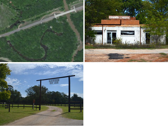
Bottom: Entrance to Linwood Crossing.
Highway 21 follows the Old San Antonio Road closely, but not exactly, west of the Nacogdoches County line.
Cherokee County was created from Nacogdoches County in 1846, with the Angelina River used as the boundary. The river has flooded numerous times since then, moving it substantially to the east. The county line, however, remains fixed. Consequently, the Cherokee-Nacogdoches county line at State Highway 21 is now 0.3 miles west of the river. Missing OSR Marker #19, which was placed on the west bank of the river, was probably washed away in a flood long ago.
The west side of the Angelina River crossing was originally settled by Joseph and Delilah Durst in the early 1830s. Durst's brother, John, constructed the first bridge across the river in 1832. That year, Col. José de las Piedras was driven from his position in Nacogdoches by a Texan militia in the Battle of Nacogdoches. Piedras, on his retreat to San Antonio, stopped at Durst's house on the Angelina River. There, his own men turned against him, and he was forced to surrender. The withdrawal of Piedras' forces marked the last presence of Mexican soldiers east of the Trinity River.
The Durst family founded the town of Linwood after the Texas Revolution at the intersection of the Old San Antonio Road and present-day FM 241. Linwood prospered for about fifty years, but it then folded after a railroad was constructed in neighboring Alto in the 1880s. Some homes and abandoned business property still occupy the former area of Linwood. A state historical marker is at the entrance to Linwood Crossing.
Dill Grant / CR 2610
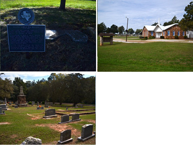
Bottom: Old Palestine Baptist Church cemetery on County Road 2610.
County Road 2610 between the Angelina River and Alto preserves the exact route of the Old San Antonio Road for 1.7 miles.
The land north of the Old San Antonio Road and west of the Angelina River was granted to James Dill in 1802. In 1804, Dill's wife, Helena, gave birth in Nacogdoches to a daughter, also named Helena, who is believed to be the first Anglo child born in Texas.1 Mrs. Dill, who was widowed in 1825, gained the title to her husband's land grant and moved there in 1828. Her grave and historical marker are on Highway 21, north of CR 2610.
The younger Helena married Henry Berryman. They built the Forest Hill Plantation in 1847. After her husband's death, Helena Berryman donated a tract of land to the Old Palestine Baptist Church and cemetery. The church, which V. N. Zivley noted on his 1915 survey, has existed on the same site since 1854. It is one of the few man-made landmarks on Zively's survey of the Old San Antonio Road that still exists today. The cemetery has existed since at least 1861.
Helena Berryman's historical marker is on Farm Road 241, several miles north of Highway 21.
SH 21 / Alto
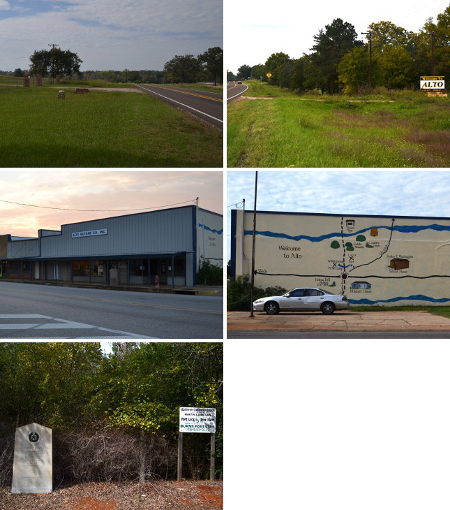
Middle (l to r): Site of OSR Marker #21; Historical mural of Alto.
Bottom: Lacy's Fort historical marker. The sign to the right states that the site is now a tree farm owned by Martin Lacy's granddaughter.
After CR 2610 re-enters Highway 21, the latter picks up the route of the Old San Antonio Road. OSR Marker #20 is near this junction. Highway 21 then follows the OSR exactly for 6.6 miles.
Alto is at the intersection of U.S. Highway 69 and State Highway 21, eleven miles south of the county seat of Rusk. It was founded in 1849 as Branchtown, then renamed Alto - Spanish for "high" - three years later. The new name was chosen because the town is situated on the highest point between the Angelina and Neches rivers.
Alto grew quickly before the Civil War. The construction of the Kansas and Gulf Short Line Railroad in the mid 1880s ensured its prosperity. When it was incorporated in 1909, it had a bank, schools and churches, and businesses including cotton gins and sawmills. Alto reached a peak population of 1,600 in 1929. The Great Depression took a toll, however, leaving only 1,053 residents in 1936. It has fluctuated between these two levels in the succeeding decades.
OSR Marker #21 stands prominently at the intersection of Highways 69 and 21 in front of the Alto Butane Company. This building also has a mural covering its east wall that points out some of the area's historic locations.
Southwest of Alto is the site of Lacy's Fort, which was built by Martin Lacy in 1838 as a defense from hostile natives. The blockhouse fort was used mainly as a rendezvous and staging point for various militia and army units in the late 1830s and early 1840s. By the mid-1840s, hostile natives had been eliminated from east Texas, and the fort was unnecessary. Most of the residents of Lacy's Fort moved to Alto a few years after the latter town's founding in 1849. The site was soon abandoned. Zively marked "Fort Lacy" on his 1915 survey, so apparently, part of it still existed then. Today, there is only a historical marker.
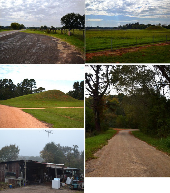
Middle (l to r): The Caddo burial mound; County Road 2916, with the dirt road showing where the Old San Antonio Road turned towards the Neches River.
Bottom: A house in Weeping Mary.
The Caddo Mounds to the Neches River
Southwest of Alto, near County Road 2905, Highway 21 diverges from the Old San Antonio Road. OSR Marker #22 is at the approximate location where the two routes separate.
One of the oldest and most unusual sites on the Old San Antonio Road is a little over a mile east of the Neches River. It is a level, grassy plain featuring three large mounds of earth. This was the home of a large prehistoric native community. Archeologists believe the site was inhabited from approximately 800 to 1300 A.D. by Caddo people. These natives cultivated corn and produced sophisticated pottery. Unlike the scattered, decentralized Caddo clans who inhabited east Texas in the 17th century when Spanish and French explorers arrived, their prehistoric ancestors congregated in large communities and had a ruling class consisting of a political and religious hierarchy. A large, flat mound in the center apparently served as a town square. The mound to the south is believed to have been a center of religious worship. The mound to the north was a burial site for members of the elite class. The Caddo Mounds State Historic Site preserves the three mounds, an excavation pit, and numerous artifacts.
Present-day Highway 21 passes through the Caddo site, but the Old San Antonio Road skirted around the north of it. Parts of County Roads 2907 and 2916 preserve the Old San Antonio Road. The small community of Weeping Mary is on CR 2907. This village, founded by freed slaves after the Civil War, consists today of a church, a few broken-down houses, and junk piles.
About a quarter mile from the Neches River, County Road 2916 turns northwest. Here, a private road follows the route of the Old San Antonio Road for a short distance, but most of the route in this area is now lost. Mission San Francisco de los Neches was probably located nearby. It was the third incarnation of the original east Texas mission founded in 1690. It was situated on the east bank of the Neches River from 1721 until 1730, when it was moved to San Antonio.
Page last updated: February 24, 2014
1Not "the first white child born in Texas," as it is sometimes expressed. Spaniards are white.
- Zively, V.N. - "Field Notes and Detail Map of the Kings Highway", 1916
- Carson, David - field notes observed and recorded in 2013
- Texas State Historical Association - The Handbook of Texas Online