
The Old San Antonio Road in North Caldwell County
The Old San Antonio Road in North Caldwell County
Also see The Old San Antonio Road Posts and Markers in North Caldwell CountyThe Old San Antonio Road passes through the northern tip of Caldwell County for about five miles. State Highway 21 preserves the route fairly well, except that this is one of the few places in the state where the modern highway has added some bends to what was originally an almost straight line. The road enters on the east side from Bastrop County. On the west side, it merges with the Caldwell-Hays County line. Highway 21 is referred to locally as Camino Real.
Map of the Old San Antonio Road in North Caldwell County
[-]Collapse Map [+]Expand Map
Route Details
- State Highway 21 from the Bastrop-Caldwell county line for 5.4 miles to a point where the highway merges with the Caldwell-Hays County line. SH 21 has an inexact conformance with Zively's route. It has two undivided lanes with narrow shoulders.
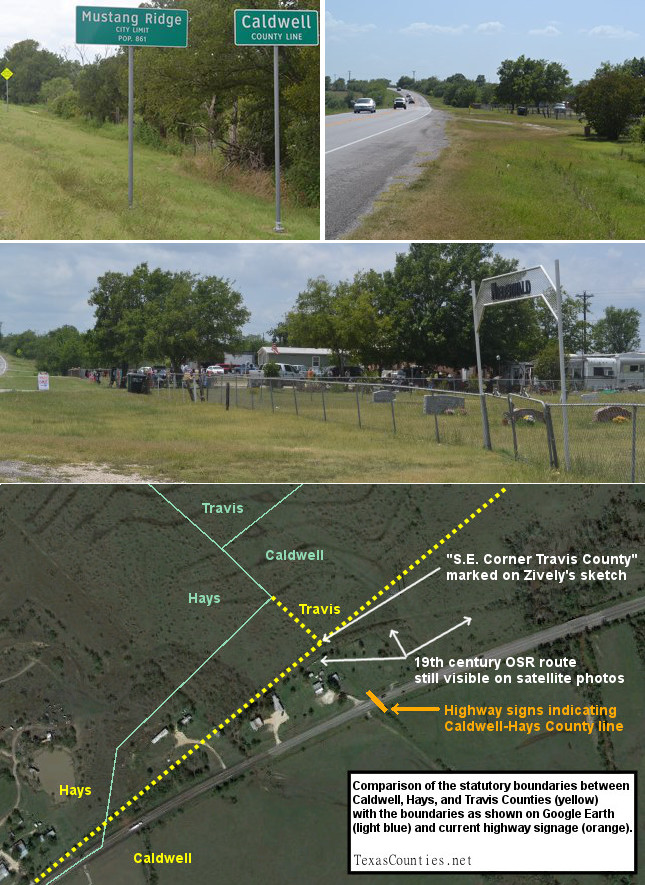
Middle: A yard sale.
Bottom: Annotated satellite photo showing county line confusion.
Highway 21
Zively's route crossed the Bastrop-Caldwell County line at or very close to where Highway 21 crosses it now. Zively placed the survey post for OSR Marker #69 at the county line, but the marker has not been found.
The small community of Mustang Ridge, which was incorporated in 1985, is mostly located in Travis County, but its city limits were drawn so as to include parts of Highway 21 in Caldwell County.
OSR Marker #70 is in front of the Niederwald Cemetery. The town of Niederwald is further west.
Marker #70 is near the point where Caldwell, Hays, and Travis Counties intersect. According to a statute passed by the Texas Legislature in 1848, the point where the Old San Antonio Road intersected a previous boundary between Bastrop and Gonzales Counties was established as the southeastern corner of Travis County and the northeastern corner of Hays County, with the road making up the Caldwell-Hays County line from that point all the way to the San Marcos River. Zively marked this reference point - the southeastern corner of Travis County - on his survey. Many modern electronic maps, such as Google Earth, show Caldwell-Hays-Travis County boundaries that are much more crooked and complicated than the simple, straight lines indicated in the 1848 statute. Even some printed maps make the boundaries out differently than they really are, but other maps, such as those produced by the Caldwell County Appraisal District and the U.S. Geological Survey, are true to the statutory definition.
A pair of highway signs close to Marker #70 adds to the confusion. The signs give the impression that this is where Caldwell County ends and Hays County begins. In reality, the signs are about a quarter of a mile from the point where the Old San Antonio Road leaves the interior of Caldwell County and becomes the Caldwell-Hays County line.
The northern part of Caldwell County is a popular area to locate resale businesses such as used car lots and flea markets. Some of them operate on an ad hoc or weekend basis, such as the yard sale that was underway adjacent to the Niederwald Cemetery on the day of one of our visits.
Page last updated: August 11, 2014
- Zively, V.N. - "Field Notes and Detail Map of the Kings Highway", 1916
- Carson, David - field notes observed and recorded in 2014
- Texas State Historical Association - The Handbook of Texas Online