
The Old San Antonio Road in Comal County
The Old San Antonio Road in Comal County
- Map of the Old San Antonio Road in Comal County
- Route Details
- Old Bastrop Road and I-35
- Post Road and Broadway
- New Braunfels
- FM 482
- Old Nacogdoches Road
The Old San Antonio Road is almost completely preserved in Comal County, but it is composed of no fewer than thirteen different road segments. Driving along Zively's route from one end to the other, therefore, means making a lot of stops and turns, and paying careful attention to street signs, even though the route is relatively straight.
Most of the area along the road is developed, with the city of New Braunfels at the center. Throughout the county, the OSR neighbors the Union Pacific Railroad, which serves the area's numerous quarries, factories, and industrial plants.
Map of the Old San Antonio Road in Comal County
[-]Collapse Map [+]Expand Map
Route Details
- Old Bastrop Road from the Comal-Hays County line for 1.5 miles to Interstate Highway 35. This road is surfaced with asphalt, two lanes but unstriped, with no shoulders. It conforms exactly with Zively's route, except for the intersection at I-35.
- I-35 from Old Bastrop Road for 5.3 miles to Post Road. This is a freeway, divided but with no median, with 6 main lanes, plus two-lane frontage roads on each side. The frontage roads are two-way north of Kohlenberg Road and become one-way south of there. Exact conformance.
- Post Road from I-35 for 1.2 miles to Church Hill Drive. The surface is two-lane blacktop, with striping that is hit-and-miss. Much of it is in poor condition. Exact conformance.
- Church Hill Drive from Post Road for 200 feet to Broadway's dead-end east of SH 46/Loop 337. Exact conformance.
- Broadway's 300-foot dead-end east of SH 46/Loop 337.
- Route lost from Broadway's dead end east of SH 46/Loop 337 for 0.2 miles to Broadway west of SH 46/Loop 337.
- Broadway for 0.5 miles between SH 46/Loop 337 and the Guadalupe River. Exact conformance.
- Route lost from Broadway's dead-end east of the Guadalupe River for 0.3 miles to Nacogdoches Street on the west bank of the Guadalupe River.
- Nacogdoches Street from the west bank of the Guadalupe River for 1.1 miles to Elliot Knox Boulevard/I-35 Business. Nacogdoches St is a two-lane asphalt road, unstriped, with shoulders and curbs. Exact conformance except for the intersection with Elliot Knox Blvd.
- Elliot Knox Boulevard/I-35 Business from Nacogdoches Street for 1.1 miles to I-35. This asphalt road has four main lanes plus a center turning lane. It has curbs and no shoulders. Exact conformance.
- I-35 from Elliot Knox Boulevard for 1.3 miles to Farm-to-Market Road 482. This segment conforms closely, but not exactly, to Zively's route. It has six main lanes, plus two-lane, one-way frontage roads on each side.
- FM 482 from I-35 for 4.5 miles to Old Nacogdoches Road. This is a two-lane asphalt road, striped, without shoulders. Exact conformance except for the intersection with I-35.
- Old Nacogdoches Road from FM 482 for 5.1 miles to Nacogdoches Loop. Two lanes, asphalt, striped, with no shoulders. The western 2.2 miles of this segment are also designated as FM 2252. Exact conformance.
- Nacogdoches Loop, or "Old FM 2252," from its eastern intersection with FM 2252 for 0.8 miles to its western intersection with FM 2252. Two-lane asphalt, striped, exact conformance.
- Old Nacogdoches Road/FM 2252 from the western end of Nacogdoches Loop for 1.7 miles to Cibilo Creek, which is the Bexar-Comal County line. Exact conformance.
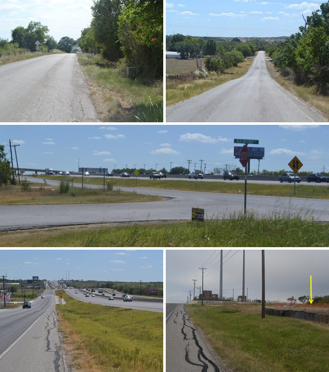
Middle: The cars are following I-35 toward Austin on the branch of El Camino Real that was the early Spanish mission trail. After that route became unsafe, travelers turned here on what became the Old San Antonio Road.
Bottom (l to r): Interstate 35 at the northern outskirts of New Braunfels; site of OSR Marker #77.
Old Bastrop Road and I-35
The Old San Antonio Road crosses from Hays County to Comal County on a road known as Old Bastrop Highway on the Hays County side and Old Bastrop Road on the Comal County side. OSR Marker #76 is at the Comal-Hays County line. Old Bastrop Road ends at Interstate Highway 35 about a mile and a half after entering Comal County.
The intersection of I-35 and Old Bastrop Road is where the historic Kings Highway divided into two branches. The northern branch, represented by I-35, was the main route to the Spanish missions in east Texas during the early 1700s. Historians refer to this route as the "Camino de los Tejas." By the mid-1700s, however, the east Texas missions were closed and the complexion of Spain's relations with the Indian tribes had changed. Out of safety, travelers began taking a more southerly route to Nacogdoches. This southern branch is the route on which the city of Bastrop was later founded - the Old San Antonio Road that V.N. Zively surveyed.
In 1837, the city of Austin was founded on the old Camino de los Tejas as the new capital of the Republic of Texas. This spurred the development of a new road between Austin and San Antonio. This new route included part of the Camino de los Tejas, parts of the Old San Antonio Road, and a new road out of San Antonio originally called Austin Road. It was one of the first roads in Texas to be improved for interstate automobile travel. In 1911, this San Antonio-Austin highway was made part of the Meridian Highway, a cross-country road which started on the Canadian border at Joliette, North Dakota, ran south along the 97th meridian, crossed Texas through Fort Worth, Waco, Austin, and San Antonio, and ended on the Mexican border at Laredo.
The San Antonio-Austin highway soon became part of the state, and later federal, highway system. In 1917, the Texas State Highway Department proposed a system of 26 numbered state highways. The Meridian Highway's Texas segment became part of State Highway 2. It was additionally designated as US Route 81 in 1926. Both numbering systems were used concurrently for a while, but by 1939, the SH 2 designation had been retired in favor of US 81.
Interstate 35 was constructed from San Antonio to Austin between 1960 and 1964. It mostly used the existing route of Highway 81. The roadway retained both designations until 1993, when the Highway 81 designation was removed. The section of I-35 between San Antonio and Austin had an average daily traffic count exceeding 100,000 in 2012.
Zively's route of the Old San Antonio Road includes about 5 miles of I-35 in northeastern New Braunfels. OSR Marker #77 is on this section.
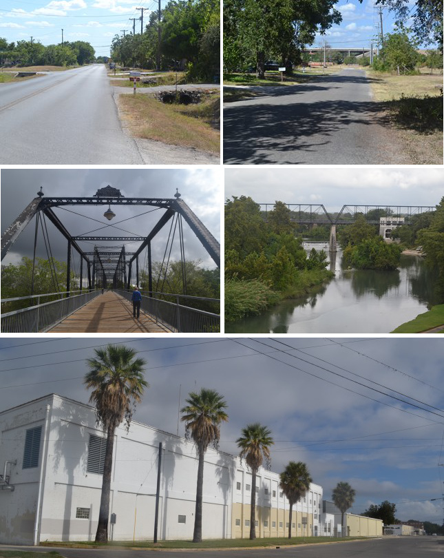
Middle (l to r): Faust Street Bridge; Faust Street Bridge over the Guadalupe River. The dam and a building belonging to the old Mission Valley Mill can be seen behind the bridge.
Bottom: Mission Valley Mill, now closed and for sale.
Post Road and Broadway
As I-35 approaches New Braunfels from the northeast, it curves to the south to bypass downtown. Zively's route of the Old San Antonio Road continues straight, on Post Road. This road passes through a subdivision of small, wood-framed houses, then it turns to run parallel to the Union Pacific Railroad, leading into an industrial area.
Zively's route next transfers to Broadway. Broadway disappears where the railroad passes under State Highway 46, then reappears on the other side. Broadway disappears again a short distance from the Guadalupe River. The missing parts of Broadway are the only parts of Zively's route of the OSR in Comal County that no longer exist, but since the remaining parts of Broadway follow a straight line, it is easy to trace where the route went simply by filling in the missing parts of the line.
The OSR crossed the Guadalupe River at a ford near present-day Broadway. On the west side of the river, the road followed the bank of the river down to Nacogdoches Street, upon which it continued.
In 1887, the Comal County commissioners court contracted for the construction of a bridge over the Guadalupe River, connecting Faust Street on the west side with Porter Street on the east side. The result was the enormous Faust Street Bridge. This bridge became part of the San Antonio-Austin Highway and served as part of State Highway 2 from 1917 until 1934, when a new bridge was built for US Highway 81 at what is now designated SH 46 or I-35 Business. The Faust Street Bridge was closed after a fire in 1979, but is now open to pedestrian and bicycle traffic.
The International & Great Northern railroad was constructed across the Guadalupe River in 1881. Now part of the Union Pacific line, the railroad bridge is approximately midway between the Faust Street Bridge and the original ford crossing of the Old San Antonio Road.
The construction in the late 1800s of the railroad and the new bridge and highway opened up the east bank of the river for settlement and development. A textile mill, originally named the Planters and Merchants Mill, opened in 1923 and constructed a dam across the river for power generation. The mill, which changed names, owners, and products numerous times, became a major industry in New Braunfels, especially after World War II. At its peak, the Mission Valley Mills were a major producer of Bluebonnet gingham and other cotton fabrics and supplied national retailers such as Montgomery Ward, Sears, and J.C. Penney. In 2000, the plant produced 380,000 yards of fabric a week and employed 800 people. The bottom then fell out of the United States textile industry, due to fierce competition from Asia. In 2004, the mill reduced its staff from 72 to 24. The 35-acre, nearly 500,000-square-foot complex is now completely vacant and for sale. The area around the mill is currently being redeveloped as a nostalgia-themed destination for weddings, events, and shopping.
The Faust Street Bridge made the Old San Antonio Road ford unnecessary after 1881, and the mill dam submerged it in 1923. Consequently, the OSR was no longer used for through traffic. This explains why parts of the OSR disappeared in this area. Today, Broadway - the remnant of the Old San Antonio Road - is a dead-end street lined with houses, trees, and open fields, changed little by the rise and fall of heavy industry that occurred just a few blocks to the south.
A state historical marker placed in 1969 between the mill and the east landing of the Faust Street Bridge commemorates the founding of New Braunfels by German settlers and their nearby crossing of the Guadalupe River. A marker placed at the west landing of the bridge in 1999 commemorates the bridge itself.
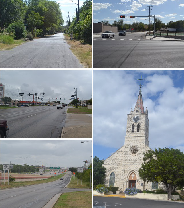
Middle (l to r): Elliott Knox Boulevard; Sts. Peter and Paul Catholic Church, built in 1871.
Bottom: Interstate 35 on the southwest side of New Braunfels.
New Braunfels
The first known settlement in the New Braunfels area was a temporary mission on the Guadalupe River. In 1755, Spain closed the Mission San Francisco Xavier de Horcasitas in present-day Milam County. The natives living at the mission were instructed to go to San Antonio, but one group, the Mayeyes, refused to go. Without approval from their superiors, some of the friars established a mission for the Mayeyes on the Guadalupe River in 1756. All that is known of the mission's location is that it was somewhere near present-day New Braunfels, in a location of good farmland with abundant water and timber.1
This unsanctioned mission, called San Francisco Xavier in some accounts, and Nuestra Senora de Guadalupe in others, was never protected by a presidio. In March 1758, an alliance of Indian tribes headed by the Comanches destroyed the Spanish mission at San Saba. The Guadalupe River mission was considered vulnerable to a Comanche advance, and was abandoned.
The first permanent settlers at New Braunfels were German immigrants who arrived at the confluence of the Comal and Guadalupe Rivers on March 21, 1845. Led by Nicolaus Zink, they built a temporary fort called Zinkenburg about a mile north of the Old San Antonio Road, at present-day Zink Street and Castell Avenue. With more Germans arriving regularly, the town's population was up to 300 to 400 by that summer, and a permanent townsite was well underway. It was named after Braunfels, the name of the estate of the German immigrants' first commissioner-general, Prince Carl of Solms-Braunfels.
New Braunfels, populated with farmers, merchants, craftsmen, and artisans, quickly emerged as a manufacturing and trading center, supplying central Texans with wagons, farming implements, furniture, clothing, and leather goods. Its population was reported as 1,727 in 1858, making it one of Texas' ten largest cities. It was also among the first towns in Texas to establish a taxpayer-funded school system.
The Saints Peter and Paul Catholic Church was built in 1850 at the site of the original Zinkenburg settlement. The current limestone building was constructed around the original walnut lumber building in 1871.
New Braunfels continued to grow and prosper throughout the 1800s and 1900s. Tourism and recreation, centered around the area's natural beauty and attractions, flourished beginning in the mid-20th century. Area tourist attractions include tubing and canoeing on the Guadalupe River; Natural Bridge Caverns, opened in 1964; Canyon Lake, also opened in 1964; and Schlitterbahn water park, opened in 1979. New Braunfels doubled in population from 1970 to 2000.
After crossing the Guadalupe River, Zively's route follows Nacogdoches Street, Elliott Knox Boulevard, and I-35 on its way through town. OSR Marker #78 is at its original location at the intersection of Nacogdoches Street and Seguin Avenue. Parts of Nacogdoches Street are residential and older-looking, but Elliott Knox Boulevard and I-35 are completely modern and commercial.
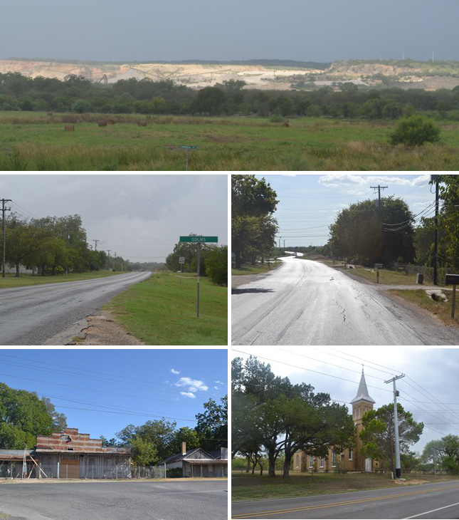
Middle (l to r): Solms highway signpost; site of OSR Marker #79.
Bottom (l to r): Vacant buildings at Comal; St Joseph Church, built in 1905.
FM 482
The historic route between New Braunfels and San Antonio is well-preserved. It runs alongside I-35, staying about a mile or two to the north of the freeway. It begins on the southwest side of New Braunfels as FM 482.
Zively's route between San Antonio and New Braunfels intertwines with two lines of the Union Pacific Railroad, which serve several quarries that are along the route. With the quarries, trains, frequent railroad crossings, and freight trucks, there is an industrial character throughout this section of the Old San Antonio Road, but at the same time, much of it is still rural and undeveloped.
Many of the streams west of New Braunfels were named according to their distance from the town, thus there is a Three Mile Creek, Four Mile Creek, and so on. A town on the OSR originally taking the name of the nearby stream, Four Mile Creek, was established in the late 1840s. Four Mile Creek had one of the first cotton gins in the county in 1857. Some time after 1880, the town was renamed to Solms, after German immigrant commissioner-general Prince Carl of Solms-Braunfels. Solms had a post office from 1894 to 1902. It exists today as a small, unincorporated community of 40 just outside the New Braunfels city limits.
OSR Marker #79 is on FM 482 at Solms. Homes and businesses share this part of the road.
In 1846, a year after New Braunfels was founded, some of its families left the prospering city to establish a second German community. This town, named Comal2, was seven miles southwest of New Braunfels, where the Old San Antonio Road made a 90-degree turn at what is now the intersection of FM 482 and Old Nacogdoches Road. The most prominent family in the new settlement was that of Peter Ignatz Wenzel and his wife, Anna. Peter donated three acres for a school, built in 1868. After his death in 1884, Anna donated one acre for a cemetery. A chapel was built next to the school in 1905. Comal was primarily a farming community, but it did have a train station, a grocery store, and a blacksmith shop.
Today, Comal is an unincorporated village of 40 people, most of whom are descendants of the original settlers. The cemetery, formally called St. Joseph Cemetery, but also known as Wenzel Cemetery or Seven-Mile Cemetery (or, less accurately, Eight-Mile Cemetery), is still used today, mainly by members of the large Wenzel family. The St. Joseph school closed in 1941 and was dismantled in 1959, but the chapel built next to it still stands. Both the cemetery and chapel have been recognized as historic sites by the historical preservation committee from the nearby city of Schertz.
At Comal, FM 482 continues west, while Zively's route turns north onto Old Nacogdoches Road. Zively showed the continuation of FM 482 on his sketch, labeling it "Post Road." According to a historical marker sign placed there by the Schertz Historical Preservation Committee, this road was also a route of El Camino Real. If so, it may have been part of the 18th-century Camino de los Tejas route that preceded the Old San Antonio Road.
Middle (l to r): Site of OSR Marker #80; Nacogdoches Loop.
Bottom (l to r): Railroad scale across the street from the cotton gin in Bracken; store and bowling alley in Bracken.
Old Nacogdoches Road
The OSR splits off of FM 482 at the old site of the town of Comal. From there, it is called Old Nacogdoches Road. It is also designated as FM 1337. It passes through pastures and fields of cotton and other crops, making this the most rural and agricultural part of Comal County seen along the Old San Antonio Road.
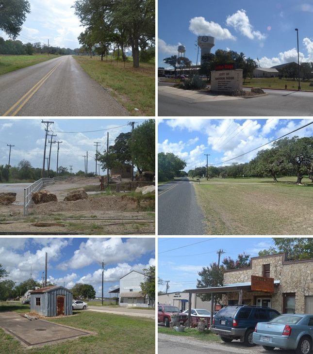
Before long, one begins to see businesses, industries, schools, and churches of the San Antonio suburbs. The first such town is Garden Ridge, a newer community, incorporated in 1972. Its population has risen in pace with the growing population of nearby San Antonio.
The Hansen Servtex limestone quarry is within the eastern city limits of Garden Ridge. OSR Marker #80 is on the grounds of the quarry offices.
At Garden Ridge, Old Nacogdoches Road's numerical designation changes to FM 2252. About a mile of FM 2252 in Garden Ridge is new. The historic route is preserved as "Old FM 2252", also called Nacogdoches Loop. It passes through a semi-rural neighborhood featuring large front yards and majestic hardwood trees.
Just before crossing into Bexar County, one finds the little town of Bracken along the railroad tracks on the south side of Old Nacogdoches Road. The land here was granted to William Bracken in 1850. He then sold some parcels to families who wanted to settle there. A church building was erected in 1872; a school followed. The International & Great Northern Railroad built through the area in 1881. In 1890, the town of Davenport, named after one of the early settler families, was founded. It changed its name to Bracken in 1899 after it applied for a post office and found that the name Davenport was already taken.
The railroad was central to Bracken's early growth. The railroad built a depot that included a water tower and pump for the train's steam engines, a ticket agent, and a freight office. Business owners also put up a cotton gin, blacksmith shop, two general stores, and an inn. This railroad boomtown even had a doctor, a dentist, and an undertaker. The most notorious businesses of all, however, were the dance hall and the saloons. They were rowdy places, known for many fights, several of which led to killings. On the other hand, residents with gentler ideas of entertainment joined the bowling club. The Bracken Bowling Club, founded in 1914, was one of several nine-pin bowling clubs that flourished in the predominantly German parts of Comal, Bexar, and Guadalupe Counties. A bowling alley was built in Bracken in 1915, the same year Mr. Zively passed through, making his survey. One can only wonder whether he made a stop at Bracken to enjoy himself and, if so, which form of entertainment he chose.
Bracken was hit hard by two events of the early 20th century: Prohibition, which became law in 1920, and the decline of the railroads. The saloons and dance hall closed down. The railroad station closed. Most of the other businesses followed suit. The post office was closed in 1940. The population of Bracken has been steady around 75 since the 1970s. One store - built in 1935 after the original building burned down - still stands on 2nd Street. A few newer businesses have also appeared in recent times, as San Antonio's population has grown. The bowling alley and club also remain. Wednesday night is league night.
Page last updated: October 22, 2014
1A state historical marker in Landa Park named "Site of Nuestra Senora de Guadalupe Mission" commemorates the mission, but the marker's location should not be taken as significant.
2Zively labeled it as "Comaltown" on his sketch, but it is distinct from the New Braunfels ward named Comal Town.
- Zively, V.N. - "Field Notes and Detail Map of the Kings Highway", 1916
- Carson, David - field notes observed and recorded in 2014
- Texas State Historical Association - The Handbook of Texas Online
- Bindseil, Carolyn - "Story of Bracken, Texas", 2007