
The Old San Antonio Road Posts and Markers in East La Salle County
The Old San Antonio Road Posts and Markers in East La Salle County
- Map of the Old San Antonio Road in East La Salle County
- Markers Moved by Judge J. W. Martin
- Marker #100
- Post A
- Marker #101
- Marker #102
- Marker #108
- Marker #109
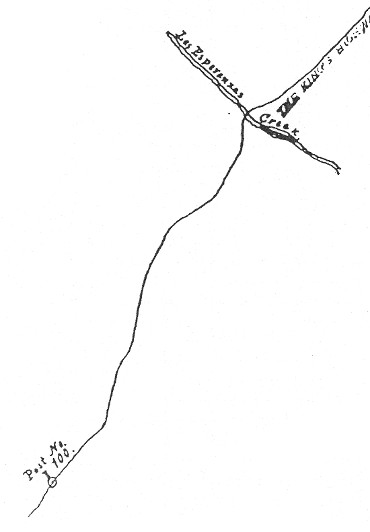
Zively placed eleven oak survey posts for the Old San Antonio Road in La Salle County. Six of them were placed in the eastern part of the county shown on this map. One of those, labeled "Post A," did not receive a numbered granite marker, and another was lost long ago. The other four were moved to State Highway 97 in the 1950s and no longer mark Zively's route.
Map of the Old San Antonio Road in East La Salle County
[-]Collapse Map [+]Expand Map
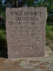
The Texas Society Daughters of the American Revolution undertook an effort between 1995 and 2001 to document and rededicate the Old San Antonio Road granite markers. On the DAR's project web page for La Salle County, there is a note reading as follows:
St. Hwy. 97 followed the original Kings Highway for several miles in La Salle County and then veered off for several miles. Judge J. W. Martin, County Judge (1951-1969) in the 1950's, wanting to protect the Markers and preserve them for all to see, had #'s 101, 102, 108 and 109 moved to line the highway right-of-way into the town of Cotulla.
As the above map shows, the statement that Highway 97 followed the Kings Highway for several miles is incorrect. The route between Fowlerton and Cotulla now designated as Highway 97 was built in 1926. The first 12 miles from Fowlerton used an existing road that went to Gardendale, but the 15 miles between FM 469 and Cotulla did not previously exist in any form. The Kings Highway, on the other hand, came in from the northeast corner of the county and went southwest until it reached present-day FM 469, then it followed present-day Altito Rd and Guadalupe St into Cotulla. Highway 97 simply had nothing to do with it.
The markers that Judge Martin moved are on the eastern part of Highway 97, along the original Fowlerton-Gardendale road. Apparently, the markers closer to Cotulla - #110 and #111 - had already been moved to the all-new western section of Highway 97 by the 1950s, thus giving the DAR and Judge Martin the mistaken impression that Highway 97 was a remnant of the Kings Highway. Those markers must have been moved there when the road was constructed in 1926, or some time not long afterward.
The end result of moving all of these granite markers to Highway 97 is that they tell a false story, which is that the Kings Highway went from Cotulla to Fowlerton along Highway 97. It actually did not follow Highway 97 at all, and did not come within 8 miles of Fowlerton.
The state of Texas and the DAR did a service to history by sending Mr. Zively to survey el camino real and by marking his trail with these large blocks of granite. Public funds and private donations were spent with the object of preserving the historic route for future generations. It is a shame that this work was so utterly undone in La Salle County within only 40 years by people who either misunderstood or forgot why the project was undertaken.
|
Marker #: 100
Coordinates: N/A Location: Not found Marker #100 was placed in northeastern La Salle County between Esperanza Creek and the Frio River. It has never been documented. All roads leading to the vicinity of the marker's original location are now closed to public traffic. Observed on July 11, 2015. |
|
|
Post A
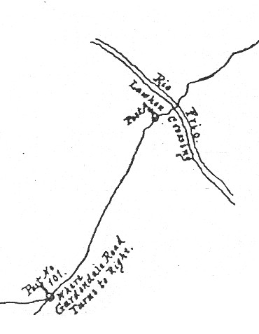
The Kings Highway crossed the Frio River at a place Zively referred to as "Lawhon Crossing." This location is unknown. There are no known Frio River crossings in the vicinity of the location Zively marked. The surname Lawhon appears in La Salle County records from the 19th century, but we have not found any documents or maps that indicate whose parcel of land Lawhon Crossing was on, or where it was. We have found no historical references to Lawhon Crossing or Lawhon Ford except for a few that use Zively's notes as their source. According to his sketch, the location where Zively placed his survey post is at about the same latitude as present-day Hindes Road. This road is closed to the public 3½ miles from the Frio River. The last survey post Zively placed before reaching this spot was #100, so this one should have been #101. Zively did something unique at this location, however: he labeled it "Post A." He left no explanation for doing so. Perhaps he had already placed Post #101, and then he decided to backtrack and place a survey post on the Frio River. There is also no record of whether a granite OSR marker was placed at this location. If there was one, it has never been found. Observed on July 11, 2015. |
|
|
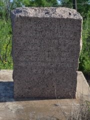
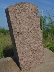
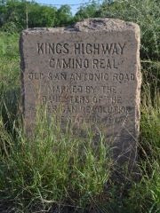
Marker #: 101
Coordinates: 28.462947, -98.816203 Location: Highway 97 near Fowlerton Relation to Road: 30 ft from south stripe, oriented NW 330° Distance from post: 8.7 mi southeast of post, off route Dimensions: 33" x 26" x 12" Setting: Concrete pedestal Other Markers/Signage: No Visibility: High Accessibility: Good This marker is on State Highway 97 just outside the town of Fowlerton. It is 0.2 miles west of Sherman Ave. It can easily be seen mounted on a 12"-high concrete pedestal on the south side of the highway, on top of a low ridge. Parking is available directly across the road from the marker, on a wide shoulder in the shade of a large mesquite tree. There is an impact mark, presumably from a gunshot, on the face of the marker, below the lettering. A large crack stretches horizontally all the way across the face from the point of impact. This damage is not evident in the photograph the Texas Society Daughters of the American Revolution (DAR) made between 1995 and 2001. This is one of the four markers moved by La Salle County Judge J.W. Martin in the 1950s and the one that was moved the farthest. Its original location was near the Frio River, about 7.5 miles south of the Frio-La Salle County line and 8 miles west of the La Salle-McMullen County line. Zively noted that he placed the survey post where the Gardendale road intersected with the Kings Highway (see the sketch under the heading, "Post A", above). This would have to be a different road than the one that connected Gardendale and Fowlerton in the early 20th century. Observed on April 25, 2015. |
|
|
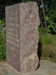
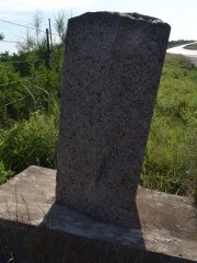
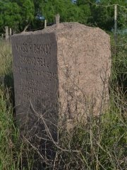
Marker #: 102
Coordinates: 28.436380, -98.879290 Location: Highway 97 west of Fowlerton Relation to Road: 35 feet from south stripe , oriented N 0° Distance from post: 5.6 mi southeast of post, off route Dimensions: 34" x 25" x 18" Setting: Concrete pedestal Other Markers/Signage: No Visibility: High Accessibility: Excellent in dry weather This marker is on Highway 97, 4.6 miles west of Sherman Street in Fowlerton. It is 4.2 miles west of OSR Marker #101. It is in front of a barbed-wire fence for an uncleared field on the south side of the highway. It is mounted on a 12" concrete pedestal. Part of the earth supporting the pedestal has washed out, and consequently the marker leans about 20 degrees forward and about 5 degrees to the right. The marker itself is clean and free from damage. In the photo made by the Texas Society DAR around 1995, the marker and pedestal are level, but much of the earth underneath the pedestal had washed out. A Google's street view photo made in December 2007 shows the marker leaning at about the same angle that it has today. Despite its unsteady appearance, the marker does not seem to be at any risk of toppling in the near future. There is a dirt pulloff in front of the marker. It is perfectly suitable in dry weather, but has the potential of turning into mud after a rain. This is one of the four markers moved by La Salle County Judge J.W. Martin in the 1950s. Its original location was south of Cibolo Creek, about 1.5 miles north of Highway 97 and 3 miles west of the Frio River. Observed on April 25, 2015. |
|
|
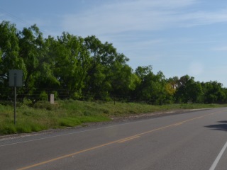
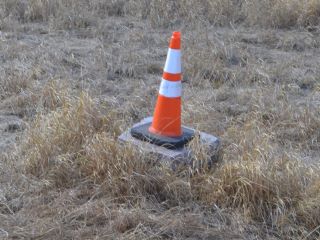
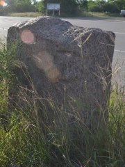
Marker #: 108
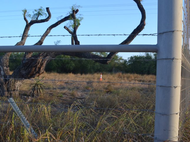
Coordinates: 28.443396, -98.932342 Location: Highway 97 east of FM 469 Relation to Road: 50 feet from south stripe Distance from post: 3.2 mi northeast of post, off route Dimensions: 24" x 24" x 14" (section) Setting: On top of the grass Other Markers/Signage: No Visibility: Low Accessibility: None This marker is lying in a field on the south side of SH 97, about 4.4 miles east of Farm-to-Market Road 469. The field is private property on the Donnell Ranch, The marker is just inside a ranch gate. It is lying face up on top of the ground. An orange traffic cone is on top of it, undoubtedly to alert mowers to its location. The cone is visible from the highway, but the marker itself is not. By pulling into the entrance of the ranch gate, it is possible to get within about 30 feet of the marker without crossing the property owner's fence. A large piece of the marker - approximately the bottom third - is broken off and is missing. The Texas Society DAR documented Marker #108 at or near this location between 1995 and 2001. Their photo shows it lying face up in a prickly pear stand. The bottom of it is broken off and missing. In their photo, the remaining part of the marker appears to badly cracked or broken into two pieces, but this is actually nothing more than a shadow cast by a weed. The coordinates given by the DAR match this same general area. The DAR's notes do not indicate that the marker was on private property when they found it, but it probably was in this same field, either in the same exact spot, or somewhere close by. It was probably not in the highway right-of-way, for the highway department keeps the cacti cleared from the right-of-way. Marker #108 was originally placed about 2.3 miles south of SH 97, about 1.0 mile east of FM 469. Zively placed a survey post there to indicate where the Lower Presidio Road branched from the Laredo Road. In the 1950s, Judge Martin had Marker #108 moved to SH 97. The current landowner, who granted us access to view the marker, informed us in 2015 that it was previously on the highway side of the property fence, but the fence was subsequently moved closer to Highway 97. The DAR noted of the marker, "It was broken after being moved." How the marker got broken, and where the rest of it is, are questions we cannot answer. Observed on August 9, 2015. |
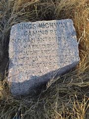
   Below: The Texas Society DAR's photo of Marker #108, made circa 1995. 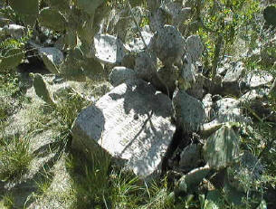 |
|
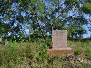
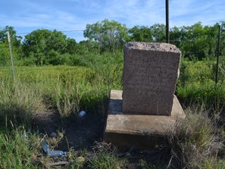
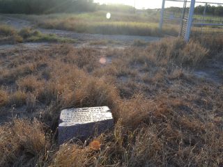
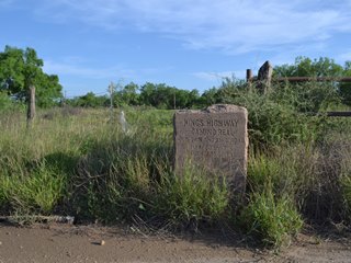
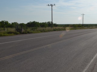
Marker #: 109
Coordinates: 28.465673, -99.000933 Location: Highway 97 at FM 469 between Fowlerton and Cotulla Relation to Road: 14 feet from south stripe, oriented N 350° Distance from post: 2.9 mi north of post, off route Dimensions: 37" x 27" x 16" Setting: Weeds at road's edge. Other Markers/Signage: No Visibility: Medium Accessibility: Excellent This marker is on Highway 97 at the intersection of FM 469, about halfway between Fowlerton and Cotulla. It is 200 feet west of the intersection at the edge of a wide dirt shoulder on the south side of the highway. It is in front of a fenced-in grassy field, amidst a patch of weeds just beyond the edge of the road. It is in a concrete base covered by an inch or so of soil. The face of this marker is very weathered, with no gloss left. Considering how much dirt is blasted onto it every day by truck traffic passing by at 70 mph, it is no wonder. The face of the marker is 34" high, but there is a hump on top that brings the total height to 37". This is one of the four markers moved by La Salle County Judge J.W. Martin in the 1950s. Its original location was near the intersection of present-day FM 469 and Mumme Road, about 3 miles south of its present location. Observed on June 6, 2015. |
|
- Carson, David - field notes observed and recorded in 2015
- Zively, V.N. - "Field Notes and Detail Map of the Kings Highway", 1916
- Texas Society Daughters of the American Revolution - Old San Antonio Road DAR Marker Information Site