
Using Lidar to Map El Camino Real in San Augustine
Using Lidar to Map El Camino Real in San Augustine
Introduction
V. N. Zively's 1915 survey of the route of the Old San Antonio Road is preserved in a book of 114 pages of survey sketches and field notes that describe the road foot-by-foot from the Sabine River to the Rio Grande. Each page of Zively's sketch book represents about five miles of the route. Out of all of the survey sketches Zively made, none of them is more difficult to interpret than Page 6, which depicts the route of the Old San Antonio Road around the city of San Augustine. In this article, we use lidar analysis to shed some light onto this troublesome area.


A Brief History of San Augustine
In the late 1600s and early 1700s, Spain founded six Franciscan missions in east Texas and west Louisiana. To the Franciscans, The purpose of these missions was to teach Christianity to the natives. To the Spanish crown, however, they served a more strategic purpose of defending Spain's territorial claim to Texas.
One of these missions was to the Ais tribe, which lived along Ayish Bayou. The mission, which was called Mission Dolores, was founded in 1717. It was abandoned in 1719, then re-established in 1721. The mission building was located on the east bank of Ayish Bayou next to a small hill that Anglo settlers would later call Mission Hill.
The six missions were connected to each other and the town of San Antonio by El Camino Real. This road came in from the west from Mission Guadalupe in present-day Nacogdoches, crossed Ayish Bayou, passed by the south side of Mission Hill and through Mission Dolores, then continued east to Mission San Miguel near Natchitoches, Louisiana.
When establishing these missions, Spain hoped that the natives would settle in them and form permanent communities, with the mission as the center and farms surrounding it. But while the natives tolerated, and even welcomed, the Spanish presence in their land, they had little interest in Christianity and even less interest in giving up their nomadic lifestyle to take up farming. With few converts and dwindling government support, three of the east Texas missions relocated to central Texas in 1729, leaving only Mission Dolores, Mission Guadalupe, and Mission San Miguel. These three missions were no more successful in converting the natives, but they remained in the area for another 44 years, serving as a deterrent to French encroachment from Louisiana. After France ceded its American claims to Spain, however, Spain felt it was time to close these unproductive outposts. Mission Dolores was abandoned in 1773.
Even though the Spanish government and the Catholic Church saw no reason to stay in east Texas, individual citizens and settlers saw opportunities there. Antonio Leal received a grant of ten leagues, or about 70 square miles, along Ayish Bayou on the north side of El Camino Real. American and European settlers also streamed in on the road from Louisiana. Edmund Quirk bought the Leal grant in 1801. The Ayish Bayou district grew in population such that in 1832, now under the Mexican government, it was recognized as a municipality, to be called San Augustine. Local leaders chose the location north of the road and east of Ayish bayou for their townsite and bought the land from Quirk.
Figure 1 is a section of a San Augustine County land grant map from 1901. It shows how El Camino Real - known at the time as the Kings Highway - was recognized as the southern boundary of the Edmund Quirk survey. It came in from the west, dipped south to cross Ayish Bayou, then rose back up. It made a wavy line as it went east and crossed Carrizo Creek. We do know that at the time of these early land abstract surveys, El Camino Real was not a fixed series of survey points, but was a set of small routes adjusted for weather, ruts, erosion, elevation, flooding, etc. The Kings Highway illustrated in the 1901 maps shows the general direction and bends in the road pattern at the time that adjusted for terrain and elevation changes. Where the road crossed the southeast corner of Quirk's survey, it straightened out and went east-southeast out of the county. One of the parcels that it passed through was that of Elisha Roberts, one of the founders of San Augustine.
The east Texas missions were not like the large, sturdy stone missions one sees in San Antonio. Instead, they were small, crude, and made of wood. The abandoned structures deteriorated quickly in the humid Piney Woods. By the time the city of San Augustine was founded, there was nothing left of the mission except for some graves, and it had been long forgotten. In other words, there was nothing important about the mission site to the residents of San Augustine except that it was where Ayish Bayou could be crossed. But, as Figure 1 shows, this crossing was at the extreme southwest corner of the townsite, so the more the town grew, the further residents had to walk from the center of town to cross the bayou.
Figure 2 is a map of the city of San Augustine from 1850. It shows how the city was originally laid out. Broadway - present-day Highway 147 - was the principal north-south street and led to the Ayish Bayou crossing. Main was the principal east-west street and led to the Carrizo Creek crossing. The Old Kings Highway curved around Mission Hill, cut across Broadway, and went east. It then turned northeast and nicked the corner of Planters and Ayish Streets. This map makes it appear as though the Old Kings Highway continued to a few feet past Columbia Street before making a sharp right turn to go to Carrizo Creek.
Figure 3 is a section of a road map of San Augustine County from 1910. As on the 1901 map, the Old Kings Highway came in from the west (this section was also called the Lower Nacogdoches Road). It dipped south, crossed Ayish Bayou, returned to the north, crossed Carrizo Creek, and then headed east-southeast out of the county. Note that most of the roads coming in from the west converged so that they crossed Ayish Bayou at the same place, and most of the roads coming in from the east converged so that they used a single crossing of Carrizo Creek. The exceptions were some newer roads that crossed both Ayish Bayou and Carrizo Creek north of their historic crossings. The new Ayish Bayou crossing went through the town center and allowed travelers to go into or through San Augustine without having to detour around the south side of it first.
Significant changes occurred in the early 1900s. The city expanded and added streets beyond the original grid. The Old Kings Highway route around the south side of town, which was no longer needed, was developed over. These changes were completed by 1918 and are illustrated in Figure 4, which is a road map from 1940. Note that there is no longer a road that goes around the south side of San Augustine; only one that goes through downtown. The routes coming in from the west now converge to use the more northern crossing of Ayish Bayou; only State Highway 147 still uses the original crossing. The original crossing of Carrizo Creek, which is labeled as Caney Creek on this map, is still used as a main east-west crossing and is where two roads converge.
The Problem with Zively's Route Between Posts #6 and 7
As we saw in the above section, some segments of El Camino Real have been erased in San Augustine. Based on the 1910 road map shown in Figure 2, when Zively did his survey in 1915, the old Kings Highway still existed in some form. We should expect his survey, then, to be helpful in reconstructing the missing segments of the route. It is not, however, for reasons which are illustrated and explained below.

Figure 5, above, shows the difficulty with interpreting Page 6 of Zively's sketchbook. The top image in Figure 5 shows Zively's sketch aligned on a modern road map so that Post #7 is in the correct location at Ayish Bayou and Mission Hill. Point A, the convergence of the Kings Highway with the newer road, is also at the correct location. Point B, the crossing of Carrizo Creek, is a little too far south, however - it should be at the present crossing of State Highway 21. Point C, the southeast corner of the Edmund Quirk survey, is way too far south - it should be at about the same latitude as Post #7. Post #6, at Elisha Roberts' house, is also too far south.
The middle image of the set shows Zively's survey with Post #6 lined up correctly. It is easy to see that present-day Highway 21 matches Zively's survey perfectly for several miles on either side of Post #6. Going west, however, once it leaves Highway 21, it is difficult to follow. Point C is now approximately at the correct latitude, but point B, the crossing of Carrizo Creek, is too far north. Post #7 and Point A are way too far north.
In the bottom image of the above set, we have superimposed Zively's sketch with each post in the correct location, but with routes going between them that do not connect. We know that neither route can be completely correct, but is one more correct than the other? Where did Zively make his error, and is there an explanation for it? The answer may be as simple as rotating part of his drawing. All of Zively's survey sketches included a north-south line for reference. Suppose that while Zively was making out his survey sketch, the paper rotated, unknown to him, and then before he finished the sketch, he rotated it back to its correct position. Such an occurrence would cause the left and right sides of the drawing to be oriented correctly, but the middle to be wrong. That could well be what happened here. Our theory is that somewhere around Point C - since Zively worked from east to west - the page rotated, and then around Mission Hill, he straightened it out.
To test this theory, we cut the segment of Zively's drawing from the Quirk survey boundary to Mission Hill and rotated it counter-clockwise until the ends connected. The amount of rotation required was 6 degrees. The result is shown below in Figure 6.

The results of this experiment are promising. Most significantly, the road's crossing of Carrizo Creek is now perfect. There also seems to be some correspondence between Zively's route and FM 3483 east of Carrizo Creek and Highway 21 west of it. Our theory that part of Page 6 of Zively's sketchbook was drawn at an incorrect orientation is worth further examination.
Another possible error with Zively's survey has to do with his data. As with all professional surveys, Zively did not simply produce drawings, but accompanying each drawing, he included data points, which are given as the distance and direction from the previous data point. Unfortunately, his writing is small and barely legible, and the copy of his survey that was available to us is a poor-quality reproduction in which portions of the page are unreadable. Nevertheless, it can be made out that there are two columns of numbers, with the sum of the left column being 10,601 feet and the sum of both columns coming to 22,646 feet. This means the sum of the right column of numbers should be 12,045 feet. By examining all of the individual data points in the left column, we can corroborate the intermediate sum of 10,601, but we cannot make the second column total 12,045. Our best interpretation is that there is 579 feet of survey data missing in the right column, which starts somewhere about ½ mile west of the Quirk boundary and ends at Post #7.
Adding Lidar Analysis
The above sections of this article have explained the historic context of El Camino Real in San Augustine and demonstrated the problems with Zively's survey. We have discussed two possible errors with the survey and have devised an interpretation of it that may have been closer to what Zively intended. It is now time to add information obtained from lidar analysis. Figure 7, below, shows lidar imagery of the area between Posts #6 and 7. Modern roads are shown in yellow. We have used light blue to mark evidence of old travel routes. Our interpretation of Zively's survey, including the 6-degree counterclockwise reorientation discussed above, is shown in the bottom image in brown.

Working from east to west, the images show that Highway 21 follows the historic route northwest from Post #6 for a little over a mile, but then the two roads separate. Highway 21 stays on high ground and makes a more pronounced descent toward Carrizo Creek, while the historic route made a smoother, more constant descent. The historic route is probably the one that Zively traveled on himself, so one can only speculate as to why the brown line does not follow the light blue line. Perhaps our decision to rotate a section of Zively's survey counter-clockwise by 6 degrees was wrong, or perhaps we chose the wrong point to begin the rotation. Perhaps this is where the 579 missing feet from his data come in. Or, perhaps Zively deliberately went off the beaten path, thinking he was following the historic trail. The latter explanation might actually be the most likely, because it looks like when he hit the road to Bronson - present-day FM 3483 - he included part of it in the Old San Antonio Road, which he should not have done.
Old maps show that roads from the 19th century to today, including Highway 21, have used the same crossing of Carrizo Creek. This crossing is also supported by lidar imagery. If our rotated version of Zively's sketch is correct, he also crossed at this location. He then followed the well-known road for about half a mile before making his way down to Mission Hill. The absence of light blue traces along Zively's route is not significant, for this area has been developed over, so any old road traces would no longer be visible. Still, his route from what could be Columbia or Main Streets to Mission Hill does not make much sense, for it includes an unnecessary 50-foot climb in elevation followed by a 50-foot descent. A more curved route through the east and south side of town, as depicted in Figure 2, would have allowed travelers to stay at a more constant elevation. Once again, there is no way to know for certain whether Zively followed the correct route, but made mistakes when preparing his survey that have caused us to interpret it incorrectly, or whether he followed an incorrect route.
In conclusion, lidar analysis of El Camino Real in San Augustine does confirm that the current crossing of Ayish Bayou at Highway 147 and the current crossing of Carrizo Creek at Highway 21 were the historic crossings and that the city of San Augustine was built on the north side of the road. The depiction of the Kings Highway on maps from 1901 and earlier is probably an accurate depiction of the road as it existed in the 1700s, particularly in the way that the road curved around the south side of town. There is conclusive evidence of an old road that went from Carrizo Creek to the southeast corner of the Quirk survey, and thence to Post #6, that was used before Highway 21 was built. Unfortunately, lidar analysis does not answer the question of what is wrong with Zively's survey. It looks like there is an orientation problem with part of it, and it looks like there might be some missing data, but even taking those issues into account, it seems like he got off course at least once.

Mission Dolores
Because Mission Dolores was the original destination on El Camino Real in the vicinity of San Augustine, it makes sense to focus some of our attention on it. Figure 8, above, is our lidar-assisted interpretation of this area. In this instance, the brown line represents our best interpretation of El Camino Real. Let us first look at the key features of this route. El Camino Real crossed Ayish Bayou at the same location used today by Highway 147. The current highway follows the general path of the historic route from there for about 0.4 miles. The orange polygon shows the outline of Mission Hill. Today, Highway 147 cuts through the edge of the hill, whereas the historic route curved around it. The green rectangle is the approximate site, according to prior archeology work, of Mission Dolores. Note that El Camino Real ran through the center of the mission. After leaving the mission site, Highway 147 follows the approximate route of the old trail for about another 1,000 feet, then it bends north to go to downtown San Augustine, whereas El Camino Real turned right to go to Carrizo Creek. The map also shows the original location of Zively's Post #7 and the current location of OSR Marker #7.
We have used purple lines to mark what appear to be remnants of other old trails in the Mission Hill area. Some of these trails were undoubtedly used by residents of San Augustine who needed to come down to Mission Hill to cross Ayish Bayou. There were also some 19th-century dwellings in this area; some of the trails would have been used by their residents when going back and forth to town. Some of these trails, especially those in the lower part of the image, may even date back to the time of the mission.
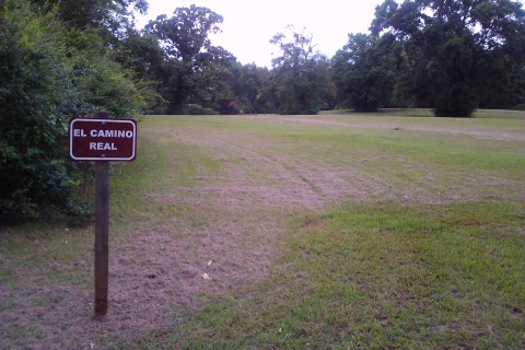
Finally, we note that on the road leading south, away from the mission site, into a campground, there is a sign that reads "El Camino Real." The sign stands more than 200 feet from the known route of El Camino Real. It faces east, meaning one looks to the west to read it. Based on our site visits, this purported view of El Camino Real looks like nothing but an ordinary field of mowed grass. Our analysis of the lidar imagery corroborates this impression, for we see no trail, rut, or swale of any kind there.
By David Carson and Darrell Hebert
Page last updated: May 30, 2019
- Texas State Historical Association - The Handbook of Texas Online
- University of Texas at Austin - Texas Beyond History