The first Europeans arrived in Texas in 1528. These men, mostly Spaniards, who were survivors of the Narváez Expedition to Florida, lived among the Texas natives for six years. One of the Spanish survivors, Alvar Nuñez Cabeza de Vaca, gave an account of his journey, known as La Relación. Cabeza de Vaca's account is filled with vivid and detailed descriptions of the appearance, lifestyle, and customs of the many native tribes with whom he and his fellows lived.
Cabeza de Vaca's description of the natives of Texas is valuable not only as the first anthropological record of American Indians, but also for the information it provides about where he traveled. His description of where each tribe lived in relation to the other, which ones lived on the coast versus inland, and of their hunting, feeding, and fishing habits goes a long way toward helping us reconstruct his route along the Texas coast. This article analyzes the information Cabeza de Vaca provides about the native tribes with an emphasis on locating them on a map of the Texas coast, giving us a better picture of the route he and his fellow Narváez Expedition survivors took.
It should be emphasized that all of the native tribes Cabeza de Vaca encountered on the Texas coast were nomadic. That is, instead of living in fixed towns or villages, they moved frequently. This does not mean, however, that they wandered aimlessly. Generally speaking, each tribe had its favorite spots for fishing, picking berries, gathering nuts, etc. and it would visit each spot during its season of greatest productivity. The natives' annual migratory habits were regular enough that some tribes knew that they could expect to see their neighbors arriving at a certain place on a certain day. So, even though these natives did not have fixed homes, each tribe did have a known territory. Some of the natives' territories overlapped, to the extent that some feeding grounds were visited by more than one tribe at the same time.
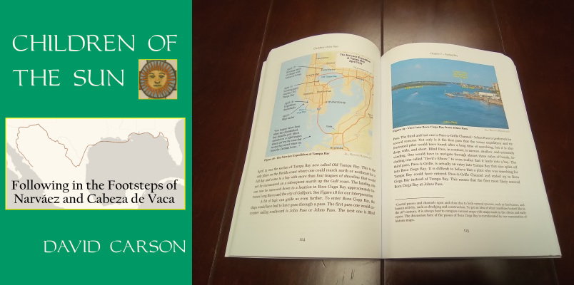
Order your copy of Children of the Sun: Following in the Footsteps of Narváez and Cabeza de Vaca, by David Carson of TexasCounties.net, available in E-book and paperback formats.
Cabeza de Vaca discusses the natives of the Texas coast throughout his narrative, but there is one place where he brings them all together in a handy summary. Chapter 26 of La Relación, which is sometimes headed "Of the nations and languages," begins as follows:
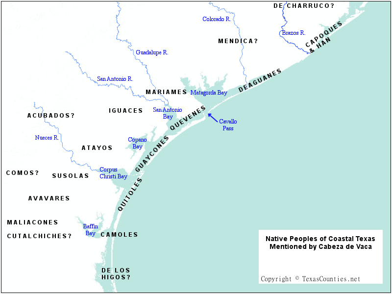
I also want to describe their nations and languages, which are from the Island of Misfortune to the last ones. On the Island of Misfortune there are two languages, some called Caoques and others called Han. On the mainland, facing the island, there are others who are called "of Chorruco"; they take the name of the woods where they live. Further on the sea coast, others dwell who are called Doguenes, and facing them, others by the name of Mendica. Even further on the coast are the Quevenes, and facing them, further within the mainland, the Mariames. Going further along the coast are others who are called Guaycones, and facing them, within the mainland, the Iguaces. At the end of these are others who are called Atayos, and in back of these, others, Acubadaos. There are many on the path ahead of these. Others called Quitoles live on the coast, and facing these, within the mainland, the Avavares. The Maliacones are joined with these, and others, Cutalchiches, and others who are called Susolas, and others who are called Comos, and further on the coast are the Camoles. Further on the same coast, others who we call "those of the figs." - La Relación 26:1
The "Island of Misfortune" mentioned in the first sentence is present-day Follet's Island in Brazoria County (for further discussion, please see our article, "Identifying the Isla de Malhado"). From that starting point, Cabeza de Vaca lists the tribes in geographical order, moving from northeast to southwest along the Texas coast. As he lists them, he classifies them as either living on the coast or on the mainland (tierra firme, or "solid ground"), and he also indicates which mainland tribe lived across from (or "facing") which coastal tribe. Table 1, below, shows this information about the tribes in a condensed form.
Location
Southwest
Northeast
Mainland Tribe(s)
Comos Susolas Cutalchiches Maliacones Avavares
Acubadaos Atayos
Iguaces
Mariames
Mendica
"Of Chorruco"
Coastal Tribe
"Of the Figs"
Camoles
Quitoles
Guaycones
Quevenes
Doguenes
Caoques and Han
Table 1. The tribes of the Texas coast listed in Chapter 26 of La Relación.
"They were the most savage looking human beings I ever saw."
The colonization law exempted from settlement all land within twenty-five miles of the coast, so the territory was given over to the Karankawa Indians, a fierce tribe, whose hand was against every man. They lived mostly on fish and alligators, with a man for fete days when they could catch one. They were the most savage looking human beings I ever saw. Many of the bucks were six feet in height, with bows and arrows in proportion. Their ugly faces were rendered hideous by the alligator grease and dirt with which they were besmeared from head to foot as a defense against mosquitos. - Noah Smithwick, The Evolution of a State
The Karankawa were a group of native tribes who were related by blood, culture, and language, and who inhabited the coast from Galveston Bay to Corpus Christi Bay. The Karankawa had contact with French, Spanish, Mexican, and Anglo settlers from the late 1600s through the mid 1800s. Their numbers were already in decline by the early 1800s due to disease and warfare with other tribes. Determined efforts by both Mexican and Texan authorities to drive them out of their lands or exterminate them made the Karankawa extinct by 1858.
The above description of the Karankawa given by Anglo settler Noah Smithwick is similar to that given by many others. To be certain, the Karankawa had a striking physical appearance. They were always described as six to seven feet tall. The men wore loincloths or went nude, while the women wore skirts of deerskin or moss. Both sexes painted and tattooed their bodies. The men also wore cane piercings in one or both nipples and in their lower lips.
It cannot be proven that the coastal tribes Cabeza de Vaca and his comrades encountered were Karankawa, but there are so many similarities between the natives described in La Relación and the Joint Report and the Karankawa of the 1600s to 1800s that there is no real doubt about the matter.
The Karankawa were nomadic hunter-gatherers. The men hunted with bows and arrows. The Karankawa were frequently seen with dogs; some historians even assert that the name Karankawa means "dog-lovers" or "dog-raisers." This is certainly corroborated by Cabeza de Vaca, who mentions dogs in four different passages of La Relación that are set on the Texas Gulf coast, and does not mention them anywhere else in his travels across North America.
In the late 1700s and early 1800s, there were five clans of Karankawa: Cujane, Coapite, Coco, Copane, and Karankawa, the last one sometimes called "Karankawa proper." When the Franciscan missionaries arrived in the Matagorda Bay area in the mid-1700s, the Copanes lived in the vicinity of Copano Bay, which was named after them. The Cujanes, Coapites, and Karankawas lived around Matagorda Bay, and the Cocos lived around the Colorado River area.
Cannibalism
The Karankawa are famously associated with cannibalism. According to reports, they had a war ritual that included tying a live captive to a stake, dancing before him, cutting off slices of his flesh, roasting them in the fire, and eating them while the terrorized victim watched. The Karankawa reportedly believed that feeding off of their enemies in this manner imparted them with their strength and virtue and also prevented the victim from having an afterlife, in which he might avenge himself. Cabeza de Vaca does discuss some of the war customs of the Texas coastal natives, but he never mentions anything like this. On the contrary, when the starving Europeans who were shipwrecked on the Island of Misfortune resorted to eating the bodies of their dead, the natives were aghast. The natives, Cabeza de Vaca writes, did have a funeral ceremony in which the bones of the dead were ground into a powder, mixed with water, and drunk, but their flesh was not eaten.
Some commentators have used Cabeza de Vaca's account to refute the idea that the Karankawa practiced cannibalism, dismissing the later reports of it as second-hand or third-hand stories designed to instill fear or prejudice against the natives. But, however accurate or inaccurate the later reports of cannibalism may be, Cabeza de Vaca's account cannot fairly be used to contradict them. First of all, the kind of cannibalism the Karankawa were associated with - consuming pieces of a living enemy's flesh in a war ritual - is quite different from the kind that repulsed the natives of Malhado - feeding off the dead bodies of friends and comrades. Cultural taboos can be highly specific, and they may not be logical to an outsider. For example, a confirmed vegetarian, who considers all acts of carnivorism to be abhorrent, may not understand how a person who enjoys eating meat could express revulsion over the idea of eating his own dead pet dog. To the vegetarian who has strong moral objections to eating any kind of meat, both acts are disgusting, but to the carnivore, it is ridiculous to compare them in any way. It is entirely conceivable, then, that people for whom eating parts of living enemies was an act of war that denied the victim an afterlife would have been shocked and offended to see someone eating the body of a dead friend.
Another reason La Relación does not invalidate later reports of cannibalism among the natives has to do with Cabeza de Vaca's own motives. When he and his companions came out of the wilderness at the end of their journey, they campaigned strongly for an end to Spain's practice of enslaving the indigenous peoples of its colonies. They were probably instrumental in helping get that practice abolished for a time, and Cabeza de Vaca spent the rest of his life - to the detriment of his career - advocating for more benevolent treatment of the natives. Telling the viceroy of New Spain and the king of Spain that the natives ate people would have seriously undermined his argument for Spain to treat them like humans, not savages.
Temperament
The Carancaquases or Carancaques...are a vile nation, pusillanimous, treacherous, and extremely cruel...unique in their gluttony... There arises from their bodies such a stench that it causes one who is little accustomed to them to become sick at the stomach. - Friar Juan Agustin Morfi, History of Texas, 1673-1779
The Karankawa did not enjoy a good reputation among Texas settlers, to put it mildly. In 1688, they perpetrated a massacre of La Salle's settlement on Matagorda Bay that appalled the Spanish explorers who found the settlement's remains. Spanish and Anglo settlers generally regarded the Karankawa as fierce, cannibalistic, xenophobic savages who attacked without provocation and could not be reasoned with. Modern historical treatment of them, as one might predict, is much more sympathetic, depicting them as victims of European malevolence, whose few acts of hostility were justifiable, as they were only defending the land and way of life that were their birthright against brutish, deceitful foreign invaders. A fair treatment of what kind of people the Karankawa were is beyond the scope of this article, and probably even beyond the scope of this web site. Suffice it to say that both of the above views of the Karankawa can be supported by Cabeza de Vaca's account. On the one hand, he and the other survivors owed their lives to the natives' kindness and mercy. On the other hand, they killed many of his comrades, enslaved the rest, and treated their captives cruelly. If anything, Cabeza de Vaca's account shows that the various clans of Karankawa on the Texas coast had different and sometimes complex values, and the temperament of the people as a whole cannot be succinctly described as either "good" or "bad."
Order your copy of The Account of Cabeza de Vaca: A Literal Translation with Analysis and Commentary, translated by David Carson of TexasCounties.net, available in E-book and paperback formats.
This section takes the nineteen tribes named in Table 1. and in Chapter 26 of La Relación and examines all of the information Cabeza de Vaca gives about each of them. Some information from the other record of the Narváez Expedition, the Joint Report, is also included. The Joint Report includes testimony from Cabeza de Vaca and two of his fellow survivors, Andrés Dorantes and Alonso del Castillo. It contains less information about the natives than La Relación, and it does not name any of the tribes it discusses, but it still is useful for this analysis, especially regarding those tribes with whom Cabeza de Vaca did not have direct contact.
The Capoques and Han
The Capoques and Han were the first two groups of Texas natives that Cabeza de Vaca and his comrades met. They lived on the Isla de Malhado, or "Island of Misfortune," which is present-day Follet's Island in Brazoria County. Cabeza de Vaca writes that these were two tribes who spoke different languages and kept different camps, but with regard to their territory, feeding habits, customs, and his interactions with them, he makes no distinctions between them, discussing them as if they were the same. They are involved in La Relación from Chapter 11 to Chapter 16; Chapters 14 and 15 are mostly about them. The name of the first group is spelled "Capoques" in Chapter 15 and as "Caoques" in Chapter 26.
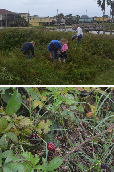
Figure 1. This family is picking wild dewberries growing near the coast on the bank of the old Brazos River channel in late April. Five hundred years ago, the natives of Follet's Island subsisted on berries like this every spring.
One of the native camps was close to the eastern tip of Follet's Island, near San Luis Pass, where a boatful of Narváez Expedition survivors led by Alonso del Castillo and Andrés Dorantes landed. The other camp was about a league and a half - or approximately five miles1 - to the west of there. The boat led by Cabeza de Vaca landed closer to it. Each group of natives befriended the Europeans who arrived closest to them. Within a few days, the two groups of Europeans learned about the other, and they combined.
The Capoques and the Han spent October through February on Follet's Island. Using sticks or hoes, they pulled roots that were "like truffles" from shallow channels. They also fished. The Joint Report states that they fished from their canoes, which probably means that they put the canoes in shallow water, stood, and shot arrows at fish that swam by. Despite having these two sources of food, the natives were always hungry. Come February, the roots could not be gathered, and the fish population dwindled, so the natives boarded their canoes and went over to the mainland, where many creeks drain into the bay, creating a reduced-salinity environment that is ideal for oysters. Apparently, the two tribes separated at this time. They lived and ate oysters for two or three months in these treeless, mosquito-infested swamps and lagoons. At the end of April, they came back to the seashore to eat blackberries for a month. The expedition chronicles do not say what the natives ate or where they lived from June to September, but the Joint Report states that they also ate "some very large spiders, as well as lizards, snakes, and rodents." The natives moved to a new food source every three or four days, and they planted no crops.
The texts' description of the natives' feeding grounds matches perfectly with the Follet's Island/Oyster Bay area, from the many shallow channels on the island to the adjacent mainland, speckled with brackish ponds, even down to the wild berries that grow on the coast in the late spring.
The expedition chronicles do not record any interactions between the Capoques and Han and any other tribes during the five years Cabeza de Vaca and his comrades spent with them, either for warfare, trade, intermarriage, or any other reason. The Joint Report states, "They neither eat corn nor are they able to obtain any," implying that trade with neighboring tribes was minimal or non-existent. This could mean that there was a degree of geographical isolation between them and their neighbors.
Of all the coast-dwelling tribes that the Europeans encountered in Texas, none were more benevolent and kindly disposed towards them than the Capoques and Han. When Europeans first arrived, the natives did not harm Cabeza de Vaca's scout, Lope de Oviedo, even though they caught him running away with a dog, some fish, and some pots he had taken from one of their huts. For the next few days, they brought food at regular intervals to the starving Europeans who were still camping on the beach. After the Europeans lost their boat and three men trying to leave the island, the natives wept over their loss and then joyously welcomed the castaways into their village with a celebration of dancing and bonfires. The Spaniards, aware that some of the natives of South America and Mexico made human sacrifices to their gods, laid awake all night, expecting that this would be their end, but when morning came, Cabeza de Vaca writes, "They gave us such good treatment that we became somewhat assured and lost some of our worry about sacrifices." 2 The Capoques and Han never laid a hand against the Europeans, but there was one close call: after a large number of natives died of illness, some of them blamed the Europeans and considered killing them, but others noted that the Europeans were just as much the victims of illness as they were, and so they were spared.
With as much hunger as there was on the Island of Misfortune, the European guests could not rely on the generosity of the natives forever. Healers enjoyed an elevated status in their culture, and the natives asked them to serve them in that office. The Europeans resisted, out of fear that the natives would be angry if their attempts to cure them did not work, but when the natives gave them the choice of either becoming their doctors or starving, they opted to give it a try. They performed very little actual medicine, instead operating primarily as faith healers, using rituals such as prayer, making the sign of the Cross, and breathing on the patient's affected area. Fortunately, their efforts fully satisfied the natives.
The Capoques and Han apparently did not engage in the practice of slavery, like many of their relatives down the coast did. Even though the natives did have a sort of "no work, no eat" rule, the Europeans were always free to either find their own food or leave. When the castaways decided to send four of their number down the coast in an effort to reach Mexico on foot, the natives sent one of their own with them as a guide. Over the winter, the castaways dispersed into several camps, some of whom apparently had no contact with the natives for months. And when spring arrived and a group of survivors were ready to leave, the natives helped them gather their people together and gave them some gifts or supplies for their journey. There is only one passage in the expedition chronicles that alludes to slavery among the Capoques and Han; this is when Cabeza de Vaca, who forsook the Island of Misfortune to live with the natives of Charruco on the mainland, stated that he "was not a slave" with the latter, implying by contrast that he was a slave with the Capoques and Han. This seems to be a bit of drama, however, considering that he was apparently free to visit his friend Lope de Ovideo on Malhado and then leave again any time he wished, and the reason Oviedo gave for not wanting to leave Malhado was that he feared the danger of the journey ahead, not because the natives were holding him captive. Cabeza de Vaca writes that he hated the root-pulling work he was given to do by the Capoques and Han; he apparently hated it so much he equated it with slavery, even though he was free to leave it, which he did.
"Our fear made them appear to be giants."
Comparisons With the Karankawa
The first time Cabeza de Vaca and his people saw the natives on the Island of Misfortune, the Europeans had just arrived after being adrift at sea for days and were weak, exhausted, and hungry. Hundreds of the native men appeared around them suddenly, with bows and arrows in hand. "Our fear made them appear to be giants,"3 Cabeza de Vaca wrote. He gave a more complete description of their appearance later:
We gave this island the name "Island of Misfortune." The people we saw there were large and well-formed. They have no other weapons than arrows and bows, with which they are extremely adept. The men have one nipple pierced from one side to the other; there are some who have both. They place a cane as long as two and a half hands and as thick as two fingers through the hole they make. They also have their lower lip pierced, and they put a piece of cane as thin as half a finger through it. The women do a lot of work.4
This physical description is consistent with later recorded descriptions of the Karankawa, as noted in the previous section, including their size, the men having cane piercings through their lip and nipples, and their use of bows and arrows. Discussing them further, Cabeza de Vaca relates their manner of dress: the men went nude, the women wore coverings of moss, and the girls wore deer skins. He also writes that when a child died, they mourned for a year and then washed off "all of the paint they wear,"5 confirming their use of body paint. He does not mention tattoos or grease. The only mention the Joint Report makes of their appearance is that their ears were pierced with pieces of cane.
Cabeza de Vaca's description of the appearance and customs of the Capoques and Han in Chapters 14 and 15 of La Relación was probably meant to extend to many of the other tribes on the coast, for he does not give a corresponding description of the others. Furthermore, there are places in Chapters 14 and 15 where Cabeza de Vaca explicitly states that he is referring to a broader population of natives, such as when he writes, "All of the people in this country go nude"6 and "This custom prevails from the island to more than fifty leagues inland."7
The "little puppy" that Lope de Oviedo found in one of the native camps comports with the common association between the Karankawa and dogs.
Even though Cabeza de Vaca's description of the Capoques and Han is an excellent fit with everything else that is known about the Karankawa, it is not completely clear-cut that this was, in fact, who they were. His statement, "Two manners of language inhabit them. The first are called Capoques, and the others Han,"8 suggests that at least one of them was from a different tribe. The most likely answer is that one of the clans was Atakapa, a tribe that was similar to the Karankawa, both in appearance and culture. The Atakapa inhabited the Gulf coast from southwest Louisiana to southeast Texas. The western extent of their range of occupation was Galveston Bay, which was also the eastern extent of the Karankawa. The Atakapa, whose name means "man-eater" in Choctaw, were also reported to be practitioners of ritual cannibalism. Texas historians have long identified Capoques with the Cocos or "Cokes," the easternmost Karankawa tribe of the 1700s and 1800s, whose habitat was from the Colorado River to Galveston Bay. This identification is compelling, not just because of the similarities in their territories and names, but also because, according to Harbert Davenport and Joseph K. Wells, whose work on Cabeza de Vaca in the early 1900s was more systematic and informed than any that preceded it, the Cocos were "the least barbarous of the Karankawan Indians" and were also on generally friendly terms with their Atakapa neighbors to the east. Historians associate the Han of the Island of Misfortune with the Akokisa clan of the Atakapa people.
The De Charruco
On the Texas mainland, adjacent to Follet's Island, where the Capoques and Han lived, were some woods where another group of natives lived. According to Cabeza de Vaca, the woods were called Charruco (ch. 16) or Chorruco (ch. 26). The only name he gave for the natives was "los de Charruco," or "those of Charruco." This article calls them the De Charruco.
Cabeza de Vaca is the only survivor of the Narváez Expedition who spent any significant amount of time with the De Charruco. He briefly recounts it in Chapter 16 of La Relación. In this chapter, Cabeza de Vaca explains why he did not leave the Island of Misfortune in April 1529 with Dorantes, Castillo, and the others, but instead waited another four years to leave. The chapter has a defensive tone to it and is filled with inconsistencies and clear inaccuracies, such as "The time I spent in this country alone among them was almost six years"9 and his implication that he was a slave on the Island of Malhado, against so much evidence to the contrary. He condenses his four years with the De Charruco into a few sentences, and these are more about drawing attention to himself than about describing the natives or the land. In other words, what little he does write about the De Churruco is suspect.
What Cabeza de Vaca does say about the De Charruco is that they did not assign him any hard labor, such as the root-pulling work that he hated so much on the Island of Misfortune, but instead gave him food in exchange for wares that that he obtained by becoming a roving trader. He traveled over a great distance inland and along the coast, bartering for shells, beads, hides, flints, dyes, and other items the natives wanted. This could mean that the De Charruco had contact with other tribes, and were not as geographically isolated as the Capoques and Han may have been.
The name Charruco has not been found outside of La Relación, and therefore is of no help in locating this territory. Woodlands and forests are found where fresh water is plentiful, such as around rivers and creeks, and in lowlands that are above the reach of saltwater tides. This means that the woods of Charruco could have begun just past the northern edge of Galveston's West Bay and extended inland an undefined distance. Cabeza de Vaca gives no indication of their location except that they were "on the mainland, facing the island"10. It would be unwise to form conclusions about where Charruco was based on something Cabeza de Vaca does not describe, but nevertheless, it is worth noting that, in all of La Relación, Cabeza de Vaca never mentions seeing the main part of Galveston Bay, which would have been the largest body of water he would have seen during his entire ten years in North America, save for the Gulf of Mexico. Based on what little information there is to work with, then, the middle and north sections of present-day Brazoria County, in the neighborhood of Bastrop Bayou, Oyster Creek, and the Brazos River, are as good a place for Charruco as any. The natives of Charruco may have been Karankawa, Tonkawa, Atakapa, or another tribe.
The Deaguanes
The Deaguanes are the first coast-dwelling tribe Cabeza de Vaca lists after the Island of Misfortune. He describes an encounter with them at the end of Chapter 16 of La Relación. He refers to them again in Chapter 24, recalling a previously unrelated incident with them. There, he refers to them as "los de Aguanes," or "those of Aguanes," indicating that, like the De Chorruco, the Deaguanes were named after the territory they inhabited. In Chapter 26, their name is spelled Doguenes.
In Chapter 16, Cabeza de Vaca and Lope de Ovideo left the Island of Misfortune, crossed "four rivers that were on the coast" - the Brazos River, the San Bernard River, Caney Creek, and possibly Bastrop Bayou or Oyster Creek - and came to an inlet that was "one league across" and "deep everywhere." Cabeza de Vaca took this inlet or pass to be the one that Spanish explorer Alonso de Pineda named "Espíritu Santo." (He was mistaken, for Pineda's Espritu Santo was the Mississippi River.) Its modern name is Cavallo Pass, and it is the natural inlet to Matagorda Bay (for further discussion, see our article, "Identifying the Inlet of Espíritu Santo"). Cavallo Pass separates the Matagorda Peninsula on the east side from Matagorda Island on the west. Some women of the Deaguanes helped Cabeza de Vaca and Oviedo across the pass. The natives on the west side of the pass, the Quevenes, frightened Oviedo so much that he opted to return with the Deaguanes. Cabeza de Vaca moved on, and Oviedo was never seen again.
Both La Relación and the Joint Report state that the Deaguanes and Quevenes were at war with each other at the time that the events in the chronicles took place. This is why the Deaguanes women helped Cabeza de Vaca and Lope de Oviedo across the pass; they were able to travel and visit other tribes even though the men were at war. Cabeza de Vaca writes that while he was with "those of Aguanes," their enemies came at midnight in a surprise attack, killing three. The Deaguanes retrieved all of the arrows that were used against them, followed the Quevenes back to their camp, and killed five in a pre-dawn strike. The women of the Quevenes then came and brokered peace with the Deaguanes, "although," Cabeza de Vaca added, "sometimes they are the cause of the war."11
Cabeza de Vaca does not state where he and Oviedo met up with the Deaguanes or how far they traveled with them before crossing Cavallo Pass. The Joint Report states that Dorantes's party encountered natives at the fourth river, which is taken to be Caney Creek, and Cabeza de Vaca does not name any tribes between the Island of Misfortune and the Deaguanes, so this may have been the tribe that Dorantes's party met. The natives of Caney Creek were eating blackberries, which grow on the coast in the spring. They assisted the Spaniards across the creek in a canoe and gave them a small amount of fish and a place to sleep for the night. The Spaniards traveled down the Matagorda Peninsula and made their own way across Cavallo Pass, using a damaged, discarded canoe. The Deaguanes' territory may have included all or part of the Matagorda Peninsula, although none of the various parties of survivors recorded any native contacts on it.
Due to their location on the coast, the Deaguanes were almost certainly a Karankawa clan. The chronicles do not record anything about their culture or territory other than what is stated above, and they say nothing about their appearance. They seem to have had a temperament similar to that of the Capoques and Han, for they assisted the Europeans willingly and did not seek to harm them or make slaves of them. Lope de Ovideo certainly considered them to be of a better temperament than the Quevenes.
Uninhabited Area
The section of Gulf Coast between Follet's Island and Caney Creek is where the mainland directly fronts the ocean, without there being any intervening bays or barrier islands. The expedition chronicles make no mention of natives living on the coast in this area, nor of the castaways having any contact with natives while traveling through it. As noted above, the Capoques and Han on Follet's Island seem to have been mostly isolated, and the only contact the Deaguanes are shown to have had with other tribes was with the Quevenes, to their west. This territory between the Capoques and Han and the Deaguanes, therefore, may have been uninhabited. It stands to reason that the coastal natives would have avoided this area, since the bays and the marshy north shores of the barrier islands, where they could wade and pull roots and fish from their canoes, were their principal sources of food, not the beaches or ocean. There may have been natives further inland who Cabeza de Vaca does not mention or identify.
The Mendica
According to Chapter 26 of La Relación, the Mendica lived on the mainland, adjacent to the Deaguanes. They are not mentioned anywhere else in either of the expedition chronicles. Since the Deaguanes apparently lived near the east end of Matagorda Bay, the Mendica probably lived in Matagorda, Jackson, and/or Wharton Counties.
"...they wanted to kill us like the others did our companions."
The Quevenes
The Quevenes inhabited the southern part of present-day Calhoun County. Cabeza de Vaca lists them as a coastal tribe, so they may have inhabited Matagorda Island, but the only contacts recorded with them in the expedition texts occurred on the mainland.
In November 1528, a group of about 80 Narváez Expedition survivors crossed Cavallo Pass in one boat that required multiple trips to get everyone over. The same night they crossed, the boat was lost, with Governor Narváez and two other men in it. The rest of the survivors - now castaways - went a little ways down Matagorda Island, but then decided to stop for the winter, as it was getting cold. Knowing they would need fresh water and firewood to survive, they made rafts and crossed over to the mainland. They stopped in some woods that went up to the edge of the water, which probably means they were at the mouth of a creek. Some of the Quevenes saw them, got in their canoes, and left. The Quevenes came back the next spring, on or around March 1, 1529, to see whether the foreigners were still alive. Only one of them, a Spaniard named Hernando de Esquivel, was. They took Esquivel as their slave.
Sometime soon after the Quevenes captured Esquivel, he had a chance to meet with another captured Spaniard named Figueroa. Cabeza de Vaca writes that Esquivel fled to another tribe, the Mariames, after the Quevenes captured him. Whether his meeting with Figueroa took place while he was with the Quevenes or the Mariames is unclear.12 Figueroa had been a member of the large group that landed on the Island of Misfortune, while Esquivel was the lone survivor of the group that had landed closer to Matagorda Bay. This was the only opportunity that members of the two main expedition parties had to exchange information about what had happened to each other, and it is thanks to this meeting that history knows anything about the fate of Governor Narváez, the commander of the expedition. Whether the Guaycones brought Figueroa to Esquivel specifically for this meeting is unknown, but it is entirely possible that the natives were anxious to find out from their captives how many more Europeans there were in their country, and where they were staying. Figueroa tried to persuade Esquivel to escape with him so that they could proceed together to the Spanish settlement at Pánuco, Mexico, but Esquivel refused because he believed they had already gone too far south, and that Pánuco was behind them, back up the coast. After their conversation was over, Esquivel "remained there, and Figueroa went to the coast where he had been previously."13
A little over a month later, Andrés Dorantes's party of nine survivors from the Island of Misfortune crossed Cavallo Pass and traveled down the coast of Matagorda Island without having any recorded contact with the Quevenes. They must have been on the mainland at this time. By this time, Esquivel had escaped from the Quevenes.
Cabeza de Vaca and Lope de Oviedo were the last members of the Narváez Expedition to cross Cavallo Pass. As explained above, the Quevenes were at war with the Deaguanes, who lived east of the pass. Since females could visit enemy tribes without hindrance, some Deaguanes women brought the two Spaniards across. Instead of continuing down the coast by way of Matagorda Island, however, they went over to the mainland. According to the Joint Report, they traveled another ten leagues after crossing Cavallo Pass, and according to La Relación, they traveled to within one league of a river that is usually taken to be the Guadalupe. It appears that they were on a course that would have taken them around the north end of San Antonio Bay. They stopped when they met the Quevenes.
By this time, which was the spring of 1533, much had happened. The Quevenes informed Cabeza de Vaca and Ovideo that Dorantes, Castillo, and Estevanico were being kept as slaves by a neighboring tribe, and were being abused and threatened with death daily. They also told them that five of their comrades had been killed. The Quevenes were not keeping any of the captives and were not a party to the killings, but it seems they were not too bothered by what had transpired. Cabeza de Vaca writes:
So that we could see what they had told us of the poor treatment of the others was true, while we were staying with them, they beat my companion and struck him with sticks. I also endured my share of it. They threw many balls of mud at us and held their arrows to our hearts every day, saying that they wanted to kill us like the others did our companions. 14
Despite receiving this bad treatment and hearing bad news about the others, Cabeza de Vaca wanted to find his comrades so that they could somehow escape together and resume their journey to Mexico. Oviedo wanted to do nothing of the sort. Cabeza de Vaca writes that he "contended greatly" with Oviedo and did everything he could to make him stay, but Oviedo chose to go back with the Deaguanes women, who had not yet started back home. Two days later, Cabeza de Vaca went to find Dorantes and the others, leaving the Quevenes.
The chronicles do not describe the Quevenes physically, nor do they relate any of their customs. The only information they give about their culture is the above treatment of the Europeans and a little about their war with the Deaguanes. They did practice slavery; Esquivel was their slave for a brief time, and Cabeza de Vaca states that he snuck away from the Quevenes, implying that he may not have been free to leave. Oviedo did apparently leave freely, but that may have been because the Deaguanes women, who brought the Spaniards to the Quevenes, were still there.
The Quevenes lived in the heart of Karankawa territory, and almost certainly were members of that tribe. They have been identified with the Cujane (Cojane, Kohani), a Karankawa group that inhabited the same general area in the 17th and 18th centuries. This identification is based entirely around the phonetic similarity of their names.
"I surely believe that if there were rocks in that country, they would eat them."
The Mariames
The Mariames are one of the main tribes in Cabeza de Vaca's narrative. Chapters 18 of La Relación is principally about them, and they are mentioned or alluded to in numerous other places. Their name is spelled "Mariames" in three places, while it is spelled "Mareames" twice. They were a mainland-dwelling tribe who lived adjacent to the Quevenes and were neighbors with the Iguaces.
The first known contact between the Mariames and any members of the Narváez Expedition happened in March or April 1529. Hernando de Esquivel was the only member of Governor Narváez's group of about eighty to survive the winter on the mainland across from Cavallo Pass. Esquivel was captured by the Quevenes, but after less than a month with them, he fled from them and became a captive of the Mariames. Cabeza de Vaca's wording, "he had fled...to others who were their neighbors, who were called the Mareames,"15 implies that Esquivel went to go live with the Mariames in hopes of improving his life.
The two groups who walked down the coast from the Island of Misfortune - Figueroa's group in November 1528 and Dorantes's group in April 1529 - crossed Cavallo Pass and continued walking down the coast, bypassing the Mariames' territory. Dorantes's group caught up with Figueroa. Figueroa told them he had met with Esquivel and that Esquivel had gone from the Quevenes to the Mariames since that meeting.
In August 1530, Andrés Dorantes, who had been captured and was at that time living as a slave of the Iguaces, fled to the Mariames. Like Esquivel, Dorantes believed or hoped that they would treat him better than his previous captors. When he got there, however, the Mariames told Dorantes that they had killed Esquivel within a month of his arrival because of one of the women dreamed he was going to kill her son. They showed Dorantes Esquivel's sword, rosary, book, and other belongings. Dorantes found out that the Mariames took such dreams very seriously, even killing their own children because of them. Consequently, Dorantes lived in constant fear of ending up like Esquivel. "Thus, when he was walking or when he was working digging roots," the Joint Report states, "he did not encounter an Indian that he did not think was coming to slay him because of some dream." The natives, knowing this, amused themselves by running up on him with a fierce expression and drawing their bows. "Were you frightened?" they would ask, laughing.16
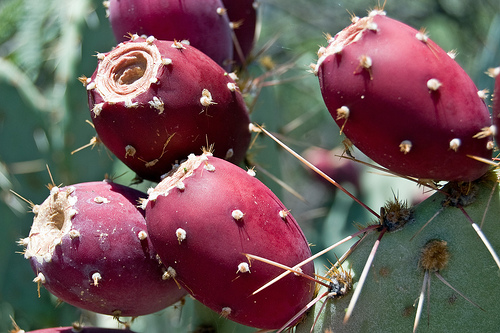
Cabeza de Vaca went to the land of the Mariames in 1533 to find Dorantes, Castillo, and Estevanico. The Quevenes told him that the natives who had his comrades would be coming soon to a river that was only a few miles away from them to eat nuts. There is broad agreement among Cabeza de Vaca route interpreters that the "river of nuts" was the Guadalupe, and the nuts were pecans. He went to the river of nuts and found his three comrades. Dorantes was being kept as a slave by the Mariames, while Castillo and Estevanico were being held by their neighbors, the Iguaces. These two tribes used some of the same feeding grounds, which gave the captive Europeans occasions to see each other. Cabeza de Vaca told his comrades he "intended to travel to a land of Christians."17 They warned him not to let the natives know that he wanted to leave and said their best chance to escape together would come in six months, when the Mariames and Iguaces went elsewhere to eat "tunas" - the fruit of the prickly pear cactus. Thus Cabeza de Vaca became a slave of the Mariames, along with Dorantes, and ended up staying with them for over a year.
Cabeza de Vaca writes that the Mariames were "well-built," but "not as large as those who we left behind," which is probably meant as a comparison with the natives of the Island of Misfortune. They were also archers. He tells us that four members of the household who kept Dorantes and him were tuertos, which literally means "one-eyed," but could also mean that they were cross-eyed or blind in one eye. He writes at length about Mariame culture, indicating that, in many ways, they were a callous and cruel people who, for example, fed their newborn daughters to the dogs, so that they would not grow up to wed their enemies and bear them children, thus helping their enemies multiply against them. The reason they had to worry about this was "because everyone in the land is their enemy, and they are continually at war with them."18 Their defense against mosquitos was not to smear themselves with oil or grease, but was to keep fires going of rotten, wet wood that produced a lot of smoke. Cabeza de Vaca and Dorantes were given much hard labor to do, and that included keeping the mosquito fires going at night. If they fell asleep and the fires went out, the Mariames would beat them awake with clubs.
The discussion Cabeza de Vaca had with the Quevenes about his comrades is written to make it sound as if the Mariames were responsible for many more cruelties towards the Europeans than the ones described above. The Joint Report, however, shows that the list of evil deeds committed by the natives in Cabeza de Vaca's account was the cumulative work of several tribes, including some who were even more savage than the Mariames. Cabeza de Vaca does not relate any specific acts of cruelty the Mariames perpetrated against him during his time with them, except for the clubbings he received from falling asleep while on mosquito duty, but he does condemn them generally for their "bad treatment" of him. He writes that he tried to escape from them three times. When they caught him, he always feared that they were going to kill him, "but our Lord God, in His mercy, willed to protect me and save me from them."19
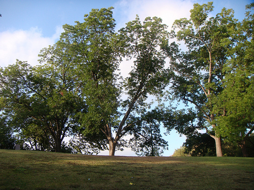
Figure 2. Pecan trees in Austin. The pecan was designated the official Texas state tree in 1906.
The texts explain the Mariames' migratory and feeding customs fairly well. Starting around October, they would eat pecans, which the texts call "walnuts" because pecans were unknown in Europe and walnuts were the most common nut grown in Spain. This was a feast or famine situation: sometimes there were enough pecans to last for two months without having to eat anything else, and sometimes there were none. When the nuts gave out, they turned to their principal sustenance, which was a kind of root that was hard to pull, took two days to cook, tasted bitter, and caused gas. "All winter," the Joint Report states, "they go along the river, from above to below, and from below to above and they never stop looking for food." The text says they caught mice "between those rivers," indicating that they lived where two or more rivers ran near each other. This confirms the location of the lower Guadalupe River, where the San Antonio River and several creeks converge into San Antonio Bay. In April, when the rivers flooded, the Mariames caught fish, but they had no salt or other way to preserve them, so most of their catch spoiled. In June, they would begin their journey to the prickly pear field, making a stop along the way to hunt deer by the sea. Occasionally, they killed several hundred, but "many other times, or even most of the time, they do not kill any."20 Campbell and Campbell theorized that the deer hunt took place at Copano Bay.
Even with these deer, fish, nuts, and roots, the texts explain, there was never enough food, and the natives were always hungry. Cabeza de Vaca writes:
...their hunger is so great, that they eat spiders, ant eggs, grubs, newts, salamanders, snakes, and vipers that kill the men that they bite. They eat earth, wood, and all that they are able to - deer dung, and other things that I am leaving out. I surely believe that if there were rocks in that country, they would eat them. They keep the bones of the fish that they eat, and of the snakes and other things, to grind all of them later and eat the powder.21
The one time of the year that the Mariames were not hungry was tuna season. Every year, after the deer hunt, the Mariames would travel, according to the Joint Report, "more than forty leagues," which is about 140 miles, to eat this dark red, egg-shaped, cactus fruit. This was not only the Mariames' time of most abundance, but it was also when they did their trade with and bought their wives from other tribes, as several others bands of natives came to the tuna fields, including their neighbors, the Iguaces. Tuna season lasted seven to nine weeks, and the Mariames looked forward to it all year, talking about how good it was going to be even when it was six months away. When tuna season was over, around early September, the Mariames would trek back to their home territory on the Guadalupe River and begin the pecan harvest, if there was one that year.
When Cabeza de Vaca arrived, Dorantes informed him that their opportunity to escape would be when the Mariames went for tunas. For one thing, the prickly pear field was 40 leagues "forward, in the direction of Pánuco," their destination. Furthermore, since the Iguaces would be there, so would Castillo and Estevanico. The three of them had already plotted an escape before, and they had an agreed meeting place, but they were not able to pull it off then. Perhaps this year, they would.
There is a discrepancy in the texts concerning when Cabeza de Vaca arrived at the Mariames and reunited with Dorantes. On one hand, Cabeza de Vaca states three times in La Relación (17:3, 18:10, 19:1) that he had to wait "six months" between his arrival at the Mariames and his chance to escape at the beginning of tuna season. This would have him arriving at the Guadalupe River around January, since tuna season started in July. On the other hand, when he met Dorantes, the Mariames had just returned to the Guadalupe River to begin the pecan harvest. La Relación states, "Two days after Lope de Ovideo had gone, the Indians who had Alonso del Castillo and Andrés Dorantes came to the same place that they [the Quevenes] had told us about to eat those nuts on which they subsist."22 The Joint Report states, "Each one [Dorantes, Castillo, and Estevanico] went his way with his master to eat those walnuts, and there were many of them that year. When they arrived at that place, Cabeza de Vaca came to join these others. It had been five years, since they had left him behind where they had lost the boats."23 This would have Cabeza de Vaca arriving at the river of nuts in September, after the tuna harvest. The problem of whether Cabeza de Vaca arrived six months before the tuna harvest or at the beginning of the pecan harvest has no easy solution. Route interpreters including Davenport and Wells, Krieger, and Varnum have not addressed it in their analyses. This article takes the view that Cabeza de Vaca arrived at the Mariames and met with Dorantes and the others in the late winter or early spring of 1533, perhaps early March, approximately five years after Dorantes and the others left the Island of Misfortune and six months before the end of the 1533 tuna harvest.24
The Mariames may have visited San Antonio Bay occasionally, but the texts make it clear that their main area of habitation was inland. For all of the many items in the Mariames' diet, the texts make no mention of the shellfish or wild berries that the coast-dwelling tribes ate, and the only time they had fish was when the rivers flooded. It appears, then, that their territory was in present-day Victoria County and/or at the north end of Calhoun County.
The identity of the Mariames is an open question. They have a few things in common with later descriptions of the Karankawa, such as having dogs and a habit of war, but on the whole, there is not enough in the record to reasonably conclude that they were a Karankawa tribe. Historians have tried to match them up with known tribes with similar sounding names, such as the Muruam, Mahuame, and Mariguan, but all of those tribes were from different areas of Texas or northern Mexico. Davenport and Wells match them with the Jaranames or Aranamas, a small band that lived in the lower Guadalupe River area in the early 1700s, but about which very little is known. Given their cultural practices of always being at war with everyone, killing their own newborn daughters as a rule and their sons when so inspired by dreams, and depending on their enemies for wives, perhaps we should not be surprised if they went extinct before settlers arrived 150 years later.
The Guaycones
According to the Joint Report, there was another small pass or inlet, about the width of a river, some twelve leagues further south of the large inlet that has to be Cavallo Pass. This inlet would be Cedar Bayou, which is the boundary between Matagorda Island and St. Joseph Island (or San Jose Island). Once the Narváez Expedition survivors reached Cedar Bayou, they encountered natives. Cabeza de Vaca, who we rely on for our information about the names of the tribes, did not come this far, and it can be hard to follow which tribes the Joint Report is referring to at many points. Based on the list of tribes Cabeza de Vaca gives in Chapter 26 of La Relación, however, the next tribe south of the Quevenes, and the one that inhabited St. Joseph Island, was the Guaycones.
According to the Joint Report, the Narváez Expedition survivors encountered two different groups of natives on present-day St. Joseph Island. The first group captured Figueroa and Méndez, two of the strong swimmers who left the Island of Misfortune in November 1528. The other two Spaniards and the native guide who were in their party died before reaching Cedar Bayou. These natives pursued and killed Méndez after he tried to escape from them.25 They still had Figueroa the following March, when they took him to the land of the Quevenes to meet with Hernando de Esquivel, the only survivor from Governor Narváez's party of survivors.26
In April, Andrés Dorantes and his party of nine castaways from the Island of Misfortune arrived at Cedar Bayou. The native who was holding Figueroa captive saw them across the inlet and brought him over to speak with them. After a while, the native was ready to leave. Exactly what was communicated to the Europeans is unclear, but Dorantes's party was famished and hoped to get some food from the native, and he was either unable or unwilling to bring them across the inlet, so the only two members of Dorantes's party who could swim went with the native and Figueroa while the rest remained on Matagorda Island. Once the native got to his village on St. Joseph Island with the three Spaniards, his people packed up their huts to go on a trip to pick leaves used to make "a special beverage." This is a reference to "blank drink," a beverage made from yaupon holly leaves that had ceremonial importance to native tribes from Texas to the Atlantic Ocean. One of the Spaniards, "a young boy who could swim," took a small amount of fish the natives have given him back to Dorantes's party on Matagorda Island. The other Spaniard, a holy man from the province of Asturias, stayed with Figueroa.
Of the two native bands that the castaways encountered on St. Joseph Island, this one, which held Figueroa captive and killed Méndez, appear to have been the main residents of the island, the Guaycones, while the other band, described subsequently in this article, appear to have been visitors from the mainland.
The band of natives that was visiting St. Joseph Island ended up capturing Andrés Dorantes and the seven men who were with him, but they didn't keep them long. These eight men then became separated into small groups and individuals, who went to various tribes. It appears that Andrés Dorantes, his cousin, Diego, and his slave, Estevanico, came back to St. Joseph Island and presumably found the Guaycones again. By that time, Figueroa and the Asturian holy man had gone ahead. Diego Dorantes stayed on St. Joseph Island while Andrés and Estevanico went on down the coast. Whichever band Diego ended up with, whether it was the Guaycones or another, he stayed with them for two years, and then they killed him for unknown reasons.
The name "Guaycones" is unknown outside of its sole appearance in Cabeza de Vaca's list of tribes in Chapter 26 of La Relación. While the natives of St. Joseph's Island must have been Karankawa, any connections between the Guaycones and one of the 18th or 19th-century Karankawa clans are unknown.
"On the next day he encountered some Indians who received him willingly, as they now knew that the Christians served well."
The Iguaces
The Iguaces were a tribe on the mainland. They had some affiliations with the Mariames, who were their neighbors to the east. Their name appears four times in La Relación: in Cabeza de Vaca's list of tribes in Chapter 26, and three times in Chapters 17 and 18, as part of his discussions of the Mariames.
The Iguaces did not enter the story of the Narváez Expedition until about a year and a half after the boats landed on the Texas coast. After spending a year as a captive of two other tribes, in May 1530, Andrés Dorantes decided to try to escape. "That day," the Joint Report states, "he passed a large body of water, and in great fear he walked as far as he could. On the next day he encountered some Indians who received him willingly, as they now knew that the Christians served well."27 Three months later, Estevanico went after him. He found Dorantes with the Iguaces, but Dorantes did not stay long; that same month, Dorantes fled once again, this time to the Mariames, "as he was not able to endure those Indians [Iguaces] who were very unjust." Alonso del Castillo joined Estevanico around February of 1531. Castillo and Estevanico thus remained with the Iguaces, while Dorantes was with their neighbors.
The texts tell us very little about the Iguaces except to point out a few similarities they had with the Mariames. The custom the Mariames had of feeding their newborn daughters to the dogs and buying wives from their enemies was one of them. Cabeza de Vaca writes, "Only they [the Mariames] and the others, their neighbors who are called the Iguaces, follow this custom; no one else in their land keeps it." The Iguaces went to the prickly pear field at the same time as the Mariames and also ate pecans at the river of nuts with them. The texts show that whenever the Iguaces and Mariames were near each other, they did not intermingle, but kept a respectful distance apart and did their business with each other through representatives. Castillo, Estevanico, and Dorantes knew that they might be able to see each other at such times, but then again, they might not. The Joint Report states that they had planned to escape together during the tuna harvest of 1532, but "the Indians were never calm or together," so the three Europeans could not meet. A year later, after Cabeza de Vaca had joined the group, they all got together and were about to make their escape when the Mariames and Iguaces got into an argument over a woman, a fistfight broke out, and the two tribes parted ways. The Iguaces and Mariames were still at war with each other a year later, but fortunately for the Europeans, they made peace with each other in the tuna fields, and the four ragged castaways were able to make their escape.
Starting from Mustang Island in Nueces County, Dorantes walked for parts of two days, passing "a large body of water" to reach the Iguaces. The body of water would have been Copano Bay. The territory of the Iguaces was apparently in present-day Refugio County.
Davenport and Wells identify the Iguaces with the Anaquas, a Tonkawa group named for the anaqua trees common to south Texas. Like many of the other tribal identifications in this article, this one is not based on any known historical connection to them, but on geographic agreement and a similarity in their names - the former more so than the latter, in this case.
The Atayos and Acubadaos
Cabeza de Vaca's list of tribes in Chapter 26 of La Relación follows a pattern at first, wherein he names a coast-dwelling tribe - or tribes, in the case of the Capoques and Han - and then names a tribe that lived "facing" them on the mainland. When he gets to the Guaycones and Iguaces, the pattern changes somewhat: he names two more tribes, the Atayos and Acubadaos, before naming the next coastal tribe. His exact wording is as follows:
Going further along the coast are others who are called Guaycones, and facing them, within the mainland, the Iguaces. At the end of these are others who are called Atayos, and in back of these, others, Acubadaos. There are many on the path ahead of these. Others called Quitoles live on the coast..."28
The reason why more mainland tribes would be named is obvious: the Gulf coast curves inward. There is more room for tribes to live on the mainland than on the coastline, just like there is more room for pepperoni near the outer edge of a pizza than there is near the center. In particular, the area where the Guaycones were, St. Joseph's Island in Aransas County, is at the so-called "coastal bend," where the coast turns a little more sharply than in other places. Our analysis indicating that the Guaycones, Iguaces, and Atayos were located at the coastal bend is supported by the fact Cabeza de Vaca changed his formula when he got to their names.
Cabeza de Vaca states that the Iguaces "faced" the Guaycones, and at the "end" (cabo) of them were the Atayos. Cabo is a word Cabeza de Vaca frequently uses to mean "finished" or "completed." In other words, where the Iguaces' territory ended, the Atayos' began, and then detrás de, or "in back of" the Atayos were the Acubadaos. This means that both the Iguaces and the Atayos faced the Guaycones - first, going from northeast to southwest, the Iguaces, then the Atayos. The Acubadaos were further inland from the Atayos.
The Iguaces, as noted above, were, from the perspective of Mustang Island, beyond the "large body of water" that is now called Copano Bay, putting them mainly in the northeastern half of present-day Refugio County, and possibly into Victoria and Goliad Counties. The Atayos, then, were probably in the southwestern half of Refugio County and/or San Patricio County, on the near side of Copano Bay. The Acubadaos could have been in the general vicinity of Bee County.
The Joint Report states that when Dorantes's party of eight was stuck on the west end of Matagorda Island, trying to cross Cedar Bayou, a group of natives who were different from those who had Figueroa captive came in canoes to pick berries on the coast. The Spaniards called to them. They came over "as if they were coming to people they respected little."29 They "almost forcefully took part of what they had" and agreed to take them across the inlet. Dorantes and his seven companions spent two nights with these natives, who kept them supplied with fish. The natives then moved to a different area and took the Spaniards with them. At this point, they knew that they would probably not see Figueroa or the Asturian holy man again. Before long, these natives threw five of their guests out because they were "tired of giving them food."30 They kept three - Andrés Dorantes, Diego Dorantes, and Estevanico - to work for them for three or four days, then threw them out, too. All of this occurred in the vicinity of St. Joseph Island and Copano Bay.
Who were these disrespectful natives? They did not harm the Europeans, and did give them aid, although they seem to have lacked a charitable nature. They had no real interest in keeping the Europeans as slaves - they may have tried it out, then decided against it. Based on subsequent events, we know they were not the Iguaces, and we have seen that they must not have been the Guaycones. The Quevenes cannot be ruled out, although the area these events took place would have been a long way for them to come to pick berries, when there were undoubtedly many berries much closer to them. The Atayos are the only other tribe mentioned by Cabeza de Vaca as inhabiting this area, so perhaps it was them.
Cabeza de Vaca mentions the Atayos one more time, after he, Dorantes, Castillo, and Estevanico fled from the Iguaces and Mariames, but while they were still within a few days' walk of the coast. All he says about them is that they were at war with the Susolas. The Atayos have been associated, geographically and phonetically, with either the Toho or the Tohaha, two different 18th-century tribes that occupied the same general vicinity as the Atayos.
The Acubadaos are completely unknown and are not mentioned anywhere in history outside of their name being in Cabeza de Vaca's list of 19 tribes.
"If it had been in their power, it would have been better to find death alone in the countryside, and not to live among such bestial and bad people."
The Quitoles
The Quitoles are another tribe who are only mentioned by name once in Cabeza de Vaca's La Relación and whose role in the Narváez Expedition is presumed based upon their apparent location. That role, however, may have been substantial.
Some natives visiting St. Joseph Island to pick berries in April 1529 picked up Andrés Dorantes and his seven companions and begrudgingly took care of them, but after a while, they decided they were feeding too many foreigners and threw five of them out. These natives told the Spaniards that they could go to some other natives who were located on an inlet six leagues down the coast from them. This inlet was probably Aransas Pass, so it appears that the natives were sending the Spaniards to Mustang Island in present day Nueces County. According to our interpretation of Cabeza de Vaca's list of tribes, this was where the Quitoles lived.
The five Spaniards who were released probably considered themselves fortunate. They had seen their countryman, Figueroa, being held captive by the Guaycones, they had heard of heard of another countryman, Hernando de Esquivel, being held captive by the Quevenes, and they had just left three more behind as captives of another tribe. These five were now free, however, to continue their journey down the coast to Pánuco. Once they arrived, they would send help back for all the others. Before they got very far, however, two of these five died of hunger, and the other three were captured by the Quitoles. It is debatable which group was more fortunate.
The Quitoles took Alonso del Castillo, Pedro de Valdivieso, and Diego de Huelva captive. While Valdivieso was on Mustang Island, he saw Figueroa and the Asturian holy man. The natives beat them on the head and stripped them of their clothing and belongings because they wanted to leave. Cabeza de Vaca writes that the Asturian ended up with an arrow wound going all the way through his arm. Nevertheless, these two men fled, determined to continue on to Pánuco. A short time later, the Quitoles killed both Valdivieso and Huelva. The Joint Report states that Valdivieso was killed "because he wanted to leave" and Huelva "because he changed from one lodging to another."31 Throughout the expedition chronicles, Castillo is depicted as the most cautious of the castaways and the one with the greatest tolerance for hardship. This passive nature may have been the only reason he remained alive.
By summer, Andrés Dorantes and Estevanico had joined Castillo on Mustang Island. The three of them stayed there together for almost a year, carrying water on their backs for their masters. The texts state that these people treated the Europeans more cruelly than any other natives on the coast. The children, who may have never seen men with beards before, enjoyed sneaking up on the Spaniards and jerking on their beards. "This gave them the greatest laughter and pleasure in the world." The children also scratched the Europeans with their long, knife-like fingernails, often drawing blood. The boys threw rocks at them, treating them as if they were game in a hunt. "If it had been in their power," the Joint Report states, "it would have been better to find death alone in the countryside, and not to live among such bestial and bad people."
"They were enclosed by water," the text states, "as there were islands all around where they were." The Quitoles apparently did not travel inland, for their diet consisted entirely of fish all year round, and they had very little fresh water. This description comports with the northeast end of Mustang Island, at Aransas Pass.
The three surviving Spaniards escaped from the Quitoles one by one. Dorantes was the first to leave, in May 1530. He walked for part of a day and passed a large bay, which would have been present-day Copano Bay, then walked for part of another day to end up with the Iguaces. Estevanico went after him in August 1530, and then Castillo finally left in around February 1531.
The Quitoles have not been identified with any known 18th-century native tribe.
The Avavares, Maliacones, Cutalchiches, Susolas, and Comos
Cabeza de Vaca names five tribes as living on the mainland across from the Quitoles: the Avavares, Maliacones, Cutalchiches, Susolas, and Comos. His list of "nations and languages" in Chapter 26 does not attempt to describe the positions of their territories with respect to each other. According to our analysis, the Quitoles lived on Mustang Island outside Corpus Christi Bay. This would place these five tribes around Corpus Christi Bay and the Nueces River.
The four ragged castaways - Cabeza de Vaca, Dorantes, Castillo, and Estevanico - escaped from the Mariames and Iguaces while those tribes were in a large prickly pear field for the annual tuna harvest. There were a number of other tribes in the prickly pear field at the same time. Dorantes, Castillo, and Estevanico first escaped to an otherwise unknown tribe named the Anagados. Castillo stayed with them while Dorantes and Estevanico went back to find Cabeza de Vaca. They found him, then the three of them waited for a chance to escape again to the Anagados. Once they did, and all four men were together, they ran for an entire day towards some smoke they had seen beyond the prickly pears. Thus they arrived to stay with the Avavares.
The texts imply that the Avavares lived near the prickly pears and had already finished their harvest for that year, as the four ragged castaways made their escape as the last of the tunas were being picked.
Cabeza de Vaca estimated that the prickly pear field was thirty leagues from the river of nuts, meaning it was about 100 miles from the lower Guadalupe River. The Joint Report puts the estimate as forty leagues, or 140 miles, but the Joint Report was apparently starting from the "salt water" of San Antonio Bay.32 Cabeza de Vaca also noted that the region of the prickly pears had "many large and beautiful meadows, with very good pastures for cattle"33 and had no mountains. Cabeza de Vaca route interpreters agree about the general vicinity of the prickly pear field, but not the specific location. Davenport and Wells, who published their analysis in 1918, used the testimony of still-living settlers who remembered what south Texas looked like before the cattle drives and the advent of barbed wire. Davenport and Wells believed the land must have looked to those witnesses just like it looked in Cabeza de Vaca's day. They placed the prickly pear field in southeast Duval County. Alex D. Krieger believed that the prickly pear field had to have been east (or north) of the Nueces River, and therefore placed it in south Atascosa County, but he recognized that the Avavares had to be further south and closer to the coast than this, so he put them and a "second tuna field" in north Duval County. Campbell and Campbell, who published a study in 1981, placed the prickly pear field near Alice in Jim Wells County and the homeland of the Avavares southwest of there. In conclusion, although researchers are still trying to find the best place for the prickly pear field, a consensus has been reached that the Avavares lived west of present-day Corpus Christi.
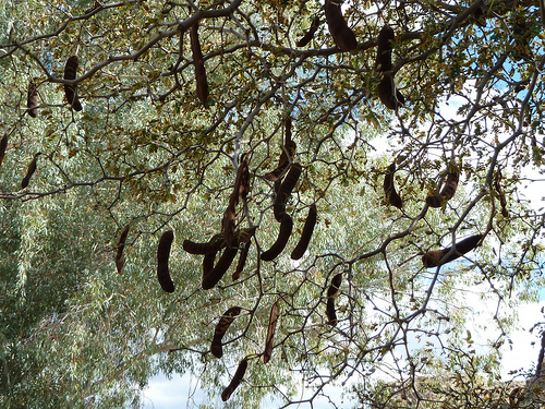
Figure 4. Seed pods growing on a Texas ebony tree.
The Avavares, Cabeza de Vaca writes, were "much more hungry" than even the Mariames, because they did not have access to fish, pecans, or acorns. A few days after the Europeans arrived, the Avavares took them on a trip lasting five days to another camp that was on a river. Here, they ate a pea-like fruit that grew on trees. This area was extremely dense with trees and brush and was difficult to walk through. Davenport and Wells identify the food as the ebony seed (mahuacata) and the location as north Hidalgo County.
The Avavares treated the castaways well. The Europeans were expected to dig their own food and carry their own water and firewood, but they were not forced to work for the natives. The Avavares believed the Europeans were "children of the Sun" and possessed supernatural powers. They brought their sick to Castillo, asking him to heal them. Castillo performed the same cures he had done on the Island of Malhado - praying, making the sign of the Cross, and breathing on the patient - with the natives, once again, being completely satisfied with the results. They paid him with bows, arrows, and tunas. The Europeans remained with the Avavares for eight months, and during this time, natives from many other tribes came to visit them to be cured by the children of the Sun. The number of natives seeking healing became too many for Castillo to handle alone, so Cabeza de Vaca began performing cures also. Eventually, Dorantes and Estevanico also became doctors.
The four ragged castaways departed from the Avavares to their neighbors, the Maliacones, near the beginning of the tuna season of 1535. The Avavares would have been back at their home near the prickly pear field which was, as explained above, west of Corpus Christi, probably in either Jim Wells or Duval County. The Maliacones or Malicones were, according to Chapter 22 of La Relación, "further ahead" relative to the Avavares, and "a day's journey" distance-wise. This would put them some 20 to 30 miles roughly south-southwest of the Avavares. The Europeans had already met the Maliacones when the latter brought some of their sick to the Europeans at the Avavares camp to be healed.
Cabeza de Vaca writes that they left the Avavares "without them being aware." One wonders whether the Europeans anticipated that the Avavares would make a fuss and create a drawn-out scene if they expressed a desire to leave, and they wanted to avoid that, or whether they retained some fear that these natives, too, might try to hold them against their will. The Avavares did follow and catch up to the Europeans at the Maliacones' camp and "showed grief" when they said they were moving on, but they left without trying to stop them.
The Maliacones are the last of the 19 tribes named in Chapter 26 of La Relación with whom the four ragged castaways stayed. After leaving them, the castaways stayed with tribes whose names Cabeza de Vaca either did not include in the list given in Chapter 26, or did not record at all.
The Cutalchiches are named twice in Chapter 22 of La Relación. Their name is spelled once the same way as in Chapter 26, but the other time, it is spelled Cutalches. They had also visited the Avavares to see the Europeans and be healed by them. Cabeza de Vaca writes that the Cutalchiches gave the Europeans tunas for their healing work, and "they also gave us flints as large as a palm and a half."34
Cabeza de Vaca writes that the Maliacones and Cutalchiches "are other languages," presumably meaning they each spoke a different language than the Avavares, who, he also notes, spoke a different language than the Mariames. It would be interesting to know which, if any, of these 19 tribes spoke the same language, but alas, Cabeza de Vaca never tells us that.
The brief discussion of the Susolas in Chapter 22 of La Relación gives substantial information to help locate them. Cabeza de Vaca states that they were at war with the Atayos, and these two tribes "exchanged arrow shots every day."35 These two tribes, therefore, were obviously neighbors. Our analysis places the Atayos west of Copano Bay, so the Susolas must have been north or northeast of Corpus Christi Bay. Cabeza de Vaca also writes that the Susolas came to visit the four ragged castaways during their eight-month stay with the Avavares and that they liked Cabeza de Vaca and remembered "that I had cured them at the nut groves."36 This indicates that they, unlike the Avavares, joined in the pecan harvest on the lower Guadalupe River in late autumn. Cabeza de Vaca, Dorantes, and Estevanico went to the Susola village to cure a native who was near unto death. They did not stay the night, but returned to the Avavares. This means that the Susolas were within a half-day walk from the Avavares' main camp west of Corpus Christi. Considering all of this information, the Susolas must have lived near the Nueces River in either Jim Wells, Nueces, or San Patricio Counties.
The Comos are only mentioned in the list of nations and languages in Chapter 26 of La Relación, unless they are also the "Coayos" mentioned in Chapter 22. Davenport and Wells write that an 18th-century tribe that the Spaniards called "como se llama," which means "what they are called," was "quite possibly" the remnant of the Comos and Coayos.
"They showed us some of their clothing and weapons and told us that the boat was there, on its side."
The Camoles
According to Cabeza de Vaca's list of nations and languages in Chapter 26 of La Relación, the Camoles lived down the coast from the Quitoles. According to our analysis, the Quitoles lived on Mustang Island, at the head of Corpus Christi Bay in Nueces County. This would place the Camoles in the area of Padre Island and Baffin Bay in Kleberg and Kenedy Counties.
The Camoles are also mentioned once in Chapter 19, where they are called Camones. None of the four survivors who made it out of Texas had any contact with them, but some less fortunate members of the Narváez Expedition did. While the four survivors were staying with the Avavares west of Corpus Christi, they finally received word about the fifth boat that was part of the expedition:
Those Indians told us that there were others further, called Camones, who live toward the coast, and who had killed all of the people who came in Peñalosa and Téllez's boat. They were so weak, that although they were being killed, they could not defend themselves, and so they finished them off. They showed us some of their clothing and weapons and told us that the boat was there, on its side.37
If the Avavares lived in or around Jim Wells County, as researchers have theorized, they would have been a two-day walk from the coast in the area of Baffin Bay. They would have had opportunities to trade goods and information with the Camoles, as the passage quoted above states that they did.
The news of what had happened to the men on the fifth boat, combined with the other bad experiences the European castaways had with the tribes that lived on the coast, convinced them to follow a more inland route toward Pánuco.
The Camoles' area of habitation and record of violence is sufficient for most historians to assume them to be Karankawa.
The De Los Higos
The last tribe mentioned in Cabeza de Vaca's list of nations and languages in Chapter 26 of La Relación is the De Los Higos, which means "of the figs." This tribe lived down the coast from the Camoles, who, according to our analysis, lived in the vicinity of Baffin Bay, probably on Padre Island and perhaps also on the adjoining coast of the mainland. There are numerous places along Padre Island and the Laguna Madre, the elongated bay that separates Padre Island from the mainland, where the De Los Higos could have lived, such as coastal Kenedy County, but their name hints that they may have lived as far south as Mexico, where the ficus maxima, a species of fig tree, grows. It is also quite possible that the name of the tribe simply sounded to the Spanish ear like "higos" or "de los higos," and actually had nothing to do with figs.
While Cabeza de Vaca and his comrades were staying with the Avavares, they told them that two of their fellow Spaniards, Figueroa and the Asturian holy man, had made it as far as the De Los Higos and were staying with them. The Europeans had last seen those two men with the Guaycones, so they successfully avoided or escaped from both the Quitoles and the Camoles, the two most dangerous tribes in the region. The text does not say whether Figueroa and the Asturian were being held captive by the De Los Higos or were simply lodging with them for a while, and they are not mentioned again. It is unlikely that they settled down to live with the De Los Higos for the long term; these two men seemed to be especially determined to either reach Pánuco or die trying. They did not reach Pánuco.
As discussed above, the Avavares probably ranged from present-day Jim Wells County to north Hidalgo County, so their having knowledge of the De Los Higos matches our theory that the latter tribe lived somewhere south of Baffin Bay, anywhere from Kenedy County to Mexico.
Using the information learned from the above analysis, Figure 5, below, places the nineteen tribes named in Chapter 26 of La Relación on a map of the Texas coast.
The reader is reminded that all of these tribes were migratory, and some traveled quite far from "home" at certain times of the year. None of them had "official" boundaries, that we know of. All of these conclusions, as well as those anyone else makes, should be considered approximations and best estimates. That being said, a thorough, detailed analysis of the information the expedition chronicles provides about the tribes allows us to locate most of them with a high degree of confidence.
Figure 5. Native Peoples of Coastal Texas Mentioned by Cabeza de Vaca.
The locations of five of the tribes are beyond serious dispute:
The Capoques & Han lived on the Isla de Malhado, or "Island of Misfortune," and on the adjoining coastal wetlands. The texts' detailed descriptions of the island's dimensions, terrain, flora, and fauna are a near-perfect description of present-day Follet's Island/San Luis Peninsula and Oyster Bay/Christmas Bay in present-day Brazoria County.
The Quevenes lived west of the great inlet that the Spaniards called Espíritu Santo, now known as Cavallo Pass. They were known to inhabit the coast of mainland Calhoun County and are presumed to also have inhabited Matagorda Island.
The Mariames lived inland from the Quevenes on the lower Guadalupe River in Victoria and/or north Calhoun County.
The Avavares lived approximately 30 or 40 leagues from the Mariames, in the direction of Mexico, not on the coast, but not too far from it, near a large prickly pear field many tribes visited every year. Their home was west of Corpus Christi Bay in either Jim Wells or Duval County.
The next eight tribes can be located reasonably well based on the information given about them combined with the locations of the five tribes listed above:
The Deaguanes lived on the coast between the Capoques and Han and the Quevenes. The castaways reported no native sightings between Follet's Island and Caney Creek, so Deaguanes territory may have started at Caney Creek and extended down East Matagorda Bay, taking in some or all of the Matagorda Peninsula. All of this territory is in Matagorda County.
The Guaycones lived down the coast from the Quevenes. The castaways encountered two tribes on the east end of St. Joseph Island in Aransas County, one of which was only visiting the area to pick berries, while the other seemed to be its main residents. The latter tribe is assumed to be the Guaycones.
The Iguaces lived west of the Mariames, inland from the Guaycones, and a day's walk beyond a large body of water. This puts them in Refugio County and possibly parts of Goliad and Victoria Counties.
The Atayos lived inland from the Guaycones and were neighbors with the Iguaces. These may have been the natives who came to pick berries on St. Joseph Island. Their home was in the general vicinity of Bee, San Patricio, Refugio, and Live Oak Counties.
The Quitoles lived down the coast from the Guaycones and adjacent to the Avavares. They correspond to the tribe that lived on an island surrounded by water six leagues from St. Joseph Island. This would be Mustang Island in Aransas County.
The Susolas lived less than a half-day's walk from the Avavares. They battled daily with the Atayos. They must have lived in north Jim Wells County, west Nueces County, and/or west San Patricio County.
The Maliacones lived a full day's walk south or southwest from the Avavares. This could put them in Jim Wells, Duval, Kleberg, Kenedy, Brooks, and/or Jim Hogg County.
The Camoles lived down the coast from the Quitoles. The Avavares apparently had direct contact with them. They most likely lived at the north end of Padre Island in Kleberg and/or Kenedy County.
The texts give very little information about the last six tribes, except for their positions relative to other tribes:
The De Charruco lived inland from the Capoques and Han, but did not have any recorded contacts with them.
The Mendica lived inland from the Deaguanes.
The Acubadaos lived inland from the Guaycones, "in back of" the Atayos.
The Comos lived inland from the Quitoles and near the Avavares. If they were the same tribe that is elsewhere called the Coayos, they may have lived with, or near, the Susolas.
The Cutalchiches lived inland from the Quitoles and near the Avavares. They may have lived with, or near, the Maliacones.
The De los Higos lived down the coast from the Camoles. The Avavares had contact with them, but whether this was direct or indirect is unclear.
By David Carson Page last updated: April 11, 2021
1The Spanish common league equals 3.46 miles. It represented the distance a person could walk in an hour.
12Chapter 17, Paragraph 6 of La Relación describes Esquivel as "a Christian staying with the Mariames," who had been found by the Quevenes. In Chapter 18, Paragraph 1, however, Figueroa tells other castaways that Esquivel "had fled from that Indian with whom he was staying to others...who were called the Mareames."
24One approach would be to say that Cabeza de Vaca wrote "six months" in error three times, and should have instead written "ten months." This, however, throws off the whole timetable of the narrative. It is beyond dispute that the four ragged castaways escaped from the Mariames and Iguaces at the end of the tuna season of 1534. It is also beyond dispute that the escape was made during Cabeza de Vaca's second tuna season since joining the other three. If he arrived at the river of nuts in September 1532, when the Mariames and Iguaces were returning from the tuna harvest and beginning the pecan harvest, then the above statement that Dorantes had not seen Cabeza de Vaca for "five years" is wrong, as are many other statements made in both of the expedition chronicles about the time that Cabeza de Vaca spent at Galveston Bay. Though I don't like doing so, I must surmise that the chronicles are wrong about Cabeza arriving just as pecan season was beginning. Perhaps the Mariames and Iguaces were returning together from another minor expedition together, and the information about where they were coming from and what they were going to eat upon their return became confused.
25Cabeza de Vaca gives this account of Méndez's death in La Relación 17:6. In 16:8, he writes that the Mariames "killed Esquivel and Méndez because of a dream," but this is clearly an error.
26While it is hard to keep the tribes straight at this point, it seems safe to say that the Quevenes are excluded from being the tribe that held Figueroa captive, since they are the ones who were keeping Esquivel at the time he and Figueroa were brought together to meet.
27The Joint Report has a mistake, in that it attributes Dorantes's flight to the Iguaces as occurring both in May 1530 and "in the middle of the month of August." The sudden switch from May to August is unexplained and makes no sense at that point in the narrative. A few sentences down, however, is a statement that Estevanico went after Dorantes "after three months." It appears that the phrase about August, which comes three months after May, was meant to go there instead of where it was put.
Cabeza de Vaca, Alvar Nuñez - La Relación. Translated to English by David Carson, 2016
"The Joint Report Recorded by Gonzalo Fernandez de Oviedo y Valdes," translated to English by Gerald Theisen, published in The Narrative of Alvar Nunez Cabeza de Vaca by The Imprint Society, 1972
Davenport and Wells - "The First Europeans in Texas, 1528-1536" in Southwestern Historical Quarterly, Volume 22, July 1918 - April 1919