
Identifying the Isla de Malhado
Identifying the Isla de Malhado
Introduction
On November 5 and 6, 1528, about eighty survivors of the Narváez Expedition to Florida landed on an island on the upper Gulf coast of Texas. These castaways were the first non-indigenous people to set foot on Texas soil and were the first people to commit a description of Texas to writing. Accidents, starvation, and exposure took a heavy toll on the group, which dwindled down to less than twenty during the first winter. Alvar Nuñez Cabeza de Vaca, one of the survivors, wrote, "We gave this island the name, 'Isla de Malhado'": Island of Misfortune.
The Isla de Malhado is one of the main settings in Cabeza de Vaca's account of the expedition. Six of the 38 chapters of his narrative, which is entitled La Relación, take place on this island or in its vicinity, and over four years passed between the time the castaways landed there and when the last one left. Both Cabeza de Vaca's account and the other record of the expedition, the Joint Report, describe the island's topography and terrain and its plant and animal life. La Relación goes even further, leaving a record of the appearance and customs of the native tribes who helped the castaways survive there.
In addition to Malhado's importance to the story, it is also important to interpreting Cabeza de Vaca's route across Texas. His journey through Texas began here, and it is one of the most-documented places in the expedition records, so if we cannot determine where the Isla de Malhado was, how can we interpret the rest of his route? Fortunately, we can.

Order your copy of The Account of Cabeza de Vaca: A Literal Translation with Analysis and Commentary, translated by David Carson of TexasCounties.net, available in E-book and paperback formats.
The Geography and Natives of Galveston Bay
Before we analyze the source texts in detail to see what they have to say about the Island of Misfortune, let us take a general overview of what we know happened to the members of the Narváez Expedition. They launched five boats from the northern coast of Florida with the intention of skimming the shore westward to Mexico. They did skim the shore for several days, stopping on the coast as needed to make camp and collect drinking water. When they tried to cross a river with a strong current, they were driven out into the deep waters of the Gulf of Mexico. They spent several days lost at sea and became separated. Two of the boats washed up on the Island of Misfortune - a place that was separated from the mainland by bays. Over a period of years, the survivors from these two boats left the island in three different groups. Each group followed the coast and, after crossing four rivers, came to a series of bays, including some very large ones. After spending a few years near this second group of bays, four survivors began traveling again, but now avoiding the coast and going through a semiarid region characterized by mesquite trees and cacti. After crossing a very broad, deep river and seeing mountains for the first time on the journey, they turned to the west. They eventually ended up on the western coast of the Mexican mainland, on the Gulf of California.
Anyone with a working knowledge of the geography of North America and/or access to a decent map can determine the basic elements of this route: the large river that drove the boats into the Gulf was the Mississippi, the Island of Misfortune was at Galveston Bay, the second set of bays began at Matagorda Bay, and the large river in the middle of the drier land, where the mountains began, was the Rio Grande. This basic route seems to be so self-evident as to not require debate. The various alternate theories that have been advanced always feature impossible geography, such as prickly pears in Arkansas or mountain ranges in north Texas, and are easy to shoot down. And, while some historians or researchers actually have disputed the identification of the Mississippi River or the Rio Grande in this interpretation, no one has ever advanced a plausible theory that the Island of Misfortune was anywhere other than at Galveston Bay on the Texas Gulf coast.
Let us now review some information the texts give about the Island of Misfortune, in order to find out what kind of place it was. Per La Relación and the Joint Report, it was an island with a sandy beach and at least one climbable tree. This island was seasonally inhabited, specifically in late autumn and winter, when the fish were more plentiful, by two neighboring native tribes who spoke different languages. Cabeza de Vaca called the tribes the Capoques and the Han. These natives did not farm, but subsisted chiefly on fish and roots, both of which were collected from shallow channels. The natives were "large and well-formed" and painted their bodies. The men went nude and wore cane piercings in their ears, nipples, and lower lips. The natives on the mainland side of the bay ate oysters in the winter, blackberries in the spring, and subsisted the rest of the time on roots spiders, lizards, and rodents. They slept on hides collected from the few deer that they hunted. There was a scarcity of firewood on the mainland, the water was brackish, and the mosquitos were, in a word, "unbearable."
This description of the land and its people confirms the Galveston Bay location. Two different tribes once inhabited the upper Texas coast - the Karankawa and the Atakapa. Both of these groups were known to be nomadic fisher-gatherers who lived on the coast during the winter and moved inland in the summer, when the fish migrated back out to deeper water. Both groups were painted and pierced. The Karankawa inhabited the coast from Corpus Christi Bay to Galveston Bay, while the Atakapa ranged from Galveston Bay to southwest Louisiana. Galveston Bay is the only place that they both inhabited, so the fact that the texts report two similar people but who lived separately and spoke different languages confirms that the Isla de Malhado was at Galveston Bay. Specifically, researchers associate the Han with the Akokisas tribe of the Atakapa people, and the Capoques with the Cocos of the Karankawa. (For a detailed analysis of the Capoques, Han, and other natives of the Texas coast, see our article, Interpreting the Territories of the Coastal Natives Described by Cabeza de Vaca.)
The Traditional View: Galveston Island
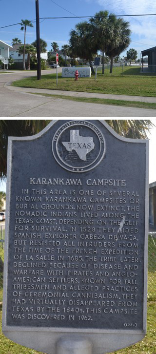
The traditional view of the Cabeza de Vaca story is that the Island of Misfortune is Galveston Island, the largest and most heavily-populated island in Galveston Bay. This view is represented on at least three historical markers that have been placed at various locations on Galveston Island:
In this area is one of several known Karankawa campsites or burial grounds. Now extinct, the nomadic Indians lived along the Texas coast, depending on the Gulf for survival. In 1528 they aided Spanish explorer Cabeza de Vaca ... - "Karankawa Campsite" historical marker placed in 1966.
First known to world history in 16th century from report of Spanish soldier Cabeza de Vaca who was shipwrecked on this island in 1528 ... - "West Galveston Island" historical marker placed in 1967.
Few spots have played a more exciting role in the life of Texas than Galveston Island. Cabeza de Vaca, the Spanish explorer, wrote of the cannibalistic Karankawa Indians when he was shipwrecked here in 1528 ... - "Galveston Island" historical marker placed in 1967.
Encyclopedias, almanacs, articles, and even history books state that Cabeza de Vaca landed on Galveston Island so simply and matter-of-factly, it is as if Cabeza de Vaca himself had written the words "Galveston Island" in his report to King Charles. No attempt is made to explain why Galveston is Malhado; it simply is.
One reason for this view may be the basic fact that Galveston Island is the only large landmass in Galveston Bay that is technically is an island; the other two large bodies of land are actually peninsulas, and all of the other true islands are small and do not face the ocean. To a casual reader who is familiar with the Galveston Bay area, it would seem so obvious that the Island of Misfortune is Galveston Island that doing in-depth research or analysis of the question would be a waste of time.
The next, more substantive, reason that Malhado has long been assumed to be Galveston is probably the Karankawa, who are mentioned on all three of the historical markers quoted above. One of the first Europeans to settle on Galveston Island was Jean Lafitte, the famous French-American pirate. When he arrived in 1817, the Karankawa were still there. The U.S. Navy ousted Lafitte from Galveston Island in 1821. Soon afterward, empresario Stephen F. Austin began bringing colonists into the upper Gulf coast area. The new settlers could not tolerate the Karankawa, and those natives who had not been killed by 1824 or 1825 were forced to relocate further down the coast to the Corpus Christi area. The entire upper Gulf coast of Texas was clear of Karankawa by the time the first settlers came to Follet's Island and the Bolivar Peninsula beginning about a decade or two later. The Karankawa, therefore, are associated with Galveston Island because that is where settlers in the Galveston Bay area had the most contact with them. Since the Isla de Malhado was known to have Karankawa, it was taken to be Galveston Island.
The first academic thesis that challenged the traditional identification of Malhado as Galveston Island appeared in 1918. After that, writers began hedging their articles with phrases like "probably Galveston Island" or "believed to be Galveston Island," while others broke away from tradition completely in favor of one of the other two candidates - Follet's Island and the Bolivar Peninsula. The residents of Galveston Island have not been willing to let Cabeza de Vaca go quietly, however. As it happens quite often with matters of history, once there is a local population with a vested interest in an important event being associated with their location - especially a town with a tourism board, a chamber of commerce, and a historical society - it becomes difficult to uproot. The three historical markers quoted above, all placed at about the same time, may well have been part of a local response to keep Cabeza de Vaca and the Isla de Malhado on Galveston Island in the face of emerging scholarly doubt.
The identity of the Isla de Malhado does not have to be an unsolved mystery. As the next section of this article shows, the texts authored or co-authored by Cabeza de Vaca give enough information to tell us conclusively where it was. It is time to retire the legends and assumptions about the identity of Malhado and replace them with conclusions based on the contents of the texts.
Textual Analysis
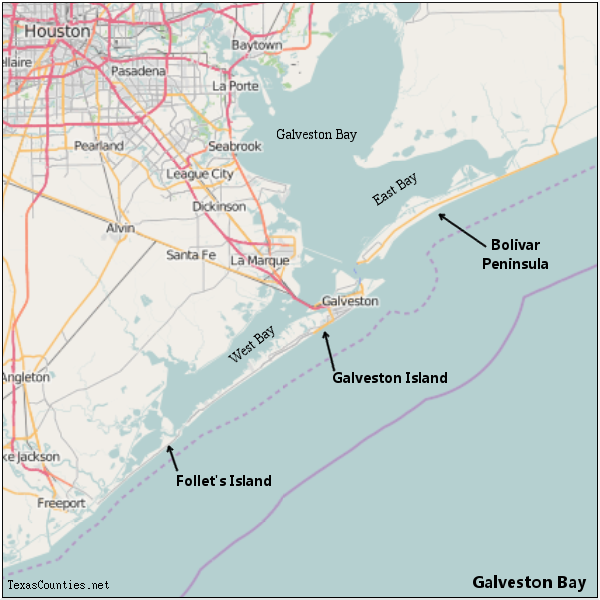
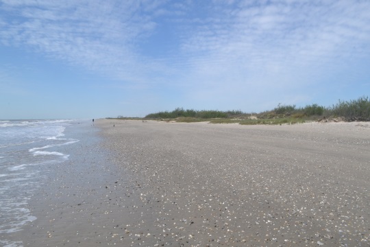
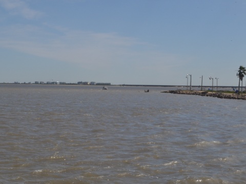
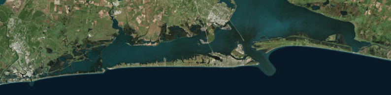
Figure 2, at right, shows an overview of Galveston Bay, highlighting the three ocean-facing bodies of land in it. There is enough information in the two chronicles of the Narváez Expedition to narrow the Isla de Malhado down to one of these landmasses.
Was the Island of Misfortune Actually An Island?
I ordered Lope de Oviedo, who was the strongest and most robust of all, to go to some trees that were close by there, climb one of them, survey the land we were in, and collect some information about it. He did so and learned that we were on an island. - La Relación1
As Figure 2 shows, there are currently three bodies of land in Galveston Bay that face the Gulf of Mexico: Follet's Island, which is actually a peninsula, joined to the mainland at its west end; Galveston Island; and Bolivar Peninsula, joined to the mainland at its east end. The above statement by Cabeza de Vaca that the castaways found themselves on an island would seem to leave it self-explanatory that they were shipwrecked on Galveston Island. After a moderate amount of textual examination, however, a different picture appears.
Let us first consider Lope de Oviedo's treetop observation. We do not know how tall this man was, but let us assume that he was close to six feet tall - which would have been tall for his day. This would mean his eyeballs were about 5½ feet high off of the ground. Over a flat surface, such as water or extremely level ground without many trees, he would be able to see slightly less than three miles before his eyes reached the horizon created by the curvature of the Earth.2 By climbing a tree, he raised the altitude of his eyeballs and elongated the distance to the horizon. If he found an exceptionally tall tree for that area and climbed twenty feet up, he would extend his sightline to 5½ miles in every direction. Galveston Island is nearly 30 miles long. How could Oviedo have seen that Malhado was an island, if said island was 30 miles long? It would take climbing a tower over 150 feet tall from the middle of Galveston Island to discern that it was an island by such an inspection. What we can take from the above passage, then, is that either: A) Oviedo saw that he and his comrades were on a body of land that was mostly surrounded by water and was presumed to be an island, B) they were on a body of land much smaller than Galveston Island, or C) both. If they were literally on an island, however, and Oviedo proved this by climbing a tree, they could not have been on Galveston Island.
The above passage is not the only one in which Malhado is described as an island, of course. The word isla is applied to it 22 times in La Relación. It also appears at least five times in Gonzalo de Oviedo's edited version of the Joint Report. In addition, both documents describe several crossings the Europeans and the Indians made from Malhado to the mainland and back. This still does not mean, though, they could not have actually been on a peninsula. A person on the end of a peninsula who had a canoe, which the natives did, would naturally use it to cross over to the mainland, rather than walking down the entire length of the peninsula, if doing so was easier and would save time. Depending on where their fishing and gathering spots were, they might spend months or years going back and forth this way without ever once walking to the other end, meaning that for all practical purposes, they were on an island.
It is also worth knowing that Follet's Island, one of the two alternatives to Galveston Island, may have actually been an island in the past. This question is discussed in a subsequent section in this article. For the moment, it should suffice to say that the people who gave this peninsula the name "Follet's Island" in the 1800s were not using the word "island" literally, so we must not assume that Cabeza de Vaca meant it literally, either.
Where the Boats Landed and Were Lost
Cabeza de Vaca writes that after Lope de Oviedo reported that they were on an island, he sent him back to get more information. Oviedo found a trail, which he followed for "nearly half a league" to a native village. Cabeza de Vaca and the other senior officer in the group, Inspector Alonso de Solis, made friends with the natives. A few days later, the Europeans attempted to relaunch their boat. Cabeza de Vaca describes the disastrous result:
We raised the boat out of the sand in which it was lodged. It was necessary for us to remove all of our clothing for this, and we endured great difficulty to cast it out on the water, because we were in such a state that other, much lighter things sufficed to put us in it. And so, we embarked. At two crossbow shots out at sea, such a great wave hit us that it soaked everyone. Since we were naked, and it was very cold, the oars dropped out of our hands. The next wave that hit us overturned the boat. The inspector and two others clung to it to save themselves, but the reverse happened, and the boat took them down and drowned them. As the coast is very rough, the sea threw everyone else in a heave, enveloped in waves and half-drowned, onto the coast of the same island.3
The above passage clearly describes an attempt to launch the boat directly into the ocean - not in a cove, inlet, or other protected area. First, the boat was overturned by two mighty waves. Then, three people clung to the wooden boat, expecting that it would float, but the undertow pulled them and the boat down, drowning them. This was clearly the same spot where the boat landed originally, when it was hurled up out of the sea by a great wave and landed on the beach with a heavy jolt, as prior to this attempt, the Europeans had not even dislodged the boat from the sand where it had come to rest.
Later that evening, the natives took the surviving castaways back to their village. It was there that Cabeza de Vaca learned that survivors from another one of the Narváez Expedition's five boats were on the same island. They were, Cabeza de Vaca writes, staying "behind us" with another group of natives. He learned that it was the group led by Alonso del Castillo and Andrés Dorantes, and their boat had landed "a league and a half from there." The other group was "behind" (atrás) the village, meaning they were east of it.4 If the village was in between the two boat landing sites, then Cabeza de Vaca's boats landed a half a league west of the village, or two leagues west of Castillo and Dorantes's boat. This is probably what the text means, for if the village had been west of both boats, Cabeza de Vaca would probably have written that the other boat was one league from his, rather than a league and a half from the village. At any rate, whether the boats landed one league apart or two leagues apart is not important; what is important to know is that Castillo and Dorantes' boat was east of Cabeza de Vaca's, but on the same island.
When the survivors from the two boats were together, they looked at their last boat and decided to try to use it. This boat, unlike Cabeza de Vaca's, needed to be repaired first. Once they had it ready, they put it on the water, but Cabeza de Vaca writes, "it could not stay afloat, and so it sank"5. The Joint Report states:
... they decided to patch up their boat and to embark in it. They went to work and repaired the boat the best they could. When they put to sea, these Spaniards were not able to keep themselves afloat, because of the wood worms and other problems.6
The description of the attempt to relaunch the second boat blames the failure on the poor condition of the boat itself, not on rough seas. Neither of the texts mention waves or rough water, and there was no loss of life. The boat was not pulled underwater by currents; it simply sank. We learn later in the same chapter of the Joint Report why this attempt was different. The next spring, after Dorantes gathered the survivors together to begin trying to walk to Pánuco, "the Indians took them another time in canoes across the bay where they had lost those boats." The second boat, it turns out, was lost in a bay, except that "bay" is not the best translation of the Spanish word used here, which is ancón. "Inlet" or "pass" would be better translations. Evidently, upon landing, either the men on that boat were able to steer into an inlet, or it was driven there by the wind and current. The water in this inlet was calmer than the waves hitting the beach. The editor of the Joint Report, Gonzalo de Oviedo, obviously flubbed in writing "lost those boats" and should have instead written "lost one of the boats," for we know that the first boat was launched into rough seas one or two leagues west of the second one.
The knowledge that one of the boats came to rest in a bay or inlet narrows down the prospects for the Island of Misfortune, for there are today only two possible locations on Galveston Bay where this could have happened. The first is San Luis Pass, between the east end of Follet's Island and west end of Galveston Island. The second is the channel between Galveston Island and the Bolivar Peninsula, which is known as Bolivar Roads. Since we know that Castillo's boat landed east of Cabeza de Vaca's, and both were on the same island, Castillo's had to have landed either on the eastern tip of Follet's Island or the eastern tip of Galveston Island. Cabeza de Vaca's boat landed a league or two west of Castillo's. The only way that the boats could have landed on the Bolivar Peninsula - or anywhere else at Galveston Bay besides these two locations - is if a pass or inlet existed 500 years ago that disappeared before the mid 1800s. While this is cannot be disproven, it is important to remember that any attempt to interpret the Castillo boat landing site as anywhere other than the east end of either Follet's Island or Galveston Island must account in some way for an inlet for which no historical record exists.
An Island Behind Malhado
The textual next clue about the shipwreck survivors' island comes from the Joint Report, which refers to the island a few times but does not use the name "Isla de Malhado," or any other name. That document's description of Andrés Dorantes' gathering together of the survivors who had scattered over the winter includes this sentence: "There was also an Asturian cleric and a black man on an island behind where they had lost the boats."7 The boats were lost on the Isla de Malhado, so this tells us that there was another "behind" it. As usual, the Spanish word translated here as "behind" is "atrás. When the expedition chronicles use atrás, they mean, "in the direction we came from, opposite from where we were going," i.e. east.
There are currently two islands near Follet's Island. Both are at the east end. Mud Island is on the mainland, or bay side, of the east end. The other is Galveston Island, which is across from San Luis Pass and northeast of Follet's Island. Another island, San Luis Island, once existed in between the eastern tip of Follet's Island and Mud Island. If Malhado was Follet's Island, the island "behind" Follet's was either San Luis Island or Galveston Island, with Galveston being more likely, as describing San Luis Island's position with respect to Follet's Island as "atrás" is debatable.
Galveston Island also has three islands near it. The first, of course, is Follet's, past the west end of Galveston Island and across San Luis Pass. Next is Pelican Island, which is on the bay side of Galveston's east end. Finally, there is the Bolivar Peninsula. If Galveston Island was Malhado then the island behind it, in the direction of Florida, was Bolivar.
Bolivar Peninsula has no islands neighboring it except Galveston, which by the language used in the text, is ahead of it (adelante), not behind it. The only land behind the Bolivar Peninsula is the mainland. This part of the text, then, excludes the Bolivar Peninsula from being the Isla de Malhado.
The passage about the island behind Malhado corroborates the passage about the bay where Dorantes's boat was lost, because it narrows down the setting of the narrative to the same two specific locations - the east end of Follet's Island and the east end of Galveston Island.
The Bay and Mainland
The Indians who kept me left the island, and went on canoes to the mainland, where there were some bays that had many oysters. For three months of the year, they eat nothing else, and they drink bad water. There is a great lack of firewood, and the mosquitos are in very great abundance. Their houses are built out of mats over many oyster shells. - La Relación8
They went to some swamps and lagoons to eat those same oysters which the Indians eat for three or four months of the year, without eating any other food. These natives experience great hunger, and they have great difficulty defending themselves, both in the day and in the night, from the mosquitos. There are so many of these insects that it is an unbearable thing to endure them. The Indians do not have firewood, and their only water is brackish. - The Joint Report9
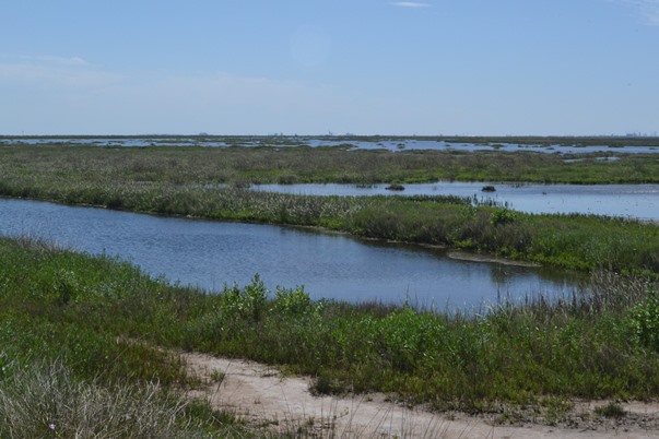
The above two descriptions of the bay and mainland adjacent to the Isla Malhado corroborate each other, and they provide many clues about Malhado's location. Compare the satellite photo of Follet's Island (left), Galveston Island (center), and the Bolivar Peninsula (right) in Figure 6, above. Note the dark green areas on the mainland. These are tidal wetlands - places that are near sea level and frequently underwater. These are also places where the many creeks and bayous in the area drain into the bay. The water can vary from fresh to brackish to salty, depending on the tide, the wind, and the amount of recent rainfall upstream. Plant life on the wetlands consists almost solely of grass, reeds, and leafy weeds. The many ponds of standing water are a haven for mosquitos. There is no doubt that the texts above are referring to these wetlands. As Figure 6 shows, wetlands are much more prevalent on the western half of Galveston Bay. They are especially prevalent on the western quarter, west of Chocolate Bayou and Chocolate Bay. Here, the large West Bay of Galveston Bay breaks up into numerous smaller, mud-bottomed, shallow bays ("swamps") and lakes ("lagoons"), including Oyster Lake, Alligator Lake, Cox Lake, Salt Lake, Nicks Lake, Drum Bay, Christmas Bay (also called Oyster Bay) and Bastrop Bay. These wetlands receive drainage from several nearby creeks and bayous, including Bastrop Bayou and Oyster Creek. Note that both text passages excerpted above mention "bays," "swamps," or "lagoons" in the plural. This best describes the western fourth of Galveston Bay - the part across from Follet's Island.
It does not take a Ph.D. in geography to notice that three of the water features mentioned at the end of the above paragraph have the word "oyster" in their names. The reason is obvious: the western fourth of Galveston Bay is known for an abundance of oysters. The Texas State Historical Association's article on Oyster Creek states:
Oyster shells, which give the creek its name, are common along its banks. During the 1950s mining these shells became a local industry. Tons were shipped annually for use in road construction and for making products such as buttons.10
While oysters are grown today all over Galveston Bay and the rest of the Gulf coast, all oyster production today is done on farms using manmade reefs. No other section of Galveston Bay has such a strong historic connection to the oyster as the bay area across from Follet's Island. The natives who Cabeza de Vaca and his countrymen stayed with ate nothing but oysters for three or four months, and there were so many oyster shells in their feeding grounds that they built their huts on top of the shell mounds. Everything about the texts' descriptions of the mainland, from the oysters, to the lagoons, to the lack of firewood, points to the area across from Follet's Island. This appears to eliminate the Bolivar Peninsula from consideration, for it is at least 30 miles from there to these oyster-rich swamps and lagoons. It also casts doubt on whether Galveston Island could have been the Isla de Malhado, because these wetlands are quite far from the eastern tip of the island, where the boats would have to have landed.
Order your copy of Children of the Sun: Following in the Footsteps of Narváez and Cabeza de Vaca, by David Carson of TexasCounties.net, available in E-book and paperback formats.
The Route to Matagorda Bay
Both of the expedition chronicles state that the group Andrés Dorantes led off of the Isla de Malhado crossed four rivers, then reached the first of several bays or inlets. The route that these travelers took is a subject of its own that requires much study and some speculation to interpret. For now, the main relevant part is the description of how the journey begins:
There was also an Asturian cleric and a black man on an island behind where they had lost the boats. They had crossed to this place because of the great hunger they had there. The Indians took them another time in canoes across the bay where they had lost those boats. In that place were those few Christians who had escaped the hunger and cold of winter. Thus, they gathered another six people, and all together there were now twelve Christians. ... The Indians led them across another bay to get certain things which they gave the Spaniards. From there they went two leagues to a great river which was beginning to rise from floods and rains... Leaving that place, they went three leagues to another river which was swollen and flowing very powerfully. Its fury was such that sweet water poured for a great distance into the sea. - The Joint Report11
As this passage states, the natives helped Dorantes, who was on the mainland at the time, round his people up, first taking him across to the island "behind" Malhado to pick up two people, then across the bay or inlet where Dorantes's boat had been lost back to Malhado to pick up six more. Finally, the natives took the group of twelve across another bay to get some gifts or supplies to give them. Dorantes and his people said goodbye to the natives there and began their overland journey. They crossed one river after two leagues of walking, then they crossed another, much larger, river after another three leagues. That means that in about 17 miles of travel - if the distance estimates are right - they crossed two sizeable rivers, the second one being the largest river out of the four that they crossed.
The passage above should be enough to narrow down the location from which the journey from the Island of Misfortune to Matagorda Bay started. The identification of the first river is debatable, but it is hard to see how the second river could be anything but the Brazos - one of the three largest interior rivers in Texas and the only one that empties directly into the ocean. It is important to know that the mouth of the Brazos was moved six miles west in 1929 to improve the river's usefulness as a port, but the old mouth and channel still exist. Working back 17 miles from the Brazos River, the journey had to have started somewhere around the eastern half of Oyster Bay or the west end of West Bay. Perhaps the second bay that they Indians took the group across to go collect some things was Chocolate Bay, West Bay, Bastrop Bay, or Oyster Bay, but it would have had to be in that general vicinity. The middle and eastern parts of Galveston Bay are simply way too far from the Brazos River to be the departure point for Dorantes and his people.
The Dimensions of Malhado
| Follet's Island | Galveston Island | Bolivar Peninsula | |
|---|---|---|---|
| Length: | 12.5 miles 3.6 co. leagues 4.8 st. leagues | 29.4 miles 8.5 co. leagues 11.4 st. leagues | 17.3 miles 5.0 co. leagues 6.7 st. leagues |
| Average Width: | 0.7 miles 0.2 co. leagues 0.3 st. leagues | 1.7 miles 0.5 co. leagues 0.7 st. leagues | 1.7 miles 0.5 co. leagues 0.7 st. leagues |
| Maximum Width: | 1.2 miles 0.3 co. leagues 0.5 st. leagues | 2.4 miles 0.7 co. leagues 0.9 st. leagues | 3.2 miles 0.9 co. leagues 1.2 st. leagues |
| Greatest Distance to Mainland: | 4.8 miles 1.4 co. leagues 1.8 st. leagues | 5.3 miles 1.5 co. leagues 2.0 st. leagues | 6.5 miles 1.9 co. leagues 2.5 st. leagues |
(One common league equals 3.46 miles. One statute leagues equals 2.59 miles.)
The text has more information that gives readers an indication which body in Galveston Island was Malhado: dimensions.12 In Chapter 15 of La Relación, Cabeza de Vaca writes, "The island is a half a league across and five in length." He also writes that it is "almost two leagues" from the mainland "where the water is the widest."13
Compare the figures Cabeza de Vaca gives with the dimensions of Follet's Island, Galveston Island, and the Bolivar Peninsula in Table 1 at right. The table shows distances in miles that have been converted to both common leagues, which were normally used for measuring travel distances, and statute leagues, which were used to measure the dimensions of tracts or parcels of land. (It can be proven that Cabeza de Vaca used common leagues elsewhere in his narrative, but this specific instance may have called for statute leagues, so both are shown.) Note that Follet's Island is, depending on the standard used, either 4 or 5 leagues, and Bolivar Peninsula is either 5 or 7. Both of them are in the ballpark. Galveston Island, however, is significantly longer than five leagues, regardless of the conversion factor used.
Cabeza de Vaca's figure of "half a league across" can mean a lot of things - was that an average width, the width at the location of his main camp, the width at its widest, or something else? Table 1 shows that all three land bodies can be described as half a league wide, depending on one's interpretation. This dimension, then is not very useful at the moment.
The third dimension Cabeza de Vaca gives is that the Isla de Malhado was "almost two leagues" from the mainland "where the water is the widest." This distance is difficult to measure for several reasons, but chiefly because so much of the area in question is marsh and wetlands. Did Cabeza de Vaca mean that the wetlands of the island were two leagues from the wetlands of the mainland, or were there two leagues from dry ground to dry ground? The latter makes more sense, for this is the distance one would have to travel when moving campsites from one side of the bay to the other. We must also consider the likelihood that these distances may have measured differently in 1528 than they do today, owing to different accumulations of sediment flowing from the creeks, and a high amount of dredging, canal-building, and other human activity since the mid-1800s. Perhaps the best interpretation is that any of the three land bodies could have fit the distance-from-the-mainland dimension.
While the width and distance dimensions Cabeza de Vaca gave are inconclusive and open to interpretation, the length is easy to interpret, and suggests that Malhado was not Galveston Island.
Conclusion: Follet's Island
The chronicles of the Narváez Expedition make it clear that the Isla de Malhado, where two of the boats washed up, was at Galveston Bay. There are only three bodies of land on Galveston Bay that face the sea. Of those three, when the information in the texts about Malhado is taken as a whole, Follet's Island is the only match. Galveston Island is too large, and while the west end of the island does work with some of the information in the texts concerning the bays and the mainland, the glaring problem with locating Malhado on the west end of Galveston Island is the discussion of Castillo's boat being lost and Dorantes gathering the survivors together occur on the east end of Malhado, not the west end. The east end of Galveston Island does fit selected parts of the narratives' descriptions of Malhado, but it is way too far from the oyster-rich wetlands on the adjacent mainland that are described so well in both texts. Furthermore, it is too far from the Brazos River. The Bolivar peninsula is approximately the right size, but fails all of the other criteria. Follet's Island is a near match on the dimensions and is an excellent match on all of the other criteria given in the texts. All legends aside, the texts tell us that the Island of Misfortune was Follet's Island and that one of the boats landed at San Luis Pass.
Follet's Island
The peninsula referred to in this document as Follet's Island does not appear to have an official name. Some historical documents refer to it as the Velasco Peninsula, after the town of Velasco, which was located on the east side of the Brazos River, where Surfside Beach is today. The names Rattlesnake Peninsula and Peninsula Point appear on some 19th-century maps produced by the U.S. Coast Guard. The name Follet's Island (or Follets Island) began to appear after the arrival of the Follett family after 1841. (One wonders whether the Folletts minded the misspelling of their name.) At least one academic paper on Cabeza de Vaca refers to it as Oyster Bay Peninsula. Recently, the names San Luis Peninsula or San Luis Island, which historically referred only to the eastern tip, have sometimes been extended to the entire landmass. This is probably because of its adjacency to the San Luis Pass, a readily-identifiable location that has had the same name for hundreds of years. If you were in Galveston, conversing with a typical resident, and mentioned you were going fishing on the San Luis Peninsula, he would probably know, or be able to figure out, what you meant, but if you said you were going fishing on Follet's Island, he would probably ask, "Where is that?" even if you were pointing to the southwest when you said it.
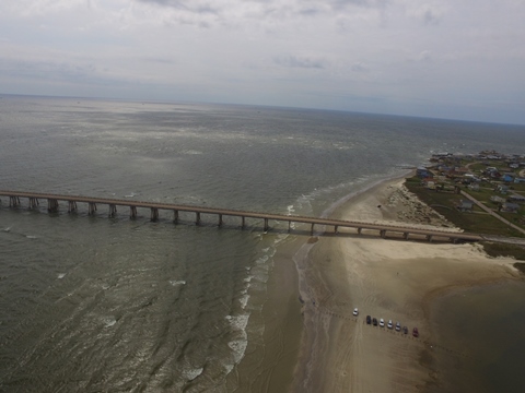
This article uses the name Follet's Island to refer to the contiguous stretch of land that fronts the Gulf Mexico from San Luis Pass to the former channel of Oyster Creek. Historically, Oyster Creek cut across the beach and emptied directly into the Gulf of Mexico. This changed after the Gulf Intracoastal Waterway was completed in 1941. The waterway now cuts across Oyster Creek and has effectively become its new channel and outlet. The old mouth of Oyster Creek has filled in with decades' worth of sediment and is now solid land. It is now possible to drive from San Luis Pass all the way to the east bank of the old Brazos River channel without crossing over water.
Even when Oyster Creek was open, Follet's Island was not a true island, due to the existence of about a 1-mile swath of wetlands between Drum Bay, which is the westernmost extension of Galveston Bay, and Swan Lake on Oyster Creek. A man-made canal was cut through here in 1855. That canal was made obsolete by the waterway.
Trees
The most solid objection to Follet's Island being the Island of Malhado is probably the passage quoted near the beginning of this article, where Cabeza de Vaca ordered Lope de Oviedo "to go to some trees that were close by there" and climb one of them. Looking around today, it would be hard to figure out where these trees might have been, and what kind they were. The only tall trees seen on Follet's Island today are the imported palms that are planted by homeowners and real estate developers. The island was known to have oleanders, which are woody shrubs that can grow quite large, in the late 1800's, but these were also imported. The other woody shrub seen on Follet's Island today is the salt cedar, a variety of tamarisk. These are medium-sized and, in most cases, too short and weak to climb, but even if they were bigger and sturdier, the point is moot: they were also imported. There are native live oaks on Galveston Island, and live oaks plus numerous other native trees on the mainland, but there are no native trees on Follet's Island today.
Whatever kind of tree Cabeza de Vaca saw and Oviedo climbed, if it still existed in the 1800s, it was eliminated by the salt cedar, a highly invasive species that is classified as an "agricultural pest" by the U.S. Department of Agriculture. Salt cedars not only thrive in salty soil, they actually make the soil saltier, so that native plants cannot exist among them. Salt cedars were introduced onto Follet's Island in the mid-1800s as ornamentals. They now populate the entire peninsula.

History
The geography of Follet's Island and the area around it has changed noticeably in the last two centuries. It is helpful when interpreting the Narváez Expedition Chronicles to review the peninsula's history of human settlement.
In 1832, Stephen F. Austin obtained the title to a league of land on San Luis Island. The origin of the name "San Luis" as it pertains to that island is uncertain, but it was already associated with the area when Austin obtained it. In 1838 or 1839, John Bradbury Follett moved his family over to San Luis from the west end of Galveston Island. Follett built a steamboat and shipyard. At its height in 1840, San Luis had 2,000 residents, two general stores, a newspaper, and other businesses. A ferry service operated from San Luis to Galveston Island. The town quickly declined, however, when a depression swept through Texas. Also, the harbor began to fill in with sand.
After Follett's death in 1846, his widow, Anne, and children moved to the peninsula south of San Luis Island. They opened a hotel named the Halfway House and began operating a ferry that provided service to both San Luis Island and Galveston Island.
In the late 1800s, the pass between Follet's Island and San Luis Island started filling in. The Follett family's ferry between the two islands was still operating as of 1885, but as of 1896, ships were unable to use the pass. Instead, they were using the pass between San Luis Island and Mud Island - a route described as "torturous" in a report by the U.S. Army Corps of Engineers. A 1905 Coast Guard map of the Texas coast showed the San Luis Island pass still open, but this was probably based on an outdated survey. The 1907 edition of the same map showed San Luis Island connected to Follet's Island on the seaward edge.
With the pass closed, the Folletts could no longer operate their ferry to Galveston Island. The hotel was probably already closed when it was leveled by the great hurricane that devastated the city of Galveston in 1900 and laid waste to the coastlines of Galveston and Brazoria Counties. The strip of land connecting Follet's Island and San Luis Island continued to widen, and it matured from a sandy beach into a tract of solid, dry land.
The San Luis Pass Bridge was completed between Follet's Island and Galveston Island in 1966. Development of the Treasure Island subdivision began on the east end of Follet's Island/San Luis Island soon afterward. A satellite photo from 1974 shows roads and a few houses built in the subdivision. It also shows a campground on the tip of the peninsula and another small subdivision on the western end of the peninsula, at the connection to the mainland. The campground is now a county park.
The Island Theory
The theory that Follet's Island was the Isla de Malhado was first advanced in 1918 by Harbert Davenport and Joseph K. Wells. Their reasons for rejecting the traditional identification of Galveston Island include some of those given above: "It is doubly too wide; three times too long; too far from the first of the four rivers; there are no woods opposite it on the mainland; and it has no island 'backward' from it (toward Florida)." They hypothesized that Follet's Island - or "the Oyster Bay peninsula" - was a true island when Cabeza de Vaca and his comrades were in Texas. Their idea rested on the belief that the silt deposited by Oyster Creek and the Brazos River was driven into a channel that once separated Follet's Island from the mainland.
There is no question that, in general, the natural accumulations of river and creek runoff and the frequent tropical storms and hurricanes that occur on the Gulf coast provide an ever-changing outline of islands, peninsulas, and channels. Davenport and Wells' theory is certainly plausible in light of the history of Follet's Island as presented in the previous section and in viewing the maps presented in Figures 5 and 6. In a span of just a few decades, a navigable channel closed in so completely that there is no trace of it today. Davenport and Wells noted several other channel closings known to have occurred along the Texas coast in recent times. They also asserted that the pass at San Luis Island "has been opened and closed several times in the past century" and suggested that it did not exist in 1822, ten years before Austin was granted title to the island. Davenport and Wells did not present any specific geographical or historical evidence to show that there actually was a channel separating Follet's Island from the mainland; they only asserted that it is reasonable, based the available evidence, to conclude that Follet's Island must have been a true island in Cabeza de Vaca's time.
The top half of Figure 8, above, shows a map made in 1853 by the U.S. Coast Guard. It is one of the earliest maps in existence that shows the west end of Follet's Island in detail. This map shows a small bayou draining into the west end of Drum Bay. That bayou is depicted on many other maps - sometimes more prominently, sometimes less, sometimes all but touching the beach, but never cutting all the way through. About a half a mile east of the west end of Drum Bay, there are spots where the bay extends southward, coming to within only 500 feet of the beach. It is certainly possible that either of these locations could have once been open to the Gulf 500 years ago, making the peninsula a true island. A third possibility is the aforementioned 1-mile swath of wetlands between Drum Bay and Swan Lake. This area is currently only a few inches above sea level and is filled with many small creeks and ponds, so it could have easily been waterier a few hundred years ago than it is today.
While Davenport and Wells' island theory is worthy of consideration and study, it is not essential for Follet's Island to have been an island for it to be the Island of Misfortune. As explained in the previous section, we would be reading the texts too technically to exclude Follet's Island from being Malhado because of a patch of low wetlands or a 500-foot-wide strip of sand at one end of it.
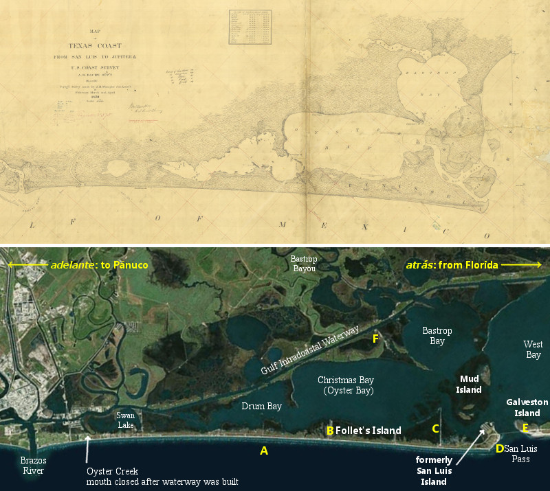
Interpreting the Island of Misfortune on Follet's Island
The bottom half of Figure 8 is a recent satellite image of Follet's Island. It and the 1853 map are shown at the same scale to make it easier to see the similarities, as well as the changes that over 150 years of natural and human activity have wrought. The labels in yellow represent one way to interpret the events recorded in the Narváez Expedition chronicles:
- A - Cabeza de Vaca's boat landed at about the middle of Follet's Island on November 6, 1528. Lope de Oviedo went exploring and found a native village a half-league away (B). The natives brought the explorers food. The castaways lost their boat in rough seas soon after reembarking in it.
- B - The natives who took Cabeza de Vaca's group in, possibly the Capoques, lived about a half-league from where their boat landed.
- C - Castillo's group was taken in by a different native tribe, possibly the Han.
- D - Castillo's boat landed at a bay or inlet a league and a half "behind" (atrás) the first native village (B) on November 5. This boat was in poor condition, and sank when they attempted to relaunch it.
- E - Two castaways spent the winter on an island "behind" (atrás) the bay or inlet at point D.
- F - The mainland across from the Isla de Malhado was characterized by swamps and lagoons, brackish water, and an abundance of oysters.
By David Carson
Page last updated: November 17, 2017
2This is calculated by taking the radius of the Earth (a), the Earth's radius plus Oviedo's height (c), and obtaining the sightline distance (b) using the Pythagorean Theorem, a2 + b2 = c2, expressed as b = √ (c2 - a2).
4The texts always used the word atrás to mean "back in the direction we came from," i.e. east.
6The Joint Report, Chapter 3.
7The Joint Report, Chapter 3.
9The Joint Report, Chapter 3.
10tshaonline.org, "Oyster Creek."
11The Joint Report, Chapter 3.
12This is frequently where route interpreters begin their analysis, but because of the likelihood of errors in estimation and recall, it is better to use dimensions as secondary evidence, rather than as our main analysis tool.
- Cabeza de Vaca, Alvar Nuñez - La Relación. Translated to English by David Carson, 2016
- "The Joint Report Recorded by Gonzalo Fernandez de Oviedo y Valdes," translated to English by Gerald Theisen, published in The Narrative of Alvar Nunez Cabeza de Vaca by The Imprint Society, 1972
- Davenport and Wells - "The First Europeans in Texas, 1528-1536" in Southwestern Historical Quarterly, Volume 22, July 1918 - April 1919
- Texas State Historical Association - The Handbook of Texas Online
- Treasure Island Civic Association - "Treasue Island - Our Beginning"