
The Narváez Expedition in South Texas
The Narváez Expedition in South Texas
Introduction
This article identifies the presence of survivors of the Narváez Expedition in south Texas from San Patricio County to the Rio Grande.
While most of the information we have about the Narváez Expedition castaways' travels through Texas deals with the upper and middle parts of the Texas coast, four different parties of the expedition, totaling approximately fifty men, set foot in south Texas. These flat, dry plains and the bays and marshes along their edge are where the expedition's survivors were whittled down to the four who eventually reached present-day Mexico.
The two written chronicles of the Narváez Expedition do not give enough information about the castaways' travels in this part of the state to let us pinpoint them to any specific location. In most cases, even our idea of which counties they visited is only an estimate. For that reason, we set aside the county-by-county format used for tracing their routes elsewhere in the state and instead use a format that focuses on each party at a time.
The first group of Narváez Expedition survivors to reach south Texas were the occupants of a boat commanded by captains named Peñalosa and Téllez. Interpreting the location of where this boat landed, however, requires information obtained from studying the whereabouts of the other survivor parties. For that reason, our study of the Narváez Expedition in south Texas begins with the second party of survivors to arrive in the area.
Map of South Texas
[-]Collapse Map [+]Expand Map
Order your copy of The Account of Cabeza de Vaca: A Literal Translation with Analysis and Commentary, translated by David Carson of TexasCounties.net, available in E-book and paperback formats.
Dorantes's Party
On November 5 and 6, 1528 two boats carrying about eighty survivors of the expedition landed on Follet's Island in Brazoria County. Within a few days of their arrival, four of the men began walking down the coast, hoping to reach the Spanish settlement of Pánuco, near present-day Tampico, Mexico. Of those who remained behind on Follet's Island, all but 16 died during the winter. When spring came, 13 of these men set out on their own march down the coast. They were led by two captains - Andrés Dorantes and Alonso del Castillo. The two chronicles of the Narváez Expedition - Álvar Núñez Cabeza de Vaca's first person account, entitled La Relación, and a "Joint Report" written by Cabeza de Vaca, Dorantes, and Castillo and subsequently edited by Gonzalo de Oviedo - imply that Dorantes was the main leader, and so this group is commonly known as "Dorantes's party."
Dorantes's party walked down the coasts of Brazoria County and Matagorda County, crossed Cavallo Pass in a canoe, and walked down the coast of Matagorda Island. In mid-April 1529, probably around April 12, the group reached Cedar Bayou, which forms the boundary between Matagorda Island in Calhoun County and St. Joseph Island in Aransas County. By that time, starvation and drownings had reduced their number to nine. (For more information, see our article, "The Narváez Expedition in Calhoun and Victoria Counties.") The next day, a native brought a Spaniard over to see them. The Spaniard's name was Figueroa, and he was the only survivor out of the four men who left Follet's Island the previous winter. He was living as a slave of one of the native tribes who lived on or around St. Joseph Island. Figueroa visited with Dorantes and his group for a while. When the native was ready to leave and take Figueroa back to St. Joseph Island, two members of Dorantes's party went with them. One of them returned a couple of days later, but the other stayed with Figueroa. That man's name is not known. La Relación calls him "a clergyman from Asturias" or "the Asturian," while the Joint Report refers to him by the nickname, "Asturiano." Dorantes's party lost contact with Figueroa and Asturiano for a while after that.
Next, Dorantes and the seven men with him stayed with some other natives for a few days, but the natives got tired of feeding them and recommended that they "go to some other Indians who they said were located on another bay (ancón, or inlet) six leagues ahead."1 Six leagues equals 21 miles, which is approximately the distance from Cedar Bayou to Aransas Pass. On the way there, two of the castaways died, and one became a slave of other natives, so only five castaways of Dorantes's party reached Aransas Pass. The first three were Castillo, Pedro de Valdivieso, and Diego de Huelva. Dorantes and his slave, Estevanico, came along a few days later. When Dorantes and Estevanico arrived, Valdivieso "came from where he was on the other side"2 to greet them. We know from this that Valdivieso was living on the west side of Aransas Pass when Dorantes and Estevanico arrived. It was May when Dorantes and Estevanico arrived at Aransas Pass, but it could have still been April when Castillo, Valdivieso, and Huelva arrived.
Aransas Pass is at the intersection of three counties. The pass itself separates St. Joseph Island, which is in Aransas County, from Mustang Island, which is in Nueces County. Directly across Aransas Pass, on the mainland, is the Aransas-San Patricio County line. The Joint Report states that the castaways "were enclosed by water, as there were islands all around where they were," "these natives do not eat anything except for some fish," and "they travel in flooded land and salt water."3 These descriptions strongly imply that they spent most of their time on the barrier islands and the smaller islands and marshes of Aransas Bay and, possibly, Corpus Christi Bay, and little, if any, time on the mainland, but since "they move frequently," some occasional visits to the mainland cannot be ruled out. The Joint Report indicates that the natives had a settlement that, at a minimum, Valdivieso and Dorantes visited, and implies that it was on Mustang Island. In summary, it seems safe to conclude that Dorantes's party dwelt for some time in Nueces County. Because of the close proximity of San Patricio County, it possible they also visited or dwelt there, even though the texts give no specific evidence that they did.
As stated earlier, Castillo, Valdivieso, and Huelva reached and apparently crossed Aransas Pass in either late April or early May 1529. It was May by the time Dorantes and Estevanico arrived. The Joint Report states that "soon after this," - whether "this" refers to Dorantes and Estevanico's arrival, or some other events that are described in the same paragraph is unclear - the natives killed Valdivieso "because he wanted to leave." Next, "after a little while," they killed Huelva "because he changed from one lodging to another." Whether both of these men died in May cannot be known for sure, but that is a reasonable interpretation. The others - Andrés Dorantes, Alonso del Castillo, and Estevanico - lived in the area for some time as slaves.
While the expedition chronicles attribute bad, violent, and disgusting behaviors to several of the native tribes of the Texas coast, they reserve their harshest judgment for these "bestial and bad people" who kept these three men as slaves and killed their two comrades. According to our analysis, this was the tribe Cabeza de Vaca identifies as the Quitoles. (For more information, see our article, "Interpreting the Territories of the Coastal Natives Described by Cabeza de Vaca.")
The three enslaved castaways escaped from the Quitoles one at a time. Dorantes was the first to leave. The Joint Report's description of the date of his escape is confusing:
The Spaniards were among these people for fourteen months. This was from the month of May until another month of May came in the next year. When this second month of May arrived, it was the year 1530. In the middle of the month of August, Andrés Dorantes was in a place which seemed to him most appropriate to seek escape.4
Note that the Joint Report seems to be ready to tell us that Dorantes escaped in May 1530, then it abruptly shifts the timeline to August. Oviedo, the error-prone editor of the Joint Report who miscounted the number of months between May 1529 and May 1530, apparently became confused over the fact that Dorantes fled from one group of natives to another twice within the same year. Further down, he writes:
After three months, the black man [Estevanico] went after him [Dorantes], and they met, although they did not remain together. ... Dorantes had gone another twenty leagues behind ... with some other natives, who were located at a river near the bay of Espíritu Santo.5
The easiest way to repair Oviedo's mangled timeline is to place Dorantes's escape from the Quitoles in May 1530, and Estevanico's three months later, in the first half of August. Then, in the middle of August, Dorantes escaped again, to a third group of natives. That left Castillo, who stayed "among those difficult people for another year and a half."6 If this interval is meant to start from the time Estevanico escaped, that means Castillo stayed with the Quitoles until about February 1532.
All three of the men who escaped the Quitoles did so by fleeing northeast into Aransas and Refugio Counties and out of south Texas.
Figueroa and the Asturian
As related in the above section, two castaways who originally landed on Follet's Island in November 1528 ended up together on St. Joseph Island in Aransas County in April 1529. They were Figueroa, who left Follet's Island a few days after the castaways landed only to become a slave of the natives on St. Joseph Island, and a clergyman known as "the Asturian," or Asturiano, a member of Dorantes's party. A native who was keeping Figueroa brought him across Cedar Bayou to see and visit with Dorantes's party on Matagorda Island on or around April 13, 1529. When the native was ready to leave and take Figueroa back, Asturiano and another member of Dorantes's party went with them. The texts specifically state that all three of these Spaniards could swim, implying that they swam across Cedar Bayou, rather than use a canoe. The next day, the third Spaniard went back to Dorantes's group on Matagorda Island, leaving Figueroa and the Asturian together on St. Joseph Island.
Dorantes's party lost track of Figueroa and the Asturian for a while. By early May, however, Andrés Dorantes reached Aransas Pass. When he got there, Pedro de Valdivieso, another member of his party who reached Aransas Pass a few days earlier, told him that Figueroa and the Asturian had been through there. According to the Joint Report:
The Indians had also stripped them and left them naked. They struck them many times with sticks, wounding them on their heads because the Christians did not want to stay with them. Thus, they departed both naked and bruised, even though they knew they might die. These Spaniards did this because they had made an oath not to stop until they reached the land of the Christians. Andrés Dorantes said that in that settlement he saw the clothes of one of these men. They were those of the cleric, and with these clothes were a breviary and a diurnal.
The settlement where Dorantes saw the clothes and religious books was apparently on the west side of the pass, on Mustang Island in Nueces County. Valdivieso's report to Dorantes about what happened to Figueroa and the Asturian seems to be based on first-hand observation; i.e. Valdivieso saw this happen to them and perhaps spoke to them. Dorantes arrived at Aransas Pass in May, but Valdivieso was there a few days earlier, perhaps in April. The texts provide no clue as to whether Figueroa and the Asturian were already at Aransas Pass when Valdivieso arrived, or whether they came through between his and Dorantes's arrival, nor do they state how long they stayed there, but it all had to have happened in either the second half of April or the first few days of May. According to our analysis, the natives who beat and stripped and battered Figueroa and the Asturian were the Quitoles, the same group that later killed Valdivieso and Diego de Huelva and enslaved Dorantes, Castillo, and Estevanico.
The chronicles mention Figueroa and the Asturian one more time. Years later, when Cabeza de Vaca and his three comrades were living with a tribe named the Avavares, the natives "told us that they had seen the Asturian and Figueroa with others who stayed further on the coast, who we called de los Higos." The English translation of this last tribe's name is "of the figs." The identification of this tribe is unknown. Their name may be a reference to ficus maxima, a species of fig tree that is native to Mexico, but none of the survivors of the expedition had any contact with either the De Los Higos or ficus maxima that we know of, so how they would have understood anything the Avavares said to mean "fig" is not easy to explain. It is entirely possible that whatever name the Avavares called this other tribe by simply sounded to the Spanish ear like "higos."
All we know about the De Los Higos is that they lived on the Gulf coast well south of Aransas Pass. In his list "of the nations and languages" of the tribes in Texas, Cabeza de Vaca places them the furthest south, beyond the Guaycones, who apparently inhabited St. Joseph Island; the Quitoles, who inhabited Aransas Pass; and another tribe named the Camoles or Camones. The Avavares, whose migratory range probably extended from around Jim Wells and Duval Counties to Hidalgo County, placed them as "further on the coast," i.e. south of them. Furthermore, the texts do not indicate that the Avavares had any direct contact with the De Los Higos or their two Spanish guests; they may have simply been passing along information that they learned from a third party to Cabeza de Vaca and his companions. This means that the De Los Higos could well have been somewhat remote from the Avavares. There may have been other tribes, besides the Camoles, in between the Quitoles and the De Los Higos, but Cabeza de Vaca was never told about them and, therefore, did not include them in his list.
In summary, it is safe to say that the De Los Higos lived on the coast south of Mustang Island, possibly on Padre Island, South Padre Island, or perhaps even further south and on the Gulf coast of Mexico. This would mean that Figueroa and the Asturian almost certainly visited Kleberg County and that there is a good chance that they visited Kenedy County. Whether or not they made it further south of there, or how far, is purely up to speculation. These two men, who were determined to make it to Pánuco at all costs, are not mentioned in the expedition chronicles - or in history - again.
Order your copy of Children of the Sun: Following in the Footsteps of Narváez and Cabeza de Vaca, by David Carson of TexasCounties.net, available in E-book and paperback formats.
The Four Ragged Castaways
Out of the hundreds of members of the Narváez Expedition who became stranded in the North American wilderness, only the ones known as "the four ragged castaways" managed to return to Spanish civilization. Three of these men were Andrés Dorantes, Alonso del Castillo, and Estevanico, who, as stated above, reached south Texas in April and May 1529, became enslaved, escaped, and retreated back to the northeast. The fourth ragged castaway was Álvar Núñez Cabeza de Vaca.
When Dorantes's party left Follet's Island and the Galveston Bay area in April 1529, three men were too ill to travel and had to stay behind: Cabeza de Vaca, Lope de Oviedo, and Jeronimo de Alaníz. Alaníz died, but Cabeza de Vaca and Oviedo recovered. Sometime in early 1533, they departed from the area and began their own journey down the Texas coast. After traveling through Brazoria and Matagorda Counties, they were helped across Matagorda Bay by some natives. They walked west across the mainland of Calhoun County and came within a few miles of the Guadalupe River. There, some natives called the Quevenes informed them that three of their countrymen were living in the area, that they were slaves and had been treated very badly, and that some of their other comrades had been killed. Oviedo became scared, went back east, and was never seen or heard from again. Cabeza de Vaca pressed on into the territory of the Mariames, who were keeping Andrés Dorantes as a slave. Cabeza de Vaca became their slave also. Castillo and Estevanico were living as slaves of their neighbors to the west, the Iguaces.
The Mariames and Iguaces' main areas of habitation were around San Antonio Bay and the San Antonio and Guadalupe Rivers, in present-day Calhoun, Victoria, Refugio, and Aransas Counties. The route that the four ragged castaways took from there has been a subject of debate that is now more than a century old and is still not firmly settled, although the options have been narrowed down. Several historians and authors in the 1800s and early 1900s had the castaways marching west or northwest across Texas as far as Abilene and crossing the Rio Grande for the first time at El Paso. More often than not, these trans-Texas route interpretations only attempted to solve the question of how much distance the castaways covered on each leg of the journey and ignored or glanced over most of the geographical information given in the two expedition chronicles - information such as the species of plants the castaways saw and ate for sustenance and the types of terrain they covered. These interpretations also did a poor job of locating the various native tribes Cabeza de Vaca mentions.
The first comprehensive Cabeza de Vaca route analysis, which considered all of the above factors and more in impressive detail, was done by Harbert Davenport and Joseph K. Wells and was published in two parts in 1918 and 1919. According to Davenport and Wells, the castaways traveled mostly south and southwest from the Guadalupe River and crossed over to Mexico in the lower Rio Grande Valley of south Texas. While it took some time for Davenport and Wells's conclusions to gain acceptance, and debates still exist over the specific locations of various waypoints on the castaways' route, their overall theory that the castaways walked through south Texas after leaving the Mariames and Iguaces and crossed the Rio Grande well below Laredo is now unchallenged.
The Tuna Fields
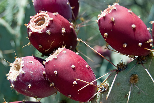
Like all natives tribes in the region, the Mariames and Iguaces were migratory, and sometimes traveled great distance for food. One of their annual migrations was into south Texas to eat "tunas," the fruit of the prickly pear cactus, known as opuntia in Spanish. According to Cabeza de Vaca, the tuna season was the highlight of the year for the natives:
Many times when we were with them, it would happen that we would go three or four days without eating; they, to cheer us up, would tell us to not be sad, for soon there would be tunas, and we would eat much, and drink their juice, and we would have very large bellies, and would be very content and merry, and without any hunger. From the time that they would say this to us until there were tunas to eat would be five or six months.7
Cabeza de Vaca writes the natives ate tunas "three months of the year, in which they do not eat anything else." This was also the time that the Mariames and Iguaces - who were "continually at war" because "everyone in the land is their enemy,"8 - engaged in trade with the other tribes. It seems that having plenty to eat made them less belligerent.
Cabeza de Vaca writes that when he had been with Dorantes and the Mariames for six months, the natives went "almost thirty leagues"9 to pick tunas. He and the other three Christians had a plan to escape, but they were unable to carry it out because the Mariames had a quarrel with the Iguaces and consequently kept their camps separated, making it impossible for Cabeza de Vaca and Dorantes to meet up with Castillo and Estevanico.
The castaways had to wait another year for their next chance. This time, Cabeza de Vaca informed the other three that the day of their escape would be the next full moon. This plan was announced on a date that Cabeza de Vaca states as "the first day of September and the first day of the new moon."10 There was not actually a new moon on September 1, 1534, so the first question is whether Cabeza de Vaca remembered the phase of the moon correctly or the date. On that, we consider it far more likely that he remembered the moon, since by this time it had been at least 6 years since his last look at a calendar. There was a new moon on September 8. We take this as the date Cabeza de Vaca guessed to be "the first day of September." This means the date of the full moon on which the escape was planned to take place was September 22.
As it happened, the castaways fled on the thirteenth day of the moon, or September 20. Cabeza de Vaca depicts this successful escape as occurring at or near the end of the tuna harvest.11 If the tuna harvest lasted three months and the escape happened near the end of it, then tuna season was, roughly speaking, July, August, and September.
To learn the location of the tuna fields visited by the Mariames and Iguaces, from which the castaways made their escape, we should, as always, take our cues from the texts. As noted above, Cabeza de Vaca estimated the distance that he traveled with the Mariames to the tuna fields as "almost thirty leagues," or about 100 miles. The Joint Report states, "they journey more than forty leagues forward, towards Pánuco, to eat them."12 Forty leagues equals approximately 140 miles. The disagreement between the two sources as to the distance adds a wrinkle in determining the cactus fields' location, and we should always keep in mind that both sources' estimates of distances tend to be too big. Still, if we accept the lower Guadalupe River as being in the heart of the Mariames' territory, we should expect to find the prickly pear fields approximately 100 miles from there. Davenport and Wells described several possible locations for the tuna fields, ultimately settling on southeastern Duval County, between the towns of San Diego and Falfurrias, as the location that not only answers the texts' descriptions the most accurately, but also was known to be abundant in prickly pears before man's arrival began to change the landscape in the mid-1800s. Southeastern Duval County is between 100 and 140 miles southwest of (or "towards Pánuco" from) the Guadalupe River, thus making it an excellent fit with the texts' distance estimates.
We have placed markers on the map in Figure 1 to show the lower Guadalupe River and Pánuco. (To see the marker for Pánuco, it is necessary to pan down or scroll out.) We have marked the approximate location of the tuna fields as interpreted by Davenport and Wells with a red circle.
Despite how well Davenport and Wells's analysis satisfies the requirements of the texts, Alex D. Krieger, whose route interpretation is generally very insightful, disagrees. Krieger believed that the castaways did not arrive at the Nueces River until after successfully making their escape, so the prickly pear fields where the Mariames and Iguaces camped had to have been east (or north) of the Nueces. He places the tuna field in south central Atascosa County, about 100 miles west-northwest of the Mariame homeland. This area is marked in Figure 1 with a blue circle. Whether this area could be considered "towards Pánuco," which is a requirement of the texts, is debatable at best.
If Davenport and Wells are right, the Mariames and Iguaces' route to the prickly pear fields would have been mainly through Refugio, San Patricio, and Jim Wells Counties, possibly skirting Bee and/or Nueces Counties, and ending up Duval County. If Krieger is correct, it is more likely that they traveled through Goliad, Bee, Live Oak, and possibly Karnes Counties to end up in Atascosa County.
The Avavares
Three of the castaways - Dorantes, Castillo, and Estevanico - initially fled from the Mariames and Iguaces in the tuna fields to a tribe named the Anagados. Cabeza de Vaca fled to a tribe he does not identify. The following day, on September 21, 1534, the four castaways were able to meet up together. Two days after that, they ran again. At the end of that day, they entered a village of a tribe named the Avavares. They stayed with these natives for eight months.
The Avavares had also come for the tuna harvest. They had set up their camp near the southern extent of the prickly pear fields. According to Chapter 21 of La Relación, five days after the castaways arrived, "all the tunas having been gathered," the Avavares departed to a new location. The journey to this new location took five days, and there were no tunas or any other kind of food along the way. The Avavares camped on a river "to look for a fruit of certain trees, which is like peas." Cabeza de Vaca writes that there were no trails in this part of the country, but there was an ample amount of firewood.13 Cabeza de Vaca writes that he got separated from the others while looking for the pea-fruit and was lost for five days. He then found the natives and his comrades at the river. The following day, they "went to where we found many tunas."14 If we are counting the days correctly, their arrival at this second prickly pear field occurred on October 8.
As usual, Davenport and Wells's analysis is valuable:
... South of this first great tuna field there is a belt of sandy soil, which includes, roughly, the present counties of Willacy, Brooks, and Jim Hogg, which is not adapted to growing cactus, and in which this plant is, and always has been, rare. This belt of sandy soil varies in width from forty to sixty miles, being widest near the coast, and extends westward from the coast almost to the Rio Grande. South of this sandy stretch there is another great tuna field, which includes Cameron, Hidalgo, and Starr Counties, where the prickly pear is even more abundant and prolific than in the region north of the sands and south of the Nueces; but whereas the northern tuna belt was until very recent years a vast prairie, with only occasional clumps of mesquite, live oak, and huisache, the tuna belt near the Rio Grande was, from the earliest historical times, interspersed with immense forests and impenetrable thickets of mesquite, ebony, huisache, guahillo, and other thorny trees and shrubs.15
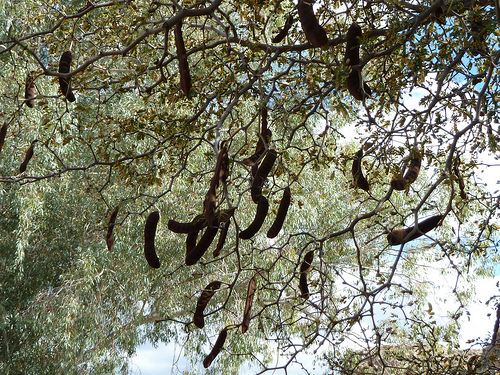
The information in the narrative, combined with Davenport and Wells' description of the soil and flora of south Texas, makes it relatively easy to follow the castaways' trail. If the prickly pear fields where the castaways escaped were in the vicinity of San Diego in Duval County, they crossed a few dozen miles of somewhat barren country - Brooks County - to reach the lower Rio Grande valley. The tree with pea-like fruit is certainly the Texas ebony, a tree of the pea family (Fabaceae). It grows seed pods that look very much like common pea plants, and its natural range is the lower Rio Grande valley of Texas and the Mexican states of Tamaulipas and Nuevo Leon. According to Davenport and Wells, "The northeastern and north central portions of Hidalgo County satisfy the requirements of the narratives for this winter home of the Avavares."16 Their choice of this specific location, as opposed to other parts of the lower Rio Grande valley, is due to the proximity of the Arroyo Colorado, a creek that runs through the city of Harlingen to the northeast and forms part of the boundary between Cameron and Willacy Counties. They believed this to be the river that the Avavares camped at upon their arrival to the area. If Davenport and Wells are right, then the Avavares and castaways backtracked somewhat from the Arroyo Colorado to get to their winter home. In addition to traveling through Brooks, Hidalgo, Willacy, and Cameron Counties, they may have also skirted Jim Wells and Kenedy Counties.
Krieger's analysis of this section is, frankly, not nearly as detailed as Davenport and Wells's. Krieger thought the river mentioned in Chapter 21 of La Relación to be the Nueces River. He needed a location on the Nueces where it could have conceivably taken five days to travel from where he believed the prickly pear fields were in Atascosa County, so he chose the "southward bulge of the Nueces" in La Salle and McMullen Counties. Unlike Davenport and Wells, Krieger does not discuss the soil or flora of these locations; he is only concerned with making the distances work. He placed the winter home of the Avavares as "a few miles south of the Nueces bulge," apparently in Webb and/or Duval Counties.
The winter home of the Avavares, as theorized by Davenport and Wells, is shown in Figure 1 with a red circle. Krieger's location for the Avavares is indicated with a blue circle.
To the Rio Grande
Cabeza de Vaca writes, "We stayed with those Avavares Indians eight months. (This is the count we made of the moons.)"17 A few paragraphs down, he repeats, "Of the eight months that we stayed with them ..."18 Since the castaways came to the Avavares in September 1534, this would mean they left in April 1535. The Joint Report, however, creates confusion in stating, "they rested from the first of October until the month of August came in the following year."19 Cabeza de Vaca's account is more credible, due it its more careful wording and the fact that it is repeated. Furthermore, Cabeza de Vaca adds, "At the end of this time, the tunas began to ripen." Tunas ripen over a period of months, becoming fully ripe in early August. In mid-spring, as the green fruit begins to turn to yellow-orange, one would see this process beginning. We reject, then, the Joint Report's statement that the castaways left the Avavares in August as a mistake and go with Cabeza de Vaca's version, which has them leave in April, or perhaps early May.
The castaways snuck away from the Avavares without saying goodbye. They went to another tribe one day's journey "further ahead," i.e. south or southwest. They stayed with them for a few days, then with another tribe, then walked another day and came to "a very large forest."20 After apparently another day of travel, they went to "a place where there were fifty houses."21. Leaving them, they went to a village where the natives ate ground mesquite pods. The people of this village escorted them across "a river that had water up to our chests."22 Cabeza de Vaca compared this river to "the one of Seville," i.e. the Guadalquivir River of Spain.
The identification of this river as the Rio Grande is the linchpin of Davenport and Wells's interpretation of the castaways' route. Interpreters who claimed that the castaways traveled west across Texas identified other rivers, such as the Colorado or the Frio, as the Guadalquivir-like river of La Relación. Davenport and Wells, as always, advance their theory with expert knowledge of both the relevant geography and the relevant sections of the Narváez Expedition chronicles. We do not repeat those arguments here, and to summarize them in one sentence would not do them justice, but we agree with their assertion that the evidence that this river is the Rio Grande is "overwhelming."
In contrast to other sections of La Relación, which provide enough estimates of travel times and distances to construct at least a rough idea of how much ground the castaways were covering, their journey from the Avavares to the Rio Grande is not estimated well at all. Cabeza de Vaca seems to allow for a minimum of three days' travel between leaving the Avavares and arriving at the large river, but the distance could have been significantly longer. The Joint Report adds no information to what is stated in La Relación.
The question of where the castaways crossed the Rio Grande from Texas into Mexico likewise requires us to draw conclusions from inexact information. Cabeza de Vaca writes that some unspecified number of days after crossing the river, "We began to see mountains here." This is the first time the castaways saw mountains since arriving on the North American continent. Cabeza de Vaca asked the natives where the mountains were in relation to the Atlantic Ocean (or "North Sea," as it was called then). From their answer, he believed that the distance was 15 leagues, or about 50 miles.
Davenport and Wells take these mountains to be ones they call the Pamoranes, which lie south of the Rio Conchos in Tamaulipas, near the boundary with Nuevo Leon. If these were the mountains mentioned, then Cabeza de Vaca's reckoning of the distance was quite accurate, for they are just a little over 50 miles from the Gulf of Mexico. Based on this and upon a review of Cabeza de Vaca's description of the dense woods in the area, the natives, and the food he and his fellow castaways ate, Davenport and Wells place their Rio Grande crossing at the town of Penitas, about 8 miles east of the Hidalgo-Starr County line. Both their Rio Grande crossing and the Pamoranes mountains are marked on the map in Figure 1 with red circles, although to see the latter, the map must be panned down or scrolled out.
Krieger, who has the castaways on a more westerly track all the way through south Texas, identifies the mountains in question as the Cerralvo mountains in Nuevo Leon, about 40 miles northeast of Monterrey. He places the Rio Grande crossing at Falcon Lake on the Starr-Zapata County line. Both of those locations are marked in Figure 1 with blue circles. If his analysis is correct, the castaways most likely traveled through Webb and Zapata Counties and possibly through Jim Hogg and Starr Counties.
As to the date that the castaways crossed the Rio Grande, leaving Texas, it was apparently in the summer, for the castaways did have tunas to eat before they crossed, but some were green.23. This hints they were still in Texas as of July.
Summary and Conclusion
As this section shows, interpreting the four ragged castaways' route through south Texas requires identifying four key locations: 1) the cactus fields where they escaped from the Mariames and Iguaces, 2) the Avavares' winter home, where the castaways resumed their journey after taking an eight-month rest, 3) the location where they crossed the Rio Grande, and 4) the mountains they saw after crossing the Rio Grande. Even the best analyses can only narrow down each waypoint to a general area. In comparing what we believe are the two best route interpretations, there is enough uncertainty about the castaways' travels that they could have been in any of the 21 south Texas counties depicted in Figure 1. There isn't any single county that both routes definitely trace them through.
We have presented both Davenport and Wells's and Krieger's theories in this article, primarily to show what the issues are and to emphasize that interpreting this part of Cabeza de Vaca's route is not as settled or clear-cut as it is elsewhere in Texas. Nevertheless, we do not believe both theories are equal; we believe Davenport and Wells's to be superior in all respects. Their first tuna field is "towards Pánuco"; Krieger's is not. They justify their assertions with pages and pages of descriptions of the lands in question; Krieger does not. Their concept of the Avavares' winter home is close enough to the coast to explain how they had news of Figueroa and the Asturian living on the coast with the Fig Indians; Krieger's is not. Their mountains are 15 leagues from the Gulf of Mexico; Krieger's are not.
The only weakness we can find with Davenport and Wells's theory is their identification of the Arroyo Colorado in Cameron County as the river mentioned in Chapter 21 of La Relación. This river is, no matter how one looks at it, more than a day from Davenport and Wells's choice for the Avavares winter home. Furthermore, it would have been well out of their way during a journey of five days when they had nothing to eat. It would have made much more sense for the Avavares to go from the first tuna field directly to the second one, and then to visit the river to collect ebony peas later.
Krieger also did not believe that the Arroyo Colorado was the Chapter 21 river; in fact, this is his only complaint about Davenport and Wells's theory, but it was a big enough problem for him that he constructed an entirely different route where the Nueces was the river in question. Krieger's objection to the Arroyo Colorado is different from ours, however; he simply looks at the number of villages, travel days, and layover days the expedition chronicles describe from the time the castaways left the Avavares to when they crossed the Rio Grande and concludes that it is "quite impossible when one considers all that happened to the travelers between the two rivers."24
While Krieger has a point, we do not believe that constructing a route that has even more problems is the answer. As stated in our article, "Challenges in Interpretation," the distances given in the expedition chronicles are probably the easiest thing for the writers to have gotten wrong, and we know of many instances where they are wrong. Perhaps Cabeza de Vaca remembered some distances in Chapter 21 incorrectly. And, for what it's worth, the Joint Report does not mention a river in the area where the seed pod trees were. We should not discount Davenport and Wells's excellent research on this topic because of their conclusions about a river that is only sketchily described in one of the documents and is not mentioned at all in the other.
Peñalosa and Téllez's Boat
The last party of the Narváez Expedition whose presence in south Texas we examine was actually the first party to arrive there: the occupants of the so-called "fifth boat." When the expedition left Florida, the men were on five boats. Four of the boats landed on the Texas coast in Matagorda County or higher, but the fifth boat landed well south of the others.
The expedition chronicles tell us little about the fifth boat. The only thing we know about its occupants is that Captains Peñalosa and Téllez were put in charge of it, and it carried 47 men, plus the two captains, when it left Florida. Two days after the five boats became separated from each other while crossing the Mississippi River, Cabeza de Vaca's boat found it. Their two boats then sailed together on the Gulf of Mexico for four days. In the afternoon or evening of November 4, 1528, two days before Cabeza de Vaca's boat landed on the coast of Brazoria County, the two boats became separated again. The next thing we read about the boat is that it landed significantly further south than any of the other boats, and all of its occupants were massacred by a tribe named the Camoles or Camones.
We can get a sense of how far south the fifth boat landed by the fact that none of the occupants of the other boats heard anything about it until they reached south Texas. Men from the other four boats all ended up hearing or finding out about each other by the time they reached present-day Calhoun County, which was within five months of landing. On the other hand, some of the castaways from the other boats made it at least as far as Aransas Pass, in Nueces County, and a few of them lived in that area for up to three years, yet none of them saw any trace of Peñalosa and Téllez's boat, nor did they hear or learn anything about it, until they traveled even further south several years later.
The "four ragged castaways" first heard about the fifth boat from a tribe named the Anagados. They told them about the massacre by the Camones, showed them some of the clothing and weapons belonging to the unfortunate Spaniards who came on the boat, and told them the boat "was there, on its side."25 We do not know whether the boat landed further up the coast and its occupants steered it to its ultimate resting place, or whether the boat remained where it originally landed, but the text implies that the men were killed close to the boat, meaning either that they were killed while camping or exploring near the boat, or perhaps even while landing it. It does say that the men were too weak to defend themselves, which further implies that they had not had a chance to recuperate after their grueling long-distance voyage on the Gulf of Mexico. All in all, the implied scenario is that the men were killed almost as soon as they and their boat first touched Texas sand.
The Anagados who reported the massacre to Cabeza de Vaca were a south Texas tribe. Since they had some clothing and weapons from the boat and could describe it lying on its side, they may have had direct contact with it. In his list "of the nations and languages" of the tribes in La Relación, which gives a rough breakdown of the various tribes' geographic relationships to each other, Cabeza de Vaca places the Camoles as dwelling down the coast from the Quitoles, who are believed to have inhabited the Aransas Pass area (For more information, see our article, "Interpreting the Territories of the Coastal Natives Described by Cabeza de Vaca.") We conclude from this information that the Camoles lived either on Mustang Island or north Padre Island, across from either Corpus Christi Bay or Baffin Bay. The massacre, then, most likely occurred in either present-day Nueces, Kleberg, or Kenedy Counties.
The texts tell us that all of the boats launched from Florida with about 50 men, but by the time two of them landed, they were down to 80 men between them. If all of the boats suffered about the same number of fatalities while out on the Gulf, then Peñalosa and Téllez's boat had about 40 men on it when it landed. According to our analysis of the five boats on the Gulf coast, the date of the massacre was around November 9, 1528.
Summary
| County | Castaways Who Visited | Dates | Castaways Who Died |
|---|---|---|---|
| Atascosa | (Krieger route) Dorantes, Estevanico plus Castillo plus Cabeza de Vaca |
Summer & Fall 1530, Summer & Fall 1531 Summer & Fall 1532 Summer & Fall 1533, Summer & Fall 1534 |
None |
| Bee | (Davenport and Wells route - possibly) (Krieger route) Dorantes, Estevanico plus Castillo plus Cabeza de Vaca |
Summer & Fall 1530, Summer & Fall 1531 Summer & Fall 1532 Summer & Fall 1533, Summer 1534 |
None |
| Brooks | (Davenport and Wells route) Four Ragged Castaways |
September 1534 |
None |
| Cameron | Figueroa and the Asturian (possibly) (Davenport and Wells route) Four Ragged Castaways |
Late April or early May 1529 until ? September 1534 |
Unknown |
| Duval | (Davenport and Wells route) Dorantes, Estevanico plus Castillo plus Cabeza de Vaca (Krieger route - possibly) Four Ragged Castaways |
Summer & Fall 1530, Summer & Fall 1531 Summer & Fall 1532 Summer & Fall 1533, Summer & Fall 1534 From September 1534 to May 1535 |
None |
| Goliad | (Krieger route) Dorantes, Estevanico plus Castillo plus Cabeza de Vaca |
Summer & Fall 1530, Summer & Fall 1531 Summer & Fall 1532 Summer & Fall 1533, Summer 1534 |
None |
| Hidalgo | (Davenport and Wells route) Four Ragged Castaways |
From September 1534 to July 1535 |
None |
| Jim Hogg | (Krieger route - possibly) Four Ragged Castaways |
May or June 1535 |
None |
| Jim Wells | (Davenport and Wells route) Dorantes, Estevanico plus Castillo plus Cabeza de Vaca |
Summer & Fall 1530, Summer & Fall 1531 Summer & Fall 1532 Summer & Fall 1533, Summer & Fall 1534 |
None |
| Karnes | (Krieger route - possibly) Dorantes, Estevanico plus Castillo plus Cabeza de Vaca |
Summer & Fall 1530, Summer & Fall 1531 Summer & Fall 1532 Summer & Fall 1533, Summer 1534 |
None |
| Kenedy | Peñalosa and Téllez's boat? Figueroa and the Asturian (possibly) (Davenport and Wells route) Four Ragged Castaways |
Approximately November 9, 1528 Late April or early May 1529 until ? September 1534 |
Peñalosa, Téllez, about 38 others? Unknown |
| Kleberg | Peñalosa and Téllez's boat? Figueroa and the Asturian |
Approximately November 9, 1528 Late April or early May 1529 until ? |
Peñalosa, Téllez, about 38 others? Unknown |
| La Salle | (Krieger route) Four Ragged Castaways |
September 1534 |
None |
| Live Oak | (Krieger route) Dorantes, Estevanico plus Castillo plus Cabeza de Vaca |
Summer & Fall 1530, Summer & Fall 1531 Summer & Fall 1532 Summer & Fall 1533, Summer 1534 |
None |
| McMullen | (Krieger route) Four Ragged Castaways |
September 1534 |
None |
| Nueces | Peñalosa and Téllez's boat? Dorantes's party Figueroa and the Asturian (Davenport and Wells route - possibly) Dorantes, Estevanico plus Castillo plus Cabeza de Vaca |
Approximately November 9, 1528 From late April 1529 to February 1532 Late April and/or early May 1529 Summer & Fall 1530, Summer & Fall 1531 Summer & Fall 1532 Summer & Fall 1533, Summer 1534 |
Peñalosa, Téllez, about 38 others? Pedro de Valdivieso, Diego de Huelva |
| San Patricio | Dorantes's party (possibly) (Davenport and Wells route) Dorantes, Estevanico plus Castillo plus Cabeza de Vaca |
From late April 1529 to February 1532 Summer & Fall 1530, Summer & Fall 1531 Summer & Fall 1532 Summer & Fall 1533, Summer 1534 |
None |
| Starr | (Krieger route - possibly) Four Ragged Castaways |
July 1535 |
None |
| Webb | (Krieger route) Four Ragged Castaways |
From September 1534 to June 1535 |
None |
| Willacy | Figueroa and the Asturian (possibly) (Davenport and Wells route) Four Ragged Castaways |
Late April or early May 1529 until ? September 1534 |
Unknown |
| Zapata | (Krieger route) Four Ragged Castaways |
July 1535 |
None |
By David Carson
Page last updated: September 18, 2020
1The Joint Report, Chapter 4.
2The Joint Report, Chapter 4.
3The Joint Report, Chapter 4.
4The Joint Report, Chapter 4.
5The Joint Report, Chapter 4.
6The Joint Report, Chapter 4.
12The Joint Report, Chapter 4.
15Davenport and Wells, p. 210.
16Davenport and Wells, p. 216.
19The Joint Report, Chapter 4.
24Krieger.
- Cabeza de Vaca, Álvar Núñez - La Relación. Translated to English by David Carson, 2016
- "The Joint Report Recorded by Gonzalo Fernandez de Oviedo y Valdes," translated to English by Gerald Theisen, published in The Narrative of Alvar Nunez Cabeza de Vaca by The Imprint Society, 1972
- Harbert Davenport and Joseph K. Wells - "The First Europeans in Texas, 1528-1536" in Southwestern Historical Quarterly, Volume 22, July 1918 - April 1919
- Krieger, Alex D. - We Came Naked and Barefoot, University of Texas Press