
The Old San Antonio Road in Sabine County
The Old San Antonio Road in Sabine County
- Map of the Old San Antonio Road in Sabine County
- Route Details
- Sabine River / Pendleton
- SH 21 / Milam
- Kings Road to the San Augustine County Line
The Old San Antonio Road in Sabine County passes through pine forests. Most of the land adjacent to the road is owned or leased by logging corporations. The small, unincorporated communities of Pendleton and Milam are the only population centers along the road. The OSR is preserved mostly by State Highway 21. A portion of the OSR west of Milam is preserved by a county road and an old dirt wagon trail. The segment of the route near the San Augustine County line is lost.
Map of the Old San Antonio Road in Sabine County
[-]Collapse Map [+]Expand Map
Route Details
- State Highway 21 from the Sabine River (Louisiana state line) for 7.5 miles to SH 87 in Milam. This segment has an inexact conformance to the OSR. SH 21 has two paved lanes and is undivided, with no shoulder, except east of and in Milam, where it has four lanes.
- SH 21 from SH 87 in Milam for 4.3 miles to the east end of Kings Road, exact conformance. SH 21 has two paved lanes, undivided, with no shoulder. A small section of it near the SH 87 intersection has curbs.
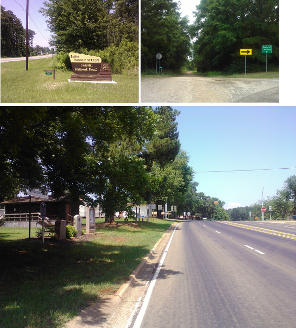
- Kings Road from its east intersection with SH 21 for 2.7 miles to where it makes a 45-degree angle to the right near its west end, exact conformance. Kings Road is a one-lane road that is nominally paved, but much of the pavement has eroded away, effectively making it a dirt road in places.
- Dirt trail on private property from the 45-degree angle near the west end of Kings Road for 0.4 miles to SH 21 at 0.2 miles east of County Line Road, exact conformance. This segment cannot be traversed by vehicle or on foot from the Kings Road end due to dense brush. The section closest to SH 21 could be traversed with an off-road vehicle, motorcycle, or horse. The interior is strictly a foot trail.
- SH 21 from the end of the dirt trail 0.2 miles east of County Line Road for 1.7 miles to Hight Lane, exact conformance. SH 21 has two paved lanes, undivided, with no shoulder.
- Route lost from SH 21 at Hight Lane for 0.5 miles to the Sabine-San Augustine County line at a spot 0.25 miles north of SH 21.

Bottom: Gaines Memorial Bridge, 2013.
Sabine River / Pendleton
Throughout the 1800s, travel on El Camino Real across the Sabine River was facilitated by a private ferry which had been operating since at least 1796. In 1819, James Taylor Gaines moved to Texas and purchased the ferry. Gaines was a member of the prominent Pendleton family, whose other members included General Edmund Pendleton Gaines, a hero of the War of 1812. After Texas won its independence from Mexico, Gaines founded a town at the ferry crossing. He named the town Pendleton. Gaines sold his interests at Pendleton in 1843.
In 1850, the state of Texas passed an act regulating ferries in the state. Thereafter, private ferry operators had to have a grant or license. Gaines Ferry, as it continued to be called, was still in operation when V.N. Zively surveyed the Old San Antonio Road in 1915. Zively planted his first oak survey post in Pendleton on the west bank of the river.
Gaines Ferry declined in the 1900s as the U.S. government began phasing out toll ferries and bridges at interstate crossings, and free bridges were built at other Sabine River crossings. In 1923, the Sabine County commissioners' court began subsidizing Gaines Ferry and ordered that it provide free service. As of 1926, the cash-strapped county was still allowing operators to collect a toll between sunset and sunrise, but eventually the federal government demanded 24-hour free service. The ferry finally ceased operation after a temporary bridge was opened at Pendleton in 1935. The permanent bridge was completed in 1937.
The Toledo Bend Reservoir, completed in 1969, turned this ordinary river crossing into the fifth-largest lake by surface area in the United States. The former town of Pendleton is now completely submerged. The unincorporated community of Pendleton Harbor now exists on the west bank of the reservoir. One building from the original town of Pendleton, the Gaines-Oliphant House built in 1818, still stands today in Pendleton Harbor. There are also some fishing and boating businesses in this recreation-oriented village.
Old San Antonio Road Marker #1 was moved when the reservoir was built. It is now on the west bank of the reservoir at the Gaines Memorial Bridge, 1.2 miles from its original location.
Bottom: Site of OSR Marker #3 in Milam.
SH 21 / Milam
State Highway 21 follows the Old San Antonio Road closely, but not exactly, from Pendleton to Milam. This stretch of Highway 21 runs through the Sabine National Forest.
The lumber industry, which emerged in Texas in the 1800s, was booming by the end of the century, especially in the dense piney woods of east Texas. In 1933, the state of Texas sold the land for the Sabine National Forest, located primarily in Sabine and Shelby Counties, to the federal government to manage the forests and help keep the lumber industry sustainable over the long term.
In 1935, the Civilian Conservation Corps came to Sabine County to develop the forest - setting up trails, campgrounds, lookout towers, water towers, etc. The CCC had a large encampment on Highway 21, 2.7 miles east of Milam, directly across from where OSR Marker #2 was surveyed. The camp was known to still be in operation as of 1939, and may have continued until the government shut down all CCC camps in 1942. From 1944 to 1945, the old CCC camp was used as a private branch agricultural camp for World War II prisoners of war. The facility was then dismantled and moved to Camp Hood (present-day Fort Hood).
The settlement of Red Mound was founded in 1828 at an artesian spring on El Camino Real. It was renamed to Milam in 1836 to honor Ben Milam, hero of the Battle of Bexar. The following year, Milam became the first incorporated city in Sabine County. It was the county seat until 1858, when voters elected to move the county seat closer to the center of the county and founded the new town of Hemphill for that purpose. After that, Milam began to decline. An 1873 effort to move the county courthouse back to Milam failed. The settlement remains today, but it is no longer an incorporated city.
Highway 21 through Milam follows the Old San Antonio Road precisely. Marker #3 is very visible at the intersection of Highways 21 and 87, and is at the same location that Zively surveyed.
Proceeding west from Milam, Highway 21 follows the Old San Antonio Road exactly, up to the point where 21 makes a sharp turn to the north. At that point, Highway 21 follows a different route of El Camino Real to the town of Geneva. At the spot where 21 turns north to Geneva, Zively's route of the Old San Antonio Road continues west along a local road appropriately called Kings Road.
Bottom: Topographic map showing the wagon trail.
Kings Road to the San Augustine County Line
As SH 21 goes west from Milam to San Augustine County, it makes a hump-shaped diversion through Geneva. A local road, Kings Road, forms the straight base of this hump, connecting with Highway 21 on both ends. Zively's route of the Old San Antonio Road follows Kings Road. The route followed by present-day Highway 21, which does not appear on Zively's survey at all, was an alternate route of El Camino Real that provided access to Carter's Ferry, a Sabine River crossing that no longer exists.
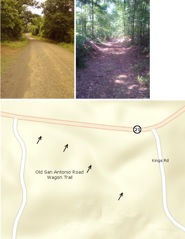
Kings Road is an old, rustic rural road whose surface has eroded away to dirt in many places. Driving down it slowly, one imagines that this is perhaps what the majority of the "camino arriba" looked like when Zively surveyed it in 1915, before Highway 21 and the other modern highways were built. Today, it has a smattering of rural homes - some dilapidated, and some of recent construction, and is also the address of a church and a cemetery near the west end.
Zively placed his survey post #4 a half mile from the east end of Kings Road, but the granite marker originally placed there is now in Geneva.
In the 19th century, the two routes of El Camino Real - the southern one marked by the Old San Antonio Road and the northern one that went through Geneva - connected at a fork about two miles east of the Sabine-San Augustine County line. This intersection has been changed in modern times so that instead of a fork, Kings Road connects with Highway 21 at a right angle. The old fork still exists as a dirt wagon trail through the woods, hidden away but accessible by foot from SH 21. When standing on this trail, it is easy to picture Stephen F. Austin, William Barrett Travis, and their contemporaries riding along it in the early 1800s, coming to Texas in search of fortunes and new adventures. The trail and its surroundings surely looked much the same to them as it does now.
At the west end of the dirt trail, Highway 21 resumes as the route of the Old San Antonio Road until about a half mile from the San Augustine County line. There, at Hight Lane, Highway 21 curves south. This turn of Highway 21 and its subsequent route into San Augustine County are shown on Zively's map as the "road now used", but he showed the Old San Antonio Road as going straight across the county line. The original road - apparently already out of use by 1915, is now on private property in the dense, brushy woodlands of the Sabine National Forest. Zively's survey post #5 would have been placed on the county line, about a quarter mile north of Highway 21, but as of this writing, its matching granite marker has not been mapped.
Page last updated: February 24, 2014
- Zively, V.N. - "Field Notes and Detail Map of the Kings Highway", 1916
- Carson, David - field notes observed and recorded in 2013
- Carson, David - Interview with Weldon McDaniel on June 15, 2013
- Texas State Historical Association - The Handbook of Texas Online