
The Old San Antonio Road Posts and Markers in Sabine County
The Old San Antonio Road Posts and Markers in Sabine County
Also see The Old San Antonio Road in Sabine CountyZively placed five oak survey posts in Sabine County: one at the eastern boundary, the Sabine River; one at the western boundary, the San Augustine County line; one in the town of Milam; and two at intermediate points. Four of the markers have been located, and all four are publicly accessible. The one at Milam is at its original location, while the other three have been moved. Two of the moved markers are still on Zively's route, but one was moved to a different route of El Camino Real.
Map of the Old San Antonio Road in Sabine County
[-]Collapse Map [+]Expand Map
|
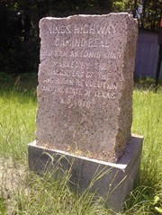
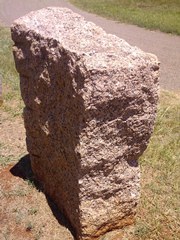
Marker #: 1
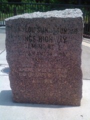
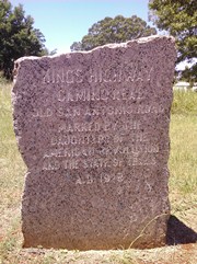
Coordinates: 31.462148, -93.753750 Location: SH 21 on the west bank of the Toledo Bend Reservoir Relation to Road: 48 ft from north stripe, facing away, NW 320° Distance from post: 1.2 mi west, on route Dimensions: 38" x 29" x 13" Setting: Concrete Other Markers/Signage: Yes Visibility: High Accessibility: Excellent The marker is at a small, unstaffed Texas visitor information center on the westbound side of the highway. At this center, which is raised about 5 feet above the highway, there are some other markers commemorating events associated with the Sabine River. There is also an informational display about El Camino Real that was posted there in 1991 as part of Texas' tricentennial celebration. (This display was badly faded as of 2013.) There are driveways leading to the displays, and a shaded seating area. The marker itself is atypical in two respects: first, it faces away from the highway, so that one must exit one's vehicle and walk around into the visitor center to read it. Second, it has an additional line of text engraved above the other inscriptions. This additional text reads "TEXAS LOUISIANA BOUNDARY." This marker had originally been placed 1.2 miles east of its current location, but it had to be moved with the construction of the Toledo Bend Reservoir in 1969, so as not to be submerged. It does still mark Zively's route at its current location. This visitor information center was constructed some time between October 2007 and January 2009. The Texas Society DAR's photograph of the marker, made between 1995 and 2001, shows it sitting on grass. Observed on August 10, 2013. |
|
|
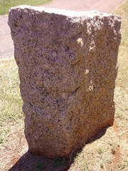
Marker #: 2
Coordinates: 31.44233, -93.77390 Location: SH 21 between the Toledo Bend Reservoir and Milam Relation to Road: 39 ft from north stripe, facing road, S 160° Distance from post: 1.9 mi west, on route Dimensions: 36" x 24" x 17" Setting: Concrete Other Markers/Signage: No Visibility: Medium Accessibility: Good in dry weather The marker is 1.1 miles west of Carrice Creek, 0.4 miles west of the entrance to the Sabine National Forest, and 0.7 miles east of Farm-to-Market Road 3121. The marker is on the north side of the road, in front of some metal buildings and a large advertising sign. It sits on a small mound in a field of tall grass. It is on a concrete base. It is easy to spot when approaching it from the west, but very difficult to spot when driving in from the east. There is no road pulloff or shoulder, but when the ground is dry, it is safe to pull off onto the grass. Parking a vehicle and walking to the marker could be difficult in wet weather. This marker has been moved 1.9 miles east of its original location. It still marks Zively's route at its current location. In 1933, the U.S. Civilian Conservation Corps had a large encampment east of Milam. The main camp was on the south side of the road, across from the marker's original location, but they also had a pavilion on the north side of the road. It is possible that the CCC moved the marker to keep it from being damaged or to move it out of their way. Regardless of who moved it or when, the reason why it was moved so far is not apparent. Observed on August 10, 2013. |

|
|
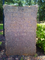
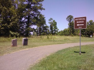
Marker #: 3
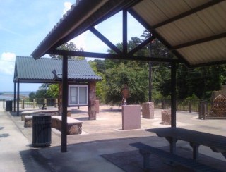
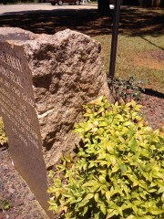
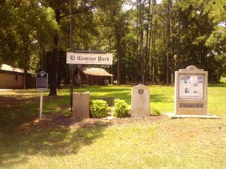
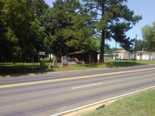
Coordinates: 31.43275, -93.84733 Location: SH 21 in the center of Milam Relation to Road: 17 ft from north curb, facing road, S 160° Distance from post: At post Dimensions: 39" x 25" x 13" Setting: Dirt mound topped with lava rock Other Markers/Signage: Yes Visibility: High Accessibility: Very Good The marker is in front of a small but pleasant park called El Camino Park on the north side of Highway 21, just west of the intersection of State Highway 87. The marker is grouped with some historical markers related to the town of Milam and a large El Camino Real tricentennial informational display provided by the state. There is no public parking per se close to the marker, but visitors will have no trouble finding a place nearby to stop their vehicle for a photo opportunity. This marker is at its original location. Observed on August 10, 2013. |
|
|
Marker #: 4
Coordinates: 31.475916, -93.917280 Location: On Highway 21 in Geneva Relation to Road: 39 ft from south stripe, facing road, NE 45° Distance from post: 1.4 mi north, off route Dimensions: 37" x 27" x 14" Setting: Dirt Other Markers/Signage: Yes Visibility: High Accessibility: Excellent The marker is on Highway 21, just north of the Geneva signpost and south of the intersection of Lee Arnold Road/Geneva-Sexton Road/Carter's Ferry Road/FM 330. Contrary to the norm, the marker is on the south or eastbound side of the road. It is next to a state historical marker for El Lobanillo Ranch, an early Spanish civil settlement. There are highway signs marking the location a mile in each direction, and there is a pulloff for vehicles. Zively placed the survey post for this marker 1.4 miles to the south, on Kings Road. That location is now private land and is a half mile from any paved road. The marker may have been moved to accommodate the landowners and/or to make the marker more accessible to the public. Regrettably, it was moved well off of Zively's surveyed route. At least at its current location, it does mark one of the alternate routes of El Camino Real. Nevertheless, this author hopes that one day the marker could be moved to the east intersection of Kings Road and Highway 21, where it will be back on Zively's route and only a half mile from its original location. The Texas Society DAR was unable to find this marker for its 1995-2001 rededication project. It may have been here, however, since 1972, which is the date on the El Lobanillo Ranch marker. The road pulloff is clearly visible on a 1996 satellite photo, and there appear to be the shadows of two objects in the photo. The marker was probably here at that time, but the researcher must have missed it because she probably only looked along Kings Road, not knowing the marker could be so far away from Zively's surveyed route. Observed on August 10, 2013. |
|
|
Marker #: 5
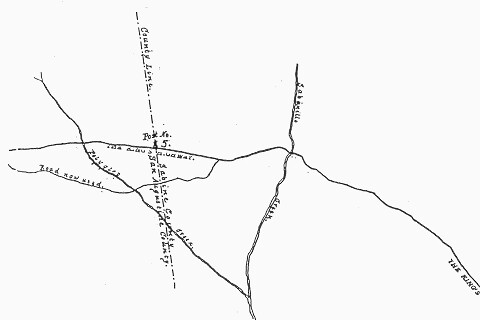
Coordinates: N/A Location: Not found Zively's fifth survey post was placed on the Sabine-San Augustine County line. On his sketch of the area, he showed a fork in the road about a half mile east of the county line. The fork occurred approximately at the present-day location of McMahan's Chapel Road. "The Kings Highway" was the northern fork, while the "Road now used" was the southern fork. The two forks rejoined west of the county line. Highway 21, which curves south sharply at McMahan's Chapel Road, is the "Road now used" on Zively's sketch. There is no trace of the northern fork, which Zively's sketch shows intersecting the county line about one quarter mile north of its intersection with Highway 21. This area is now on private property in the dense, brushy woodlands of the Sabine National Forest. The Texas Society DAR was unable to find this marker for its 1995-2001 rededication project. Sabine County historian Weldon McDaniel stated in a 2013 interview that he saw the marker in the woods decades ago, although he recalled it as being somewhat east of the county line. "Twenty years ago, it was back there," he said. Observed on August 10, 2013. |
|
- Zively, V.N. - "Field Notes and Detail Map of the Kings Highway", 1916
- Carson, David - field notes observed and recorded in 2013.
- Texas Society of the DAR - Old San Antonio Road DAR Marker Information Site
- Carson, David - Interview with Weldon McDaniel on June 15, 2013.
- Texas State Historical Association - The Handbook of Texas Online