
The Old San Antonio Road on the Leon-Madison County Line
The Old San Antonio Road on the Leon-Madison County Line
- Map of the Old San Antonio Road on the Leon-Madison County Line
- Route Details
- East of Normangee
- Normangee
- West of Normangee
The Old San Antonio Road has been used as a local boundary since Spanish colonial times. Today, State Highway OSR becomes the boundary between Leon and Madison Counties about a half a mile east of Interstate Highway 45. The country it passes through - level, and cut by many creeks, is ideal for cattle farming. The creeks on the eastern part of the county line drain into the Trinity River. The western part of the county line is in the Brazos River watershed. Normangee, the only town along this section of the Old San Antonio Road, is in the middle.
Map of the Old San Antonio Road on the Leon-Madison County Line
[-]Collapse Map [+]Expand Map
Route Details
- SH OSR becomes the boundary between Leon and Madison Counties about a half a mile east of I-45. For the next 19.6 miles, SH OSR is also known as County Line Road. It follows Zively's route precisely for this entire distance, except for three small zig-zags that have been straightened out. SH OSR has two undivided lanes, with no shoulders. In 1933, the only section open was between Highway 75 and Normangee; the rest was under construction. According to maps produced by the Texas Highway Commission, SH OSR was completed from Midway to Benchley by 1936.
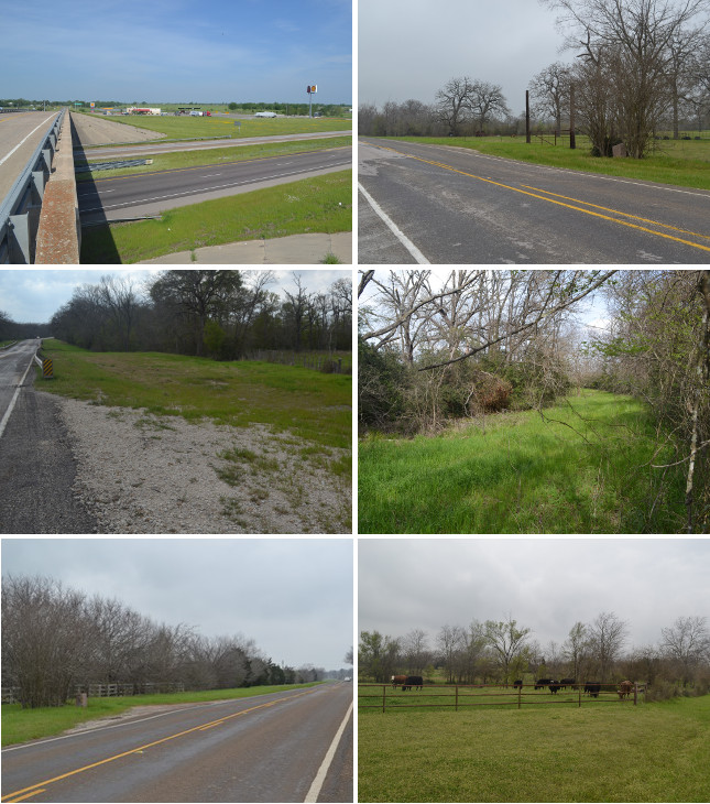
Middle (l to r): Remains of earlier Highway OSR route west of CR 405; this clearing previously used by Highway OSR is the true Leon-Madison County line.
Bottom (l to 4): Site of OSR Marker #38; cow pasture on the east bank of Salt Creek.
East of Normangee
When the Texas Congress created the original 23 counties in 1836, the Old San Antonio Road was the boundary between Nacogdoches County to the north and Washington County to the south. The counties have been subdivided several times since then; since 1853, it has been the boundary between Leon and Madison Counties. Today, Highway OSR merges with the county line about a half mile east of Interstate Highway 45. It is also known locally as County Line Road.
I-45 was the first interstate highway built in Texas. Built as a connection between Houston and Dallas, it largely overlays or parallels the route of the old U.S. Highway 75.1 The first sections of I-45 were opened in Houston in 1948. The section between Madisonville and Centerville, which is where it crosses the Leon-Madison county line, was completed in October 1967.
For about thirty years, the intersection of I‑45 and SH OSR, about 10 miles north of Madisonville, was just a lonely overpass in the countryside. The first businesses appeared in the mid-1990s. Today, there are two gas station/travel stops on the southbound side of the freeway, at the intersection, and the Yellow Rose RV Park further north. A rodeo arena, the Yellow Rose Arena, closed in 2012.
There is a dispersed rural community along Highway OSR less than a mile west of I-45. Zively referred to this place as Hennessey.
Zively placed the survey post for OSR Marker #37 on the east side of a stream he called Corn Creek. That stream is known today as Middle Branch Riley Creek. It empties into Caney Creek, which flows south through Madison County until it empties into Bedias Creek, which forms the county's southern boundary. Bedias Creek, in turn, empties into the Trinity River.
A mile west of Marker #37, Highway OSR crosses another branch of Caney Creek, named Pond Creek. Highway OSR's route has changed here since its original construction. It originally followed Zively's route and the county line, taking a crooked path for about a mile after crossing Pond Creek. It has since been redone to be much straighter, presumably to make it more suitable for today's highway speeds. A Texas Department of Highways map from 1940 shows the old route for SH OSR, so it was changed sometime since then. The clearing for the old, crooked route can still be seen both from the ground and in satellite photos. Some materials from the old route, including gravel and pieces of a concrete bridge support, still exist. Even today, some maps and GPS applications still incorrectly show the old route as a public road. Also, many modern maps incorrectly show the Leon-Madison county line following the new route, but the county line was not moved when the road was straightened.
Zivley placed his survey post for OSR Marker #38 west of Salt Creek, which is yet another branch of Caney Creek. A granite OSR marker found 1.5 miles further west along the road could be either Marker #38 or Marker #39.
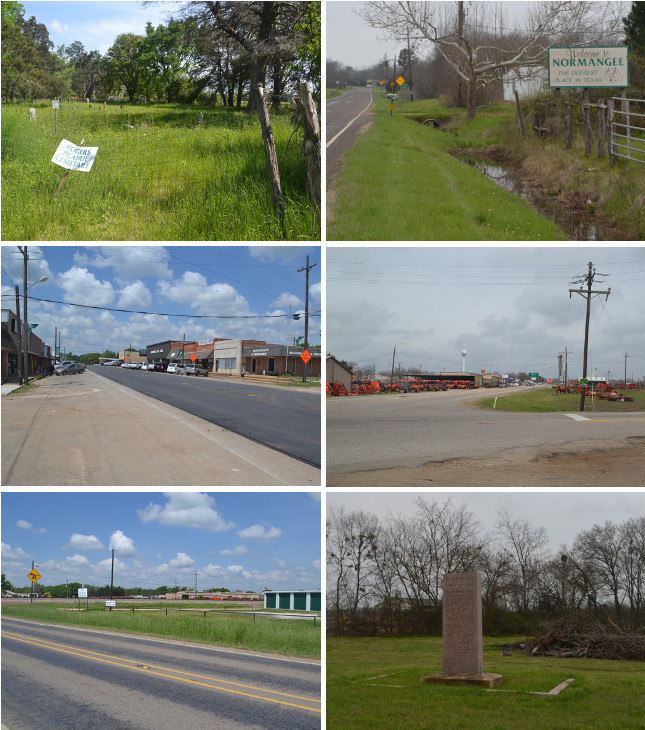
Middle (l to r): Main Street in Normangee; Normangee Tractor Co. at Highway OSR and FM 39.
Bottom (l to r): Surveyed location of OSR Marker #39; El Camino Real monument in Normangee.
Normangee
The first town in the area of present-day Normangee was Rogers Prairie. Rogers Prairie was settled in the mid 1830s to early 1840s by Robert Rogers. It was located on the Hollis Branch of Caney Creek, west of present-day FM 2289. The Rogers Prairie post office was established in 1874. The 1880 census recorded 48 people there. The town grew in the late 1800s and early 1900s, reporting a peak population of 216 in 1904. The town had a cotton gin, a gristmill, a church, a school, and a Masonic lodge. The thriving town's life was then suddenly aborted.
Railroad executive E.H. Harriman owned the Houston and Texas Central Railroad (H&TC), which provided service between Houston and Dallas. In 1905, Harriman decided to lay 94 miles of new track between two existing waypoints on the line: Nelleva in Grimes County and Mexia in Freestone County. This new 94-mile cutoff would shorten the H&TC's distance between Houston and Dallas by 15 miles. With speed in mind, Harriman laid out the shortest, most level route he could, and he placed a station where the new track crossed the Old San Antonio Road. It was nearly two miles west of Rogers Prairie.
Also in 1905, Benjamin F. Yoakum purchased the company that operated the Trinity and Brazos Valley Railway (T&BV), which had service from Mexia to Cleburne in Johnson County, south of Fort Worth. Over the next two years, Yoakum constructed a new 224-mile extension from Mexia to Houston, giving the T&BV a route between Houston and the Dallas area. Much of the T&BV's new track ran directly alongside the H&TC's new track. The T&BV also crossed the Old San Antonio nearly two miles west of Rogers Prairie; its track was only 300 feet from the H&TC's track. The T&BV opened its station on the OSR in 1907.
A new community immediately formed at the railroads. It chose the name Normangee after Norman G. Kittrell, a Texas lawyer, judge, and legislator who held elective office in Leon County from 1884 to 1893. Settlers at Rogers Prairie quickly moved west. The post office moved to Normangee in 1907. The school at Rogers Prairie was closed by the end of the year. Some buildings, including the church, were rolled from Rogers Prairie to Normangee on logs. A few people remained at Rogers Prairie, but the town dwindled out of existence by the 1940s. Today, only a neglected cemetery remains at the site. Records show that a state historical marker for Rogers Prairie was erected in 1980, but that marker is not there now. It was presumably located where an empty pulloff now exists on Highway OSR at County Road 486.
Normangee's population grew rapidly. The town incorporated in 1913. In 1914, Normangee had a population of 1,100, two cotton gins, two banks, hotels, churches, schools, and a weekly newspaper. Early in Normangee's history, however, the railroads that put the town on the map came into hard financial times. The unprofitable Trinity and Brazos Valley line filed for bankruptcy in 1914. The Houston and Central Texas fared even worse; it discontinued operations in 1933. In the 1940s, the H&CT station in Normangee was razed, and Farm-to-Market Road 39 was built on the rail bed. Normangee's population had dropped to 535 by 1940. Since then, it has fluctuated between 650 and 750. The former Trinity and Brazos Valley railroad is now part of the Burlington Northern Santa Fe system. Normangee is known today for two large tractor and farm supply dealerships at the intersection of Highway OSR and FM 39.
Normangee is on the westernmost branch of Caney Creek, which is the western edge of the Trinity River watershed. Most of the town is in Leon County, but some of it is across the highway in Madison County.
Zivley placed the survey post for OSR Marker #39 in Normangee at the northeast intersection of the Old San Antonio Road and the Trinity and Brazos Valley railroad track. The granite marker is not there today. A marker can be found 1.2 miles east of that spot, but whether that marker is Marker #39 or Marker #38, which is also not at its survey location, is anyone's guess.
Although Normangee's 1918 DAR granite OSR marker is gone, the town does have an El Camino Real/Old San Antonio Road monument erected by the state of Texas in 1936. This 8-foot tall granite stele, located in an otherwise vacant lot about 400 feet west of FM 39, bears an inscription about the founding and early history of El Camino Real. A rectangular concrete border surrounds the monument. OSR Markers #36, 37, and 38/39 are surrounded by similar concrete borders.
Bottom: Bridge over a small lake Zively called Lake Afton.
West of Normangee
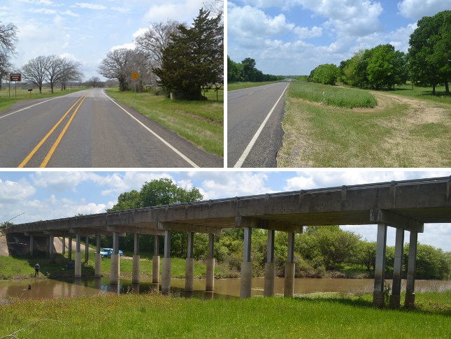
Leon and Madison Counties west of Normangee are in the Brazos River drainage area. The local streams flow into the Navasota River, which in turn empties into the Brazos. OSR Marker #40 is east of one of these streams, Cottonwood Creek.
There have never been any towns on this section of the road. Zively noted a place named "Sky" on his sketch, approximately where FM 1452 is today. It is unknown what this note refers to.
Between FM 1452 and the Navasota River, there is another place where Zively's route, the county line, and the original Highway OSR zig-zagged, but the highway was straightened sometime after 1940. Like the zig-zag at Pond Creek east of Normangee, some modern maps still show it incorrectly as a public road, and some modern maps also incorrectly show the county line as following the new, straightened section of the road.
About 0.3 miles east of the Navasota River, Zively's survey of the Old San Antonio Road shows a short detour around the northern edge of a body of water he called "Lake Afton." This long, narrow lake may be a remnant of another branch of the Navasota River. One old map, not very well-detailed, appears to show the Old San Antonio Road crossing two branches of the Navasota River that merge a short distance south of the road. Also, a modern U.S. Geological Survey map shows a dry river bed running alongside the east bank of the Navasota River. Regardless, a bridge now takes Highway OSR over the northern end of the lake, rather than deviating around it like Zively showed on his sketch. Apparently, this water crossing is quite old, because unlike the other two places along the Leon-Madison County line where Highway OSR deviates from Zively's route, the county line here follows the current highway route. Furthermore, a 1940 Texas Highway Department map corroborates the current route, not Zively's. Zively's route is also not evident either in satellite photos or from a personal site inspection.
Page last updated: April 27, 2014
1Between Conroe and Streetman, US 75, which connected numerous small towns, was left largely intact as a rural highway and "business route" through the towns, and I-45 was built on a new right-of-way as a bypass. These remnants of US 75 were redesignated as Texas State Highway 75 in 1987.
- Zively, V.N. - "Field Notes and Detail Map of the Kings Highway", 1916
- Carson, David - field notes observed and recorded in 2014
- Texas State Historical Association - The Handbook of Texas Online