
The Old San Antonio Road Posts and Markers on the Leon-Madison County Line
The Old San Antonio Road Posts and Markers on the Leon-Madison County Line
- Map of the Old San Antonio Road on the Leon-Madison County Line
- Marker #37
- Marker #38
- Marker #39
- Marker #40
Zively placed eight oak survey posts in Madison County and on its boundary with Leon County. Four them were on the Leon-Madison County line, as shown on this map. The matching granite markers for two of those posts are at or near their surveyed locations. A third found marker is about halfway in between the other two survey post locations.
Map of the Old San Antonio Road on the Leon-Madison County Line
[-]Collapse Map [+]Expand Map
|
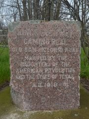
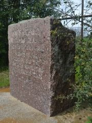
Marker #: 37
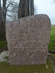
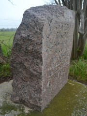
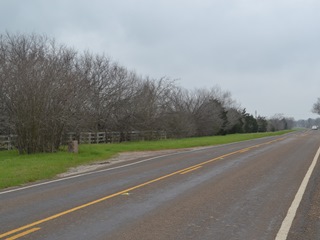
Coordinates: 31.076820, -96.002642 Location: Highway OSR, west of Interstate 45 Relation to Road: 20 ft from north stripe, facing road, SE 140° Distance from post: At post Dimensions: 35" x 29" x 14" Setting: Concrete and planted shrubs Other Markers/Signage: Yes Visibility: High Accessibility: Good This marker is on State Highway OSR, known locally as County Line Road, 2.8 miles west of Interstate Highway 45. It is about 300 feet west of County Road 405. There is a large stone ranch entrance across the road. The marker is at its original location. The marker is in front of a pasture fence, nestled among some planted crepe myrtle trees and shrubs in a shoulder of tall grass. The marker and plants are surrounded by a rectangular concrete border, which is mostly overgrown. Because of the plants, the marker itself is difficult to spot from the highway, but there is a brown historical marker sign across the street, making the site easy to find. There are no other historical markers at the site. A few feet down the road from the marker, the shoulder widens just a bit, allowing barely enough room to park a vehicle. The top of the marker slopes prominently from right to left. Observed on March 22, 2014. |
|
|
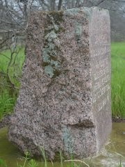
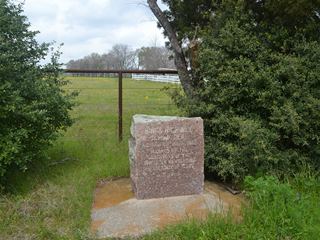
Marker #: 38
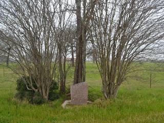
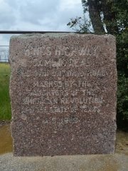
Coordinates: 31.03720, -96.09801 Location: Highway OSR east of Normangee Relation to Road: 22 ft from south stripe, facing road, NW 320° Distance from post: 1.5 mi from post, on route Dimensions: 32" x 25" x 19" Setting: Concrete Other Markers/Signage: Yes Visibility: High Accessibility: Good This marker is on State Highway OSR 0.7 miles west of Farm-to-Market Road 2289 and 1.2 miles east of FM 39 in Normangee. It is on the south side of the road in the grassy right-of-way between the highway and a pasture fence. The marker is set in concrete and surrounded by planted crepe myrtle trees. The setting is enclosed in a rectangular concrete border. The marker is easy to find thanks to a brown historical marker sign across the street. There are no other historical markers at the site. There is a small pulloff for parking. The marker is much deeper at the base. A bevel cut at the front bottom left corner is noticeable enough to be seen from a distance. There are some lichens on the surfaces of the granite. Marker #38 is supposed to be 0.8 miles east of FM 2289, near the bank of Salt Creek. This marker is 1.5 miles west of that location. It is also 1.2 miles from the surveyed location for Marker #39, which is missing. In other words, this marker is about halfway between two missing markers. It could be either #38 or #39. We identify this marker as #38 only to maintain consistency with previous research done by others. An El Camino Real/Old San Antonio Road monument erected in Normangee in 1936 could be a clue to how this marker got here. The concrete setting for the marker and the rectangular border surrounding it look identical to the concrete work done for the Normangee monument. It is reasonable to speculate, then, that this marker was moved here in 1936 concurrent with the placement of the monument in Normangee. Perhaps Marker #39 needed to be moved for construction in Normangee, and Marker #38 had already gone missing by then, so someone decided that the best thing to do would be to move Marker #39 to an approximate halfway point. Observed on March 22, 2014. |
|
|
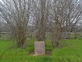
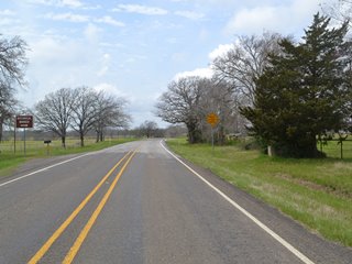
Marker #: 39
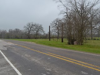
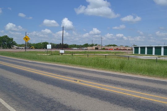
Coordinates: N/A Location: Not found Zively placed his 39th survey post in Normangee on the north side of the Old San Antonio Road and just east of the Trinity and Brazos Valley railroad track, which exists today as part of the Burlington Northern Santa Fe system. The pink granite marker that corresponds to this survey post has not been located. A city street named Hall Street now runs parallel to the railroad on the east side. It is possible that whatever happened to the marker happened when Hall Street was constructed. Another possibility is that the marker identified as OSR Marker #38, which is 1.2 miles east of the railroad track, is actually Marker #39 and that Marker #38 is the one that is missing. The photo at right shows the corner where the marker would have originally been located. Hall Road can be seen next to the white signs and the green storage building. The marker might have originally been in the vicinity of where the signs are now. Observed on April 19, 2014. |
|
|
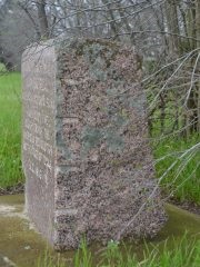
Marker #: 40
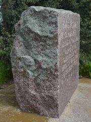
Coordinates: 30.992005, -96.186232 Location: SH OSR between Normangee and the Navasota River Relation to Road: 24 ft from north stripe, facing road, S 170° Distance from post: At post Dimensions: 32" x 28" x 17" Setting: Concrete Other Markers/Signage: Yes Visibility: High Accessibility: Medium This marker is on Highway OSR 5.0 miles west of Normangee and 3.6 miles east of the Navasota River. It is on the east bank of Cottonwood Creek, 1.4 miles east of FM 1452 and 0.4 miles west of CR 352. It is in front of one ranch and across the street from another. There is a historical marker sign across the street. There are no other markers at the site. There is no paved shoulder or pulloff at the marker, but the grass can be used for parking or, alternatively, there is a pulloff for a mailbox on the other side of the highway. The marker is across a ditch that could be difficult to cross over after a rain. The setting for this marker is more natural-looking than its neighbors in Leon and Madison Counties (Markers #36, #37, and #38/39). Like them, it is set in a wide square concrete base and is among some planted shrubs, but it is not surrounded by a rectangular concrete border or planted crepe myrtle trees. Consequently, the highway mowing crews are able to keep the area looking tidier than the markers that have received more elaborate setting treatments, but then left uncared for. It is also easier to spot from the highway, even without the signs. This marker is typical in appearance. It has lichens on its surfaces. This marker is at its original location. Observed on March 22, 2014. |
|
- Zively, V.N. - "Field Notes and Detail Map of the Kings Highway", 1916
- Carson, David - field notes observed and recorded in 2014