
The Old San Antonio Road in Burleson County
The Old San Antonio Road in Burleson County
- Map of the Old San Antonio Road in Burleson County
- Route Details
- Brazos River - Western Crossing
- Brazos River - Eastern Crossing
- East of Caldwell
- Old San Antonio Road in Caldwell
- SH 21 West of Caldwell
The Old San Antonio Road enters the northeast corner of Burleson County from Brazos County at two different crossings of the Brazos River. These routes join near Cooks Point. The Old San Antonio Road then runs southwest, passing through the county seat of Caldwell, and crosses into Lee County near Burleson County's southwest corner. All of the Old San Antonio Road in Burleson County lies within the Austin Chalk formation, an area actively being explored for oil. Much of it is preserved by State Highway 21, but some of it is on local roads, and some of it is lost.
Map of the Old San Antonio Road in Burleson County
[-]Collapse Map [+]Expand Map
Route Details
- Earlier route:
- Private road from the Brazos River for 0.9 miles to where CR 216 makes a 90-degree turn at its northern corner. This road is inacessible to the public, and its conformance to Zively's route cannot be determined.
- CR 216 for 2.4 miles from the 90-degree turn at its northern corner to CR 213. This section has an exact conformance to the Old San Antonio Road. CR 216 is one wide lane of compact dirt and rock.
- Later route:
- Route lost from the Brazos River for 0.3 miles to where CR 221 makes a 90-degree turn at its northern corner.
- CR 221 for 1.7 miles from the 90-degree turn at its northern corner to its intersection with SH 21. CR 221 has an inexact conformance to the Old San Antonio Road. It is one wide, paved lane.
- SH 21 from CR 221 for 1.5 miles to CR 213, exact conformance. SH 21 has four lanes, divided and with a wide grass median, and shoulders on the outside lanes.
- CR 213 from SH 21 for 0.5 miles to CR 216, exact conformance. CR 213 has one wide, paved lane.
- CR 216 from CR 213 for 0.3 miles to where CR 216 makes a 90-degree turn at its southern end. Exact conformance.
- Route lost from the 90-degree turn at the southern corner of C.R. 216 for 0.2 miles to S.H. 21, continuing along the line of the long section of CR 216.
- SH 21 from where it continues the line of CR 216 for about 4.9 miles approximately to FM 2000, exact conformance. SH 21 has four divided lanes with outside shoulders from the Brazos River to Caldwell except through Cooks Point, where it narrows to four undivided lanes with no shoulders.
- Route lost from approximately SH 21 and FM 2000 for 1.6 miles along a straight line to the intersection of Old San Antonio Road and Shaw Street in Caldwell. A few feet of this section near Shaw Street exist as a dirt road, but the rest of it is lost.
- Old San Antonio Road in Caldwell from Shaw Street for 1.4 miles to Hull Street, exact conformance. Old San Antonio Road has two undivided lanes with no shoulders.
- Route lost from the intersection of Old San Antonio Road and Hull Street in Caldwell in a straight line for 0.3 miles to SH 21 approximately at the southwestern Caldwell city limits.
- SH 21 from approximately the Caldwell city limits for 10.0 miles to the Burleson-Lee County line at East Yegua Creek, exact conformance. SH 21 has four lanes, divided and with a grass median, and with shoulders on the inside and outside lanes.
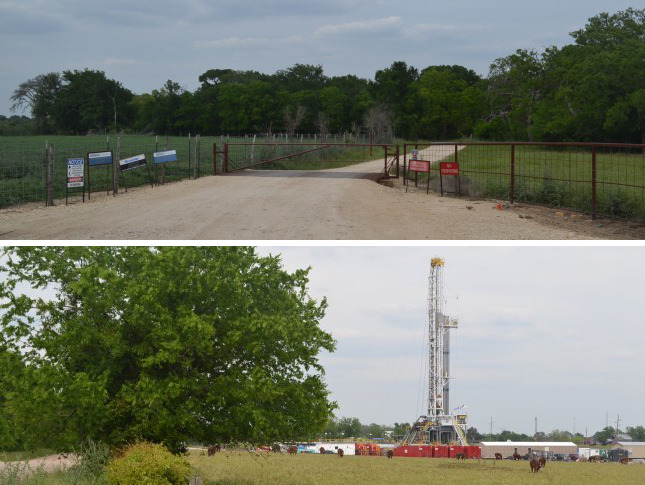
Bottom: Cattle graze while an oil well is drilled on CR 216.
Brazos River - Western Crossing
When V.N. Zively surveyed the Old San Antonio Road in 1915, he noted two crossings of the Brazos River about a mile and a half apart. He marked the section of the road using the western crossing "The Kings Highway." This crossing was used up to the middle of the 19th century. He noted it as being "at the Shoal Ford and at the N.E. corner of the Beverly A. Porter League - See County Map - Burleson Co." The Porter parcel Zively referred to is indeed easy to find on numerous property maps of Burleson County. The road on the Burleson County side of the Brazos River still exists, but it is now on private property and inaccessible to the public.
An important 19th-century site related to this Brazos River crossing was Tenoxtitlan. In 1830, Mexican General Manuel de Mier y Terán began implementing a plan to increase Mexican influence in Texas and check Anglo‑American influence. He ordered the construction of a new town at this location. The site was chosen because it was on the Old San Antonio Road on a major river about halfway between San Antonio and Nacogdoches. Mier y Terán envisioned Tenoxtitlan as the future capital of Texas. The officer in charge of the military garrison, Lt. Colonel José Francisco Ruiz, built a temporary headquarters at the Old San Antonio Road crossing, but the site he chose for the permanent fort was at a higher elevation about twelve miles upriver.
Tenoxtitlan was a Mexican garrison for only about two years. With Anglo-American immigrants still flooding into Texas, General Mier y Terán saw that his plan to Mexicanize Texas was failing, and he threw himself on his sword on 13 July 1832. Colonel Ruiz, a native Texan who was a friend of the Anglo‑American settlers and never shared his general's vision, evacuated his troops from the fort a month later. Anglo-Americans occupied Tenoxtitlan for the rest of the 1830s and beyond, but it was completely abandoned by 1860 because of continual attacks from Indians. A state historical marker sign for Fort Tenoxtitlan is now in a roadside park off of Highway 21 0.9 miles west of FM 1362.
About a mile from the Brazos River, the Old San Antonio Road becomes a public road, Burleson County Road 216. This road accurately preserves the earlier route of the Old San Antonio Road for about 2.7 miles between the Brazos River and Cooks Point. This is a rural area that is used mainly for oil and gas production and cattle farming.
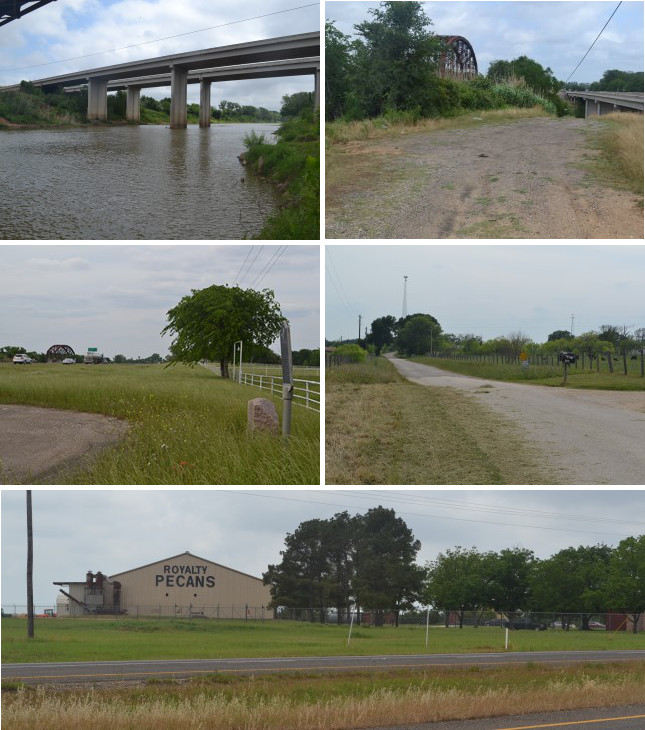
Middle (l to r): Site of OSR Marker #48; County Road 221.
Bottom: Royalty Pecan Farms on the Brazos River at Highway 21.
Brazos River - Eastern Crossing
A second Old San Antonio Road crossing of the Brazos River developed during the mid-1800s, probably during the 1840s. That crossing, about a mile and a half downriver of the earlier one, might have been a reaction to continual Indian attacks further up the Brazos. It also was apparently the preferred crossing for local travel between Boonville, which was established in present-day Brazos County in 1841, and Caldwell, established in 1840. A ferry was set up at the new crossing in the late 1840s. Texas maps from the early 1850s on show a separate river crossing for the Boonville-Caldwell highway downriver of the Old San Antonio Road crossing, which was still a ford. It seems that the Old San Antonio Road itself was rerouted to use the newer crossing over the next few years. The earlier crossing closer to Tenoxtitlan begins to disappear from maps in the early 1900s and isn't found on any maps from 1919 on.
Daniel Moseley took over operation of the ferry across the Brazos River in 1849. It became known as Moseley's Ferry. The ferry was in operation until 1912, when the Houston & Texas Central Railroad constructed a bridge over the river.
Zively placed the survey post for OSR Marker #48 at Moseley's Ferry between the Old San Antonio Road and the railroad track. One of the photos to the right shows a location that might be close to the spot where the marker was originally placed. It is now on the southeast side of Highway 21 about 0.2 miles from the river. A state historical marker sign for Moseley's Ferry is with the marker.
After crossing the Brazos River, the newer route of the Old San Antonio Road went southwest. County Road 221 follows this route from the river to Highway 21. Highway 21 then follows it up to CR 213, a short road that connected the later route of the Old San Antonio Road with the earlier route.
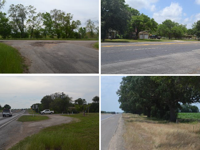
Bottom (l to r): Site of OSR Marker #50 in Cooks Point; site of OSR Marker #51.
East of Caldwell
As the previous sections explained, the Old San Antonio Road had two routes across the Brazos River. A segment of the route used up to the mid-1800s has been preserved as County Road 216. The route that superceded it in the late 1800s followed CR 221 and Highway 21. Just before Cooks Point, a short road, CR 213, connects the two routes. This is where people traveling the later route cut back over to the original route. Zively placed the survey post for OSR Marker #50 at the T intersection of what are now CR 213 and CR 216. From there, he surveyed only one road - today's CR 216 - into the town of Cooks Point. CR 216 has since been altered so that it makes a 90-degree turn just before Cooks Point and intersects Highway 21 at a right angle.
Cooks Point began as a trading post established around 1840 by Gabriel Jackson at the crossroads of the Old San Antonio Road and the Colonial Road, which went from Washington-on-the-Brazos to Tenoxtitlan. The location was named Cooks Point after Silas L. Cooke, a surveyor who lived in the area during the Republic of Texas. The town got started in 1854, when Andrew S. Broaddus led a wagon train of 80 white settlers and 120 black slaves there from Virginia. After the Civil War, German and Czech settlers moved into the area. The population of Cooks Point was 100 in 1881. It was 80 in 2000. Today, it has some brick houses, a church, cemetery, and a gas station/convenience store on Highway 21.
A little west of Cooks Point, Highway 21 picks up Zively's route of the Old San Antonio Road and follows it exactly for several miles. Approximately at OSR Marker #51, Highway 21 begins to veer south of Zively's route on the way to Caldwell. By the time Highway 21 reaches Highway 36 in Caldwell, it is about 0.2 miles south of Zively's route. Part of the historic route is still used as a property boundary, but otherwise, it is lost.
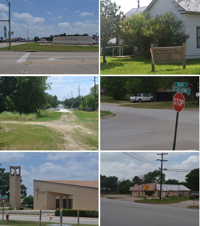
Middle (l to r): North end of Old San Antonio Road; intersection of Main St. and Old San Antonio Road.
Bottom (l to r): St. Mary's Our Lady of Lourdes Church; site of OSR Marker #52.
Old San Antonio Road in Caldwell
Caldwell, at the intersection of State Highway 21 and State Highway 36, was founded in 1840 as the new seat of Milam County after that county's boundaries were enlarged. When Burleson County was created in 1846, Caldwell became the seat of the new county. The population was 300 in 1856.
In 1880, the Colorado and Santa Fe Railroad built its main line through Caldwell and placed a depot a half mile from the courthouse square. A second railroad, the Houston and Texas Central, built a line through in 1912. Thus, Caldwell became a hub for both freight and passenger traffic. Its population in 1940 was 2,165. A municipal airport was built in 1968, providing general aviation services. Caldwell continued to grow in the late 20th and early 21st centuries, with much of its economy based on the area's thriving oil industry.
Immigrants from eastern Europe, especially Czechs, came to Burleson County and Caldwell in the late 1800s. Today, Caldwell is the home of the Czech Heritage Museum, and the city, known as the "Kolache capital of Texas," holds an annual festival to celebrate the Czech pastry.
The historic Old San Antonio Road through Caldwell is now preserved as a city street by the same name. It starts just west of Highway 36, about two blocks north of Highway 21. It consists of dirt tracks in the grass for about a block, then it becomes paved. It roughly parallels Highway 21 on the northwest side of town for about 20 blocks. It passes through a residential area on the north side of town, then becomes more industrial on the west side.
Zively noted a Catholic church on the Old San Antonio Road in Caldwell in his 1915 survey. This church, St. Mary's Our Lady of Lourdes, was founded in 1893 to serve the Catholics who immigrated to Burleson County from eastern Europe in the late 1800s. The church still exists on the same site, in a modern building. A state historical marker sign was erected there in 2005.
Zively placed the survey post for OSR Marker #52 near the intersection of present-day North Temple Street and Old San Antonio Road. The marker can now be found on Highway 21 at North Hall Street.
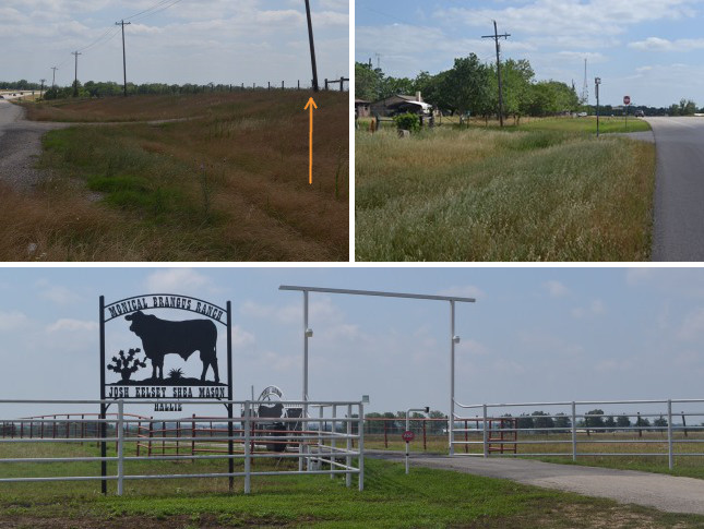
Bottom: Cattle ranch southwest of Caldwell.
SH 21 West of Caldwell
Highway 21 apparently followed a different route southwest of Caldwell than it does today. Maps from before 1930 uniformly show Highway 21 as a straight line from Caldwell to Giddings in Lee County, with some giving additional detail of it passing through Deanville and/or Dime Box. A 1922 Texas Highway Department map shows Highway 21 running parallel to and south of the Southern Pacific railroad track that still exists between Caldwell and Giddings. Maps from 1930 and later, on the other hand, show Highway 21 on its present route along the historic Old San Antonio Road. The state highway now preserves Zively's route from about the Caldwell city limits on the southwest side of town for 10 miles all the way to the Burleson-Lee County line. OSR Marker #53 is about halfway between Caldwell and the county line.
This section of Highway 21 is intersected perpendicularly at regular intervals by county roads that represent the boundaries of land grants made to the original colonists through Stephen F. Austin's empreserial contract. One of these, County Road 130, was originally the eastern boundary of a large tract belonging to Austin himself. Zively noted this boundary on his survey and placed the post for OSR Marker #54 where it intersected the Old San Antonio Road, noting the spot as "N.E. Corner Stephen F. Austin's Five League Survey."
Today, the area between Caldwell and Lee County is used for cattle ranching, but it used to have a different significance to the cattle industry. After the Civil War, ranchers and cowboys drove their herds up through central Texas on their way to the Red River, eventually reaching the market in Kansas via the Chisholm Trail. In Burleson County, a well-used route passed up from Matagorda County through Deanville, about 2 miles south of the Old San Antonio Road. It crossed the road near present-day CR 130 and went north toward Waco, where it merged with the main trail from San Antonio. Historians differ as to whether Texas cattle trails such as this one should be considered as part of the Chisholm Trail, or whether the Chisholm Trail should be considered as beginning at the Red River, thereby making this a feeder trail. Regardless, a state historical marker sign on Highway 21 about 0.1 mile north of CR 130 commemorates the Chisholm Trail.
In the 1860's, an inn and stagecoach stop named the White Inn was established at the cattle trail crossing, and the nucleus of a community was formed. A post office named Hogg - in honor of incumbent governor James Hogg - was opened in 1893, but the cattle drives had already stopped by then, and the community failed to grow. The post office was closed in 1905. A building used as both a school and church was built on the south corner of present-day Highway 21 and County Road 130 in 1915, the same year Zively passed through. He placed Hogg on his sketch about a half a mile to the northeast, where some dwellings were. Some of the old town's buildings, including the church/school, were depicted on highway maps as late as 1961, before the highway was widened. None of them exist today. Nevertheless, many new maps still show a place called Hogg. The name lives on at a bar south of CR 130 that caters to motorcycle riders - who often refer to their vehicles as "hogs" or "hawgs" - and that proudly advertises its address as Hogg, Texas.
Page last updated: January 12, 2015
- Zively, V.N. - "Field Notes and Detail Map of the Kings Highway", 1916
- Carson, David - field notes observed and recorded in 2014
- Texas State Historical Association - The Handbook of Texas Online