
The Old San Antonio Road Posts and Markers in Burleson County
The Old San Antonio Road Posts and Markers in Burleson County
- Map of the Old San Antonio Road in Burleson County
- Marker #48
- Marker #49
- Marker #50
- Marker #51
- Marker #52
- Marker #53
- Marker #54
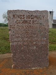
Zively placed seven oak survey posts in Burleson County. One of the matching granite markers has not been found. Of the six that have been found, at least four have been moved short distances. The other two may be at their original locations. Two of the moved markers are still on Zively's route, while the other two are close.
Map of the Old San Antonio Road in Burleson County
[-]Collapse Map [+]Expand Map
|
Marker #: 48
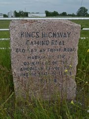
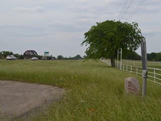
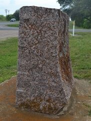
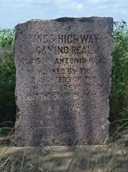
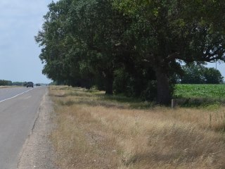
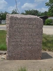
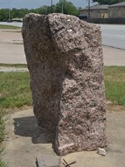
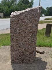
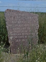
Coordinates: 30.624438, -96.54463 Location: SH 21 south of the Brazos River Relation to Road: 77 feet from south (east) stripe, facing road, W 270° Distance from post: 0.2 mi west (south) of post, on route Dimensions: 31" x 28" x 18" Setting: Asphalt Other Markers/Signage: Yes Visibility: High Accessibility: Excellent This marker was originally placed on the west bank of the Brazos River (or the south bank, since the river runs directly from west to east at this location) between the Old San Antonio Road and the Houston & Texas Central Railroad track at Mosely's Ferry. It has been moved about 0.2 miles south and to the other side of the road. It is about 0.1 miles from the end of the guard rail for the bridge and directly across the intersection of Burleson County Road 221. It is at the end of an asphalt parking area that has been constructed for people to visit the granite marker and the state historical marker sign behind it. The marker is set in a rectangle of asphalt in a patch of grass in between the parking area and a white painted metal fence. A crossover in the median of the divided highway makes the marker easy to access from either direction off of Highway 21. The historical marker sign is for Mosely's Ferry, which provided service across the Brazos from the 1840s to the 1910s. That sign was erected in 1975. A large section from the top left rear corner of the marker is missing, but there is no sign that the marker was damaged in that area. The lettering has been filled in with dark gray paint. Highway 21 does not follow Zively's route precisely in this location, but it is close, and the marker can be considered to be along his route for all practical purposes. Observed on May 10, 2014. |
|
|
Marker #: 49
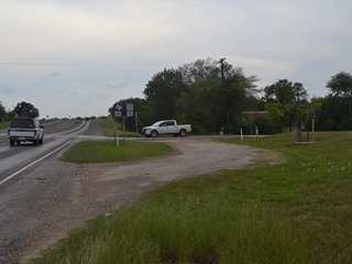
Coordinates: N/A Location: Not found Zively noted that he placed the survey post for Marker #49 "On the West or South bank of the Brazos River at the Shoal Ford and at the N.E. corner of the Beverly A. Porter League." Historic maps confirm that the Old San Antonio Road crossed the Brazos River at the northeast corner of the Porter tract, which can still be seen on modern plat maps, and that it served as the northeastern boundary of that tract. The road still exists, but the section closest to the Brazos River is now on a private oil lease. It becomes a public road, County Road 216, about a mile from the river. Therefore, there is no public access to within a mile of the marker's original location. The marker's current whereabouts are unknown. In Lee County, about 34 miles from Marker #49's surveyed location, there is an extra DAR marker, unaccounted for by Zively's survey. This marker, known on TexasCounties.net as Marker #57B, is probably a marker from elsewhere on the Old San Antonio Road that is missing from its expected location. Marker #49's surveyed location represents the closest OSR survey post from Marker #57B for which the corresponding granite marker is missing. Observed on April 19, 2014. |
 Above: The north end of County Road 216. |
|
Marker #: 50
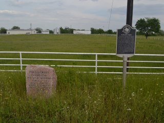
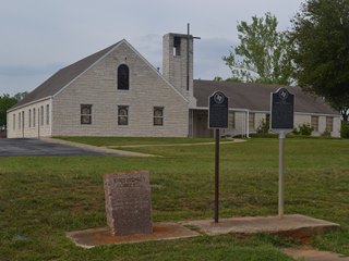
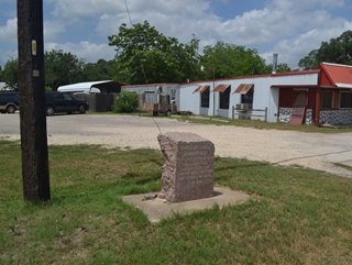
Coordinates: 30.596100, -96.610539 Location: SH 21 in Cooks Point. Relation to Road: 53 feet from north stripe, facing road, S 170° Distance from post: 0.3 mile from post, on route Dimensions: 35" x 25" x 19" Setting: Concrete Other Markers/Signage: Yes Visibility: High Accessibility: Excellent This marker is in front of Cooks Point Brethren Church at the intersection of Highway 21 and FM 1362 South. It is on a raised concrete slab next to two state historical marker signs. The site is highly accessible thanks to a gravel driveway and a concrete sidewalk leading to it. There are historical marker signs on the highway a mile in each direction. There's also a sign near the site, although that sign appears to point to a different driveway, and may be more confusing than it is helpful. The marker is rectangular from the front, but it is irregularly shaped from the sides. The bottom is 19" deep, while the top is only 14" deep. Both the marker and the site are coated with tree residue; the accumulation of this residue inside the lettering makes it easier to read. The historical marker sign placed next to the granite marker is for Cooks Point, the community where the marker now resides. The second sign is for the home site of Judge Andrew S. Broaddus, the leader of a group of colonists who settled in Cooks Point in 1854, and who then later became a Texas legislator and judge. These two historical marker signs were erected in 1969 and 1971, respectively. The granite marker was probably already here when the two historical marker signs were erected, however. The Texas Society DAR's photograph of the site, made between 1995 and 2001, shows the granite marker not on a concrete slab, but resting in the earth, buried deeper than it is today. Note that the lower portion appears much less weathered than the upper portion. This marker was originally located about a quarter of a mile to the northeast, where County Road 213 intersects with County Road 216. Zively placed his survey post for this marker at the location where his two surveyed routes of the Old San Antonio merged back into one route. That one route continued along CR 216 into Cooks Point. Observed on April 19, 2014. |
 Below: Marker #50 site as photographed by the Texas Society DAR, 1995-2001 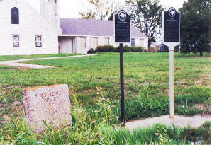 |
|
Marker #: 51
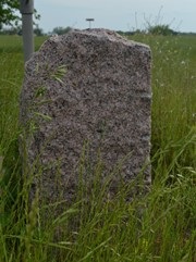
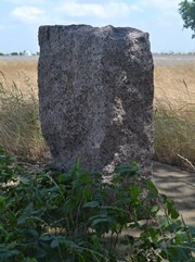
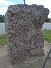
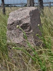
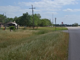
Coordinates: 30.562824, -96.668192 Location: SH 21 northeast of Caldwell. Relation to Road: 39 feet from north stripe, facing road, SE 140° Distance from post: At post Dimensions: 34" x 27" x 11" Setting: Concrete Other Markers/Signage: No Visibility: Low to Medium Accessibility: Good This marker is on State Highway 21 about 2.3 miles northeast of Highway 36 in Caldwell. It is 0.9 miles northeast of FM 2000 and about halfway between County Roads 206 and 208. It is on the north side of the highway, across from Cameron Process Systems. It is in front of a crop field in the shadows of a large tree. There is a wide shoulder for parking. Depending on the time of year and day, the marker might be difficult to spot because of tall weeds and/or shadows. The marker is seated in concrete. It has an irregular-shaped rear side. This marker is at or near its original location. Observed on May 10, 2014. |
 |
|
Marker #: 52
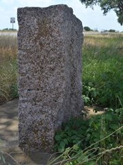
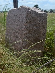
Coordinates: 30.525363, -96.710137 Location: SH 21 in Caldwell Relation to Road: 16 feet from north stripe, facing road, SE 150° Distance from post: 0.2 mi south of post, off route Dimensions: 30" x 25" x 17" Setting: Concrete Other Markers/Signage: No Visibility: Medium Accessibility: Good Zively's route of the Old San Antonio Road through Caldwell exists today as a city street called Old San Antonio Road. State Highway 21 runs through Caldwell about a quarter mile to the south of the historic road. The survey post for Marker #52 was originally placed about 0.2 miles southwest of the railroad track, approximately where Temple Street intersects with Old San Antonio Road. The marker is now located on Highway 21 at the end of Hall Street. The marker is set in concrete in a grassy area beside a utility pole, near the Country Blossoms flower shop. It is not hard to spot if you know where to look, but at the same time, it is inconspicuous and easy to overlook. There is no shoulder or other public parking area, but there are some nearby businesses, including one that was closed at the time of this writing, where it would probably be OK to take a quick stop. Every DAR granite marker has cylindrical grooves along its corners, which were put there during their manufacture. This marker has an additional six smaller bore holes along the right rear edge; these holes are unique to this marker. The marker also has a concave-shaped rear surface and is taller in back than in front. The marker measures 35 inches high in back, but only 30 inches high in front. Observed on May 10, 2014. |
  |
|
Marker #: 53
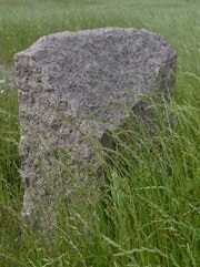
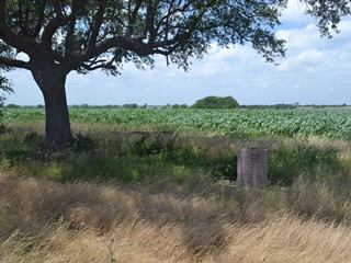
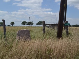
Coordinates: 30.471872, -96.768686 Location: SH 21 southwest of Caldwell. Relation to Road: 76 feet from north stripe, facing road, SE 120° Distance from post: At or near post Dimensions: 40" x 26" x 15" Setting: Dirt and grass Other Markers/Signage: No Visibility: Low Accessibility: Low to Medium This marker is on Highway 21 about halfway between Caldwell and the Burleson-Lee County line, 2.0 miles southwest of FM 908 and 1.4 miles northeast of FM 60. It is on the north side of the highway, halfway between County Roads 115 and 116, which intersect Highway 21 on the south side. It is on the right-of-way beside the driveway for the property at 6508 Texas Highway 21. The marker is just in front of the fence and on top of a ridge. There is a wide shoulder on Highway 21 for parking. It is presumably OK to walk up to the driveway as far as the fence, so as not to have to walk through the ditch and tall grass. The marker itself has no exceptional physical characteristics. Determining the exact original location of this marker is difficult because there are no features on Zively's survey to measure it from except for the distances between it and Markers #52 and #54, which don't quite add up. Nevertheless, it is safe to say that Marker #53 is on Zively's route and that if it is not at its original location - which it may be - it is within 1,000 feet of it. Observed on May 10, 2014. |
   |
|
Marker #: 54
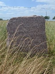
Coordinates: 30.435223, -96.798796 Location: SH 21 northeast of the Burleson-Lee County line. Relation to Road: 49 feet from south (east) stripe, facing road, W 280° Distance from post: Across the highway from post Dimensions: 36" x 28" x 13" Setting: Concrete Other Markers/Signage: No Visibility: Medium Accessibility: Medium This marker is at the intersection of Highway 21 with County Road 130. It is 2.3 miles northeast of East Yegua Creek, which is the Burleson-Lee County line, and 0.6 miles northeast of FM 696. It was originally placed on the north side of the highway - like all DAR OSR markers - but it is now on the south side. It is in front of a pasture fence, set in concrete and surrounded by tall grass. There are no other markers or signs at this site, but only about a tenth of a mile northeast on Highway 21, on the other side of the highway, there is a historical marker sign for the Chisholm Trail, and that site is indicated by highway signage. This aids somewhat in locating the OSR marker. The top of the marker slopes from left to right. A difference in color of the face below the engraving is evidence that the marker used to rest deeper in the ground, probably before it was moved. Other than being moved across the highway, this marker is at its original location. Zively noted that he placed it at the "N.E. Corner of Stephen F. Austin's Five League Survey." The parcel referred to was bounded by the roads that are now Highway 21 and County Road 130. Observed on May 10, 2014. |
   |
- Carson, David - field notes observed and recorded in 2014
- Zively, V.N. - "Field Notes and Detail Map of the Kings Highway", 1916