
The Old San Antonio Road in East Bastrop County
The Old San Antonio Road in East Bastrop County
- Map of the Old San Antonio Road in East Bastrop County
- Route Details
- SH 21 / Paige
- Circle D-KC Estates
- East of Bastrop
- Downtown Bastrop
- The Colorado River
- A Critical Look at Zively's Route
The Kings Highway received little use in eastern Bastrop County after the Texas Revolution, as there were no towns northeast of Bastrop until the railroads came along after the Civil War. Unlike in several neighboring counties, where the Old San Antonio Road served as a land grant boundary and a county line, it had no such application in eastern Bastrop County. Consequently, the route of the Old San Antonio Road was not preserved as well here as it was in neighboring counties. Highway 21 follows Zively's route in some places, but it also skips around among several local roads, with many gaps in between.
A prominent feature of eastern Bastrop County is the Lost Pines forest. This belt of loblolly pines is genetically related to the vast Piney Woods of east Texas, despite being separated from them by nearly a hundred miles.
Map of the Old San Antonio Road in East Bastrop County
[-]Collapse Map [+]Expand Map
Route Details
- State Highway 21 from the Bastrop-Lee County line for 2.6 miles to Gonzales Street north of Paige. This section of Highway 21 conforms exactly with Zively's route. It has two undivided lanes, with narrow shoulders.
- Route lost from SH 21 at Gonzales Street for 0.8 miles to Highway 21 at Old Texas Highway 20 west of Paige.
- SHy 21 from Old Texas Highway 20 west of Paige for 5.1 miles to a point between Lazy Horse Trail and Squirrel Run northeast of Circle D-KC Estates. Exact conformance.
- Route lost from between Lazy Horse Trail and Squirrel Run for 5.0 miles to a point on SH 21 0.2 miles west of Power Plant Rd/County Road 404 and Pinehill Dr/CR 186.
- SH 21 from 0.2 miles west of Power Plant Rd/County Road 404 and Pinehill Dr/CR 186 for 0.4 miles. Here, SH 21 has four lanes, divided by a grass median, and wide shoulders.
- Route lost from SH 21 about 0.6 miles west of Power Plant Rd/CR 404 and Pinehill Dr/CR 186 for 0.6 miles to the northeast corner of Pine View Loop.
- Pine View Loop from its northeast corner for 0.3 miles to its northwest corner. This road is two lanes wide and is unstriped.
- Route lost from the northwest corner of Pine View Loop for 0.5 miles to the small creek crossing on Hoffman Rd just southwest of South Shore Rd.
- Hoffman Road from the small creek crossing just southwest of South Shore Rd for 1.7 miles to State Highway 95. Hoffman Road has a close conformance to the Old San Antonio Road. Hoffman Road has one wide paved lane.
- Route lost from Highway 95 at Hoffman Road for 0.8 miles to the intersection of Hill Street and Spring Street.
- Hill Street from Spring Street for 0.2 miles to Pine Street. Hill Street is two lanes wide, unstriped, with curbs.
- Route lost from the intersection of Hill and Pine Streets for 0.3 miles to the intersection of Water and Emile Streets.
- Water Street from Emile Street for 0.2 miles to Jasper Street at the Colorado River. Water Street is two lanes wide, unstriped, with curbs.
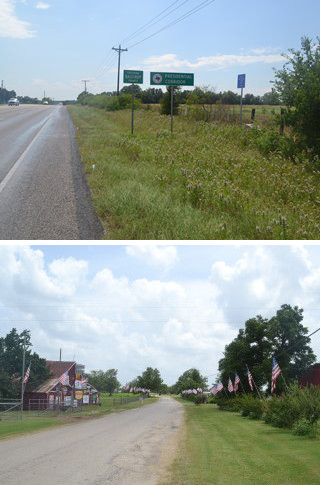
Bottom: Gonzales Street in Paige.
Highway 21 / Paige
During the period of Anglo colonization in Spanish Texas, the Old San Antonio Road served as the northern boundary of Stephen F. Austin's colony. In 1834, part of Austin's colony was broken off and combined with some unsettled territory to the north to form Mina Municipality - the forerunner of Bastrop County. The Old San Antonio Road continued to serve as the northern boundary of Austin County, but inside Bastrop County, it became nothing more than a rarely-used road with no political or jurisdictional significance. The spot where the Old San Antonio Road ceased to be a political boundary is where it crossed the present-day Bastrop-Lee County line. Zively placed the survey post for OSR Marker #60 at this location, and the granite marker is still there.
The Houston and Texas Central Railway completed a section between Brenham and Austin in late 1871. The town of Paige was established on the railroad the next year. It was named for Norman Paige, a civil engineer who had laid out the route of the railroad. A post office was established in 1874. The railroad station was moved in 1876. German immigrants moved in a few years later and set up several cotton gins, factories, and other businesses. The town reported a population of 500 in 1886. It remained robust until after World War II, when the cotton business declined in central Texas. Paige's population has been 275 since 1990. It has several stores and businesses, mostly on US Highway 290.
Zively placed the survey post for OSR Marker #61 at the intersection of the Old San Antonio Road and the railroad, but the highways have changed numerous times, and the original location of the survey post is no longer accessible. The matching granite marker was moved to Paige, possibly when Highway 21 was constructed around 1935 or 1936, or possibly some time between 1940 and 1961 when Highway 21 was rerouted to use a new underpass to cross the railroad.
Highway 21 follows Zively's route for about 5 miles west and southwest of Paige. This route is supported by a 1907 soil survey of Bastrop County. The road must have been a very minor one at the time, for many late 19th-century and early 20th-century maps do not show any road whatsoever between Paige and Bastrop, while others show a road that begins at Paige but peters out somewhere along the way to Bastrop. Most likely, it became smaller and more difficult to follow the further a person traveled from Paige. Zively placed the survey post for OSR Marker #62 in a spot that, according to the 1907 map, was at the last dwelling on the road from Paige to Bastrop. The road may well have become even more obscured beyond that point, because this is where Highway 21 stops following it. Marker #62 has since been moved further south on Highway 21 and is no longer on Zively's route.
Zively marked a site on the east bank of Little Alum Creek which he noted as "Pine Spring. Famous Camping Place." No other record of this site has been found. It does show, however, that the affinity for naming things in eastern Bastrop County after pine trees goes back a long way.
Circle D-KC Estates
For the next five miles after the survey post location for Marker #62, Highway 21 follows a different path than Zively's route of the Old San Antonio Road. The first few miles of Zively's route are supported by the 1907 map of Bastrop County mentioned above, but after that, the only evidence for Zively's route is his own survey.
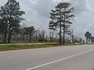
This section of Highway 21 runs alongside Circle D-KC Estates, a residential development begun in the 1980s. The 2010 census recorded 2,393 people living in this unincorporated community.
On 4 September 2011, a fire broke out in Circle D-KC Estates when high winds from Tropical Storm Lee toppled trees into electric power lines. Two other fires soon broke out, one to the north, and the other south of Bastrop State Park. Exacerbated by record heat and drought, these fires combined into a single blaze, which burned for 55 days, killing two people and destroying approximately 1,600 homes and 40 commercial buildings. It was the most destructive wildfire in Texas history. Burnt trees could still be seen along Highways 21 and 71 years later.
Zively placed the survey post for OSR Marker #63 along a no-longer-extant section of the Old San Antonio Road that is now occupied by the Pine Hills subdivision. The granite marker is now in Bastrop, far from this location and well off of Zively's route.
East of Bastrop
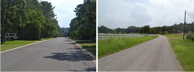
The OSR between Circle D-KC Estates and Bastrop lies between Lake Bastrop and Bastrop State Park. Lake Bastrop was created on Spicer Creek in 1964.
Bastrop State Park was built in 1936 by the U.S. Civilan Conservation Corps. It was expanded in 1979 and now consists of 5,926 acres in the Lost Pines Forest. It offers swimming, camping, and golf. The 12-mile park road connecting Bastrop State Park with Buescher State Park is popular with bicyclists. The entrance to Bastrop State Park is within the Bastrop city limits at the intersection of Highway 21 and Highway 71. Bastrop State Park was heavily damaged in the 2011 fire.
The hilly area in between Lake Bastrop and Bastrop State Park has been lightly developed and contains a mixture of old country houses, newer houses in subdivisions, and cow pastures. Zively's surveyed route of the Old San Antonio Road passes through this area, using a small part of Highway 21 and two local roads, Pine View Loop and Hoffman Road.
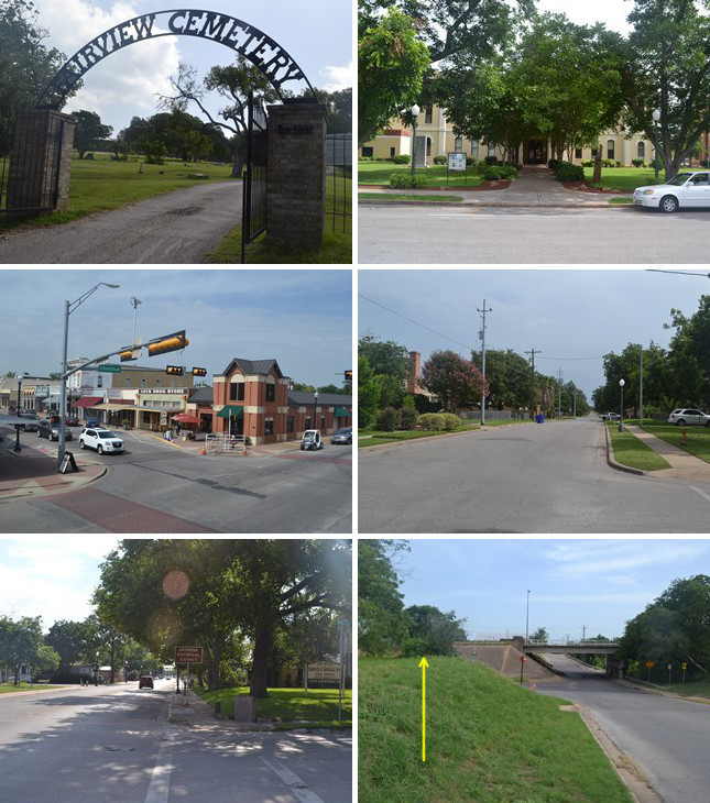
Middle (l to r): The historic district at Main and Chestnut Streets; Hill Street.
Bottom (l to r): Site of OSR Marker #64 at Chestnut and Hill Streets; Site of OSR Marker #65 on Water Street.
Downtown Bastrop
The first European settlement at present-day Bastrop began in 1804, when the Spaniards built a fort named Puesta del Colorado at the Old San Antonio Road's crossing of the Colorado River. At that time, San Antonio and Nacogdoches were the only towns on El Camino Real.
Felipe Enrique Neri was a common Dutch tax collector who immigrated to Spanish Louisiana in 1793 and remade himself as Baron de Bastrop, Dutch nobleman. He moved to San Antonio in 1806 and subsequently embarked upon a political career. He befriended Moses Austin in 1820 and helped him obtain approval for his Anglo-American colonization plan. In 1823, Bastrop himself attempted to establish a German colony on the Colorado River near the former site of the old Spanish fort, but raids from natives kept the colony from taking hold. Later, as a land commissioner in the Mexican government, Bastrop worked harmoniously with Stephen F. Austin in issuing land titles to Austin's colonists.
After Bastrop died in 1827, Austin obtained permission to locate a "Little Colony" of a hundred families in present-day Travis and Bastrop Counties. A handful of settlers went to the site of Bastrop's failed German colony. A town was platted in 1832 and was named Bastrop in honor of the Dutch-born Spanish and Mexican official who had enthusiastically facilitated Anglo-American colonization of Texas. The legislature of the Mexican state of Coahuila y Tejas renamed the town Mina in honor of Mexican revolutionary Francisco Xavier Mina in 1834, but in 1837, the Texas Congress changed the name back to Bastrop.
Bastrop grew despite constant attacks from natives. The county's population was reported as 1,100 in 1835. It was destroyed during the Texas Revolution, then rebuilt. With its proximity to the Lost Pine Forest, Bastrop's early economy centered around the lumber industry. This was augmented in the 1860s and 1870s by iron, coal, cotton, and grain. The cattle business contributed to its growth around the turn of the century. Bastrop's population in 1910 was 1,707. Oil and revived coal and lumber industries flourished in the 1920s through 1940s.
Bastrop reached about 5,000 population in World War II. It declined for several decades afterward, but a recent surge in population, resulting largely from its proximity to Austin, brought the population up from 4,044 in 1990 to 7,218 in 2010.
Much of 19th-century Bastrop still exists today. A fire destroyed the county courthouse and most of the commercial buildings downtown in 1862, but a few homes going back further still survive, including a house built in 1836 or 1837 that was used as an inn and stagecoach stop. Many of the buildings in the downtown historic district, including the current courthouse, were built between 1880 and 1900. The city cemetery at State Highway 95 and Cedar Street dates back to 1832.
According to Zively's survey, the Old San Antonio Road entered Bastrop at the present-day intersection of Hoffman Road and Highway 95. It then followed the west bank of Gills Branch, making its way southwest to present-day Hill Street. Zively placed the survey post for OSR Marker #64 at the corner of Hill and Chestnut Streets; the corresponding granite marker is still at that location. Zively went southward on Hill Street a bit further and then made another turn to the southwest. He marked the Colorado River crossing as just north of the mouth of Gills Branch.
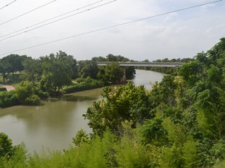
The Colorado River
The Colorado River is the westernmost of the great trio of interior Texas rivers - the other two being the Brazos and the Trinity. During Spanish, Mexican, and Republic times, the Colorado River watershed served as an unofficial western boundary for Anglo settlement of Texas.
As noted in the previous section, the first European settlement in present-day Bastrop County was a Spanish fort named Puesta del Colorado, built in 1804 where El Camino Real crossed the Colorado River. The old Spanish fort was short‑lived and was already defunct by the time colonists came to the area in the 1820s and 1830s. Its location is unknown. The road crossing is believed to have been just north of the mouth of Gills Branch creek, which winds through historic Bastrop and empties into the Colorado River about 0.25 miles south of the modern Highway 21/71 bridge. When the town of Bastrop was established in 1832, the mouth of Gills Branch was used as the southwest corner of the city limits, so even though the creek has moved southward since the early 1800's, its earlier location is easy to find on a city map. According to Zively, the Old San Antonio Road crossed the river 100 varas - or 277 feet - north of the creek mouth. He placed the survey post for OSR Marker #65 at this spot, which should be some 200 to 300 feet south of the intersection of present-day Water and Jasper streets. The matching granite marker has since been moved about three blocks north on Water Street.
To use the Gills Branch crossing, the King's Highway detoured over a quarter of a mile out of its way, then had to make that distance back up on the other side. At first glance, this route seems illogical and impractical. Bastrop County historian Ken Kesselus, however, observes that the Gills Branch location offered two benefits that made it a good point for crossing the river. First, a rock shoal downstream caused sand and gravel to fill in the river bed, providing a firm, shallow location for fording the river. Second, the banks of Gills Branch provided a considerably gentler slope for ascending from or descending to the river compared to scaling the Colorado River's steep, high east bank directly. Thus, the natural benefits of crossing the river at Gills Branch made the added distance well worth it.
Some time after Bastrop's founding, ferry service was opened. One ferry operator was Samuel T. Stone, who settled in Bastrop in 1839. Ferry service at Pine and Chestnut Streets in the 1840s and 1850s allowed for a more direct route across the river. These streets became the main thoroughfares through downtown Bastrop, and the earlier route along Gills Branch became obsolete.
The first bridge across the Colorado River at Bastrop was built at Chestnut Street in 1889. It was replaced by a new bridge in the same location in 1923. The current bridge was built in 1990. The 1923 bridge still exists as a pedestrian walkway.
In 1959, Highway 71 was rerouted around the south side of Bastrop, and a new bridge was built about four blocks south of the bridge at Chestnut Street. The roads from the two bridges converge on the west side of the Colorado River.
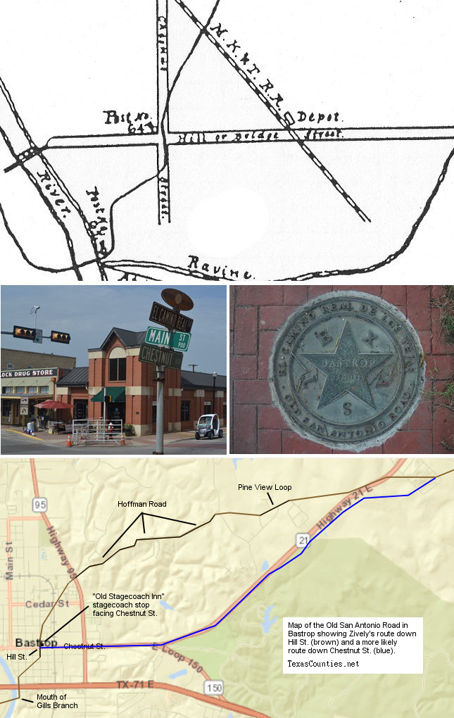
Middle (l to r): El Camino Real street sign on Chestnut St.; One of the 52 bronze "El Camino Real de los Tejas / Old San Antonio Road" medallions placed along Chestnut Street in 2010.
Bottom: Map of Zively's Old San Antonio route through Bastrop down Hill St. compared with a suggested route down Chestnut St.
A Critical Look at Zively's Route
In tracing the route of the Old San Antonio Road through eastern Bastrop County, we must keep in mind that there are no historic maps or documents marking the route from a few miles southwest of Paige to the Colorado River. We can state with confidence that Highway 21 follows the Kings Highway to approximately Squirrel Run Road/CR 153, and we can state with confidence that the historic road crossed the Colorado River at Gills Branch. For the nine to ten-mile stretch in between, however, we are forced to rely on small, isolated bits of historical evidence pieced together with theory and speculation.
While it often makes sense to defer to V.N. Zively, who was 100 years closer to these bits of historical evidence than we are, and trust that his survey is correct, there is a good reason in this instance not to do so: on his sketch of Bastrop, he swapped the names of Chestnut and Hill Streets. The north-south street that should be labeled Hill is "Chestnut Street", and the main east-west street through Bastrop that should be labeled Chestnut is labeled "Hill or Bridge Street." While this could simply be an inconsequential mistake in annotation, it could also be more serious.
Anyone traveling through Bastrop today would get the idea that El Camino Real passed through town east-to-west along Chestnut Street. If the "El Camino Real" street signs at the intersections of Chestnut & Main and Chestnut & Water and the DAR granite marker at Chestnut & Hill weren't enough to make the point, the 52 bronze "El Camino Real de Los Tejas / Old San Antonio Road" medallions added to the sidewalks of Chestnut Street in 2010 leave no doubt as to how local tradition views the route of the Old San Antonio Road.
What if Zively, while attempting to show the Old San Antonio Road's route along Chestnut Street as per tradition, made the mistake of believing that Chestnut Street ran north-to-south instead of east-to-west? Such a mistake would have skewed his survey by 90 degrees, and would have had the Old San Antonio Road exiting Bastrop on the north side of town, when it actually should have exited on the east side. This could explain how he ended up on Hoffman Road.
Our objection to Hoffman Road as the route of El Camino Real is not based simply on Zively's labeling mistake on his sketch. A 1907 map of Bastrop County shows a road to Paige that leaves Bastrop eastward along present-day Chestnut Street/Highway 21. The 1907 map also shows the road now called Hoffman Road, but it doesn't connect with the road to Paige.1 Furthermore, Hoffman Road traverses some of the hilliest terrain in the vicinity. It seems logical that El Camino Real would have avoided those hills and would have instead taken advantage of the gentle topography east of Bastrop.
Another clue could be the historic house known as the Mina - Bastrop Pioneers Home. This house, built in 1836 or 1837, was known in an earlier time as "The Old Stagecoach Inn" because of its role as a stagecoach stop and guest house for travelers on the Old San Antonio Road. Even though this house's address on this now-crowded city block is on Hill Street, the front of the building faces Chestnut Street.2 This implies that the main road passing by the house when it was built - the Old San Antonio Road - was Chestnut Street.
Our map at right presents an alternative route of the Old San Antonio Road in eastern Bastrop county that treats Zively's sketch as invalid due to his mix-up of Chestnut and Hill Streets. It uses a 1907 Bastrop County soil map and a modern topographical map to suggest a route that fits better with the tradition of Chestnut Street as the Old San Antonio Road.
Page last updated: January 12, 2015
1The half-mile segment Zively drew that connects Hoffman Road and Pine View Loop is not supported by the available evidence, and appears to be something he created to solve the problem caused by switching Chestnut and Hill Streets.
2This fact was not evident until the house was restored in 2010.
- Zively, V.N. - "Field Notes and Detail Map of the Kings Highway", 1916
- Carson, David - field notes observed and recorded in 2014
- Texas State Historical Association - The Handbook of Texas Online
- Kesselus, Ken - History of Bastrop County, Texas: Before Statehood, 2005
- Bastrop County Historical Society, "Mina-Bastrop Pioneers Home"