
The Old San Antonio Road in South Bexar County
The Old San Antonio Road in South Bexar County
- Map of the Old San Antonio Road in South Bexar County
- Route Details
- A Critical Look at Zively's Route
- Mission Road
- Espada Road
- Pleasanton Road
The southern half of Bexar County, as seen from the route of the Old San Antonio Road, is considerably less urban than the northern half. The road goes through some older neighborhoods as it connects the four missions from Concepcion to Espada. South of Mission Espada, the route is completely rural as it follows Pleasanton Road on its way out of San Antonio and into Atascosa County.
The road is now completely out of central Texas and is in the drier, flatter, and hotter geography of south Texas.
Map of the Old San Antonio Road in South Bexar County
[-]Collapse Map [+]Expand Map
Route Details
- Mission Road from E Hart Avenue for 1.2 mi to Roosevelt Avenue/Mission Parkway. Mission Road has two automobile lanes, plus bicycle lanes on each side. It has curbs and sidewalks. This segment conforms exactly with Zively's surveyed route.
- Route lost from Mission Road at Roosevelt Avenue/Mission Parkway for 0.3 mi to Mission Road at Huizar Road. The lost segment is on the grounds of Mission San Jose.
- Mission Road from Huizar Road for 1.8 mi to the Stinson Municipal Airport. It has two undivided lanes. Close to the mission and Huizar road, it has curbs and a sidewalk, but the curbs disappear after a short distance, and the sidewalk ends a little further south. Exact conformance. About 300 feet of Mission Road have been overlaid by SE Military Drive/State Highway 13, but the route remains accurate. Military Drive has six lanes that are divided by a center turning lane. It also has curbs. The segment ends approximately at the last building south of the airport entrance, or about 0.1 mi west of Acequia Road.
- Route lost from Mission Road at the Stinson Municipal Airport for 0.4 mi to Espada Road south of Ashley Road.
- Espada Road from south of Ashley Road for 0.6 mi to the SE Loop 410 access road. This is a narrow, unstriped, two-lane asphalt road with no shoulders. Exact conformance. The segment begins about 0.1 mi south of Ashley Road, at the boundary of Espada Park.
- Espada Road at the SE Loop 410 access road on the north side of Interstate Highway 410 for 0.3 mi to Espada Road at Old Espada Road at OSR Marker #86. This segment is severed by I-410. North of I-410, it is designated as an access road for the interstate highway. South of I-410, it is designated as Old Espada Road.
- Espada Road from Old Espada Road at OSR Marker #86 for 0.7 mi to 0.3 mi south of Mission Espada. North of the mission, this segment has two lanes plus a bicycle lane, and is striped. South of the mission, it is a wide one-lane asphalt road. Espada Road now loops around the mission buildings, whereas it used to pass through them. Other than that, this segment conforms exactly to Zively's route. The new section that loops around the mission is designated as Camino Coahuilteca.
- Route lost from Espada Road 0.3 mi south of Mission Espada for 3.6 mi to Pleasanton Road at the east end of Canvasback Lake. A 0.4-mi section of a private ranch road that is labeled Espada Road on most maps is the only remnant of Zively's route.
- Pleasanton Road from the east end of Canvasback Lake for 2.4 mi to the Medina River. Two lanes, asphalt, striped, with unimproved shoulders. Exact conformance.
- Route lost from Pleasanton Road at the Medina River for 0.1 mi to Laredo Road at Leal Street.
- Laredo Road from Leal Street for 0.2 mi to the 90-degree turn at its south end. One-lane asphalt, with no shoulders. Exact conformance.
- Route lost from where Laredo Road makes a 90-degree turn at its south end for 0.5 mi to Pleasanton Road at Farm-to-Market Road 2537. Zively's route follows the line that Laredo Road would make if it were extended straight all the way to Pleasanton Road.
- Pleasanton Road from FM 2537 for 7.5 mi to the Bexar-Atascosa County line. Two-lane striped asphalt, no shoulders. Exact conformance.
A Critical Look at Zively's Route
The placement and course of roads have always evolved over time as travelers' needs have changed. This process of change is illustrated by the various roads on the south side of San Antonio. When San Antonio was founded, it consisted of a mission, a presidio, and a town. The main highway - el camino real - came in from the southwest and went out to the northeast. Within a few years, four more missions were added at intervals on the bank of the San Antonio River, which flowed south-southeast out of the city. The missions were not on the main highway at the time; people traveling to and from the missions came into San Antonio on the El Camino Real, then followed the river down to the missions - first Concepcion, then San Jose, then San Juan, and then Espada. There were short roads between each mission, which connected in a chain to form the Mission Road.
In the mid-to-late 1700s, raids by hostile Apache Indians made it unsafe to travel along El Camino Real. People needing to travel between San Antonio and the Mexican interior used a road closer to the missions and further from Apache territory. This new highway was slightly to the west of the Mission Road, and was much straighter, as it did not need to go all the way into each mission and did not follow the curves of the river. This route became known as the Camino Real de Abaxo, or the "Lower Royal Road," and is represented on a map made by Luis Antonio Menchaca in 1746. Menchaca's Lower Road does not correspond to any one modern road. Between Mission Concepcion and Mission San Jose, it resembles either Mission Road or Flores Street, but the further south it went, the more it resembles Pleasanton Road, as Menchaca showed it passing by the west side of a lake and crossing the Medina River about five miles upriver of its confluence with the San Antonio River.
In time, the Apache threat abated, and the missions were closed. The main route from San Antonio to Mexico City shifted back to the southwest side of town, where the terrain was better, and the distance to cover was shorter. The Lower Road was out of use by 1800. Erasmo Seguin, a prominent resident of San Antonio, wrote in 1838 that it no longer could be seen on the ground, and only old-timers remembered where it used to be.
A map of Bexar County from 1887 shows several historic roads that could have been home to parts of the Lower Road. The early mission roads that followed the San Antonio River bank are labeled "San Jose Road" (Mission Concepcion to Mission San Jose), "San Juan Road" (Mission San Jose to Mission San Juan), and "Espada Road" (Mission San Juan to Mission Espada). These roads are preserved in great part by present-day Mission Road and Espada Road. A road labeled "Corpus Christi Road" followed the San Antonio River west of the mission roads. This Corpus Christi Road is present-day Flores Street and Farm-to-Market 1937. It terminated a short distance past the Medina River. Finally, the 1887 map shows Pleasanton Road, which it labels "Laredo Road."
When Zively surveyed the Old San Antonio Road in 1915, his reference was a diary written by Friar Juan Agustin Morfi in 1778. Morfi traveled from the Rio Grande to the Medina River by way of the Lower Road, then he went to Mission Espada, where his diary ends. Since this diary was Zively's only reference, Zively had no information about the route of the Kings Highway from the Medina River to San Antonio. As the map to the right shows, he ended up patching a route together from sections of Pleasanton Road, the Mission Road, and Laredo Street, cutting across from one historic road to another as required. The two places where he cut across from one historic road to another are probably just his best guess. He placed his survey posts at the beginnings and ends of these cutovers, no doubt to indicate the transition from a known historic road to a route determined by his own guesswork.
In summary, while much of Zively's route on the south side of San Antonio is undoubtedly historic, it is a patchwork of individual road segments that may or may not have been part of the Camino Real de Abaxo depicted by Menchaca and used in the 18th century. Outside of San Antonio, Zively relies on the old San Antonio-Laredo road as being the same road as the Kings Highway.
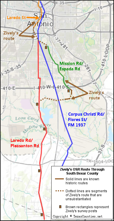
Bottom (l to r): Mission San Jose church, with the "rose window" at the bottom center; Mission Road south of Mission San Jose.
Mission Road
Zively used the historic Mission Road as his basis for the Old San Antonio Road from Mission Concepcion to Mission Espada. This segment begins at the intersection of present-day Mission Road and Hart Avenue, just downstream and across the river from Mission Concepcion. For about a mile, Mission Road preserves Zively's route exactly as it passes through a mature residential area consisting of older houses, apartments, and churches. All of the business are locally-owned, sole-proprietor operations, with no national brands or franchises in sight. The Spanish and Mexican origins of San Antonio are especially noticeable on the city's south side.
Mission San Jose
Mission San Jose, the second mission founded in San Antonio, is located at the end of this section of Mission Road, at its intersection with Roosevelt Avenue. The mission comes clearly into view after the bend at Huff Avenue.
Spain's primary mission focus in the late 1600s and early 1700s was in east Texas, not San Antonio. By 1719, there were six missions in east Texas, which were administered by two different colleges of the Franciscan order of the Catholic church - the Querataran college and the Zacatecan college. In 1719, all six missions closed due to a perceived threat of an invasion by the French from Louisiana. The priests and natives living in the missions retreated to the safety of the brand-new village of San Antonio. The city and its one mission - the Querataran-administered Mission Bexar - became crowded with all of the new arrivals. Father Antonio Margil de Jesús, president of the Zacatecan college, requested and received permission to establish a Zacatecan mission in San Antonio. That mission, named Mission San José y San Miguel de Aguayo, was established on the east bank of the San Antonio River south of Mission Bexar, near its present location. The mission was moved to the west side of the river in 1730, and then moved to its present location in 1739.
Mission San Jose flourished in the late 1700s. Construction on the present church was begun in 1768 and completed in 1777. An exterior wall and watchtowers protected the residents from the Apaches. There were 350 people - missionaries, soldiers, and Indians - living there in 1768, and the mission owned some 5,000 cattle and sheep.
In 1794, Spain began the process of "secularizing" the San Antonio missions - that is, converting them from missions to regular churches. It was a slow process, however; Mission San Jose was not fully secularized until 1824, under the government of Mexico.
Mission San Jose was restored in the 20th century. It was designated as a state park in 1941 and a national park in 1978. Its most well-known feature is the "Rose Window" of the sacristy. It is the only one of the five San Antonio missions that has fully intact exterior walls, so it provides visitors the best visual sense of what a Spanish mission looked like from the inside.
Today, Mission Road stops at Mission San Jose. After a break, it resumes at Huizar Road and continues following the west bank of the San Antonio River. The segment between Mission Concepcion and Mission San Jose resembles the route of the Lower Road on the 1764 Menchaca map discussed in the previous section, but at Mission San Jose, Menchaca shows the road angling away from the San Antonio River, taking a more westerly course. Therefore, Zively's decision to designate Mission Road south of Mission San Jose as "The Kings Highway" is questionable.
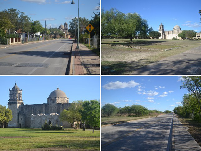
Bottom (l to r): Entrance to San Jose Burial Park; Stinson Airport terminal.
Between San Jose and San Juan
About a half a mile south of Huizar Road, Mission Road made a short zig-zag which has since been overlaid by SE Military Drive/SH 13. Even though continuous travel on Mission Road is now broken by the need to make a left turn and a right turn on a busy, wide state highway, one never leaves Zively's route while doing so.
The only feature Zively marked on his sketch between Mission San Jose and Mission Espada is labeled "Mission Burial Park." This 265-acre cemetery on the east side of Mission Road, just south of SE Military Drive/State Highway 13, was established in 1907, only eight years before Zively's visit. It was San Antonio's first privately-owned cemetery and the first perpetual care cemetery in Texas. The Mission Park company currently has 12 cemeteries and funeral chapels in San Antonio; the original one on Mission Road is called Mission Park South.
Another cemetery, San Jose Burial Park, is on Mission Road just south of Mission Park South. This municipal cemetery is located in a city park that spans both sides of Mission Road. The chapel was built in 1929. The Mission Park company has managed the cemetery for the city of San Antonio since 2011.
Another short distance to the south, bordering San Jose Burial Park and Mission Road, is Stinson Municipal Airport. This land was dedicated as an airfield in 1915, making it one of the oldest airports in Texas. The terminal building was built in 1935. Stinson Field was San Antonio's only airport until 1942, when the present-day San Antonio International Airport was opened as Alamo Field. Today, Stinson is a general-aviation airport that serves private planes and jets, flight schools, helicopter tours, and police and government traffic. It has been home to the Texas Air Museum since 1999.
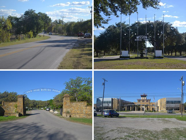
Bottom: The San Antonio River near Mission San Juan in its new channel at its typical level (l) and after several days of heavy rain (r).
Mission San Juan and Berg's Mill
Mission Road bends to the east in front of the airport and crosses the San Antonio River to go to Mission San Juan, which is on the east bank of the river. This same bend is shown on an 1887 map of Bexar County, but Zively's survey of the Old San Antonio Road does not follow it; instead, Zively makes his own shortcut to Espada Road. There is a short break, therefore, where his route is lost.
Mission San Juan Capistrano was originally founded in 1716 in present-day Nacogdoches County as Mission San Jose de los Nazones. It was one of three east Texas missions that relocated to San Antonio in 1731. It suffered a greater amount of Apache attacks than the other missions and was never fully completed. It was secularized in 1794. Only an unfinished church and the lowest layers of the walls remain; the rest of the buildings that stand on the site today were reconstructed in the 1960s. Mission San Juan has been a national park since 1983.
Even after the mission closed, local residents would go to the mission to use its grist mill to grind corn. Several other mills were built on the San Antonio River north of the mission beginning in the 1840s. They served not only as grist mills, but also as sawmills and cotton gins. In 1879, brothers Louis and Henry Berg opened a wool and cotton operation on the river. A town grew in the area, and in 1887, it had a post office named Berg's Mill. In the 1930s, the town of Berg's Mill had two small hydroelectric plants, a train depot, a school, a grocery store, and a movie theater.
One challenge faced by residents of Berg's Mill was the frequent flooding of the San Antonio River. A series of bridges were built across the river and subsequently destroyed. A modern concrete and steel bridge was built in 1914, but it, too, collapsed after a flood in 1946. By the time the city of San Antonio annexed the area of Berg's Mill in the 1950s, the town had dwindled out of existence.
The flooding problem was solved in the 1960s by digging a wide channel for the San Antonio River and rerouting it about 500 feet to the west. A small stream still flows through the original river bed as well. The old 1914 bridge was restored and re-opened to pedestrian traffic in 2013. This bridge and a small stone ruin on the west bank of the old river section are the only remnants of Berg's Mill.
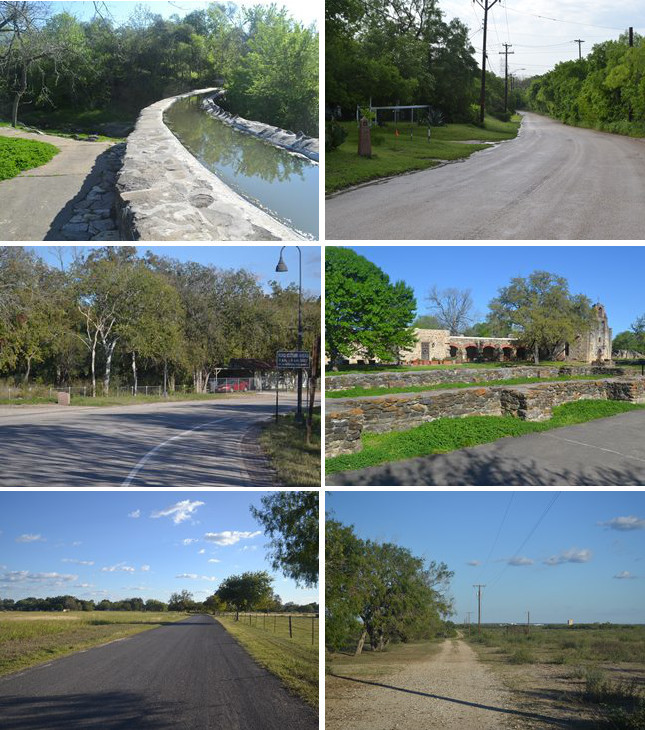
Middle (l to r): Site of OSR Marker #86; church and wall remnants of Mission Espada.
Bottom (l to r): Espada Road south of Mission Espada; the remnant of Espada Road, looking east from FM 1937.
Espada Road
Espada Road is the last leg of the historic road that connected the San Antonio missions. It once began at Mission San Juan, on the east side of the San Antonio River, but it now begins on the west bank of the river. The first few tenths of a mile are now a park road and hiking trail within Espada Park, where visitors can see the only remaining Spanish aqueduct in the United States.
All of the missions relied on water from the San Antonio River. To reduce or eliminate the need for drawing or pumping water from the river, the Spaniards dug acequias - or irrigation ditches - from points upstream to channel the water into the mission and onto its farmlands. The terrain between the San Antonio River and Mission Espada was not level, however, and was crossed by a creek, now known as Sixmile Creek. A Roman-style aqueduct, which was completed in 1745, carried the water over the creek. The Espada aqueduct still serves residents of the Espada area. It is now part of the San Antonio Mission Trail maintained by the National Park Service.
Zively began marking Espada Road as "The Kings Highway" starting at about 0.2 miles north of Rilling Road. Espada Road is narrow and not well-maintained. It goes through a brushy residential area.
Interstate Highway 410 now slices right through Espada Road. A new overpass that deviates from Zively's route allows continuous travel on Espada Road over the freeway. Two small bits of the historic route, one on each side of the freeway, remain in place as freeway access roads.
Zively placed the survey post for OSR Marker #86 on Espada Road at the entrance to Mission Espada. The granite marker has been moved closer to the freeway, where the new overpass merges with the original surface road.
Mission San Francisco de la Espada ("St. Francis of the sword") is one of three missions that relocated to San Antonio from east Texas in 1731. It is the fourth and final successor to the first east Texas mission, San Francisco de los Tejas, which was founded by Governor Alonso de León and Friar Damien Massanet in 1690. Espada was located six miles outside of San Antonio, making it the most distant of the five missions. The original chapel was completed in 1756. The walls were completed in the 1760s.
In 1794, Spain began secularizing the San Antonio missions. Espada's farmlands were divided among the fifteen Indian families who resided there. A community of Spaniards and Indians continued to occupy the mission even after it was fully converted into a parish church in 1824. A raid by the Comanches in 1826 and a fire the same year devastated the community.
In October 1835, the Texian army marched to San Antonio from Gonzales to oust Mexican General Martín Perfecto de Cos. The army camped at Mission Espada for a few days before advancing on to Mission Concepcion.
Espada Road originally went into the mission from the northwest and then made a sharp turn to the south. Today, a road called "Camino Coahuilteca" loops around the mission area. Espada Road resumes on the south side of the buildings. It continues for about a mile into the pastures that once belonged to the mission. Zively included about 0.3 mile of this segment in his sketch of the Old San Antonio Road, then he began his cutover to present-day Pleasanton Road.
Modern maps show a road called Espada Road intersecting with FM 1937 about 1.2 miles south of IH-410. This road is about 1.3 miles long, and apparently served as a back road into Mission Espada for travelers who came up via the Lower Road, so that they did not have to travel all the way into San Antonio and then back out along the Mission Road. Zively included about 0.4 mile of this road on his survey of the Old San Antonio Road. Zively's inclusion of any of this road as part of the Kings Highway is dubious enough; his inclusion of only 0.4 mile of it, and not all of it, is even stranger. This section of Espada Road is now a private ranch road, and is inaccessible to the public.
The next two miles of Zively's route pass through the Mission Del Lago subdivision and around the north side of Mitchell Lake. Here, his route has no correlation to any known historic road. It is obviously just Zively's way of jumping across from Espada Road to Pleasanton Road in as short of a route as possible, without going directly through a lake.
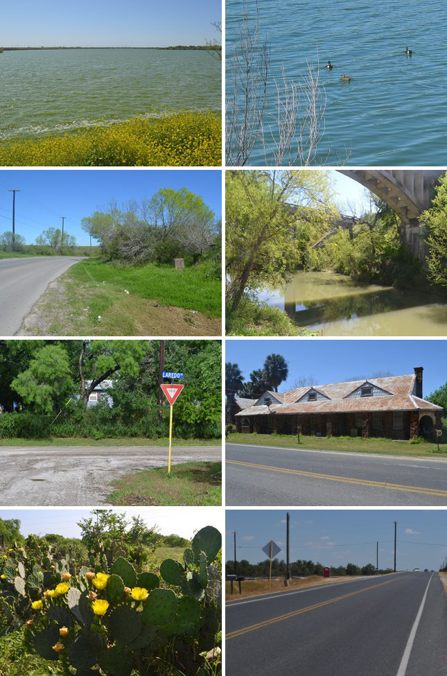
Second row (l to r): Site of OSR Marker #87; the Medina River at Kerr's Ford.
Third row (l to r): Laredo Road south of the Medina River; Jim Watson's home and store at Thelma.
Bottom row (l to r): Prickly pear cacti near Thelma; site of OSR Marker #89.
Pleasanton Road
Zively's route generally follows present-day Pleasanton Road from Mitchell Lake to the Bexar-Atascosa County line. Even though the San Antonio City limits extend past the Medina River, this entire segment is rural.
Mitchell Lake is formed in a low area south of San Antonio by natural drainage. It is not fed by any river or creek. It appears on Menchaca's 1764 sketch of San Antonio and the Lower Road. Early Spanish settlers called it "Laguna de los Patos," or "Lake of the Ducks," and it was used as a duck-hunting spot through the 1800s. It was named Mitchell Lake after Asa Mitchell, who purchased the land that included the lake in 1839. In 1901, the city of San Antonio purchased the lake. The city used it for sewage and waste management until 1972. The following year, it was designated as a wildlife refuge. The nearby Mitchell Lake Audubon Center promotes education and conservation of Mitchell Lake's birds and other wildlife.
As explained in the previous section, when Zively made his survey of the Old San Antonio Road, he cut over from Espada Road to Pleasanton Road, across the north end of Mitchell Lake. He placed the survey post for OSR Marker #87 at the spot where his surveyed route joined the existing road, near the north end of the west side of Mitchell Lake. The route then follows Pleasanton Road along the west side of Mitchell Lake down to the Medina River.
The Medina River flows through southwest Bexar County, crossing through the southern outskirts of San Antonio. During the period of Spanish rule, it was considered the boundary between the provinces of Coahuila and Texas.
The OSR crossed the Medina River south of Mitchell Lake, just downstream of where Leon Creek empties into it. The place where the road crossed the river is labeled "Kerr's Crossing" on an 1887 map of Bexar County and "Kerr's Ford" on Zively's survey. The origin of this name is unknown, but the only prominent Bexar County resident named Kerr was William Price Kerr, who settled at Berg's Mill near Mission San Juan in 1839, operated a mill there, and moved to Medina in 1847.1. There are two highway bridges and one railroad bridge at this location today. The original highway bridge and the railroad bridge were constructed west of the ford in 1910 and 1912, respectively. In 1985, a new highway bridge was built directly over the old ford. The old highway bridge was closed to traffic at that time, but it still stands.
A town named Earle once existed at Kerr's Ford around the turn of the 20th century. A post office operated there from 1887 to 1904. In 1890, Earle had a blacksmith, a general store, a butcher, and a doctor. Zively did not note it on his survey, so it may have already been gone by 1915.
Both Zively's survey and the 1887 Bexar County map show the road making a dog-leg turn to the west after it crossed the river. The road was subsequently straightened, presumably around the same time that the first bridge was built in 1910. A small neighborhood street called Laredo Road partially preserves the original route. Zively placed the survey post for OSR Marker #88 on the south side of the Medina River. His route rejoins present-day Pleasanton Road at FM 2537.
Zively showed a town named Thelma on the railroad at present-day Loop 1604. This town was named for Thelma Watson, the daughter of Jim Watson, who bought an acre of land there in 1904 and built a home, which also became a general store and a post office. Thelma had a very brief history as a stop on the railroad in the 1910s. Watson closed his store in the early 1920s, and the town soon dwindled away. Since Loop 1604's completion through here in 1977, however, businesses have returned to the area. A few of the town's original buildings, including Watson's home and store, still stand.
Country houses line the west side of Pleasanton Road between FM 1604 and the Atascosa-Bexar county line. On the east side, where the railroad runs, is Osburn Materials, a producer of sand, gravel, clay and other materials since 1910. Zively placed the survey post for OSR Marker #89 about a mile south of present-day Loop 1604. The marker was moved about two miles further south, onto Osburn's property, sometime during the 20th century.
Page last updated: November 3, 2015
1This man is not to be confused with either central Texas colonist Peter Kerr or James Kerr, the namesake of neighboring Kerr County and Kerrville.
- Zively, V.N. - "Field Notes and Detail Map of the Kings Highway", 1916
- Carson, David - field notes observed and recorded in 2014
- Carson, David - field notes observed and recorded in 2015
- Texas State Historical Association - The Handbook of Texas Online
- Henderson, Dwight and Lofgren, Ruth - "Mitchell Lake Wildlife Refuge: an Illustrated History," 2013
- Reyes Jr., Jesus S. - "Thelma, Texas"