
The Old San Antonio Road in North Atascosa County
The Old San Antonio Road in North Atascosa County
- Map of the Old San Antonio Road in North Atascosa County
- Route Details
- Old Pleasanton Road
- Poteet
- Atascosa County Road 301
The Old San Antonio Road enters Atascosa County on Old Pleasanton Road, but it quickly departs from that road, so that most of the historic route is lost. The Kings Highway went near, but not through, the towns of Poteet and Jourdanton.
This northern section of Atascosa County is characterized by mushy soil called "black sugar sand." The county was named for the consistency of this soil - "atascosa" means "boggy" in Spanish.
Map of the Old San Antonio Road in North Atascosa County
[-]Collapse Map [+]Expand Map
Route Details
- Old Pleasanton Road from the Atascosa-Bexar county line for 0.8 miles to about halfway between Hickory Lane and Camelot Lane. Old Pleasanton Road is a two-lane country road with an uneven asphalt surface and no striping or shoulders. This section of Old Pleasanton Road has an exact conformance with Zively's route.
- Route lost from Old Pleasanton Road about halfway between Hickory Lane and Camelot Lane for about 12.7 miles to the intersection of County Road 304E and County Road 301 south of Poteet. Where Old Pleasanton Road bends to the east, Zively's route continues straight until about Oak Krest Boulevard, then it bends west. It crosses Farm-to-Market Road 1470 about 0.3 miles east of Red Barn Road. It then parallels Red Barn Road and Holley Road to the Atascosa River. It continues southwest and crosses State Highway 16 approximately at CR 306. It intersects with CR 304E at CR 301. The only modern roads that approximate this segment of Zively's route are Red Barn Road and Holley Road - with the latter being quite close - but even Holley Road is in the wrong position and at the wrong angle to be the same road depicted on Zively's survey.
- County Road 301 from CR 304E for 1.4 miles to its right-angle turn near SH 173. This segment conforms exactly with Zively's route.
- Route lost from CR 301's right-angle turn near SH 173 for about 2.3 miles to Spur 162 about 0.6 miles east of its intersection with SH 97. There are no modern roads in the vicinity of this segment.
Bottom (l to r): Site of OSR Marker #91; a privately-operated memorial to the Battle of Medina.
Old Pleasanton Road
The route of the Kings Highway that connected San Antonio with Mexico City in the late 1700s, which was known as the Lower Road, served a dual purpose in Atascosa County, for it was also the road to Laredo. This leg of the Lower Road was also known as the Laredo Road or the San Antonio-Laredo Road.
In the 19th century, traffic between San Antonio and Mexico City shifted to a route even further west, outside of present-day Atascosa County. The Laredo Road also shifted west at that time. The old Laredo Road/Lower Road fell into disuse. After the town of Pleasanton was founded in 1858, parts of the old highway were repurposed, becoming Pleasanton Road. Zively placed OSR Marker #90 on Pleasanton Road at the Atascosa-Bexar county line.
The segment of Pleasanton Road in Atascosa County was renamed to "Old Pleasanton Road" after U.S. Highway 281 was constructed in the 20th century.
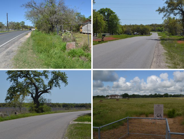
Old Pleasanton Road preserves El Camino Real for less than a mile. Between Hickory Lane and Camelot Lane, Old Pleasanton Road bends to the southeast, whereas Zively's route continued going straight south on its way to Laredo. The photo at right shows where this happens; the road in the foreground is on the historic route, but by the time the road reaches the background, it has curved away from it. The historic route is lost for the next 13 miles.
OSR Marker #91 can be found just past this bend in Old Pleasanton Road. It has been moved over 4 miles from its original location.
Near the location where Zively's route separates from Old Pleasanton Road is a memorial to the bloodiest battle in Texas history - the Battle of Medina. This battle was the decisive end to the first Texas Revolution, which took place in 1813. In 1812, when a climate of revolution was growing in Mexico, Mexican revolutionary Bernardo Gutiérrez de Lara traveled to Washington, D.C. to attempt to enlist U.S. aid for a revolt against Spain. The American government declined to help Gutiérrez, but on his way home through Natchitoches, Louisiana, he did obtain support from Colonel Augustus Magee of the U.S. Army. Magee resigned his commission and helped raise a private army for Gutiérrez. The Gutiérrez-Magee expedition and the so-called Republican Army of the North marched down the Old San Antonio Road, expelling the Spanish Loyalists from one town after another and swelling their ranks with new Mexican, Anglo, and Indian recruits, along with some disgruntled Spaniards. The expedition continued on to San Antonio, despite Magee's death along the way, and defeated the Spanish army. The Republican army declared independence from Mexico on April 17, 1813. Several of Gutiérrez' decisions and policies caused his American supporters to turn against him, however - not the least of which was declaring himself governor and appointing a junta-style government, rather than calling for elections - and on August 6, he resigned and exiled himself to Louisiana. He was replaced by José Álvarez de Toledo.
A Royalist force of 1,830 led by General Arredondo was soon marching northward from Laredo toward San Antonio to retake Texas for Spain. General Toledo led the Republican army - now 1,400 strong, southward on the San Antonio-Laredo Road to meet them. Toledo camped on the north bank of the Medina River on August 17. Arredondo crossed the Atascosa River and camped about six miles south of Toledo's position. The battle occurred the next day - Wednesday, August 18, 1813. Toledo's plan was to ambush Arredondo as he crossed the Medina River, but his men gave their position away in the morning to a Royalist scout. The Republicans then decided to press forward. They engaged a Royalist cavalry company, which retreated and lured them into Arredondo's main force. Exhausted from marching through six miles of sandy soil in the middle of August, and now surrounded by a larger and better-armed enemy, the Republicans were slaughtered. Less than 100 of the 1,400 Republicans escaped alive, while Arredondo lost only 55 men. Arredondo then led a force northward up the Old San Antonio Road as far as Nacogdoches, eliminating the Republican presence from Texas.
The Battle of Medina was so devastating to Texans that they nearly erased it from their memories. Even today, few Texans have heard of it. The site of the battlefield was not recorded in history, and it has not been confirmed by archeological evidence. The state of Texas has erected two historical markers - one in Bexar County, and another in Atascosa County at the intersection of Bruce Road and Old Applewhite Road, about 3 miles west of Old Pleasanton Road. The inscription on that marker testifies to the uncertainty about the battle's location, stating only that the battle "may have taken place in this general vicinity." Another historical marker placed in 2013 by the "Friends of the Medina Battleground," founded by Robert P. Marshall, can be seen on Old Pleasanton Road south of Bruce Road. Visitors to the site can see a granite marker and some plywood cannon replicas in a pasture that Marshall believes is the Medina battlefield. Marshall bases his claim primarily on the calcified soil in the area, which he believes occurred from a large quantity of bones dissolving into the dirt.
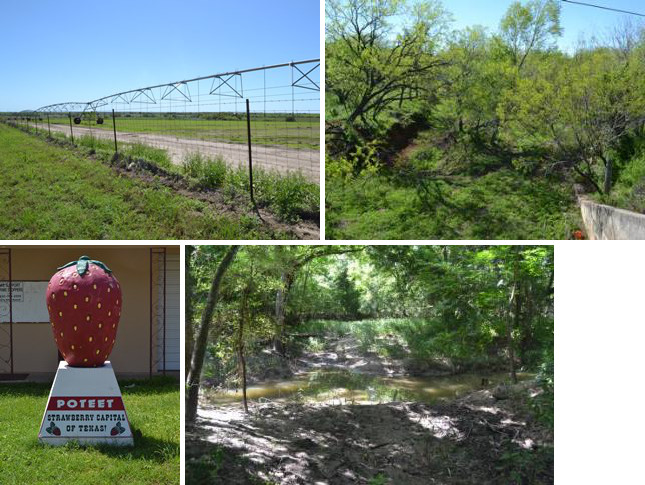
Bottom (l to r): A 1,600-pound concrete strawberry in Poteet; original location of OSR Marker #92 on the Atascosa River.
Poteet
After Zively's route departs from Old Pleasanton Road, it goes south-southwest into an area where there are no modern roads to preserve it. This is a rural area east of the town of Poteet.
Poteet began in 1886 with a blacksmith shop owned by Francis Marion Poteet. In 1896, Henry T. and Ida Mumme settled there and opened a general store. Mumme succeeded Poteet as the town's postmaster and, in 1904, found artesian wells in the area. The discovery of water in this dry area helped the town to prosper. The Mummes began growing strawberries on the irrigated land in 1911. Strawberries soon became a major crop in Poteet. The town has held an annual strawberry festival every year since 1948.
Zively's survey showed that he crossed "La Magdalena Creek" 3.7 miles south-southwest of the point where the OSR left Old Pleasanton Road. That creek would appear to be the one named Galvan Creek today. He placed the survey post for OSR Marker #91 0.9 miles southwest of the creek crossing. By our calculations, the marker would have been placed about 0.1 miles north of Farm-to-Market Road 1470 and 0.3 miles east of Red Barn Road. As noted in the previous section, this marker is now on Old Pleasanton Road.
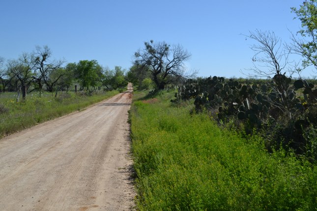
Red Barn Road is about a quarter-mile too far west to be the Old San Antonio Road that Zively surveyed. It is tempting to try to force his route onto Red Barn Road - to stretch and shift his sketch to fit the map, but it does not fit. One reason is because Zively noted that the Kings Highway crossed through a point exactly two miles due east of the town of Poteet, and Red Barn Road is closer than that. Still, Red Barn Road serves well enough as a proxy for the purposes of following in Zively's steps. Today, one will see many strawberry and turfgrass fields irrigated by large center-pivot rigs. These circular crop fields are easily seen in aerial and satellite photographs.
South of FM 476, Holley Road comes closer to matching Zively's route, but it is still a little too far west, and the angle is a little off. Holley Road does bend to the east just before crossing the Atascosa River, however, so Holley Road's river crossing and the historic crossing are very likely one and the same. Zively left the survey post for OSR Marker #92 here, on the north bank of the Atascosa River. Today, the last 0.4 miles of Holley Road closest to the river are on private property and inaccessible to the public.
The Atascosa River was originally considered a creek. After artesian wells were dug around Poteet, the amount of water draining into the creek enlarged it so much that it was upgraded to a river. Today, there is less drainage, such that it is once again more like a creek than a river.
Zively's survey shows the Kings Highway continuing south-southwest from the Atascosa River. It intersects Salt Branch Creek in the vicinity of present-day State Highway 16, about halfway between Poteet and Jourdanton. Zively placed the survey post for OSR Marker #93 near this intersection, on the north side of the creek, a few hundred feet west of the modern highway bridge.
Atascosa County Road 301
South-southwest from SH 16 at Salt Branch, a modern road, Atascosa County Road 301, overlays Zively's route perfectly for 1.4 miles. While the two small right-angle turns at the south end of CR 301 do not exist on Zively's survey, CR 301 does intersect Highway 173 at the same location as his survey indicates, thus confirming that it is an authentic successor to the historic route. Today, it passes through uncleared pastures.
At present-day Highway 173, the road then meandered southward, following the western bank of a small, unnamed tributary to Goose Creek. It intersected with present-day Spur 162 west of Jourdanton, about 0.6 miles east of the intersection of Spur 162 and Highway 97.
Page last updated: June 15, 2015
- Zively, V.N. - "Field Notes and Detail Map of the Kings Highway", 1916
- Carson, David - field notes observed and recorded in 2015