
The Old San Antonio Road in West La Salle County
The Old San Antonio Road in West La Salle County
- Map of the Old San Antonio Road in West La Salle County
- Route Details
- Altito Road
- Cotulla
- Cochina Ranch Road
The Old San Antonio Road used in the late 1700's crossed the Nueces River in western La Salle County. When the town of Cotulla was founded near the same crossing in the late 1800s, a few sections of the historic route were re-used, thus preserving parts of it.
Cotulla and western La Salle County are at the heart of the south Texas oil boom of the early 21st century. The area has gone through some dramatic changes since 2009.
Map of the Old San Antonio Road in West La Salle County
[-]Collapse Map [+]Expand Map
Route Details
- Altito Road from its eastern end at Brown Road for 9.1 miles to its western end at Farm-to-Market Road 624. All of Altito Road is now on private property. At its eastern end, it is an off-road trail, and its conformance to Zively's route may be inexact. The further west it goes, the more passable it becomes, and the more closely it conforms to Zively's route. Altito Road changes to Guadalupe Street at FM 624.
- Guadalupe Street from FM 624 for 0.7 miles to approximately Martinez Street. Guadalupe Street is a simple, 2-lane paved road with no striping or shoulders. The exact location where the OSR leaves Guadalupe Street is uncertain, but up to that point, it conforms exactly to Zively's route.
- Route lost from Guadalupe Street at approximately Martinez Street for 1.4 miles to S Main St/Business 35 at the south bank of the Nueces River. Approximately 0.2 miles of Zively's route appears to follow an existing street, probably Lane Street.
- S Main St/Business 35 from the south bank of the Nueces River for 0.4 miles to the small remnant of Cochina Ranch Road between S Main Street and Interstate Highway 35. S Main Street is two lanes of asphalt, striped, with shoulders. A low wooden post fence is on either side, in place of guard rails. This segment has an exact conformance to Zively's route.
- Cochina Ranch Road from its east end at S Main St/Business 35 for 1.4 miles to a point where the road turns to the northwest. This is a wide two-lane road with no shoulders. It has been bisected by Interstate 35. The small remnant between I-35 and S Main Street is now a private road or driveway. Its intersection with S Main Street has also been altered. Other than these changes, this segment conforms to Zively's route.
- Cochina Ranch Road from the point where it turns northwest about 1 mile west of I-35 for approximately 8.3 miles to the Dimmit-La Salle County Line. This is a wide two-lane road with no shoulders. It is driveable up to the top of La Cochina Hill, but is in terrible condition, as an old layer of pavement has been worn away to the subsurface dirt in so many places that it is essentially now a very windy and bumpy dirt road. It is closed to public traffic at the top of Cochina Hill. Its conformance with Zively's route is difficult to determine. At best, its conformance is inexact, and at worst, there is none.
Altito Road
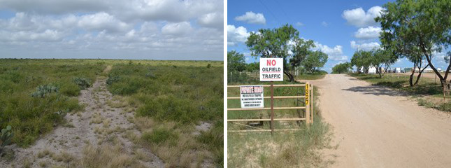
Approximately at present-day Brown Road, Zively's route of the Old San Antonio Road straightened out and ran almost straight west for several miles. An existing road, Altito Road, preserves the historic route for much of this distance. Altito Road is 9.1 miles long, but all of it is on private property and is closed to public traffic.
On its east end, Altito Road is passable only by off-road vehicles. It goes through miles of uncleared ranchland that is used today for deer hunting. This section of road through this stretch of undeveloped, unfenced land is the best place in all of south Texas to imagine Friar Morfi hiking from San Juan Bautista in 1778, keeping a journal along the way, and hoping that his escorts to San Antonio were waiting for him at the crossing on Esperanza Creek.
Zively placed the survey post for OSR Marker #110 on Altito Road about 1.3 miles west of Brown Road. Six miles west of Brown Road, Altito Road makes a turn about 30 degrees northward. Zively placed the survey post for OSR Marker #111 not far from where the road turned.
Altito Road's west end is at Farm-to-Market Road 624 near Cotulla.
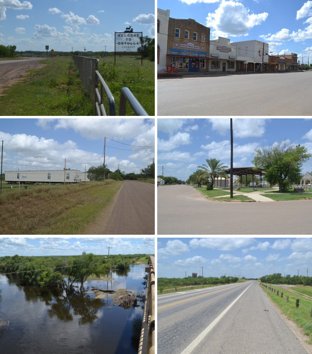
Middle (l to r): A mobile home rental business on Guadalupe Street; city park on Lane Street.
Bottom (l to r): The Nueces River and marshland at S Main Street (after weeks of heavy rain); S Main Street south of the Nueces River.
Cotulla
Cotulla, the seat of La Salle County, was founded in 1881 by Polish immigrant Joseph Cotulla as a stop on the International-Great Northern Railroad. By 1883, it had a post office and won an election to be the county seat. The town grew rapidly, reaching a population of 1,000 by 1890. At that time, it had three general stores, two weekly newspapers, two churches, a school, a bank, a corn mill, a cotton gin, and a saloon. In these early days, three sheriffs and 19 residents are said to have lost their lives in gunfights in the town. One popular legend has it that railroad conductors announced their arrival there to passengers by calling out, "Cotulla! Everybody get your guns ready!"
Despite this dangerous reputation, Cotulla's population continued to grow. The population reached 1,800 in 1914, 3,175 in 1931, and 4,425 in 1954. This was Cotulla's peak in the 20th century. After that, the population declined and stabilized to stay between 3,600 and 4,000 for the next fifty years.
Late in the first decade of the 2000's, advances in hydraulic fracturing technology unlocked billions of barrels of oil and natural gas in the Eagle Ford Shale formation that spans south Texas. The first rig was drilled in La Salle County in 2008, and at this writing, La Salle is the second-most productive of the 28 Eagle Ford counties. Oil drilling and oil production companies chose to place their field headquarters in Cotulla, the largest town in the area. Since then, the city has grown at an astonishing rate. Cotulla's population in the 2010 census was 6,886 - almost double what it was in 2000. It was believed to have at least doubled again by 2013. Property tax collections have also soared, turning Cotulla's city government and its school district from among the poorest to among the richest in Texas almost overnight.
Much of Cotulla's population is temporary or short-term, and much of the city's economy reflects that. Where there were once four hotels, now there are 23. Some businesses offer mobile homes for rent or sale, while others offer space for mobile home parking. Many Cotulla housewives make extra money by offering drop‑off laundry services at their homes.
The old downtown of Cotulla can still be seen on the city's east side, where State Highway 97 crosses the railroad track and turns into Tilden Street. Ben's Western Wear occupies the same location as the original saloon. The T.R. Keck and Sons hardware store has been operated by the same family in the same location since 1893. OSR Marker #112 was moved to this area in 1991.
The route of El Camino Real known as the Lower Presidio Road had been out of use for nearly a hundred years when Cotulla was founded, but remnants of it still existed, and a few local streets were built over those remnants. One such remnant is Guadalupe Street on the southwest side of Cotulla. The Old San Antonio Road entered the city on present-day Altito Road, which changes names to Guadalupe Street after it crosses FM 624. This part of Guadalupe Street is just outside the Cotulla city limits and is still semi-rural. The OSR route turns off of Guadalupe Street before reaching town, somewhere in the vicinity of Martinez Street. Zively drew a "Small Creek" at the point where the road departed from Guadalupe Street. That creek, if it still exists, is not at the right place to be one of the named creeks in the vicinity.
The historic road then cut through the south side of present-day Cotulla on its way to the Nueces River. A short section of it corresponds to one of the northeast-to-southwest city streets on that side of town. Our best estimate is that this was Lane Street between Goft and Thornton Streets. This part of town is now a mature residential area including homes, a city park, a church, and some county buildings.
The Kings Highway approached the Nueces River at a different angle than present-day S Main Street, but met the river at the same crossing. Zively placed the survey post for OSR Marker #112 at the intersection of the Old San Antonio Road and the Nueces River, on the north or east bank of the river.
The Nueces River was the border between the states of Coahuila and Texas during the brief period of Mexican rule over Texas. Its name, given by Alonso de León in 1689, means "river of nuts." The camino real crossed the river at a place where the riverbed is wide and where small channels and pools collect on the south side. Zively labeled this area "Lagoon & Marsh" on his sketch.
South Main Street, also known as Business Interstate 35, crosses the Nueces on a bridge built in 1938. This road preserves Zively's route for 0.4 miles.
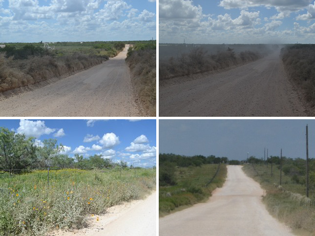
Bottom (l to r): The approximate original location of OSR Marker #114; gate and checkpoint at the top of Cochina Hill.
Cochina Ranch Road
West of Cotulla, toward the Dimmitt-La Salle County line, and south of the Nueces River, there are several hills. Friar Morfi, on his visit in 1778, referred to one hill in particular, "a little higher than the others around it, which is called La Cochina." Morfi also used the term La Cochina to refer to the woodlands surrounding this hill. He wrote that the hill was on the left side of the road, which would have been the north side, since he was traveling eastward. He also commented that "the Apaches killed some men" a few days before his party passed through, and also that "a large number of horses crossed the road."
"Cochina" is one of several Spanish words for "sow," - that is, an adult female pig - but it is more frequently used as a synonym for "filthy." Spanish adjectives are commonly prefixed by the definite articles "el" or "la" to turn them into nouns and nicknames, so "la cochina" could mean either "the pig" or "the filthy one." It is unknown how this hill acquired this name, but it was clearly already in place by 1778, for Morfi uses it as if it were a well-known toponym.
When La Salle County was settled in the late 1800s, the area around this hill was used for ranching. Zively noted "Cochina Hill & Ranch" on his survey of the Old San Antonio Road. He drew the ranch house on the south side of the road and seemed to be indicating that the road crossed the hill near its peak. Zively, therefore, may have followed a more northern route than Morfi did.
A highway map produced by the state of Texas in 1940 shows a road traversing the same vicinity as Zively's route. This road is not labeled on the 1940 map, but the same road exists today and is known as Cochina Ranch Road. At its western end, towards Dimmit County, it is called Briscoe Ranch Road. This road has many more bends and sharp turns than the road Zively drew on his sketch, especially through the lowlands between the hills and the town of Cotulla. There is no question that at least some of the modern road is different than the road Zively surveyed in 1915. Nevertheless, the road does still pass over the highest hill at about its center, and the ranch house shown on the 1940 map was on the top of the hill and the south side of the road, just as Zively depicted it.
The Cochina Ranch was a thriving enterprise in the 20th century. This is obvious from the 1940 map, which shows eight fences and two cattle guards spanning the road, plus a cattle pen and numerous other buildings along it. The ranch reportedly consisted of 40,000 acres in 1960, when it was owned by the Moody Foundation, headquartered in Galveston. Today, the Cochina Ranch offers 4-day deer hunting packages on its 26,000 acres in La Salle and Dimmit Counties.
The Cochina Ranch Road used to intersect with present-day South Main St/Business I-35 - formerly US Highway 81 - about 0.4 miles south of the Nueces River. Today, however, Interstate 35 cuts across this end of the road. The current entrance to Cochina Ranch Road is from a two-way service road on the southbound side of I-35. The small section of the road between I-35 and Business I-35 still exists, but it is on private property and is not contiguous with the rest of the road.
The 1.0 mile of Cochina Ranch Road immediately west of the I-35 service road conforms exactly to Zively's route. OSR Marker #113 was originally placed here, but it has never been located.
After this first mile, interpreting Zively's route becomes complicated. His sketch shows the whole road taking a more southern path than the road currently does or is ever known to have taken. It is also too far south, by almost a mile, to match up with his own notation of "Cochina Hill & Ranch." On our map above, therefore, we have scaled the y-axis of Zively's sketch so that his route is shifted northward. It still does not match the modern road exactly.
OSR Marker #114 was placed about 1.8 miles east of the ranch house that was on the site in 1915, which, as noted above, seemed to be in the same location in 1940. The marker is now more than 9 miles away.
The 1940 map indicates that the Cochina Ranch Road west of Sage Creek was private. Today, the public road stops at the site of the old ranch house at the top of the hill. There are a gate and a checkpoint here.
Page last updated: November 4, 2015
- Zively, V.N. - "Field Notes and Detail Map of the Kings Highway", 1916
- Carson, David - field notes observed and recorded in 2015
- Ben's Western Wear (Cotulla) Texas Hat Museum