
The Old San Antonio Road in East Dimmit County
The Old San Antonio Road in East Dimmit County
Also see The Old San Antonio Road Posts and Markers in East Dimmit CountyThe Old San Antonio Road used in the late 1700's came into Dimmit County from La Salle County a little south of the Nueces River. It went west-southwest toward the site of present-day Catarina. None of the historic road between La Salle County and Catarina has been preserved, and there are no modern roads anywhere in its vicinity - it is all private ranchland. A small piece of the road has been preserved in Catarina.
Map of the Old San Antonio Road in East Dimmit County
[-]Collapse Map [+]Expand Map
Route Details
- Route lost from Cochina Ranch Road/Briscoe Ranch Road at the Dimmit-La Salle County line for approximately 14 miles to the eastern side of Catarina.
- San Hilario Ave on the south side of Catarina beginning at Isabella St. and continuing for 5 blocks to Esperanza St. There is a higher likelihood that this street matches Zively's route on the east side of Highway 83. San Hilario Ave. is one lane of broken asphalt with no striping, curbs, or shoulders.
- Route lost from San Hilario Ave at approximately Esperanza St. in Catarina for 1.2 miles to the western city limits of Catarina on Cemetery Rd.

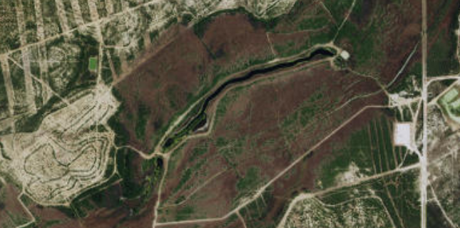
Below: Satellite image of San Roque Lake.
Through the Lomerias
Near the Dimmit-La Salle County line, a local road called Cochina Ranch Road that preserves or approximates the Old San Antonio Road in western La Salle County begins to go off on a substantially different course from the route of the Old San Antonio Road surveyed by V. N. Zively. Zively showed the Kings Highway heading in a south-southwest direction toward the town of Catarina. There are no public roads in this area today. The only direct route into Catarina from La Salle County is Farm-to-Market Road 133, which opened in 1945 and is miles away from the Kings Highway.
Friar Juan Morfi traveled on this segment of El Camino Real in 1778. He described the country between Catarina and Cochina Hill in present-day La Salle County as consisting of lomerias, or low hills, with a few groves of mesquite, prickly pear cactus (nopal), and pools of water. He also noted this area as the eastern limit of the agave (maguey), or century plant. Here, Morfi wrote, "the land changes to a cinnamon color."
When Zively surveyed the Kings Highway in 1915, he was attempting to follow the same route used by Morfi, but since none of the route has been preserved, and because Morfi gave so few waypoints, it is hard to know how well he succeeded. Even trying to follow Zively's route is difficult; his sketches require substantial stretching and rescaling in order to fit the known waypoints.1
Zively placed the oak survey post for OSR Marker #115 on the Dimmit-La Salle County line. About 3 miles west of there, he noted the "Pools of Romana." There is a small, unnamed creek near this location. He placed the survey post for OSR Marker #116 about two miles further west.
The next major stream along the road is San Roque Creek, which flows northeast and empties into the Nueces River. A dam on the creek has created a narrow, string-shaped lake almost a mile long. Zively noted the creek and lake on his sketch and indicated that the road crossed on the south, or upstream, side of the lake. This is where he placed the survey post for OSR Marker #117.
Zively's route crossed the Asherton & Gulf Railroad about 1½ miles east of Catarina. This railroad was constructed in 1909 and abandoned in 1958. Its right-of-way is still clearly visible in satellite photos.
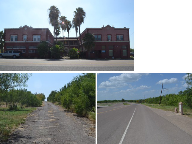
Bottom (l to r): San Hilario Avenue; site of OSR Marker #118.
Catarina
The town of Catarina was named after the Catarina Ranch, which was founded in 1881 by Ohio iron magnate David Sinton. The ranch, in turn, was named after Catarina Creek, which was named by Spanish explorers or missionaries more than a hundred years earlier. Friar Morfi stopped at the "aguaje of Santa Catarina," or "water-hole of Saint Catherine," during his visit here in 1778.2 Sinton died in 1900, leaving his entire estate to his daughter, Ann, who was married to Charles P. Taft, the brother of future U.S. President William Howard Taft. Their 235,000-acre estate in south Texas became known as the Taft-Catarina Ranch.
The Sintons and Tafts were absentee owners of the ranch, leaving its operations in charge of Joseph F. Green. Green built an ornate, three-story house on a hill, fitting it with oversized bathtubs in case the famously overweight president should ever decide to visit. Green also negotiated an easement with Asher Richardson, who had plans to extend a railroad from Artesia Wells to Asherton. In return for an easement through the ranch, Richardson agreed to allow Green to build a depot and cattle pens on the railroad. The railroad was completed in 1910. Green then moved the ranch headquarters to the railroad, about a half a mile north of the three-story house.
Green and others continued to aggressively develop the ranch and town of Catarina, adding a post office, a small schoolhouse, and some other buildings, bringing in electricity and telephones, and making substantial investments in agriculture. In 1929, Catarina had over 1,000 residents. Only two years later, however, the Great Depression forced many of its business to close, and the town's population was reduced to 592. It continued to decline in the succeeding decades. The railroad was abandoned in 1958, and the tracks were subsequently removed. In 1981, former Texas Governor Dolph Briscoe purchased the long-vacant, dilapidated, Taft House and moved it to his ranch for it to be restored. By 1990, only 45 people were left in Catarina.
Catarina has experienced mild growth in the 21st century, thanks to the south Texas oil boom. Its population in 2010 was 118. The historic Palm Hotel still exists at its original location.
Zively showed the Kings Highway passing from east-to-west through the south side of Catarina. His sketch seems to show that the road crossed just south of the hilltop where the Taft House would later be built. One of Catarina's streets, most likely San Hilario Avenue, was probably laid out over the old camino real. Like most of Catarina's streets, there is little on San Hilario Avenue today except for some sparse housing. The vacant lots are covered with mesquite and prickly pear brush.
Zively placed the survey post for OSR Marker #118 about a mile southwest of Catarina. That marker is now on U.S. Highway 83, across from the Palm Hotel.
Page last updated: August 18, 2015
1Ideally, we could follow Zively's route simply by overlaying his sketches onto a modern map and enlarging or reducing them until everything aligns perfectly. In most of east and central Texas, this is not difficult to do. In south Texas, however, especially in Maverick, Dimmit, and western La Salle Counties, it is impossible to use Zivley's sketches in this fashion. To be useful at all, many scaling adjustments must be made to them. It isn't good enough for the road to connect two known waypoints; it also has to do it in a sensible fashion, by not unnecessarily crossing the same creek multiple times, for example, or by not curving out of its way to cross directly over the crest of a hill. Despite the many liberties we had to take with some of Zively's sketches to make them fit the local topography, we feel that our map of Zively's route in eastern Dimmit County is not only realistic, but is also accurate to within a half a mile.
2Other, more colorful explanations of how the town got its name can safely be dismissed as mere storytelling.
- Zively, V.N. - "Field Notes and Detail Map of the Kings Highway", 1916
- Carson, David - field notes observed and recorded in 2015