
The Old San Antonio Road in West Dimmit County
The Old San Antonio Road in West Dimmit County
- Map of the Old San Antonio Road in West Dimmit County
- Route Details
- Bonito Creek
- Faith Ranch
- San Pedro Ranch
The Old San Antonio Road crosses through several large ranches in southwestern Dimmit County. Its route is partially preserved by private ranch roads.
Map of the Old San Antonio Road in West Dimmit County
[-]Collapse Map [+]Expand Map
Route Details
- Route lost from the original location of OSR Marker #121 on the Briscoe Catarina Ranch for approximately 8 miles to the eastern end of a private road on the Faith Ranch.
- Private road on the Faith Ranch. This is a basic backcountry trail that has been graded for vehicular traffic. For 5.4 miles, it has a high degree of conformance to Zively's route.
- Route lost from the western end of a private road on the Faith Ranch for 6.8 miles to the Dimmit-Maverick County line. A few short sections of this segment are preserved by private ranch roads, but most of this segment is lost.
Bonito Creek
Toward the west end of the Briscoe Catarina Ranch, Zively noted that the Kings Highway passed through two "Lomas Bonitas," or "pretty hills." He placed the survey post for OSR Marker #121 about 0.8 miles west of the hills and about a tenth of a mile north of Bonito Creek.
For the preceding 10 miles, the route of the Kings Highway had been nearly a straight line going south-southwest out of Catarina. At post #121, however, Zively showed the road making a long deviation to the south, which added more than two miles to the route. There are two reasons why travelers would need to make such a conspicuous deviation from their intended route: elevation and water. That is, if going in a straight line would make travelers have to climb a tall hill or cross a deep chasm, or leave them without access to water, they might opt to go out of the way for a more level route, or one where they could find water. Here, in the Bonito Creek lowlands, both factors may have played a part, but the need for water was probably more important. There are some steep hills and ridges to cross over here that could make traveling in a straight line difficult, but navigating around them would not require such a large deviation. The only reason to deviate as far off course as Zively indicated is to take advantage of several natural ponds or "tanks" that can be found south of Bonito Creek. Zively noted one of them, which he called "Toya Tank," on his sketch. That same pond is called "Vaca Tank" on a modern map.
Zively's route turns northwest at Vaca Tank. It crosses the fenceline between the Briscoe Catarina Ranch and the Faith Ranch and climbs a ridge that is about 80 feet high. Zively placed the survey post for OSR Marker #122 on top of the ridge.
The authenticity of Zively's route from posts #121 to #122 is questionable for several reasons. First of all, none of it is preserved - not even in traces. On the other hand, there is an old ranch road that traverses this same ridge and crosses Bonito Creek without making such a long detour. That road does not pass by any streams, ponds, or other sources of water, which is the only advantage Zively's route offers. Zively, however, was supposedly following the 1778 diary of Friar Juan Morfi to re-create the Kings Highway, and Morfi did not record any water between San Lorenzo Creek and Catarina Creek. The headings Morfi recorded in his diary also do not support Zively's route. Morfi - who was traveling on El Camino Real in the opposite direction from us - described the route from San Lorenzo to Catarina as five leagues east-northeast, one east, and four east-northeast. Clearly, this is not the same route surveyed by Zively.
In summary, while the route Zively surveyed across the Bonito Creek lowlands is feasible, especially if having access to water is all-important, the absence of historical and physical evidence for it casts doubt upon whether there actually was a road here in the 1700s, much less whether it was a part of the Old San Antonio Road.
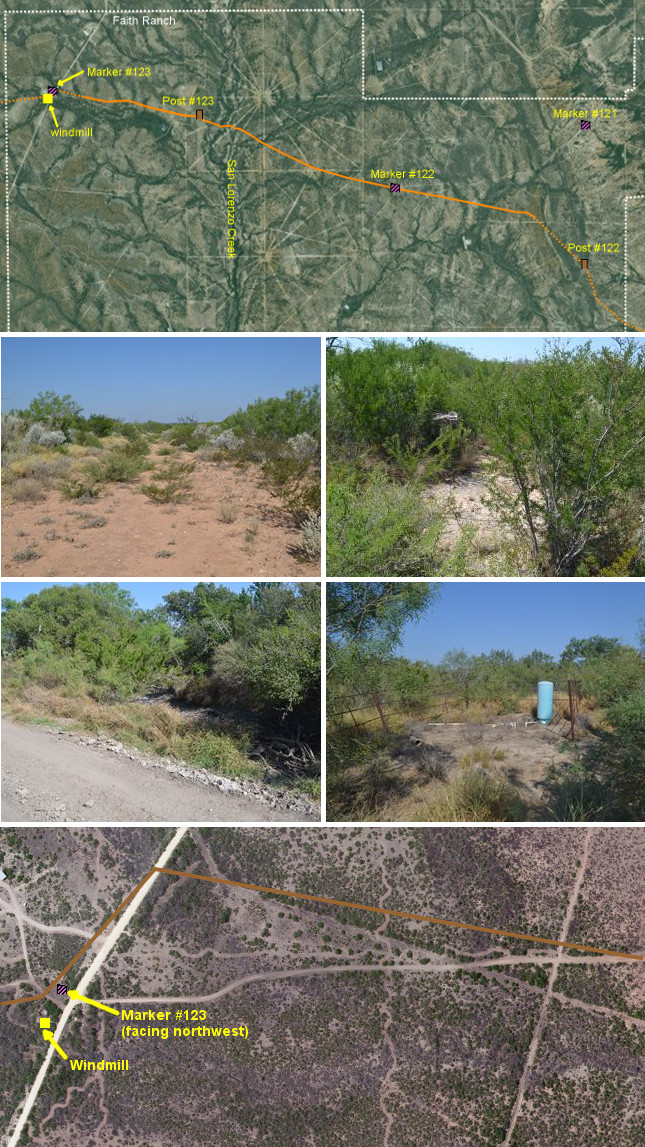
Second row (l to r): El Camino Real on the Faith Ranch; Site of OSR Marker #122.
Third row (l to r): The San Lorenzo Creek crossing; site of the windmill on Faith Ranch Road.
Bottom: Satellite photo showing Zively's route in relation to OSR Marker #123, the windmill, Faith Ranch Road, and the ranch road graded in 2009.
Faith Ranch
About 8 miles of Zively's route of the Kings Highway are now within the Faith Ranch. The Faith Ranch was founded by Wesley West in 1960. The land had previously been part of the Chupadera Ranch, owned by West's father, James. M. West Sr. Most of the Faith Ranch's 40,000 acres are in southwestern Dimmit County, with small portions in southern Maverick County and northwestern Webb County. The ranch is still collectively owned by Wesley West's descendants. Since 1980, it has been managed by his grandson, Stuart W. Stedman. Once a commercial deer hunting destination, the ranch has served primarily as a family retreat since 2003. There are also some oil leases on it.
There are no areas on Faith Ranch that are accessible to the general public or unexpected visitors. Our visit in 2015 was made by a special arrangement.
In 2009, Stedman graded a road on the Faith Ranch in an attempt to replicate El Camino Real as closely as possible. He used aerial photographs made in the 1960s to locate scars and brush trails on the ground. About 4.3 miles of the road graded in 2009 conforms closely or exactly to Zively's route. Another 1.2 miles of Zively's route is preserved by another ranch road that presumably pre-existed the 2009 project.
As the previous section explains, the survey post for OSR Marker #122 was originally placed on top of a ridge on the east end of the Faith Ranch. The section of Zively's route leading up to that point from the plains below is not preserved, and its authenticity as an actual route of El Camino Real is dubious. By the same token, the next 0.8 miles of Zively's route northwest of the post #122 location are not preserved and are equally questionable.
The preserved portion of the Kings Highway begins 0.8 miles past post #122 (see the satellite photo, above right). For the next 1.2 miles, a private ranch road matches Zively's route with a very high degree of accuracy.
At the end of the 1.2 miles, there is a fork where this road merges with the road graded in 2009. The 2009 road takes a different route eastward down the ridge and over the Bonito Creek lowlands. OSR Marker #121 was moved to this other route long ago by unknown persons and for unknown reasons; its presence here was one of the main reasons Stedman graded the road to this location. Overall, this 2009 road may be a truer representation of the camino real and the route described in Morfi's diary than Zively's route is.
The fork where the ranch road graded in 2009 merges with Zively's route begins a 4.2-mile section where the new ranch road conforms quite closely to Zively's route. There are a few discrepancies between the two routes, but they are minor, never amounting to more than 100 feet. One such discrepancy is at the current location of OSR Marker #122. The ranch road passes by it to the north, whereas Zively's route passed by its south side. This is the only place on the 4.2-mile section where Zively's route can be seen alongside the graded ranch road on a satellite photo.
About 1.6 miles west of Marker #122 is San Lorenzo Creek. Friar Morfi stopped here for the evening during his journey in 1778. It was Morfi's first campsite since leaving the Rio Grande. Zively placed the survey post for OSR Marker #123 0.4 miles west of the creek.
The new ranch road ends its conformance with Zively's route about 2,000 feet east of Faith Ranch Road, which is the main access road from the ranch to the town of Carrizo Springs. There are two points of interest on Faith Ranch Road. One is OSR Marker #123, which was moved here decades ago from its original location near San Lorenzo Creek. The marker is on the west side of the road, but notably, it is oriented to the northwest, facing away from Faith Ranch Road and toward Zively's no-longer-extant route (see the satellite photo, right). This strongly suggests that the marker was moved here either by someone who consulted Zively's survey or at a time when the historic route was still evident on the ground.
The second point of interest here is the site of an old windmill. The windmill tower itself no longer exists, but its water well does, and parts of its foundation can still be seen sticking up out of the ground. This is one of two windmills Zively noted on his 1915 survey. These windmills serve as important known, fixed reference points for Zively's survey, and they greatly enhance our ability to interpret his survey in Dimmit and Maverick Counties. Zively showed the road turning at the first windmill and going west toward the second one, which is now on the San Pedro Ranch.
San Pedro Ranch
Approximately the last six miles of Zively's route in Dimmit County are on the San Pedro Ranch. Hugh A. Fitzsimons Sr. of San Antonio purchased this 24,000-acre ranch in 1932. It is now owned by two of his great-grandchildren, Joseph B.C. Fitzsimons and Pamela Fitzsimons Howard. The ranch produces beef cattle and operates commercial deer leases. It is inaccessible both to the general public and to people doing historical research on El Camino Real.
The route of the Kings Highway surveyed by Zively comes into the east side of the San Pedro Ranch from the Faith Ranch. The road passed by two windmills - one on the Faith Ranch, and one on the San Pedro. The road then went to the natural spring that is at the heart of the San Pedro Ranch. Zively placed the survey post for OSR Marker #124 at the spring. According to his sketch, the road turned to the northwest at the spring, then, after about 0.8 miles, straightened back out, going generally westward until reaching the Dimmit-Maverick County line.
Based on a study of satellite images, it appears that some short sections of Zively's route in the area of the main ranch house are preserved by private roads, but the majority of the route has been lost.
Page last updated: September 21, 2015
- Zively, V.N. - "Field Notes and Detail Map of the Kings Highway", 1916
- Carson, David - field notes observed and recorded in 2015