
The Old San Antonio Road Posts and Markers in West Dimmit County
The Old San Antonio Road Posts and Markers in West Dimmit County
- Map of the Old San Antonio Road in West Dimmit County
- Marker #121
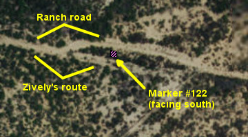
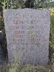
- Marker #122
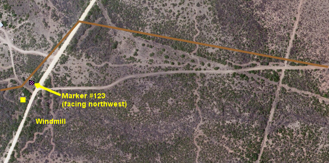
- Marker #123
- Marker #124
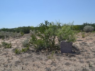
Zively placed ten oak survey posts for the Old San Antonio Road in La Salle County. Three of them were placed in the southwest part of the county shown on this map. All three have been moved, but are still on the historic route. Additionally, a marker originally placed in south central Dimmit County has been moved here. All four of the markers are on private property.
Map of the Old San Antonio Road in West Dimmit County
[-]Collapse Map [+]Expand Map
|
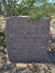
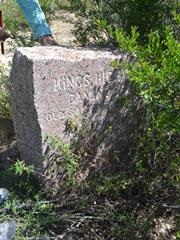
Marker #: 121
Coordinates: 28.26567, -99.91798 Location: Faith Ranch, west of Bonito Creek Relation to Road: Not applicable, oriented N 340° Distance from post: 3.4 mi west of post, off route Dimensions: 28" x 28" x 12" Setting: Dirt and brush Other Markers/Signage: No Visibility: N/A Accessibility: N/A This marker is on Faith Ranch, close to the northeast corner of the ranch. The marker is beside a mesquite bush. It is clean and in good condition. As the marker is on private property, it is inaccessible to the general public. According to Zively's sketch, this marker should be about 3.4 miles east of its current location, on the Briscoe Ranch. It has been at its current location since at least the time of the Texas Society DAR's visit circa 1995. The manager of Faith Ranch stated in 2015 that the marker had been moved in the past, but it was moved from a different location on Faith Ranch. It's possible that it was moved from its survey location long ago, before the Briscoe or Faith Ranches were established. At its current location, this marker is about a mile north of Zively's surveyed route. Observed on August 8, 2015. |
|
|
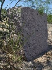
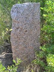
Marker #: 122
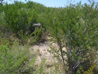
Coordinates: 28.256849, -99.963027 Location: Faith Ranch, east of San Lorenzo Creek Relation to Road: 25 feet from south edge, oriented S 190° Distance from post: 3.0 mi northwest of post, on route Dimensions: 34" x 25" x 15" Setting: Dirt and brush Other Markers/Signage: No Visibility: N/A Accessibility: N/A This marker is in the middle of Faith Ranch, about 25 feet from a private ranch road that the owner graded to approximate El Camino Real. It faces south, away from the ranch road, and can barely be seen from it. Its face and right side are covered in brush. When the brush is pulled back, the marker's face is, surprisingly, very clean. As the marker is on private property, it is inaccessible to the general public. According to Zively's sketch, this marker should be about 4½ miles east of San Lorenzo Creek. It is actually about 1½ miles east of the creek, suggesting that it has been moved some three miles from its original location. The manager of Faith Ranch stated in 2015 that it has been at this spot longer than he or anyone else could remember. Based on the photograph made by the Texas Society DAR during their visit circa 1995, it may have been in the same place then as it is now. The DAR did note that it faced south. The coordinates given by the DAR are way off - they give it a further 0.6 miles northwest of here and only a mile east of San Lorenzo Creek - but inaccuracies such as this are, sadly, quite common in their notes. The DAR's notation that it was originally placed "West of San Lorenza Creek" is an obvious error. The current ranch road deviates off of Zively's route slightly to the north here. The surveyed route, which can still be seen on satellite images, actually passes south of the marker. Therefore, while the marker faces away from the ranch road, it does correctly face the surveyed route. Why this marker is so far from the surveyed location, and when it was placed here, will probably never be known, but its close proximity to Zively's surveyed route for the Kings Highway and its proper orientation suggest that it was moved either by someone familiar with the survey or at a time when the route was still passable. Observed on August 8, 2015. |
|
|
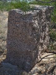
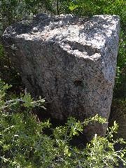
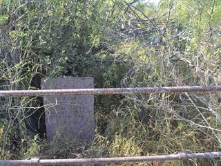
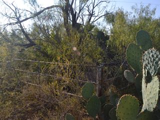
Marker #: 123
Coordinates: 28.270116, -100.019254 Location: Faith Ranch Road south of the main gate Relation to Road: 60 feet west of road, oriented NW 330° Distance from post: 1.9 mi northwest of post, on route Dimensions: 35" x 25" x 10" Setting: Dirt and brush enclosed by fence Other Markers/Signage: No Visibility: N/A Accessibility: N/A This marker is on the main road into the Faith Ranch, approximately halfway between the main gate and the ranch house. This is private property and is not accessible to the public. We visited the marker with the owner's permission. The marker is under a large tree, inside a pen made of metal sucker rod from a well. There is a lot of brush inside the pen, making the marker difficult to see even from a short distance away. The tree can be seen from the ranch road, but the pen and marker cannot. The engraving on the marker is partially filled in with tree residue. This marker was originally surveyed nearly two miles east-southeast of here, about 0.4 miles west of San Lorenzo Creek. It was in its current location, inside the same pen, when the Texas Society DAR visited it for their 1995-2001 OSR marker rededication project. The manager of Faith Ranch stated that it has been at this spot longer than he or anyone else could remember. It was presumably moved to this spot many decades ago to be closer to the ranch road. The marker is about 150 feet north of the former site of an old windmill. Zively marked this windmill on his sketch and noted the Kings Highway turning in front of it. The marker, therefore, although moved from its original location, is still on Zively's route. Today, there is no trace of Zively's route in this vicinity, either on the ground or discernible from satellite images. The fact that Marker #123 is not only so close to his route, but it also oriented to face a road that is no longer there, is strong evidence that it was either moved long ago, when the historic route was still visible, or it was moved by someone who consulted Zively's survey. Observed on August 8, 2015. |
|
|
Marker #: 124
Coordinates: 28.2727, -100.07275 Location: San Pedro Creek crossing on San Pedro Ranch Distance from post: 0.3 mi south of post, off route Dimensions: Not available Setting: Concrete Other Markers/Signage: No Visibility: N/A Accessibility: N/A This marker was placed near San Pedro Creek at a place where the road made approximately a 90-degree turn. Our analysis of Zively's sketches suggest that it was just east of the present-day headquarters for the San Pedro Ranch. According to the Texas Society DAR, who documented Marker #124 for their 1995-2001 rededication project, the marker was "at the San Pedro Creek crossing below the ranch headquarters and East of the springs." The coordinates given in the DAR's notes do correspond to a location matching this description. It is about 0.3 miles south of the marker's surveyed location. In their photo, the marker is in a very old-looking concrete setting. We were unable to obtain the property owner's permission to document Marker #124 for this project. |
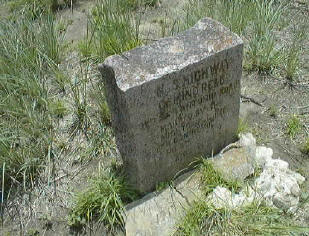 The Texas Society DAR's photograph of Marker #124, made between 1995 and 2001. |
- Carson, David - field notes observed and recorded in 2015
- Zively, V.N. - "Field Notes and Detail Map of the Kings Highway", 1916
- Texas Society Daughters of the American Revolution - Old San Antonio Road DAR Marker Information Site