
The Old San Antonio Road Posts and Markers in San Augustine County
The Old San Antonio Road Posts and Markers in San Augustine County
Also see The Old San Antonio Road in San Augustine CountyZively placed four oak survey posts in San Augustine County: one east of the town of San Augustine, one in town, and two west of town. All four of the markers have been located, and all four are publicly accessible. The one east of San Augustine is at its original location, and one of the markers west of town is either at its original location, or very close to it. The other two have been moved a short distance. All four markers are on Zively's route.
Map of the Old San Antonio Road in San Augustine County
[-]Collapse Map [+]Expand Map
|
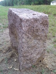
Marker #: 6
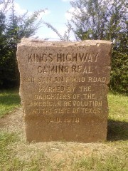
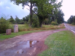
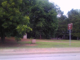
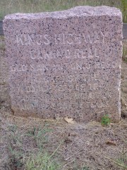
Coordinates: 31.511393, -94.0488556 Location: On Highway 21 east of San Augustine Relation to road: 32 ft from north stripe, facing road, SW 200° Distance from post: At post Dimensions: 29" x 25" x 12" Setting: Grass/dirt Other Markers/Signage: Yes Visibility: High Accessibility: Excellent Zively placed this survey post near the home of Elisha Roberts, a prominent citizen of San Augustine County around the time of the Texas Revolution. The house is no longer there, but its location is marked by a state historical marker that was placed next to the granite OSR marker. The state of Texas' practice of putting highway signage a mile in each direction from historical markers and a pulloff for visitors makes the spot easy to find. It is 4.7 mi west of the Sabine County line, 4.2 mi east of Highway 147 South, and 3.4 mi east of Highway 147 North. This marker is at its original location. Observed on August 10, 2013. |
|
|
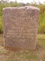
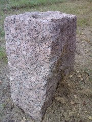
Marker #: 7
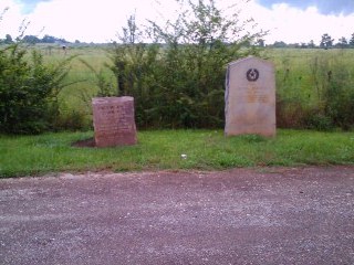
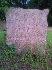
Coordinates: 31.522973, -94.115937 Location: Mission Dolores in San Augustine Relation to road: 25 ft from north curb, facing road, S 180° Distance from post: 300 ft east, on route Dimensions: 29" x 24" x 16" Setting: Grass Other Markers/Signage: Yes Visibility: High Accessibility: Fair When Zively made his survey of the Old San Antonio Road in 1915, the site of the old Mission Dolores was believed to be a spot called "Mission Hill", on the east bank of Ayish Bayou and on the north side of present-day State Highway 147, about a half mile south of Highway 21. Zively placed survey post #7 at Mission Hill. In 1936, a state historical marker was placed on Mission Hill, and Marker #7 was moved about 300 feet to be next to it. The identification of Mission Hill as the mission site always left archeologists unsatisfied, however. In the 1970's, a team of archeologists finally discovered that the mission site was actually about another 300 feet to the east, directly beneath Highway 147. Mission Hill, the true mission site, and Marker #7 are all along the Old San Antonio Road.1 The marker is on the grounds of the Mission Dolores / El Camino Real visitor center on Highway 147, about a half mile south of Highway 21. It is in front of the state historical marker for Mission Dolores. While the marker can be seen quite easily from the road, walking up to it to look or take a photograph is not easy. The highway has only two undivided lanes and has a curb, so pulling over next to the marker and stopping in front of it is either illegal, unsafe, or both. The intended way to see the marker is probably to park at the visitor's center and walk to it.2 Though this is not onerous, it definitely is a full stop, not a leave-the-engine-running quickie like most of the OSR markers are. Parking at the campground across the highway is another possibility. The marker itself is distinctive for being about four inches taller in front than in back. Additionally, the cylindrical grooves that are present on every OSR marker are especially prominent on this one - in fact, it was Marker #7 that caused this author to notice that these grooves exist on all them. While on most of the other markers, the grooves are light enough that they seem to have possibly been caused by abrasion (e.g. from cables), Marker #7 proves that they were drilled. Observed on August 10, 2013. |
|
|
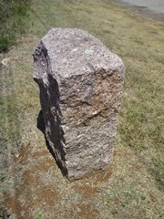
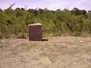
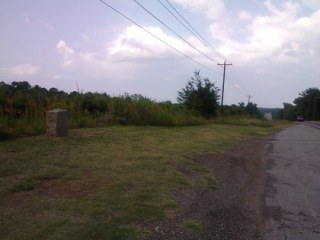
Marker #: 8
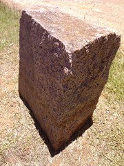
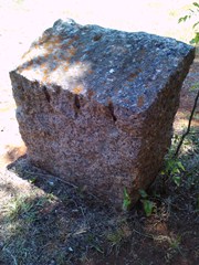
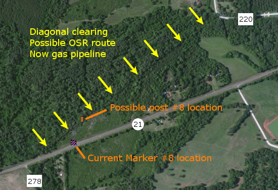
Coordinates: 31.52585, -94.19386 Location: On Highway 21 between San Augustine and Denning Relation to road: Distance from post: 0.1 mi south, on route Dimensions: 31" x 27" x 16" Setting: Grass Other Markers/Signage: No Visibility: Medium-High Accessibility: Very Good The marker site is 0.6 miles west of Venado Creek and just east of CR 278/Dwier Road. There is no road signage, but there is a traffic pulloff on the north side of the highway. The marker is in the center of a wide, mowed clearing at the top of a hill. It is easy to spot - a little easier when approaching from the west. A small chunk is missing from the top right rear corner of the marker. There are currently no other signs or historical markers, although there are a small concrete pedestal to the left and a steel post hole to the right, as if other markers once existed or were anticipated. According to Zively's sketch, on the west side of San Augustine, the King's Highway follows present-day County Road 220 west for a short distance. Where CR 220 makes a right turn north, the Kings Highway made a diagonal southwest to present-day Highway 21. From there, approximately at the intersection of County Road 278, Highway 21 is the true route of the Old San Antonio Road to Denning. Satellite images show a clearing in the forest corresponding very closely to the southwest diagonal on Zively's sketch. If this clearing is the King's Highway that Zively surveyed, then Marker #8 was originally placed along this diagonal line. It is now between the diagonal clearing and Highway 21, about a tenth of a mile south of its original location. This marker is off of Zively's route by no more than two hundred feet, if that, and so can be considered to still be on the route, for all practical purposes. The diagonal clearing seen in the satellite photo is now an easement for an underground gas pipeline. Observed on August 10, 2013. |
    |
|
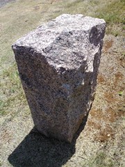
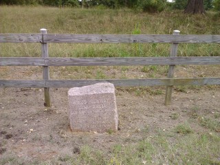
Marker #: 9
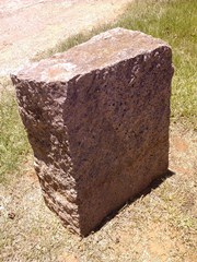
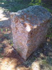
Coordinates: 31.505546, -94.270636 Location: On Highway 21 west of Denning Relation to road: 36 ft from south stripe, facing road, N 0° Distance from post: At post? Dimensions: 22" x 25" x 13" Setting: Dirt/grass Other Markers/Signage: No Visibility: Medium Accessibility: Good in dry weather This marker is 0.2 miles west of the west intersection of CR 256 and Highway 21, 1.1 miles west of Niciper Creek and 1.5 miles east of Farm-to-Market Road 1196. The Ratcliff Church of Christ is 0.4 miles to the west. The marker is on the south side of the road, across from a manufactured home at 8876 State Highway 21. It is in front of a wooden rail fence, set in dirt in a strip of mowed grass. There is some taller grass between the marker and the road. There is no pulloff, but the grass shoulder is good. To the east of the marker, the modern highway lies a little north of the old road, but to the west of the marker, it follows the old road exactly. Zively always placed his survey posts on the north side of the road, so depending on the precise point where his route coincides with the modern one, the marker might either be exactly at the spot of Zively's survey post, or the post may have originally been across the highway. This marker's whereabouts prior to 2011 are unknown. The Texas Society DAR did not find it during their 1995-2001 rededication project - the project web site misidentifies a featureless concrete block behind a fence 0.4 miles to the west as a DAR marker. A Google Street View photo from March 2008 shows that the marker was not at this site then. It can be seen casting a shadow in a November 2011 satellite photo. Even so, the El Camino Real de los Tejas National Historic Trail Association's interactive map in 2013 erroneously placed Marker #9 in San Augustine, close to Marker #7. Though it was placed at this site sometime between March 2008 and November 2011, it was not "discovered" here until our visit in August 2013. Observed on August 10, 2013. |
|
1Zively's sketch of San Augustine is problematic. The rest of his sketches of the Old San Antonio Road in east Texas can be laid on top of a modern map of Highway 21 of the same scale, and the commonalities and discrepancies can be easily identified. When it comes to San Augustine and post #7, however, this isn't possible. When comparing Zively's sketches of posts #6, #7, and #8 and the road between them, it appears as if the town of San Augustine is shifted about a quarter mile to the north. Therefore, on the above map, and on all other maps of the Old San Antonio Road on this web site, we use an 1849 plat map of San Augustine, which largely agrees with modern knowledge about El Camino Real, instead of Zively's sketch.
2There is a remnant of an old highway pulloff on the ground between the two markers. It is unusable now because of the curb on Highway 147.
- Zively, V.N. - "Field Notes and Detail Map of the Kings Highway", 1916
- Carson, David - field notes observed and recorded in 2013.
- Texas State Historical Association - The Handbook of Texas Online
- Texas Society of the DAR - Old San Antonio Road DAR Marker Information Site