
The Old San Antonio Road Posts and Markers in North Houston County
The Old San Antonio Road Posts and Markers in North Houston County
Also see The Old San Antonio Road in North Houston CountyZively placed ten oak survey posts in Houston County, four of which were in the northern part of the county shown on this map. Two of the matching granite markers are at their original locations on present-day Highway 21. The other two have been moved to Highway 21. Of those two, one was moved to a location along the Old San Antonio Road route, but the other is no longer on the route.
Map of the Old San Antonio Road in North Houston County
[-]Collapse Map [+]Expand Map
|
Marker #: 23
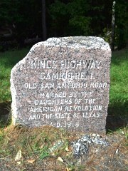
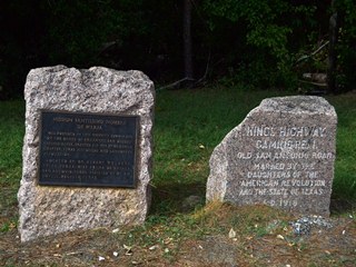
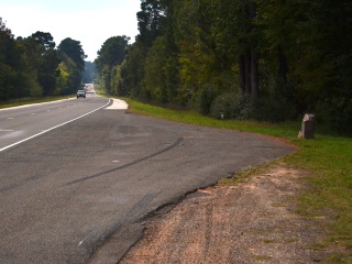
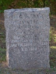
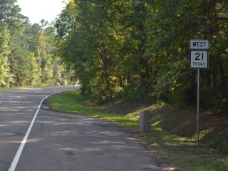
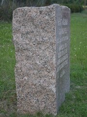
Coordinates: 31.576121, -95.168511 Location: SH 21 west of the Neches River Relation to Road: 18 ft from north stripe, facing road, SE 140° Distance from post: 0.7 mi southeast of post, off route Dimensions: 26" x 27" x 13" Setting: Dirt/grass Other Markers/Signage: Yes Visibility: High Accessibility: Excellent The Old San Antonio Road crossed the Neches River upstream from the present-day crossing of Highway 21. Its route is now on private property. The marker has been moved to Highway 21, about a quarter mile west of the bridge. It is on a highway pulloff that is easy to spot and well-marked with road signs. The marker is next to a state historical marker for Mission Santissimo Nombre de Maria, the second Spanish mission in east Texas. This mission stood for only a year plus a few months before being destroyed in a flood in January 1692. Its exact location is unknown. The plaque on the historical marker for the mission bears a date of 1934. This was about the same time that this section of Highway 21 was built, so the OSR marker may have been placed here at the same time. The granite marker is buried so deep that it appears wider than it is tall. There is a large chunk missing from the left top corner. Observed on October 26, 2013. |

|
|
Marker #: 24
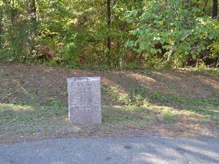
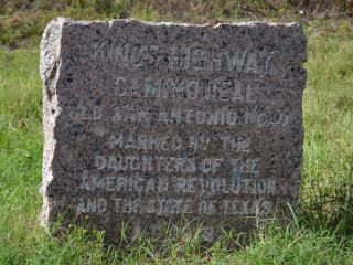
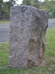
Coordinates: 31.526760, -95.247896 Location: SH 21 west of Weches Relation to Road: 15 ft from north stripe, facing road, E 80° Distance from post: 2.0 mi south of post, on route Dimensions: 33" x 25" x 13" Setting: Dirt/grass Other Markers/Signage: Yes Visibility: High Accessibility: Excellent The Old San Antonio Road followed the south bank of San Pedro Creek. Marker #24 was originally on the south bank of the creek, approximately at County Road 1585. It has been moved to the intersection of Highway 21 and Farm-to-Market Road 227, 1.4 miles west of the entrance to Mission Tejas State Park. The marker's present location indicates where Highway 21 resumes the route of the Old San Antonio Road. The marker is at a highway pulloff where a small clearing has been made in the forest. There is a historical marker sign pointing to the site, even though the OSR marker is the only object at the site.1 Observed on October 26, 2013. |
|
|
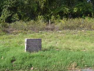
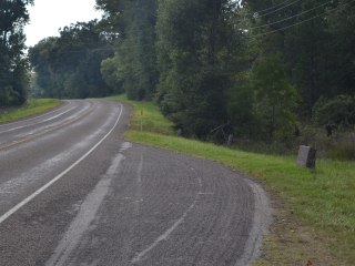
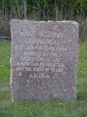
Marker #: 25
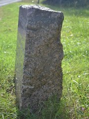
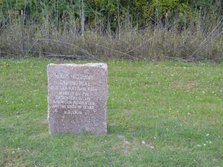
Coordinates: 31.493704, -95.273708 Location: SH 21 4.6 mi west of Weches Relation to Road: 18 ft from north stripe, facing road, SE 120° Distance from post: At post Dimensions: 26" x 28" x 11" Setting: Grass Other Markers/Signage: Yes Visibility: High Accessibility: Excellent This marker is in a grassy clearing at a pulloff on Highway 21, 1.5 miles west of the crossing for Bracken Creek and 1.5 miles east of the historical marker for the Pine Springs Campground. It is either at or very near its original location. There are historical marker signs on the road for the OSR marker. There are no other objects at the site. The marker is noticeably wider than it is tall. It is also unusually thin near the ground. It does not face the highway at a right angle; it is crooked. Curiously, the marker appeared to stand higher out of the ground when the Daughters of the American Revolution documented it for their 1995-2001 marker rededication project. We saw no evidence that it has moved or been reset since then, nor that the earth has built up around it significantly. It appears to have just sunk. Observed on October 26, 2013. |
 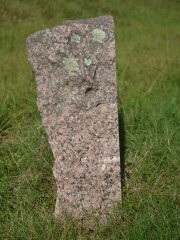
  Below: Marker #25 as it appeared in 1995. From the Texas Society DAR. 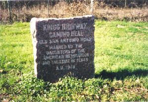
|
|
Marker #: 26
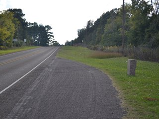
Coordinates: 31.432620, -95.321598 Location: SH 21 at Belott Relation to Road: 19 ft from north stripe, facing road, SE 130° Distance from post: At post Dimensions: 36" x 30" x 14" Setting: Grass Other Markers/Signage: Yes Visibility: High Accessibility: Excellent This marker is in the small rural community of Belott, 14 miles northeast of Crockett. It is just outside the boundaries of the Davy Crockett National Forest, at the intersection of Highway 21 and FM 1733. It is in a clearing of short grass at a highway pulloff that is marked with historical marker signs. The OSR marker is the only object at the site. It is at its original location. This marker is very typical in its appearance, and is in excellent condition. Observed on October 26, 2013. |
|
1Elsewhere in Texas, outside of Houston County, historical marker signs are not usually placed for OSR markers by themselves; they only have such signs when other historical markers are present with them.
- Zively, V.N. - "Field Notes and Detail Map of the Kings Highway", 1916
- Carson, David - field notes observed and recorded in 2013.
- Texas Society of the DAR - Old San Antonio Road DAR Marker Information Site