
The Old San Antonio Road in North Houston County
The Old San Antonio Road in North Houston County
- Map of the Old San Antonio Road in North Houston County
- Route Details
- Neches River and San Pedro Creek
- Highway 21
The Davy Crockett National Forest occupies 150 square miles of northeastern Houston County. This expansive forest of pine and hardwood trees was sold to the federal government in 1936 and was developed by the Civilian Conservation Corps. Today, it is used for lumbering, cattle grazing, hunting, and recreation. The Old San Antonio Road traverses approximately twelve miles of this forest. The first seven miles of the route no longer exist as public roads. It exists in some places as dirt trails, and is lost in other places.
Southwest of the town of Weches and Mission Tejas State Park, the Old San Antonio Road joins State Highway 21 and stays on it for the rest of the way through the forest and well on the way to city of Crockett.
Map of the Old San Antonio Road in North Houston County
[-]Collapse Map [+]Expand Map
Route Details
- Dirt trails and route lost from the Neches River for 6.8 miles to the intersection of SH 21 and FM 227N.
- SH 21 from FM 227N for 15.8 miles to FM 3187. This section conforms closely to the Old San Antonio Road.
Neches River and San Pedro Creek

The Old San Antonio Road as surveyed by V.N. Zively in 1915 crossed the Neches River at the river's northernmost point along the Houston-Cherokee county line. This was the territory of the Nabedache tribe, one of several Hasinai groups Spain attempted to convert to Christianity in the 17th and 18th centuries. A Spanish mission, named Mission Santissimo Nombre de Maria, existed here briefly in 1691 and 1692 before being destroyed in a flood.
Zively placed the survey post for OSR Marker #23 on the south bank of the river, noting that it was next to "Treasure Lake - Very Deep." No references to this lake have been found on any other maps or documents. After this crossing, the Old San Antonio Road went south for a short distance, then turned southwest, following the course of the river. The King's Highway had all but disappeared by Zively's time, however, having been replaced by a newer route that continued straight south from Marker #23. After about a mile, this "Road Now Used" forked, becoming the two roads that are now known as State Highway 21 and County Road 511.
Since Zively's day, his "Road Now Used" has itself disappeared, having become obsolete after Highway 21 was extended all the way to a new Neches River crossing about a mile downstream from the old one. A few feet of the "Road Now Used" can still be seen at the intersection of Highway 21 and County Road 511.
The map to the right, which is from 1906, shows how the roads through this area have changed in the last hundred years. Only 0.8 miles of the Old San Antonio Road on the south side of the Neches River existed in 1906. Today, all of this area is on private land, so there are no public roads. There are some private roads, dirt paths, and other trails that may happen to coincide with the historic roads for short distances, but the roads themselves have essentially disappeared. OSR Marker #23 has been moved to the new Neches River crossing at Highway 21.
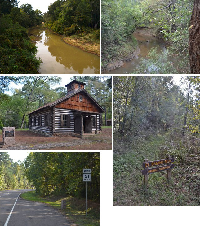
Middle (l to r): Mission San Francisco de los Tejas replica; El Camino Real footpath in Mission Tejas State Park.
Bottom left: Site of OSR Marker #24.
The Kings Highway followed the Neches River for about 3.7 miles. All of this section of the road is now on private property. Its route is not identifiable on satellite photos or topographical maps, and is probably mostly lost.
When the Old San Antonio Road reached San Pedro Creek, it turned to follow that stream's south bank for about 1.7 miles. The same 1906 map referred to earlier shows a road that corresponds roughly to present-day County Road 1585 crossing San Pedro Creek. While Zively did not show that road on his survey, he does show placing the post for OSR Marker #24 at or near its creek crossing. If CR 1585 is indeed the same road that existed in the early 1900s, then the granite marker was most likely once on the west side of CR 1585, just south of San Pedro Creek. The marker has since been moved to Highway 21.
Weches was founded in 1847. It was originally named Neches, and then Naches. The name was changed to Weches in 1887 because there was a town of Neches in Anderson County, and the U.S. Postal Service did not allow two post offices with the same name. The town's population peaked at 150 in 1936. In 2000, it had 26 residents and no businesses.
Mission Tejas State Park, which is southwest of CR 1585, was built by the U.S. Civilian Conservation Corps from 1934 to 1935. The park commemorates the Mission San Francisco de los Tejas, the first east Texas mission, established by Captain Alonso de León and Friar Damian Massanet in 1690. This mission was built among the westernmost clan of Nabedache natives, who were, in turn, the westernmost members of the Hasinai tribe. The mission became the first Spanish settlement along El Camino Real.
Mission Tejas was abandoned after three years, and its exact location is unknown. The park's location was chosen based on the discovery of some Spanish cannon parts nearby in 1928. The park includes what it calls a "replica" of the mission, also built by the CCC, but this should be considered as more of an artist's conception than a historical replica. Historians' best estimate is that the mission was about three miles west of the replica.
Mission Tejas State Park also features a historic cabin belonging to John Rice, which is discussed on our tour page for central Houston County.
A portion of El Camino Real is preserved in Mission Tejas State Park. This narrow trail through the brush parallels San Pedro Creek for about 400 feet, and is probably part of Zively's surveyed route of the Old San Antonio Road. It is accessed via a wide walking trail leading north from the park road. The Camino Real segment begins about a thousand feet north of the park road, and is indicated with signage.
Past the state park, the Old San Antonio Road leaves San Pedro Creek and breaks south. It goes almost due south in a nearly straight line for about 1.4 miles until it intersects with Highway 21 at Farm Road 227N. None of this route exists today. Highway 21 picks up the route of the Old San Antonio Road at FM 227N. This is also the current location of OSR Marker #24.
Highway 21
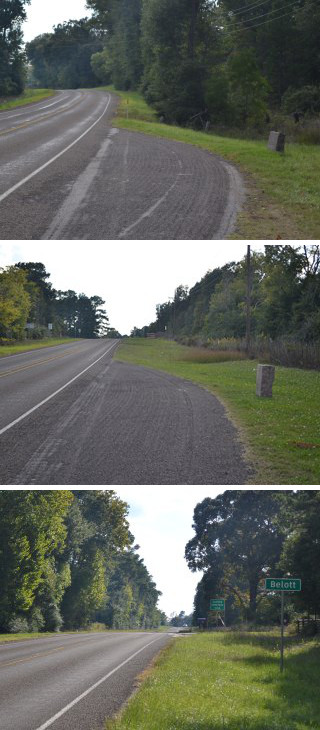
Middle: Site of OSR Marker #26.
Bottom: Belott highway signpost.
State Highway 21 follows the route of the Old San Antonio Road from FM 227N to FM 3187. The old road's many fine turns and zig-zags have been straightened out, but otherwise, this nearly 16-mile-long stretch of Highway 21 conforms closely to the Kings Highway.
The first 5.1 miles of this section follow the north bank of Pine Springs Creek. There are no towns or settlements here; the only features Zively noted on his survey are his own OSR Marker #25, which exists at its original location, and an "old stage stand" on Pine Springs. The state of Texas has placed a historical marker for the Pine Springs Campground very close to where Zively surveyed the stage stand. The text on this historical marker reads:
After a few more heavily-wooded, sparsely populated miles, Highway 21 emerges from the Davy Crockett National Forest. OSR Marker #26 and the community of Belott are just outside the forest's boundary. Belott was founded after the Civil War. Before World War II, it was a settlement with a church, a school and four stores. It is now only a dispersed rural community of farms, but the population has grown from 20 in 1965 to 101 in 2000.
Page last updated: February 24, 2014
- Zively, V.N. - "Field Notes and Detail Map of the Kings Highway", 1916
- Carson, David - field notes observed and recorded in 2013
- Texas State Historical Association - The Handbook of Texas Online