
The Old San Antonio Road Posts and Markers in West Brazos County
The Old San Antonio Road Posts and Markers in West Brazos County
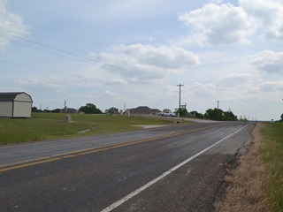
Also see The Old San Antonio Road in West Brazos CountyZively placed seven oak survey posts in Brazos County and on its boundary with Robertson County. Two of them were in the western section of Brazos County shown on this map. Both of them still exist, but they have both been moved from their original locations.
Map of the Old San Antonio Road in West Brazos County
[-]Collapse Map [+]Expand Map
|
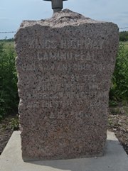
Marker #: 46
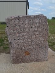
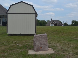
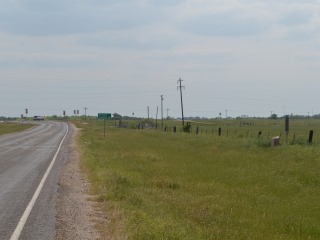
Coordinates: 30.702818, -96.488081 Location: Highway OSR, southwest of Highway 6 Relation to Road: 48 ft from south (east) stripe, facing road, W 270° Distance from post: 0.6 mi east (north) of post Dimensions: 34" x 28" x 20" Setting: Concrete Other Markers/Signage: No Visibility: Medium Accessibility: Excellent This marker is at the entrance to the El Camino Real Estates subdivision, on State Highway OSR about 3.5 miles southwest of State Highway 6. It is 0.2 miles east (north) of FM 1687/Sandy Point Road. It has been moved about 0.6 miles east (north) of its original location and has also been moved to the south (east) side of the road. An old, no-longer-used driveway that once ran through here now serves as a place to turn in and park to see the marker. The marker is built on a slope, and it is set level to the ground. As a result, the marker slopes to the left. There is a very noticeable 3½"x3½" rusty-looking square discoloration on the face, just below the engraving. A closer inspection of the marker's face also shows numerous long scratches on it. The storage shed seen behind the marker was built sometime between 2011 and 2014. When the Texas Society DAR did its OSR marker rededication project in 1995, the El Camino Real Estates subdivision did not exist. There was one house on the property that the subdivision now occupies, and the driveway to the house ran directly through the marker's current location. According to Marcy Heathman of the DAR, the DAR did not find the marker at first, but a few years later, the chapter president, Nancy Tiner, found it in the homeowner's garden. The homeowner told Tiner she found the marker in a ditch on the highway and had her employees move it to her house. After Tiner explained the marker's significance to the homeowner, arrangements were made for the Texas Department of Transporation to move it to the state highway, but the department kept it in storage for some time. The marker might have been placed at its current location in 2004 or 2005. A satellite photo dated 8 March 2004 shows that work on the subdivision had begun. At that time, the current subdivision entrance and some of the streets were open, but the older driveway was still very visible and might have recently been in regular use. A satellite photo from 21 October 2005 clearly shows that the driveway was no longer in regular use by then. This marker was definitely at its current location on 25 June 2006, when its coordinates were posted to Wikipedia. Observed on April 19, 2014. |
|
|
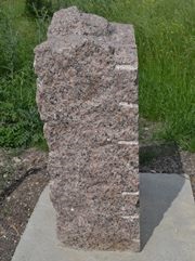
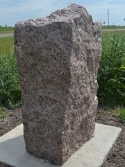
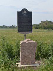
Marker #: 47
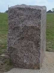
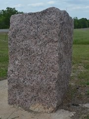
Coordinates: 30.645595, -96.505614 Location: Highway OSR at Highway 21 Relation to Road: 44 feet from north (west) stripe, facing road, SE 140° Distance from post: 1 mile from post, on route Dimensions: 35" x 28" x 14" Setting: Concrete Other Markers/Signage: Yes Visibility: Medium Accessibility: Medium in dry weather This marker is on Highway OSR 0.2 miles northeast of the intersection with Highway 21. It is on the north side of the highway, in front of a pasture fence. A state historical marker sign is planted right behind it. There is no pulloff, but the grass shoulder is suitable for parking. The marker is separated from the road by a patch of tall, sticky weeds and a low area that could fill with rainwater. There are no highway signs pointing to the area, even though there is a state historical marker at the site. The marker has a distinct hump at the top rear. It also is noticeably less wide in the back than in the front. As a result, the face and the rear of the marker have very different dimensions. The face measures 35" tall by 28" wide, while the rear measures 41" tall by 22" wide. The state historical marker behind the granite marker is about El Camino Real and the Old San Antonio Road. This is one of the few state historical markers about the road that refers to the DAR markers. This marker was originally on the west bank of the Little Brazos River, probably a little ways south of present-day Highway 21. It is about a mile northeast of that location today. It does mark Zively's route at its current location. This marker was not found by the Texas Society DAR during their 1995-2001 marker rededication project. Since there is no pulloff or other improvement to make the location visible from the sky, satellite photos are no help in determining how long it has been at this site. Presumably, it has been here since at least 1973, when the state historical marker was erected. Its current coordinates were posted to Wikipedia on 11 January 2008. Observed on April 19, 2014. |
|
- Carson, David - field notes observed and recorded in 2014
- Zively, V.N. - "Field Notes and Detail Map of the Kings Highway", 1916