
The Old San Antonio Road Posts and Markers in South Atascosa County
The Old San Antonio Road Posts and Markers in South Atascosa County
- Map of the Old San Antonio Road in South Atascosa County
- Marker #94
- Marker #95
- Marker #96
- Marker #97
- Marker #98
Zively placed nine Old San Antonio Road oak survey posts in Atascosa County. Five were placed in the southern part of the county shown on this map. Three of the markers can be seen on public roads. All three have been moved off of Zively's route, but are still within a mile of it. One marker, which has never been moved, is on a private ranch and cannot be visited by the public. The fifth marker has never been found.
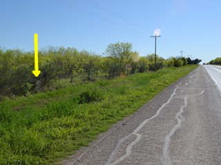
Map of the Old San Antonio Road in South Atascosa County
[-]Collapse Map [+]Expand Map
|
Marker #: 94
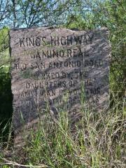
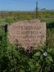
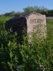
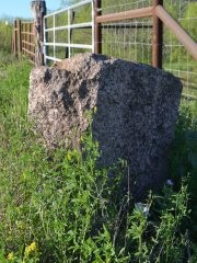
Coordinates: 28.916013, -98.596652 Location: SH 97 west of Jourdanton Relation to Road: 37 feet from south stripe, facing road, NW 320° Distance from post: 1.0 mi southwest of post, off route Dimensions: 36" x 25" x 15" Setting: Dirt, weeds, and brush Other Markers/Signage: No Visibility: Low Accessibility: Good This marker is on State Highway 97 west of Jourdanton. It is 0.5 miles west of Highway 97's intersection with Spur 162. It is on the south side of the road, on the right-of-way in front of a pasture full of mesquite trees. There is adequate room to park on the grass. The area is overgrown with weeds and brush, obscuring the marker's visibility. The marker is in good condition. A ground probe indicates that there is a layer of concrete a few inches beneath the topsoil. This marker was originally placed 1 mile northeast of here, on the part of the highway called Spur 162. When Zively surveyed the Old San Antonio Road in 1915, the state highways did not exist. Instead, the San Antonio, Uvalde, and Gulf Railroad was at this location. Zively placed the survey post for the marker where the Old San Antonio Road crossed the railroad north-to-south. Highway 97 and Spur 162 were subsequently built just north of the railroad, and then later, the railroad tracks were removed. Zively noted that Marker #94's survey post was 6.25 miles from the town of Charlotte, but the post was actually 8.6 miles from Charlotte. Observed on March 28, 2015. |
   |
|
Marker #: 95
Location: Not found This marker was placed south of present-day State Highway 97 somewhere between Jourdanton and Charlotte. Because of a discrepancy between page 89 of Zively's sketchbook, which surveys the OSR between Marker #94 and Marker #95, and page 90, which surveys the road between Marker #95 and Marker #96, the original location of Marker #95 cannot be determined with certainty. If page 89 is correct, the survey post for Marker #95 would have been placed approximately a half-mile south of Bluntzer Road, near a section of Atascosa County Road 319 that is presently closed to public traffic. If page 90 is correct, it would have been about a half-mile south of Highway 97, near a different section of CR 319. The map at the top of this page shows both possible locations, which are over a mile and a half apart. Based on our analysis of Zively's sketches laid over a map of the terrain, page 89 is more likely to be correct, which means that the Kings Highway would have run south of Bluntzer Road for most of the way between Jourdanton and Charlotte. It is also possible that both pages are wrong. OSR Marker #95 has never been found. Kenneth Burns, a lifelong resident of the Bluntzer Road area born in 1941, stated in 2015 that he roamed all over the area as a child and worked all over it as an adult and that his father remembered seeing wagon wheel ruts for the Old San Antonio Road near where it crossed La Parita Creek south of Bluntzer Road. Mr. Burns knew about OSR Markers #93, #94, and #96, and felt certain that if Marker #95 was in that area, he would have seen it or known about it also. Observed on March 28, 2015. |
|
|
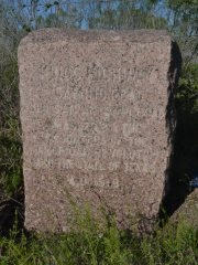
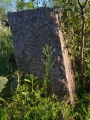
Marker #: 96
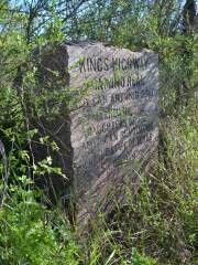
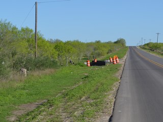
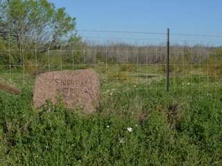
Coordinates: 28.835907, -98.689757 Location: FM 140 south of Charlotte Relation to Road: 24 feet from east edge, facing road, SW 230° Distance from post: 0.8 mi east of post, off route Dimensions: 35" x 25" x 14" Setting: Concrete, grass, and weeds Other Markers/Signage: No Visibility: Below average Accessibility: Fair This marker is on Farm-to-Market Road 140 2.0 miles south of the intersection with SH 97 in Charlotte. It is 1.0 mile south of Bluntzer Road and 0.4 miles south of County Road 334. It is on the east side of the road in front of the fence for a pasture. There is no shoulder on the road for stopping, and the grass shoulder is steep. It is probably ordinarily hard to spot because of the growth along the fence line, but at the time of our visit, the right-of-way had just been mowed, making it more visible. Zively drew the road that is now FM 140 on his sketch, labeling it "Charlotte & Christine Wagon Road." The Old San Antonio Road crossed this road about 0.2 miles north of present‑day CR 334. Zively placed the oak survey post for Marker #96 4,591 feet, or 0.9 miles, southwest of that crossing. It was subsequently moved to present-day FM 140, but it was placed about 0.6 miles south of the crossing. It is, therefore, no longer on his route. It was at its present location when the Texas Society DAR visited it between 1995 and 2001. Uneven weathering on the marker shows that it used to rest deeper in the earth than it does now. It is now raised up and set in concrete. The face and other surfaces of the marker are clean. Observed on March 28, 2015. |
 |
|
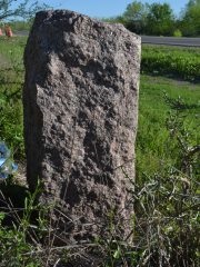
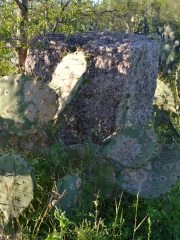
Marker #: 97
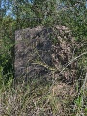
Coordinates: 28.782667, -98.740333 Location: CR 347 southwest of Charlotte Relation to Road: 26 feet from east edge, at angle to road, NW 300° Distance from post: 1.0 mi northeast of post, off route Dimensions: 27"x26"x12" Setting: Dirt and weeds Other Markers/Signage: No Visibility: Medium Accessibility: Fair This marker is on CR 347, 2.0 miles south of SH 97 and 1.0 mile south of CR 346. It is on the east side of the road in front of a wire fence, south of the gate. It is turned northward with respect to the road, so that it faces the road at nearly a 45-degree angle. Visibility can range from medium to low, depending on the height of the weeds. Accessibility is hindered not only by the lack of a good place to pull off, but also by the very poor quality of this county road. There is nothing exceptional about the marker from a physical standpoint. A ground probe indicates that there is a hard layer, possibly concrete, beneath the topsoil. This marker was originally placed about three quarters of a mile southwest of this location. Zively's route went in approximately the same direction in this area as SH 97 does now, only about a mile to the east. If the marker had been moved another half-mile northward on CR 347, it would have been on Zively's route. Observed on March 28, 2015. |
   |
|
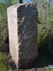
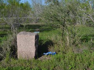
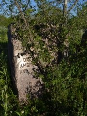
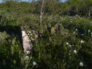
Marker #: 98
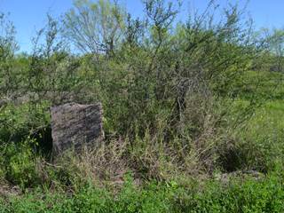
Coordinates: 28.708980, -98.786671 Location: Near Highway 97 and San Miguel Creek Relation to Road: none, oriented W 280° Distance from post: At post Dimensions: 37" x 26" x 18" Setting: Scrub brush Other Markers/Signage: No Visibility: N/A Accessibility: None - on private property This marker is in a pasture of prickly pears and mesquite trees east of SH 97 and north of San Miguel Creek. It is not accessible to the public and cannot be seen from the highway. According to Zively's survey notes, the oak survey post for this marker was placed about 800 feet east and 600 feet north of the SAU&G Railroad's crossing of San Miguel Creek. That point is now overlayed by Highway 97; the marker is some 500 to 600 feet southwest of it. Zively's sketch does not match his notes, however. Going by his sketch, the marker today appears to be at the same spot as his original survey post location. The property owner's son, who allowed us to document the marker in 2015, said that to his knowledge, it has never been moved. Going by this statement and by Zively's sketch, we are inclined to conclude that the marker is at the post location, and that Zively's notes are inaccurate. Furthermore, if it had been moved for Highway 97's construction, it would have been placed on the roadside or in some other conspicuous place - not just set out in a field hundreds of feet away, and left there. If this marker has never been moved, however, there is a problem - its orientation. According to his sketches, Zively placed all 123 survey posts for the Old San Antonio Road on the right-hand side of the road as one is traveling from the Sabine River to the Rio Grande - that is, the north or west side. The granite markers would have been installed facing the road - that is, south or east. Therefore, if this marker has never been moved, it should be facing east, not west. This assumes, however, that the granite contractor installed them correctly in the first place. In east and central Texas, OSR markers facing north or west are an anomaly; such an orientation is a sure sign that the marker has been moved. In south Texas, however, it is rare to find one mounted in the "correct" position and orientation. Does this mean that the granite contractor installed most of the south Texas markers incorrectly, or does it mean that they have been moved - including Marker #98? Unfortunately, the first attempt at a detailed audit of the markers was not made until 1995 - 77 years after they had been placed, and decades after most of them had already been moved, so that question may not have an answer. Observed on March 28, 2015. |
|
- Carson, David - field notes observed and recorded in 2015
- Zively, V.N. - "Field Notes and Detail Map of the Kings Highway", 1916
- Texas Society Daughters of the American Revolution - Old San Antonio Road DAR Marker Information Site