
The Old San Antonio Road in South Atascosa County
The Old San Antonio Road in South Atascosa County
Also see The Old San Antonio Road Posts and Markers in South Atascosa CountyThe Old San Antonio Road in southern Atascosa County starts on the west side of Jourdanton. It crosses into Frio County near San Miguel Creek. There are no modern roads or towns directly on the historic route today, but Highway 97 stays within about a mile of it for most of the way.
Southern Atascosa County is on the Eagle Ford shale formation, which has been one of the most active oil and gas drilling areas in the United States since around 2010.
Map of the Old San Antonio Road in South Atascosa County
[-]Collapse Map [+]Expand Map
Route Details
- Route lost from Spur 162 about 0.6 miles east of its intersection with State Highway 97 for 4.2 miles to County Road 319 about 0.4 miles south of Bluntzer Road.
- (There is a gap in Zively's survey, with a discrepancy of about 1.5 miles, between Jourdanton and Charlotte.)
- Route lost from CR 319 about 0.4 miles south of SH 97 for 16.9 miles to the Atascosa-Frio County line 0.8 mi south of San Miguel Creek.
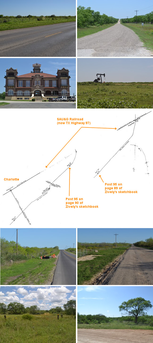
Second row (L to r): Atascosa County Courthouse in Jourdanton; oil rig in the Bluntzer Road area.
Third row: This comparison of Zively's sketchbook pages 89 and 90 shows a discrepancy on the route between Jourdanton and Charlotte and the placement of survey post #95.
Fourth row (l to r): Site of OSR Marker #96; site of OSR Marker #97.
Bottom row (l to r): OSR Marker #98 is a few hundred feet beyond this location; current appearance of the old townsite of Hindes.
State Highway 97
Zively's route in southern Atascosa County generally runs southwest from Jourdanton, crossing into Frio County near the "four corners" intersection of Atascosa, Frio, La Salle, and McMullen Counties. State Highway 97 has a similar route, but they are definitely not the same.
"The Sausage"
In 1912, the San Antonio, Uvalde, and Gulf Railroad extended a line from Fowlerton in La Salle County to Pleasanton in Atascosa County. This railroad was nicknamed "The Sausage" as a play on its abbreviation, "SAU&G." When Zively surveyed the Old San Antonio Road in 1915, he showed it crossing the SAU&G twice and generally staying in its vicinity otherwise. His references to the railroad, and distances given to it at certain points, help to ascertain the route of the OSR.
State Highway 97 was built in the 1920s largely along the SAU&G's right-of-way. The railroad tracks were removed in 1959. Today, Highway 97 serves as the modern reference point for Zively's sketches.
Zively placed the oak survey post for OSR Marker #94 on the south side of the SAU&G track about 1.6 miles west of Jourdanton. A spur off of Highway 97, Texas Spur 162, was built along this section of the railroad after the track was removed. This is the only original OSR marker location in southern Atascosa County that is on public property today. The marker has been relocated a mile west on Highway 97.
Jourdanton
Jourdanton was founded in 1909. Town co-founder Jourdan Campbell gave the community its name. County residents voted the following year to make Jourdanton the county seat. Like many railroad towns, Jourdanton's prosperity declined along with the railroads in the 1920s, but the discovery of oil in 1942 gave it a new chance at growth, and it has seen slow but steady increases in population every decade since.
Alonso de León
Governor Alonso de León led two pioneering expeditions into Texas in 1689 and 1690. According to historian William C. Foster in Spanish Expeditions Into Texas: 1689-1768, De León approached present-day Jourdanton from the west. His route, as depicted on Foster's map, could conceivably have followed the same east-west path currently used by Atascosa County Road 300 and State Highway 97. De León first traveled through this area on April 8, 1689.
Bluntzer Road - The Marker #95 Discrepancy
From OSR Marker #90 at the Atascosa-Bexar County line to the survey post for Marker #94 west of Jourdanton, it is possible to trace Zively's route with a reasonable degree of precision and confidence. By the same token, it is possible to trace Zively's route working backward from Marker #98 at San Miguel Creek to Marker #96's original location south of Charlotte. On the other hand, determining Zively's route between posts #94 and #96 and finding the original location of survey post #95 is very difficult. According to page 89 of Zively's sketchbook, the OSR crossed present-day Bluntzer Road close to Jourdanton, and survey post #95 was placed south of Bluntzer Road. According to sketchbook page 90, however, post #95 was placed south of the SAU&G railroad, and the OSR did not cross Bluntzer Road until near Charlotte. The two pages have a 1.5-mile discrepancy between them. The problem is illustrated on the map at the top of this page, where the two brown lines indicating Zively's surveyed route do not connect, and survey post #95 is indicated at two different locations.
Our analysis of Zively's sketches and notes lead us to prefer the route depicted on page 89, where the OSR crosses Bluntzer Road near Jourdanton and stays on the south side of Bluntzer Road all the way to Charlotte. This route fits well with the characteristics of the terrain, such as the near-universal tendency for roads to cross a creek downstream of a point where another creek flows into it, rather than having to cross two creeks that are close to each other. The northern route shown on page 90, on the other hand, makes much less sense when analyzed in this fashion.
Our conclusion that page 89's depiction is more accurate was corroborated when we interviewed Kenneth Burns, a lifelong resident of the Bluntzer Road area, in April 2015. Mr. Burns stated that El Camino Real crossed La Parita Creek south of Bluntzer Road, near where County Road 319 crosses it now. He said that his father remembered seeing the ruts from the wagon wheels.
Bluntzer Road passes through an oil-rich area, where drilling and pumping rigs are a common sight. Because oil operations can produce poisonous hydrogen sulfide gas, some of the county roads where operations are ongoing are closed to public traffic.
Charlotte
The town of Charlotte was founded in 1910 by a group of Atascosa County landowners. It was named by Dr. Charles Simmons after one of his daughters. Simmons' other two daughters, Imogne and Christine, also had towns in Atascosa County named after them. The SAU&G railroad built through here in 1912. As with Jourdanton, the discovery of oil nearby in 1946 allowed the town to survive and prosper after the railroad discontinued operations.
The Old San Antonio Road passed about a mile and a half south of Charlotte. It curved southwest to south-southwest, much as the railroad did in Zively's time and SH 97 does today. Zively's route is criss-crossed by numerous county and private roads. OSR Markers #96 and #97 have been moved from private property onto these roads.
Hindes
Zively showed the OSR crossing San Miguel Creek at the same location as the SAU&G railroad. When he came through here in 1915, the town of Hindes was on the railroad, a half-mile north of the creek. Hindes was founded by George F. Hindes, who settled there in 1856 and donated the land for the railroad right-of-way in 1912. At its peak in 1927, Hindes had a population of 100, a post office, a bank, a general store, a gin, a school, and two churches. It gradually declined after the railroad closed. It was a dispersed community of 14 people and no businesses by 1974. Even though the town's plat is still shown on some electronic maps, the townsite is now heavily-wooded ranchland; no trace of a town exists. The property in this area is still owned and farmed by George Hindes' descendants.
OSR Marker #98 is on private property north of San Miguel Creek and east of the former townsite of Hindes. It cannot be seen from any road.
Page last updated: June 15, 2015
- Zively, V.N. - "Field Notes and Detail Map of the Kings Highway", 1916
- Carson, David - field notes observed and recorded in 2015
- Texas State Historical Association - The Handbook of Texas Online