The Narváez Expedition came to Texas in five boats that were launched from northern Florida in 1528. The boats made their way westward along the Gulf coast, with the Spanish settlement of Pánuco, Mexico - near present-day Tampico - as their goal. All five of the boats made it as far as Texas, landing on the coast at various places and times. The 200 men who arrived on these boats were the first Europeans in Texas.
Alvar Nuñez Cabeza de Vaca's record of the expedition, La Relación, tells us where and on what dates two of the boats landed, but it provides less information about the other three boats. However, by using the information given about the five boats' progress from Florida to Texas and the details provided about the two well-documented boats, it is possible to project the course and speed of all five of the boats. From that, we can extrapolate the dates that the other three boats landed as well as gain more insight into what the men on all of the boats were experiencing during their ordeal on the Gulf of Mexico.
"On the twenty-second day of September, they had finished eating the horses, with only one left. On that day, we embarked in this order: forty-nine men went in the governor's boat; the same amount went in a boat given to the accountant and the commissary; the third was given to Captain Alonso del Castillo and Andrés Dorantes with forty-eight men; another to two captains named Téllez and Peñalosa, with forty-seven men; the other went to the inspector and I, with forty-nine men."
The journey from Flordia to Texas began at a place Cabeza de Vaca called the Bay of Horses. Historians have reached widespread agreement that the Bay of Horses was at Apalachee Bay, probably near the mouth of the St. Marks River. Cabeza de Vaca's boat, along with Captain Alonso del Castillo's, landed in Texas at a place he called the Isla de Malhado, or "Island of Misfortune." There is no doubt that this was in the Galveston Bay area. Formerly believed to be Galveston Island, a growing consensus of researchers and historians now believes that the Island of Misfortune was actually west of Galveston, on Follet's Island in Brazoria County. (Our analysis of Follet's Island for the Island of Misfortune can be found here.) Cabeza de Vaca's narrative gives the calendar date that the five boats left the Bay of Horses as September 22, 1528.1 Castillo's boat landed on the Island of Misfortune on November 5.2 Cabeza de Vaca's landed after dawn the next day, November 6.3
After launching from the Bay of Horses, the five boats navigated together, hugging the coastline and stopping as needed for food, water, and rest, until they had a serious problem: late one afternoon, they were driven away from the coast by currents and winds when attempting to cross the mouth of a river. After this happened, the boats lost contact not only with the coast, but also each other. At least four of the boats did not touch land again for a week or more, the one probable exception being the boat commanded by Governor Narváez. Cabeza de Vaca describes the passing of seven days and another night between the time that the boats were driven out to sea and when his boat landed on the Island of Misfortune. This means the unforunate incident at the river occurred on October 29. Note, however, that if the river crossing is calculated based on Cabeza de Vaca's timeline from the Bay of Horses forward, rather than from the Island of Misfortune backward, the date comes to November 2 - a discrepancy of four days. This is because Cabeza de Vaca describes a journey that lasts 50 days - 42 days up to and including the day the boats were swept out to sea, and 8 days after it - occuring between dates that are 46 days apart.4 We choose to stick with October 29 on the principle that the larger number, 42, is more likely to be in error than the smaller number, 8, and also because the 42 days between the Bay of Horses and the river include a span of thirty days during which Cabeza de Vaca recorded nothing happening. These thirty days may well have been a round number or estimate. While it is always possible that the start and/or end dates that Cabeza de Vaca gives are wrong, it seems that reducing this 30-day span to 26 days is the way to reconcile the discrepancy that does the least damage to the text.
" A half-league from where we were driven out, we sounded and found even with thirty fathoms, we could not take the depth; we could not determine whether the current was the reason we could not take it."
Identifying the large river where the five boats were carried away from the shore would help to reconstruct the timeline of the voyage. Looking at a map of the Gulf Coast of the United States, our eyes turn immediately to the Mississippi River, the largest river not only on the Gulf, but in the entire United States. The discharge from the Mississippi River is estimated at 593,000 cubic feet per second, which dwarfs the other rivers between St. Mark's Bay and Follet's Island. It is also important to note that the other rivers on the Gulf, including the Atchafalaya (225,000 cfs) and the Mobile (67,000 cfs) empty into bays before reaching the Gulf, whereas the Mississippi pours straight out. It is the only place on the coasts of Florida, Alabama, Mississippi, or Louisiana where boats could be caught in a current at the mouth of a river and swept out into open seas. Further confirmation is found in the text, where Cabeza de Vaca writes that the men attempted to take a sounding a half-league (1¾ miles) from shore with a 30-fathom line and could not touch bottom.5 The Spanish fathom (braza) was similar to the English fathom in that it represented the distance between the fingertips of a man's outstretched arms. The Spanish fathom may have been shorter than the English fathom - perhaps 5½ feet instead of 6 - but even so, the depth was greater than 165 feet. Cabeza de Vaca also wrote that the men could not be sure whether the current was the reason the line could not touch bottom. There is only one place in the Gulf of Mexico that is that deep so close to shore: the mouth of the Mississippi River.
Following the coastline, it is about 430 miles from St. Marks Bay to the Mississippi River. Taking more of a straight shot - for the boats were unable to follow the coastline after being swept out to sea - it is about 370 miles from the Mississippi River to San Luis Pass, where Castillo's boat landed. If the boats covered the first distance in 38 days and Castillo's boat covered the second distance in 7 days, that means the five boats went at an average speed of 11.3 miles per day before they reached the Mississippi, but Castillo's boat averaged 52.9 miles per day from there to Follet's Island. Is that possible? Is it reasonable? Or does it mean that our whole timeline is off? Let us turn again to the text. Cabeza de Vaca writes that the five boats spent seven days just getting out of the Bay of Horses, then another twenty-three days winding their way along the coast. It seems that the men were following the meanders of every small cove and inlet: Cabeza de Vaca writes, "Sometimes we entered coves and bays that reached very far inland."6 The boats were heavily loaded, with each one carrying fifty men, their belongings, food, and water. One day's water alone for fifty men would have weighed 400 pounds. The boats went with only six inches of hull above the water and moved very slowly. After a while, their water bags rotted, and the men modified the boats so that they rose up higher, so they were probably capable of moving faster, but now the need to find water demanded that they maintain a slow pace, because the men had to keep an eye out for fresh water sources. When they stopped at one island, only to find there was no water, they stayed there for six days because the sea was too rough to go back out. After five men died from drinking seawater, they decided that rough sea or not, they must continue their journey. So, yes, it does appear that the journey from the Bay of Horses to the Mississippi River proceeded at an excrutiatingly slow pace. All that changed when the boats were out on the high seas. There was no more meandering and no more stopping: the men were racing to reach the shore before they died of thirst and starvation. The boats were even lighter by this time because of the fewer men aboard. By the time the boats landed, their occupancy had gone down from about 250 total, or 50 apiece, to about 200 total, or 40 apiece. The texts only account for the loss of 10 men between the Bay of Horses and the Mississippi River, so whether the other 40 or so died before the boats reached the river or after is unknown. Regardless, by the time they reached land, each boat was nearly 2,000 pounds lighter simply from having fewer people aboard. They must have been considerably faster by then. Speeds of 50 miles per day or more are not at all unreasonable or unlikely, even in crude sailboats, for people who were traveling around the clock and trying to save their lives. Route interpreters who claim that the river that drove the boats out could not have been the Mississippi or that the boats could not have made it from the Mississippi River to Texas in a week have simply not thought the problem through.
Having set forth in the previous section the theory that the five boats were at the Mississippi River on October 29, 1528 and that one of the boats made it to San Luis Pass in seven days by traveling an average of 53 miles per day, we are ready to build a more complete timeline of the five boats' journey from the Mississippi River to Texas.
"We joined him there and took sweet water from the sea, because the river entered into the sea like a flood."
October 29: Trouble on the Sea
Cabeza de Vaca writes that at "the hour of vespers," or around sundown, he, in the lead boat, discovered a point of land on the near side of "a very large river and an islet." He anchored there to wait for the other boats, but Governor Narváez instead landed at "a bay very close by, in which there were many islets." At that place, they "took sweet water from the sea, because the river entered into the sea like a flood."7 The men went onto the island to cook some of their raw corn, but they could not find any wood for a fire. They then decided to cross the river, but in the process of that attempt, they were pushed out to sea by both the strong river current and a north wind. About two miles from land, they lowered a 30-fathom sounding line, but could not touch bottom. As stated in the previous section, this description has all the hallmarks of the Mississippi River, and could not have been anywhere else.
Looking at a modern map or satellite photo of the Mississippi River, one sees a very long, main channel snaking its way out into the ocean, then splitting off into three or four smaller ones. This last formation of small channels is called the Balize Delta or Bird's Foot Delta, and it is quite recent, having formed over the past 250 to 1,000 years. In Cabeza de Vaca's time, the mouth of the Mississippi River was north of its current location.
"We navigated nevertheless for two days, struggling to reach land. At the end of them, a little before the sun was gone, we saw many smoke columns on the coast. Working to approach there, we found ourselves in three fathoms of water."
October 31: Near the Coast
"We navigated nevertheless for two days, struggling to reach land," Cabeza de Vaca writes.8 As the sun was disappearing, the men saw "many smoke columns" on the coast, indicating native campfires. They took the boats in closer and measured a depth of three fathoms. The leaders decided it was too risky to land because it was nighttime and very dark and because there were so many campfires. "We decided to wait until morning," the text states.
The boats were probably off the coast of Bayou Lafourche in Lafourche Parish. The Lafourche Delta is the first land formation west of the Mississippi River, and is about 60 miles from the river's mouth. The boats were close enough to the shore to have been able to land, had they considered it safe to do so. This means that while sailing generally westward, they had also made some progress sailing north. If the north wind from two days earlier was still blowing, this may explain why they only averaged 30 miles per day, when later, while traveling straight west, they were able to travel almost twice that fast.
November 1: The Boats Become Separated
The men thought they would try landing on the nearby coast on the morning of November 1, but then they had another problem. Cabeza de Vaca writes, "When dawn came, each boat had found itself lost from the others. I found myself in thirty fathoms." Cabeza de Vaca's boat was back out in deep water, at least several miles south of the shoreline. His boat was separated from the other boats as well. His boat apparently was not the only one that got lost, for none of the five boats landed that morning as intended, and all of them ultimately landed in different places and at different times. The boats commanded by Alonso Enríquez and Alsonso del Castillo had no known contact with any of the other boats after October 31.
"I said to him that since I saw little chance of our being able to follow him and do as he had ordered, to tell me what it was that he was ordering me to do. He answered that this was no time for some to give orders to others, that each one should do what seemed best to him to save his life, and that is what he intended to do. Saying this, he sheared off with his boat."
What happened the night of October 31-November 1? We know the boats had only makeshift rock anchors9 and could have been moved by strong winds or currents, but if there was a storm or rough weather that night, Cabeza de Vaca does not mention it. Did everyone fall asleep? Even though it was dark, surely someone had to have known what happened. Unfortunately, the text provides no answers.
Cabeza de Vaca spent November 1 "continuing on my way," i.e. proceeding west. Near sundown, or "at the hour of vespers," he saw two of the other boats. He went over to one of them and found that it was Narváez's. Acting on the advice of his co-pilot, Pantoja, Narváez ordered his men to row to reach land, believing "if he did not reach land that day, that he would not reach it in six days." Cabeza de Vaca wanted Narváez to wait for the other boat, but he would not, because it "was very far out to sea." Cabeza de Vaca ordered his men to row, "but since the governor had with him the strongest and healthiest men of all, we could not keep up or follow him in any way." Narváez refused Cabeza de Vaca's request to throw him a tow line, told him he was own his own, and "sheared off with his boat."10
The next time Narváez's boat appears in the expedition chronicles is off the coast of Matagorda County some two weeks later. We are left to assume that he did reach land on the evening of November 1. Even if he did not, the above incident obviously occurred near the coast of Louisiana, about one day's travel west of the last location where they had intended to land. If the previous location was Bayou Lafourche, then the location where Narváez landed or tried to land was undoubtedly Terrebone Parish, on the west side of Terrebone Bay and about 50 miles west of Bayou Lafourche. Once the boats sailed past Terrebone Parish, they would have to cross the vast Atchafalaya Bay as well as keep making considerable progress heading northward before they would have another chance to reach land. This may explain Cabeza de Vaca's comment, supposedly originating from Pantoja, that their next chance to land would be in six days.
After Narváez left Cabeza de Vaca's boat behind, Cabeza de Vaca took his boat over to where the other one was. It was the one commanded by Captains Peñalosa and Téllez.

Order your copy of
The Account of Cabeza de Vaca: A Literal Translation with Analysis and Commentary, translated by David Carson of TexasCounties.net, available in E-book and paperback formats.
November 1 through 5: Crossing the Gulf
Cabeza de Vaca's boat joined with Peñalosa and Téllez's after sundown on November 1, then the two boats "navigated together for four days," but at "the end of these four days, a storm came to us, and we lost [sight of] the other boat."11 Assuming the writer means either that the boats were together for four periods of daylight or for four 24-hour days, and not just for parts of four calendar days, then they were together from the evening of November 1 until the evening of November 5.
There is no indication or suggestion that, after Narváez "sheared off in his boat" for the coast near Terrebone Parish, any of the other four boats saw the coast again for four days. Bayou Lafourche, where Enríquez and Castillo's boats were last seen; Terrebone Parish, where Cabeza de Vaca and Peñalosa's boats were; and Follet's Island, where Castillo and Cabeza de Vaca's boats landed, are all at approximately 29 degrees of latitude. This means that all four of these boats ultimately traveled straight west for about five days, covering about 300 miles, for an average speed of 60 miles per day. It is possible that the boats followed the concave shape of the Gulf shore between Terrebone Parish and Galveston Bay in an effort to land there, but we have no indication that they did. We know that Cabeza de Vaca's and Peñalosa's boats did not land on it, and we assume that Enríquez's and Castillo's did not either.
What we also do not know is whether the captains of the boats wanted to sail north and find land, but were prevented from doing so, or whether they simply made a decision to sail west as straight as possible, believing that would be the quickest way. Either explanation is plausible. The texts do indicate that north winds prevailed throughout the region from late October through at least mid-November: one is mentioned east of the Mississippi River on approximately October 25 (9:8), another on October 29 at the Mississippi (10:2), another at Follet's Island around November 10 (12:4), and another a few days later at Cavallo Pass (17:7). In fact, the texts do not mention any wind except north winds during this time. This would be consistent with the approach of winter (remember, these dates are according to the Julian calendar, and on our modern Gregorian calendar, all of them would be advanced by ten days), so it is possible that the boats struggled against north winds all the way from the Mississippi River to Galveston Bay. It is also possible, though, that the captains decided not to try to fight the winds and simply sailed west in as straight a line as they could.
"When night came, only the mate and I were left who were able to work the boat ... After midnight, I went to see whether the mate was dead."
In the afternoon or evening of November 5, Cabeza de Vaca's and Peñalosa's boats were separated by a storm. Considering that Cabeza de Vaca's boat landed on Follet's Island some twelve hours later, they were probably about 30 miles east of there when they were separated, or about at the longitude of the city of Galveston. Castillo's boat, which landed at San Luis Pass on November 5, had evidently traveled somewhat faster and at a slightly higher latitude. Castillo's boat may well have already been out in front of the others on November 1. It presumably had not been slowed down by a failed attempt to reach the coast at Terrebone Parish. We can only speculate about where Enríquez's boat was at this time, but seeing as how it ultimately ended up less than 20 miles from Cabeza de Vaca's, it was probably not all that far from his.
Cabeza de Vaca vividly describes the ordeal on the boats. The storm, and possibly other rains, may have given the men enough water to fend off dehydration, but all they had to eat from during this time was "half a handful of raw corn each day." After sundown on November 5, when his boat was alone again, "In accordance with the weather, and it being winter, and very cold, and suffering from hunger for so many days, with the injuries we sustained while at sea, the men began to become very dismayed the next day in such a way that when the sun went down, everyone who was in my boat had fallen down on top of each other, so close to death that few were conscious, and in that hour there were not five men standing."12
November 6: Two More Boats Land
The text plainly states that Cabeza de Vaca's boat landed on the Island of Misfortune aroun dawn on November 6, 152813 and that Castillo's boat landed on November 5.14 The time of Castillo's landing is unspecified, but unless his boat was traveling significantly faster than the rest, it was in the evening or at night. As our analysis shows in our article, "Identifying the Isla de Malhado," Castillo's boat landed at San Luis Pass, at the east end of Follet's Island, and Cabeza de Vaca's boat landed about seven miles west (or southwest) of there.
Cabeza de Vaca writes that around dawn, he heard the sound of breakers on the coast. Surprised, he took a sounding and determined that the depth was seven fathoms. With the intention of waiting until daybreak to land, he brought the boat in closer to the shore. A wave then heaved the boat up out of the water, and it came crashing back down, jolting all of the half-dead men back to life; Cabeza compared the waves tossing the boat to a horseshoe being tossed in a game.15
Comptroller Enríquez's boat, one of the ones about which we have less information, was found on the bank of a river that is believed to be the San Bernard in Brazoria County in the spring of 1529 by Andrés Dorantes's traveling party. The identification of this river is based on the Joint Report's note that it was the third of four coastal Texas rivers, located about three or four leagues past the second and largest river, which had to have been the Brazos. The boat was evidently in no condition to be used, for Enríquez and his men had already abandoned it, and Dorantes and his men walked past it without trying to use it. We have no information as to whether this boat wrecked at the San Bernard River straight out of the Gulf of Mexico, or whether it landed safely somewhere up the coast and Enríquez and his men continued to use it for a ways before losing it at the river. But, since the San Bernard River is only 25 miles from San Luis Pass and 18 miles from Cabeza de Vaca's probable landing site, the simplest theory about Enríquez's boat is that it traveled at about the same speed as the others, but took a slightly more southward course, and landed and wrecked at the San Bernard River on November 6. This theory also fits well with the timing of subequent events, such as the rendezvous with Narváez's boat a few days before the arrival of winter.
Order your copy of
Children of the Sun: Following in the Footsteps of Narváez and Cabeza de Vaca, by David Carson of TexasCounties.net, available in E-book and paperback formats.
November 9: The Massacre
... there were others further, called Camones, who live toward the coast, and who had killed all of the people who came in Peñalosa and Téllez's boat. They were so weak, that although they were being killed, they could not defend themselves, and so they finished them off. They showed us some of their clothing and weapons and told us that the boat was there, on its side.16
The above passage from La Relación is all that is known about Peñalosa and Téllez's boat after it was separated from Cabeza de Vaca's on November 5. The passage implies that the men were massacred near their boat, perhaps as they were landing, or perhaps when they were camping near it after having recently landed. The note that the boat was on its side implies that it wrecked there, although the story is being related years after the fact, so it could have been turned on its side by storms or tides.
Little is known about the Camones or Camoles except that they were further down the coast from any of the tribes that the other Narváez Expedition survivors encountered, such as the Quevenes and Guaycones. They must have been no further north than Corpus Christi Bay; our analysis in our article, "Interpreting the Territories of the Coastal Natives Described by Cabeza de Vaca," places them in the area of Baffin Bay in Kleberg and/or Kenedy County.
As with Enríquez's boat, there are several possibilities for what happened to this one, but the most straightforward theory is that it remained at sea after it was separated from Cabeza de Vaca's boat on November 5 until it finally landed and wrecked off the coast of south Texas. If that is what happened, then after the storm on November 5, the boat changed course from west to southwest. (The pilots of that boat may have previously relied on Cabeza de Vaca's boat for direction.) This, unfortunately, put them on an almost parallel path with the coast for another 200 miles. If they managed to maintain the same speed as before - 50 to 60 miles a day - they spent another four days at sea before finally coming to land. The men would have been so close to starvation by that time, it is no wonder they were too weak to defend themselves.
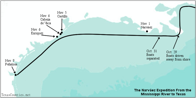
Figure 1. The Narváez Expedition from the Mississippi River to Texas.
Using the information provided in the Narváez Expedition chronicles - especially Cabeza de Vaca's La Relación - we can project the progress of the expedition's five boats on the Gulf of Mexico as outlined below and as illustrated in Figure 1, above:
- The five boats left St. Mark's Bay, Florida on September 22, 1528.
- The boats spent about five weeks navigating slowly westward along the coast of Florida, Alabama, Mississippi, and Louisiana, examining the bays and coves and making regular stops for food, water, and rest.
- On October 29, the boats were swept away from the coast while attempting to cross the mouth of the Mississippi River. (The Balize or "Bird's Foot" Delta was smaller or did not exist at that time.)
- Around nighttime on October 31, the boats approached the Louisiana coast near Bayou Lafourche, but the men decided to wait until morning before attempting to land. That night, however, the boats were driven back out from the coast as well as away from each other.
- Around sundown on November 1, Cabeza de Vaca's boat saw Narváez's boat and the Peñalosa-Téllez boat off the coast of Terrebone Parish. Narváez took his boat in that evening and made land. Cabeza de Vaca's and Peñalosa's boats did not.
- From the evening of November 1 to November 5, Cabeza de Vaca's and Peñalosa's boats navigated west together approximately at 29°N latitude. Castillo's and Enríquez's boats did likewise, although they were each separated from the others.
- On the evening of November 5, Castillo's boat landed on the east end of Follet's Island in Brazoria County at San Luis Pass. Cabeza de Vaca's and Peñalosa's boats became separated in a storm.
- Cabeza de Vaca's boat landed on Follet's Island around dawn on November 6. Enríquez's boat landed at the San Bernard River in Brazoaria County later that day.
- The Peñalosa-Téllez boat remained at sea for four more days, eventually coming to a stop on North Padre Island near Baffin Bay.
By David Carson
Page last updated: July 5, 2020
